
A wrap-up of posts published on Maven’s Notebook this week …
Note to readers: Sign up for weekly email service and you will receive notification of this post on Friday mornings. Readers on daily email service can add weekly email service by updating their subscription preferences. Click here to sign up!
This week’s featured articles …
FEATURE: Water rights key to San Joaquin Valley aquifer recharge
 Written by Robin Meadows
It sounds like such a simple fix for California’s groundwater woes. In phenomenally wet years like this one, when reservoirs are so full water is still being released to make room for snowmelt, just use some of that liquid wealth to inundate agricultural lands above severely overdrafted aquifers.
But nothing is simple in the world of California water. This approach, called managed aquifer recharge, has a host of complications including sorting out who has rights to floodwaters, how to allocate those rights equitably, and whether plans for securing those rights for recharge are realistic.
Click here to read this article.
SCIENCE SPOTLIGHT: Yolo Bypass floodplains and fish food
 The Yolo Bypass was originally designed as a flood control measure to protect the city of Sacramento. It is also widely viewed as an environmental and water management success story, as it has been demonstrated to achieve multiple benefits, including benefits to agriculture, flood control, and the environment that derive from reestablishing the connectivity of a major river to its floodplain.
Previous reports have highlighted studies that document some of the environmental benefits. In a study referred to as the Nigiri project because of its benefits for both rice and fish, researchers funded by the Delta Stewardship Council, Department of Water Resources, and others demonstrated that managed inundation of the Yolo and Sutter bypasses at times not necessarily needed for flood control resulted in the generation of large amounts of fish food, zooplankton and higher growth rates and larger sizes of juvenile Chinook salmon that were using the floodplain for foraging and shelter.
Click here to read this article.
In California water news this week …
Here comes El Nino: It’s early, likely to be big, sloppy and add even more heat to a warming world
 “An early bird El Nino has officially formed, likely to be strong, warp weather worldwide and give an already warming Earth an extra kick of natural heat, meteorologists announced. The National Oceanic and Atmospheric Administration Thursday issued an El Nino advisory, announcing the arrival of the climatic condition. It may not quite be like the others. It formed a month or two earlier than most El Ninos do, which “gives it room to grow,” and there’s a 56% chance it will be considered strong and a 25% chance it reaches supersized levels, said climate scientist Michelle L’Heureux, head of NOAA’s El Nino/La Nina forecast office. “If this El Nino tips into the largest class of events … it will be the shortest recurrence time in the historical record,” said Kim Cobb, a climate scientist at Brown University. … ” Read more from the Associated Press.
SEE ALSO:
- NOAA declares the arrival of El Nino: Expected to be moderate-to-strong by late fall/early winter, from NOAA
- El Nino is officially underway. Here’s what that means for the weather, from AccuWeather
Two California lakes are making comebacks with different results
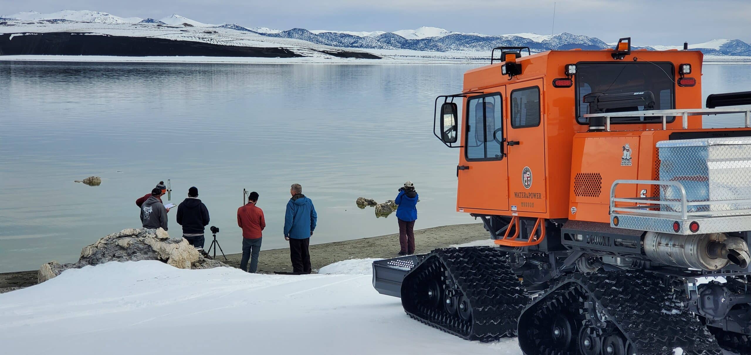 “Some of California’s biggest lakes are making dramatic comebacks as the state’s “big melt” of snowpack reshapes the landscape in historic — and perhaps unexpected — ways. Owens Lake, which dried up in the 1920s after its streams were diverted to quench the thirst of Los Angeles, has re-emerged. The new water on the dry lake bed threatens to damage infrastructure designed to keep down dust, a problem that emerged when the lake was drained decades ago. … Meanwhile, Mono Lake, beleaguered by three years of drought, is expected to rise by several feet, a welcome reprieve as the lake has struggled to reach target levels. The contrast between the two lakes, which are about 115 miles from one another, shows the complicated and differing impacts of the “big melt,” as meteorologists have nicknamed the process. … ” Read more from NBC News.
Lake Oroville spillway in active use as Lake Shasta nears capacity as well
 “The Feather River is getting a fair amount of extra water flow these days as Lake Oroville has been releasing water over the last week. Oroville is California’s second-largest reservoir, with a capacity of over 3.5 million acre-feet of water, and also just about at capacity is the state’s largest reservoir, Lake Shasta, which has a capacity of 4.5 million acre-feet and is at 98%. … ” Read more from SFist.
SEE ALSO:
- Two of California’s largest reservoirs are near 100% capacity. Here’s where others stand, from the SF Chronicle
- California Reservoir Rebound, image from NASA’s Earth Observatory
Rights to California’s most important resource are built on injustice. New legislation seeks to change that
“Who gets California’s water, and how much, is a high-stakes affair, and it’s based on a system of water rights born long ago, when the West was wild — and often unfair. The first-come, first-served pecking order established during European settlement gave the new and dominant landowners first dibs on pumping rivers and creeks. The beneficiaries, which include the likes of San Francisco and its pristine supplies in Yosemite, continue to enjoy tremendous advantage, consuming water with little constraint while others sometimes go without. Amid growing water shortages and focus on equity, the system has begun drawing increased scrutiny. Last week the state Legislature weighed in with the unusual step of advancing measures that would help regulators rein in the most privileged and profligate water users. … ” Read more from the San Francisco Chronicle (gift article).
‘Improvised, spotty and belated’: Will California reform its oversight of water rights?
“California’s complex system of water rights took shape starting in the mid-1800s, when settlers saw the state’s water as abundant and free for the taking — a time when a Gold Rush prospector could stake claim to river flows simply by nailing a notice to a tree. Today, California’s oldest and most senior water rights — called riparian and pre-1914 rights — have been passed along to thousands of agricultural landowners, irrigation districts and urban water suppliers that claim control of roughly one-third of the water that is diverted from the state’s rivers and streams. … Legal experts say the way the state manages this antiquated system is in dire need of reform. Among other problems, they say, current law prevents officials from verifying whether claims of senior water rights are valid, ordering those water users to reduce usage, or imposing fines that are large enough to penalize those who flout the rules. Three bills gaining momentum in the Legislature are seeking to change that, even as they draw heated opposition from water agencies and agricultural groups. … ” Read more from the LA Times. | Read via Yahoo News.
California ranchers intentionally violated an emergency water order. Now lawmakers want to triple the fines
“When ranchers violated an emergency order to stop pumping water from the drought-plagued Shasta River last year, state officials fined them $4,000, or roughly $50 each. Now California legislators are weighing a bill that would triple fines for such infractions — and could allow the penalty to climb higher than a million dollars. Authored by Assemblymember Rebecca Bauer-Kahan, a Democrat from San Ramon, the bill cleared the Assembly in a 43 to 20 vote last week and is now awaiting discussion in Senate committees. The proposed legislation aims to give California’s water enforcers more muscle to act swiftly and levy larger penalties for water agencies, irrigation districts and landowners who violate state orders and policies by pumping from rivers and streams. … ” Read more from Cal Matters.
Report on water tunnels called flawed
“The Delta Protection Commission has recently discovered that the draft environmental impact statement on the Delta Conveyance Project has failed to adequately describe the potential effects of the planned twin water tunnels. According to recent comments the Delta Protection Commission sent to the U.S. Army Corps of Engineers on March 15, the Commission has recommended that the Corps adopt a “No Action” alternative as opposed to approving permits necessary for the tunnels due to the project’s potential significant and unmitigated damage to cultural and historic resources in its path. The U.S. Army Corps of Engineers is a federal regulator that decides whether to authorize the project. … ” Read more from The Press.
Sites Reservoir water right application moves forward
 “The Sites Project Authority (Authority) received notification from the State Water Resources Control Board (SWRCB) that the Sites Reservoir water right application has been deemed complete. Accordingly, the Sites Reservoir Project is moving forward to the next step in the process toward issuing a new water right permit for the project. A water right permit will provide the Authority legal authorization to divert water within certain conditions, for a specific purpose, and for use within a specified area. The Authority will be the State designated steward of the water right for the Sites Reservoir Project. “We are excited to move into this next phase of the permitting process, which builds on the momentum we’ve had this past year,” said Jerry Brown, Executive Director of the Authority. “We welcome the public review of our work, and we are confident in our analysis that the Sites Reservoir Project can safely and reliably serve as a key component of new infrastructure to manage California’s water in light of our changing climate.” Read more from the Sites JPA.
How Sierra Nevada snowpack confounds Central Valley groundwater readings

“Billions of tons of snow piled atop the Sierra Nevada Mountains can cause parts of the Central Valley, just west of the range, to sink – muddling groundwater assessments that take sinking as a sign of depleted aquifers. A recent Stanford University study is now offering a way to account for this heavy mountain snowpack and more accurately gauge groundwater levels. Analyzing satellite-based measures of surface changes over time has emerged as a promising method for monitoring groundwater in places such as the agriculturally rich Central Valley, where farmers rely heavily on groundwater to irrigate crops in dry years. But the method requires a clear understanding of the true mechanisms behind any observed elevation changes. The new study, published April 28 in Geophysical Review Letters, shows how heaped-up snow and ice in the Sierra during California’s wet season depresses the valley floor, accounting for the majority of the detected elevation change in 60% of the valley. … ” Read more from Stanford News.
Ag land values benefit from recharge, runoff
 “Groundwater recharge efforts in Fresno Irrigation District (FID) could be one of the reasons the region tends to command higher farmland values than neighboring areas. The district’s rights to Sierra runoff certainly helps. The 2023 Trends Report, published by the California Chapter, American Society of Farm Managers and Rural Appraisers, reported earlier this year that FID permanent cropland values last year climbed to $48,000 per acre for good quality, young tree nut orchards. This compares to a ceiling of $25,000 for non-FID almond property in Fresno and Madera counties. … ” Read more from the Western Farm Press.
Domestic wells still going dry in San Joaquin Valley towns as historically low groundwater levels are slow to rebound
“The small town of Tooleville ran out of water and started receiving water hauled in by truck on June 5. It’s the first time the town has needed hauled water since October of 2022. Despite the historic snowpack and storms this year, groundwater levels in some areas are still low and wells are still going dry. Tooleville, in rural Tulare County, has been plagued by water problems for decades. Its two community wells struggled to produce enough water on and off for years as surrounding farms had to pump more groundwater in the recent multi year drought. Residents there are used to relying on hauled water that fills two storage tanks, which were installed by nonprofit Self-Help Enterprises. The big issue for Tooleville this time around is overuse in combination with slow groundwater recharge. … ” Read more from SJV Water.
DWR and partners experiment with soft release method to improve Delta smelt survival

“Delta smelt are a fish that have gone from vast abundance to the brink of extinction. After seeing some positive results with releasing hatchery-raised Delta smelt into the wild in 2022, the Department of Water Resources (DWR) and partners are now experimenting with hard and soft release methods to see if there is a chance for even greater success and improved species survival. DWR Senior Environmental Scientist Trishelle Tempel explains the difference between the two methods. “In a hard release we essentially load the fish up and put them directly in the river, but in a soft release we take those same fish and put them in an enclosure and that gives them time to get used to their surroundings, maybe slow down some of their stress levels, and hopefully prepare them for better success when they get out into the water,” Tempel said. … ” Read more from DWR News.
Improved passage lets threatened sturgeon, salmon and other species return to spawn in Sacramento River
 “Dozens of adult sturgeon and hundreds of other large fish including threatened Chinook salmon have moved safely from receding floodwaters within the Yolo Bypass back to the Sacramento River thanks to the coordinated operation of the Fremont Weir Adult Fish Passage among the California Department of Water Resources (DWR), the California Department of Fish and Wildlife (CDFW), NOAA Fisheries and Yolo County. Over one 48-hour period when the Fremont Weir Adult Fish Passage was opened on April 28 and 29, the facility’s fish-counting sonar counted 55 sturgeon passing through the facility to the Sacramento River to migrate upstream and spawn. Sturgeon are large fish that often measure 6 to 7 feet long and certain species can live over a century. They must reach the river to spawn, which they do only every few years. In another 24-hour window between May 3 and 4, seven more sturgeon passed through the facility. Hundreds of other large fish and Pacific lamprey were also counted moving back to the Sacramento River during the two operational windows in April and May. … ” Read more from CDFW.
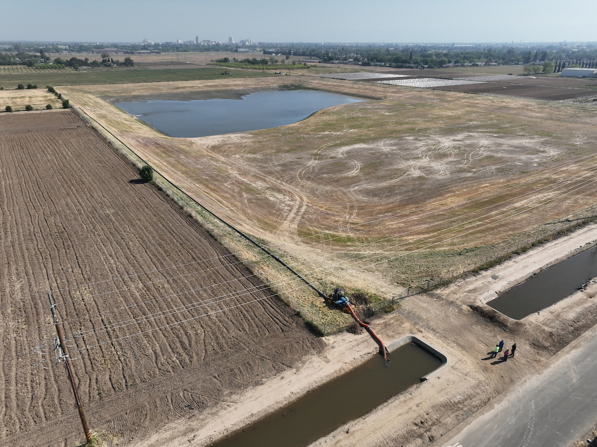
Over 1 million acre-feet of water authorized for groundwater recharge since December

Odin Abbott / DWR
“Seizing the opportunity from an extremely wet winter and spring to boost groundwater levels, the State Water Resources Control Board since late December 2022 has authorized the diversion of 1.2 million acre-feet of water – more than enough to fill the Folsom Reservoir – for underground storage, wildlife refuges and other purposes. “Planning for future dry conditions is critical to protecting our communities, health, and our environment,” said California Secretary for Environmental Protection Yana Garcia. “The state has taken unprecedented action to leverage the benefits of our recent wet weather by replenishing our groundwater resources through recharge, and we look forward to achieving even more progress in the future with partners across the state. This is just one example of how our state is creating a more resilient water supply for all Californians in the face of climate-driven weather extremes.” … ” Continue reading from the State Water Resources Control Board.
US-German satellites show California water gains after record winter
“After years of intense drought and diminishing groundwater, California just saw its greatest year-over-year water gains in two decades, according to data from the GRACE-FO (Gravity Recovery and Climate Experiment Follow-On) satellite mission, a partnership between NASA and the German Research Centre for Geosciences (GFZ). This past winter’s bonanza of atmospheric rivers alleviated some of the water deficit that the state incurred during periods of drought over the last 10 years, which included the three driest years on record in California. … ” Watch short animation below and read more from JPL.
California lawmakers eye new trims to judicial process to sidestep environmental red tape
“A debate in California’s Assembly about whether to fast-track bills looking to trim down the state’s notoriously laborious environmental review process caused some pushback on behalf of public transparency. State lawmakers convened the last in a series of informational committees serving as the first public hearings on Governor Gavin Newsom’s proposed policy and budget package for the coming year. Newsom released his proposals to improve the speed of infrastructure projects on May 19, saying that his eight-bill package will streamline project approval, maximize California’s federal infrastructure dollars and expedite projects to meet economic and climate goals. … ” Read more from the Courthouse News Service.
SEE ALSO:
- Groups Blast Governor’s Destructive CEQA Budget Trailers at Legislative Hearing, from Dan Bacher at the Daily Kos
- Newsom’s proposed CEQA budget trailers face criticism, from Restore the Delta
Researchers find why San Andreas fault hasn’t caused a big earthquake in L.A. — yet
“The southern San Andreas fault in California is in a seismic drought, going more than 300 years without a major earthquake. New research shows the lack of seismic activity may be due to the drying of the nearby Salton Sea and provides clues on future potential earthquake triggers, including projects aimed to refill the body of water. One of the largest faults in the world, the 800-mile-long San Andreas marks the meeting of the North American and Pacific plates in western California. The fault has three sections, but the southern section from the Salton Sea to Parkfield, Calif., has been historically the quietest — and that’s not a positive. The pent-up energy, when released, could be catastrophic to nearby populated cities. The new study, published Wednesday in Nature, investigated earthquake activity along the southern San Andreas fault over the last 1,000 years. Collecting field data from rocks near the fault, Hill and his colleagues found earthquakes occurred about every 180 years, give or take 40 years, and coincided with high water levels of the nearby ancient Lake Cahuilla. … ” Read more from the Washington Post (gift article).
In commentary this week …
Commentary: California needs smart water policy, guided by data
Justin Fredrickson, a water and environmental policy analyst for the California Farm Bureau, writes, “Advocates for California agriculture have had quite a bit to say about the state’s maddening failure to capture more water in wet years when it’s available. We have also expressed related concerns about fixing the burdensome water rights permitting process, which can begin to correct some of this problem. Despite legislative and administrative attempts to authorize temporary 180-day and five-year permits to allow harvesting floodwater to recharge depleted groundwater supplies, few permits have been secured. The timing of approvals is also often out of sync with the timing of available water. A March 10 executive order by Gov. Gavin Newsom during the atmospheric storms made it easier for agricultural landowners to divert excess water to recharge aquifers and reduce flooding dangers. It was a major step, yet the long-term process needs to be further streamlined for a durable solution. … ” Read more from Ag Alert.
The Tulare Basin represents the wrong approach to flood planning
Sacramento Bee opinion writer Tom Philp writes, “When it comes to flood protection in the San Joaquin Valley, it is a tale of two stories. In most of the San Joaquin River watershed, where the state and locals work together year in and year to better protect the region. And then there is where it is now flooding, the Tulare Basin, which has preferred to be left alone. There is an explanation, involving the state’s unofficial king of the Boswell lineage. The Legislature in 2008 declared that for San Joaquin Valley flood planning purposes, the Tulare Basin, which is spans parts of Tulare and Kings counties between Stratford, Corcoran and Kettleman City, is simply not in the San Joaquin Valley. … ” Read more from the Sacramento Bee.
California agriculture could use an ancient history lesson
Ángel S. Fernández-Bou, a Senior Climate Scientist at the Union of Concerned Scientists, writes, “When I was an agricultural engineering student, I took a class called History of Agriculture. I loved that class, in part, because I love agriculture, but also because I love ancient history. I used to study ancient history just for fun, and when I had the opportunity to write a paper for that class, I decided to write about the origins of agriculture and civilization in Mesopotamia and Egypt. Mesopotamia is one of the cradles of human civilization. Agriculture started there about 10,000 years ago, and about 5,500 years ago they invented the cuneiform writing system. The first documents ever written were about agricultural production! … ” Read more from the Union of Concerned Scientists.
Which is it California – a flood emergency or a drought emergency?
Katy Grimes, editor of the California Globe, writes, ““Meteorologists forecast that June will bring above-normal temperatures to California, which could worsen the state’s remaining drought,” the Sacramento Bee reports today. Ah. This is from the same meteorologists who could not or would not forecast the record rain and snowpack we had this past winter – statewide snowpack averages came in at 237% of average. “According to the National Oceanic and Atmospheric Administration, there’s a 33% to 50% chance weather in California will be hotter than usual for this time of the year.” Well, that would fit in with their climate change propaganda goals. .. It’s hot. It’s cold. It’s raining. It’s dry. Nowhere does The Sacramento Bee ever say that it’s normal. … ” Continue reading at the California Globe.
In regional water news this week …
New fishing regulations proposed for Klamath River following dam removal
“The Oregon Department of Fish and Wildlife is considering modifying current fishing regulations along the Klamath River in 2024. ODFW says this is due to the removal of JC Boyle dam in 2024. A public meeting is scheduled for June 8, 6 p.m. at the Klamath County Fairgrounds Linman Hall. ODFW will give a short presentation of the proposed changes and will allow a chance for the public to ask questions and offer comments. ODFW says the changes will help accommodate salmon, steelhead, and Pacific lamprey that will soon have access to the upper Klamath Basin for the first time in over 100 years. … ” Read more from KOBI 5.
Bringing the Sacramento Valley to life: Investing in multiple benefits through floodplain reactivation and nature-based solutions
“There are unique opportunities in the Sacramento Valley to reactivate floodplains, mimicking historical natural processes to improve habitat for fish, birds and other wildlife, enhance flood protection and groundwater recharge, and increase California’s resilience to climate change by better preparing the state for future droughts and floods. These nature-based solutions are a new way forward in the Sacramento Valley and are highlighted in the work of leading researchers from the University of California-Davis and proven in the field through collaborative partnerships between scientists, conservation groups, water resources managers, local governments and local landowners. Our history has shown that floodplains are vital in the health and wellness of people, fish and wildlife. … ” Read more from the Northern California Water Association.
‘Pretty dang close to full’: Bay Area groundwater back to pre-drought levels after massive winter storms
“Anyone driving around the Bay Area can see how the drenching storms that soaked California this winter filled local reservoirs after three brutal years of drought. But the wet winter also refilled an equally — if not more important — source of water: underground aquifers. Across the Bay Area, communities that rely on groundwater, from Silicon Valley to the East Bay suburbs, have measured big increases in recent months in their subterranean supplies to some of the highest levels on record. The unseen bounty is dramatic, and rebuts a common misperception among many Californians that groundwater always takes years to recover, or is all so hopelessly overdrawn it can never be restored. While that is true in some heavily pumped farm areas in the Central Valley, experts say, water agencies in the Bay Area that have carefully managed groundwater supplies for decades saw the payoff this winter. … ” Read more from the San Jose Mercury News.
How sea level rise is posing a looming threat to San Leandro’s underground infrastructure
“On an unseasonably hot day on the edge of the San Leandro neighborhood of Mulford Gardens, David O’Donnell uses a heavy metal bar to lift a thick steel cover off a utility hole, exposing an echoey chamber runnings several hundred feet to the bay. “Oh, we got a crab in there. It crawled all the way through,” said O’Donnell, a maintenance supervisor for the city. Below ground, tidal water pushes through the city’s pipes that were built to pump stormwater in the opposite direction. “We’re fighting the tide and fighting nature,” O’Donnell said. “It’s a bit of an uphill battle. There’s no pump we can install underground to hold the bay back at high tide.” These pipes — and other below-ground infrastructure — which already periodically flood during high tides could become more routinely inundated as the bay continues to rise because of human-caused climate change. … ” Read more from KQED.
City of Santa Cruz found high levels of a chemical that is lethal to Coho salmon species in a recent study
“Coho salmon, which once thrived in the San Lorenzo River but are now on the endangered species list, may be threatened by this year’s heavy rains. After particularly heavy rainfalls, in February Santa Cruz city officials with the water department identified concerningly high levels of a tire chemical in waterways around the county. Chemicals from tires were washed into the river during the months of storms and could kill the fish, which are also called silver salmon. They live most of their lives in saltwater, but are born, spawn and die in freshwater. The chemical, known as 6PPD-quinone, is so toxic for salmon species it has been paired with an especially lethal term: Urban Runoff Mortality Syndrome. It’s a phenomenon whereby fish are observed mysteriously dying shortly after entering select waterways. … ” Read more from Good Times Santa Cruz.
San Luis Obispo County allows water district a seat in Paso Robles basin governance
 “In a vote that invoked the long-running clash between commercial agriculture and rural residents in Paso Robles, the San Luis Obispo County Board of Supervisors relinquished some of its Paso groundwater basin governance authority to a water district on June 6. The 3-2 vote gave the Estrella-El Pomar-Creston (EPC) Water District a seat and a 29 percent vote share on the Paso Basin Cooperative Committee, the board tasked with implementing the policies and projects to solve the aquifer’s overdraft. By allowing the EPC Water District to join, the county essentially ceded control over a geographic territory of the basin whose owners have voluntarily joined the EPC district. The move will reduce the county’s vote share on the committee, as well as its funding share, from 62 percent to 32 percent. … ” Read more from New Times SLO.
Tulare Lake: Return of the lost lake
“This winter’s 31 atmospheric rivers proved too much for the man-made system of dams and diversions designed to siphon off an ancient lake’s water for agriculture. On the heels of the worst drought in 1,200 years, Tulare Lake, at the southern end of California’s San Joaquin Valley, filled and filled again in the heavy rains and runoff from its lower watershed, inundating over 100,000 acres of farmland, cities, and homes in the drought-dry lake bed between Fresno and Bakersfield. As the Sierra snowpack melts over the next few months, the lake could spread, prompting water managers and locals to reconsider the future of this lake, long thought “dead.” What would it look like to let the lake recover? One thing is clear: the lake wants to be here.” Read the full story at Knee Deep Times.
San Joaquin Valley groundwater will need more than one epic water year to rebound in the long term
“With all the flooding, runoff and more snowmelt still to come, everyone’s wondering: How’s the groundwater? Short answer: Better. Long answer: It’s going to take more than one good water year to reach sustainability. After decades of over pumping and two severe, multi-year droughts within five years of each other, San Joaquin Valley aquifers had withered significantly. So significantly, that even this year’s abundance won’t end what one hydrologist is calling the valley’s “groundwater drought.” … ” Read more from SJV Water.
Los Angeles steps into San Diego’s water divorce
 “In their efforts to break away from the San Diego County Water Authority, two small farming communities have run into a powerful and unexpected foe: The Los Angeles-based Metropolitan Water District of Southern California. At least, they ran into the man who chairs Metropolitan’s board: Adán Ortega Jr., a water policy consultant and former lobbyist elected in October to lead at Met. On Monday the San Diego Local Agency Formation Commission, or LAFCO, was set to cast a final vote over whether the water districts of Rainbow and Fallbrook could leave San Diego County Water Authority for Eastern Municipal Water District. Then the chair of the largest water agency in the country – one that has long been at odds with its San Diego partner – threw the whole discussion into disarray. … ” Read more from the Voice of San Diego.
Announcements, notices, and funding opportunities …
NOTICE of Water Right Permit Application A025517X01 of Sites Project Authority – Colusa, Glenn, and Tehama Counties
NOW AVAILABLE: Harvest Water Program contracts for the administration of public benefits now online
NOW AVAILABLE: Conservation and Mitigation Banking Property Assessment and Warranty (PAW) Updated and Published
NOTICE: Approval To Use Voluntary Agreement on Unnamed Tributary to Buck Creek and Kendall Creek Tributary
PUBLIC COMMENTS WANTED: Draft Delta Research Proposal Solicitation
