
From the USGS Coastal and Marine Hazards and Resources Program
Extreme rainfall can send huge amounts of sediment rushing off hillsides and into streams. But a new USGS study finds that even an exceptionally wet year may deliver only a small fraction of that sediment to San Francisco Bay—far short of what is needed to help coastal wetlands and shorelines keep pace with rising sea levels.
That finding highlights a paradox for coastal managers: climate change may produce more intense rainfall and more landslides, but the additional sediment generated by those events is still not enough, and does not necessarily reach the coast quickly enough, to bring much benefit to vulnerable Bay shorelines and wetlands.
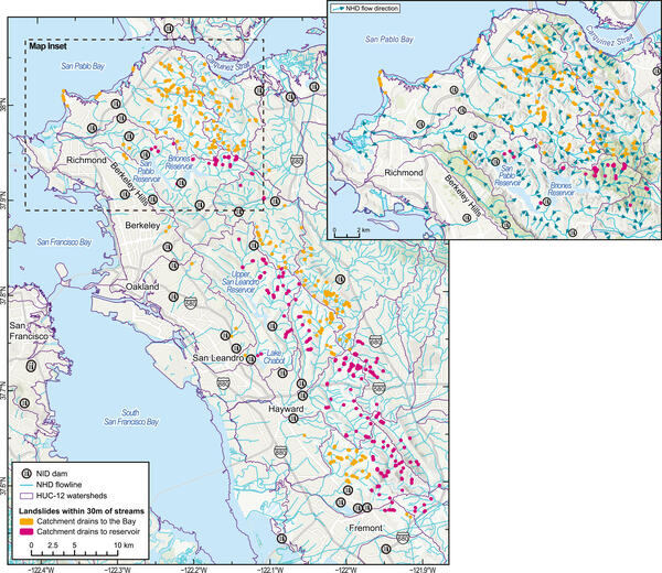
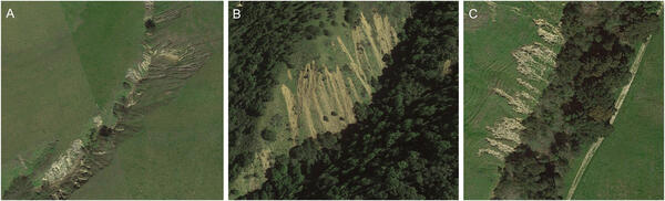
“This research leveraged an intensive mapping effort by Corbett and Collins (with the USGS Landslide Hazards Program) in the 2017 extreme wet winter, when they identified more than 8,900 landslides in eastern Bay Area coastal watersheds,” said USGS Research Geologist Amy East, lead author of the study. “We incorporated that mapping effort into a broader assessment of sediment mobilization in an extreme wet year and compared it to stream sediment discharge, long-term erosion rates for coastal California landscapes, and evaluated whether this type of year (which we may experience again with the upcoming El Nino) does much to counteract sediment deficit in SF Bay as sea level rises.”
The study found that landslides account for most of the long-term erosion rates, implicating extreme wet conditions as an important driver of long (millennial-scale) landscape evolution, but that they accounted for little of the total fluvial sediment discharged into the Bay that year. For the landscape to produce enough sediment to keep pace with sea-level rise, extreme years like 2017 would need to occur in 50 of the next 75 years.
Extreme rain drives erosion, but most sediment stays behind
Steep hillsides are especially susceptible to landslides during periods of intense rainfall. When slopes fail, large volumes of soil and rock can be mobilized and potentially transported downstream.
The study’s inventory of nearly 9,000 landslides provided an unusually detailed picture of how much sediment an extreme wet season can generate. The results indicate that these rare events likely account for the majority of long-term hillslope erosion rates in the eastern Bay Area.
As the climate warms, scientists expect more intense precipitation in many regions, raising questions about whether storms could provide additional sediment to coastal systems that need it.
But the path from hillside to shoreline is not immediate.
Much of the sediment generated by landslides remains stored on hillslopes, becomes trapped behind dams, or sits in stream channels for some time rather than being transported all the way to San Francisco Bay.
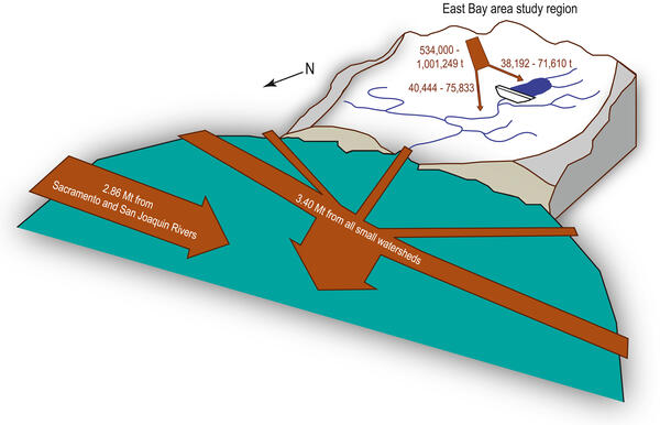
Researchers estimate that only 1%–2% of the newly mobilized landslide material could potentially have contributed to sediment transported by streams into the Bay during the study year.
That lag matters because sediment can remain stored in the landscape for years, decades or longer, before eventually being remobilized and carried downstream.
As a result, even an unusually wet year that produces extraordinary amounts of erosion has only a limited effect on the sediment supply reaching the Bay.
Keeping pace with sea-level rise requires more sediment
San Francisco Bay’s tidal wetlands and shorelines depend on sediment to build elevation and maintain their position as sea level rises. When sediment supply falls behind the rate of sea-level rise, wetlands can become increasingly vulnerable to drowning and shoreline erosion.
The study suggests that relying on extreme wet years alone is not a realistic solution to that sediment deficit.
For the amount of sediment generated during the study’s extreme wet season to meet the Bay’s needs, similarly intense rainfall and sediment production would have to occur in most years—an implausible scenario.
The findings underscore an important distinction between sediment production and sediment delivery. A watershed may generate enormous quantities of sediment during a major storm, but only a small portion may actually make its way to the coast when it is needed.
For managers working to restore tidal wetlands and protect San Francisco Bay shorelines, the results point toward the need for additional sediment sources.
One promising option is the beneficial reuse of dredged material. Sediment routinely removed from navigation channels and other areas could potentially be repurposed to help build and sustain wetlands and shorelines, rather than treating it solely as waste. The U.S. Army Corps of Engineers is exploring this ‘beneficial re-use’ of sediment in the Bay.
For San Francisco Bay, maintaining healthy wetlands and resilient shorelines will likely require working with the watershed’s natural processes while also supplementing them with carefully managed, human-supplied sediment.
RESEARCH ARTICLE: Widespread Landslide Activity in an Extreme Wet Season and Implications for Regional Sediment Management, Eastern San Francisco Bay Area, California
By Amy E. East, Amy C. Foxgrover, Skye C. Corbett, Brian D. Collins, Andrew C. Ritchie
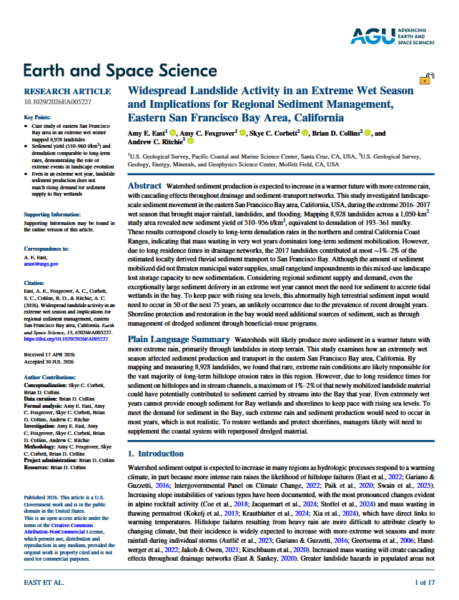 ABSTRACT: Watershed sediment production is expected to increase in a warmer future with more extreme rain, with cascading effects throughout drainage and sediment-transport networks. This study investigated landscape-scale sediment movement in the eastern San Francisco Bay area, California, USA, during the extreme 2016–2017 wet season that brought major rainfall, landslides, and flooding.
Mapping 8,928 landslides across a 1,050-km2 study area revealed new sediment yield of 510–956 t/km2, equivalent to denudation of 193–361 mm/ky. These results correspond closely to long-term denudation rates in the northern and central California Coast Ranges, indicating that mass wasting in very wet years dominates long-term sediment mobilization. However, due to long residence times in drainage networks, the 2017 landslides contributed at most ∼1%–2% of the estimated locally derived fluvial sediment transport to San Francisco Bay.
Although the amount of sediment mobilized did not threaten municipal water supplies, small rangeland impoundments in this mixed-use landscape lost storage capacity to new sedimentation. Considering regional sediment supply and demand, even the exceptionally large sediment delivery in an extreme wet year cannot meet the need for sediment to accrete tidal wetlands in the bay.
To keep pace with rising sea levels, this abnormally high terrestrial sediment input would need to occur in 50 of the next 75 years, an unlikely occurrence due to the prevalence of recent drought years. Shoreline protection and restoration in the bay would need additional sources of sediment, such as through management of dredged sediment through beneficial-reuse programs.
Click here to read this article.

