

California’s climate is changing in ways that challenge our understanding of water management, ecosystems, and infrastructure. From rising temperatures and shifting precipitation patterns to the intensifying extremes of droughts and floods, the state faces a future of increasing variability and unpredictability. Recognizing the urgent need to understand the rapidly evolving science of climate change and its impacts on the Delta, the Delta Independent Science Board hosted an emerging climate science symposium in September 2025 at UC Davis.
 The keynote speaker was Dr. Daniel Swain, Climate Scientist with the California Institute for Water Resources, UC Ag and Natural Resources. In his presentation, he discussed the profound impacts of climate change on California’s water systems, including rising temperatures, increasing variability in precipitation, and the intensification of extreme events like droughts, floods, and wildfires. He highlighted the science behind these changes, the uncertainties that remain, and the critical need for proactive adaptation strategies to address the challenges ahead.
“Sometimes we focus a lot on uncertainties and the challenges that poses for adaptation and management and making plans for the future,” began Dr. Swain. “But I also think sometimes we focus a little too much on the uncertainties, and miss the forest for the trees. We really do know a lot about how things are changing, and although there are large uncertainties regarding the future than we might have thought, the things that we also learned in the recent past allow us to better distinguish between the pieces of our changing climate that we do have confidence in versus those that we don’t. We have a lot of information already about the kinds of changes that we need to be preparing for actively, partly because some of those changes have already begun to emerge.”
The map highlights the extent of Earth’s warming, with data updated through 2024. Shades of orange and red vividly depict areas where temperatures have risen compared to the past. He noted the warming is not uniform across the globe. It is more pronounced over continents than over oceans, and the Arctic stands out as the region experiencing the most significant temperature increases.

“The main reason for this warming is the accumulation of heat-trapping gases in the atmosphere, known as greenhouse gases, that are primarily there because of combustion of fossil fuels and also other human activities, including agriculture,” he said. “ Over the past couple of centuries, the amount of warming we’ve experienced cumulatively to date, since the pre-industrial era, at least when measured on a multi-year basis, was around 1.3 or 1.4 degrees Centigrade of warming. The last two years, 2023 and 2024, and at least parts of this year, have been at least temporarily above that 1.5 degrees Centigrade of global warming. According to current policy plans, we’re on a path toward around between about 2.5 and 3 degrees Centigrade by the end of the century.”
He noted that is subject to climate science uncertainties as well as human activity uncertainties. What will our future carbon emission trajectories look like? Already, that trajectory differs from what was predicted back in the era of the Paris Climate Agreement.
“So there is still uncertainty, but it’s quite plausible at this current juncture that we will essentially double the amount of warming that we’ve observed so far,” said Dr. Swain. “And the impacts from that further doubling of the warming we’ve experienced so far will likely be much greater than the impacts from the first half of that increment, because, as there are parts of the climate system itself that are non linear, but perhaps more to the point, human systems and ecosystems respond non linearly to the warming that we’ve seen and that we’re likely to see.”
Warming temperatures, rising evaporative demand
California has become significantly warmer over recent decades, with a pronounced warming trend beginning in the late 1970s and early 1980s. This increase in temperature is especially noticeable inland and at higher elevations, where the warming has outpaced that of the coast. Although coastal areas are also experiencing rising temperatures, the rate of warming there—especially during the summer—has been slower than in other regions.

Since 2010, there has been record-breaking extreme drought and the worst wildfires in modern history. Around 2010, temperatures in California rose sharply, followed by a prolonged period of elevated warmth. Since then, temperatures have remained consistently higher and have not returned to previous levels.
“We probably are not headed back to where we were before that point specifically,” he said. “This is relevant; even though this summer was not among the hottest, all three of California’s hottest summers on record have nonetheless occurred in the past 10 years, which is not something you would expect to see in anything but a rapidly warming period.”
 The Clausius-Clapeyron relation describes how the atmosphere responds to warming. It’s science that has been understood in its basic form for the better part of two centuries, longer than climate models or even computers have been used to check assumptions.
The basic idea is that the air’s capacity to hold water vapor—technically called the saturation vapor pressure—increases exponentially with a linear rise in temperature, explained Dr. Swain. This process is a key driver of California’s climate, influencing both extreme wet and dry conditions. Global warming intensifies this effect, creating a thirstier atmosphere that holds more water vapor. He pointed out that this isn’t just a theory—it’s backed by climate models, real-world observations, and instrument data.
In short, as the air gets warmer, its ability to hold water vapor increases rapidly, with significant impacts on weather and climate patterns.
 To illustrate this concept, Dr. Swain and his colleagues use an analogy of the expanding atmospheric sponge. Think of the atmosphere like a sponge that can hold water. At any given temperature, this “sponge” has a certain capacity to absorb moisture. Now, imagine that as the temperature rises, this sponge doesn’t just grow a little—it grows a lot. For example, with about 3°C (or 5°F) of warming, the sponge becomes roughly 22–23% larger. That’s a substantial increase.
This means warmer air can hold much more water when moisture is available. But it also means that when the air is saturated—like a soaked sponge—it can release much more water, as if you were wringing out a bigger sponge. So, as temperatures rise, the atmosphere becomes “spongier,” with a greater ability to both soak up and dump water, depending on the conditions.
“In practical terms, it raises a ceiling both on how intense precipitation can become when conditions are favorable for rain or snow, but also on how intense evaporation can become most of the rest of the time,” said Dr. Swain. “So you see an accentuation of both precipitation extremes and evaporation, or at least potential evaporation extremes, limited only by there being water available to evaporate in the first place. So in practical terms, heavier downpours, but also greater atmospheric thirst, the net effect being something we term increasing hydroclimate whiplash.”
California’s variable precipitation
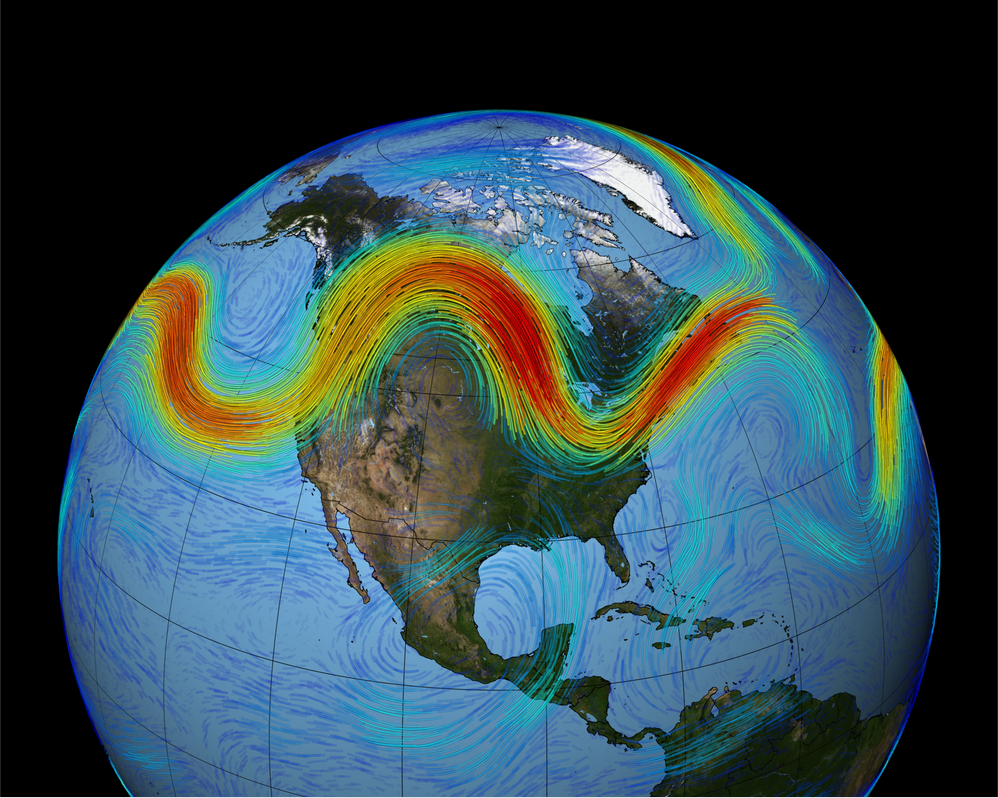 California’s climate naturally swings between wet and dry because it sits in a unique spot—a transition zone between the calmer, more stable subtropics to the south and the much more active, stormy mid-latitude temperate zone to the north. This location puts California right on the edge of the jet stream, a fast-moving river of air in the upper atmosphere that guides storms—the jet stream shifts with the seasons, which is why California’s rainfall is so seasonal.
In the summer, much of the state, especially the coast, gets little to no rain. Then, as fall arrives, rainfall gradually increases, peaking in winter before tapering off again in spring and returning to dry conditions in summer.
This seasonal pattern is driven by the jet stream, which follows a similar cycle. From fall to winter, the jet stream strengthens and shifts southward, bringing California under the influence of the more unstable, stormy mid-latitude climate. As spring transitions into summer, the jet stream weakens and moves northward, allowing the more stable, subtropical conditions to dominate California’s weather. This shift explains why California experiences such distinct wet winters and dry summers.
California’s rainfall patterns aren’t fixed or predictable, which is a big reason the state is so vulnerable to drought. Unlike other regions, California relies almost entirely on a single winter wet season. Summers are typically dry, so if the state doesn’t get enough rain and snow during the winter, there’s no backup until the next wet season rolls around.
 Adding to this challenge is the behavior of the jet stream, which varies significantly from year to year. While California’s precipitation follows a strong seasonal cycle, the jet stream’s position and strength can shift dramatically. In some years, it’s stronger and sits farther south, bringing more storms and a wetter winter. In other years, it’s weaker or positioned farther north, leading to much drier conditions. These shifts in the jet stream create huge year-to-year swings in California’s water supply, giving the state the highest variability in annual precipitation of anywhere in the continental U.S.
“If this map were extended to all of North America, California would be pretty unique even within the rest of North America as well,” said Dr. Swain. “So California really does have a more variable hydroclimate than certainly most places that in the United States, but arguably than most places even in the world.”
Hydroclimate whiplash
In California, notably, there’s not a massive trend in the average annual precipitation on a statewide basis, but there is a detectable increase in the statewide moisture variability, or hydroclimate whiplash. There’s also a strong trend towards increased drought frequency and severity, occurring in an environment where precipitation has not decreased by a similarly robust or sustained amount.

The slide shows pictures from Butte County, as we’ve gone back and forth from dry to extreme wet to extreme dry to extreme wet. “This is hardly limited to Butte County, and it is an illustration of the kind of variability that we’re talking about here in terms of extreme swings between wet and dry and all the consequences that come with that.”

Climate science research suggests the average precipitation in California may not be the most important metric to be considering in a warming climate, partly because of the uncertainty; it’s not really known whether California’s average precipitation will increase or decrease, and indeed, thus far, it really hasn’t done either in a significant way. Yet, those very same climate models that predict small and or uncertain changes in California’s average precipitation show a significant increase in the wettest wets and a slightly lesser increase in the driest dries when it comes to precipitation alone.

“We expect to see, even where the average precipitation could increase or decrease, we don’t really know, but the tails of the distribution on both ends will likely be broader,” said Dr. Swain. “That leads to an increase in the interannual variability of precipitation beyond even the already high levels that we see now, what we call increasing precipitation whiplash.”
 “This sets the tone agriculturally, ecologically, and even in terms of the daily rhythm of life in California; we have wet winters, dry summers, and some transition seasons in between. But there is some evidence that those transition seasons may become a bit drier and that the winter may become a bit wetter on average, further accentuating our already fairly dramatic seasonal cycle. That has pretty significant implications for agriculture, as it would increase the length of both the growing season, but also has huge implications for things like wildfire risk and the health of ecosystems, and in particular in autumn, which is peak flammability season in California, after our long, dry summers, and critical from a water supply perspective.”
The implications for snowpack, particularly in the Sierra watersheds, include a later start and an earlier end to the snow accumulation season, and potentially more intense runoff during the rainy season. He noted this is not necessarily a reflection of temperature.
“Rising temperatures, of course, will further shift our snowpack, but this is just a reflection of the seasonal shift in the actual arrival and departure of precipitation itself, amplifying those changes in snowpack that we expect to see from temperatures,” he said. “We don’t really know what’s going to happen with California’s average precipitation, but there’s pretty high confidence that the variability both within seasons, so even week to week, month to month, within winter and then from season to season, will probably increase, even as we can’t really give with confidence a statement about what might happen on average.”
Floods
 When it comes to the extreme wet, the wettest ones are usually atmospheric rivers, these narrow corridors of highly concentrated atmospheric water vapor that can bring enormous amounts of water into California. When those plumes of extremely concentrated moisture hit California’s coastal mountains or the Sierra Nevada, the air is raised by the topography and often falls as very heavy precipitation.
“This is a key piece of California’s water supply, but also the primary cause of California’s major flood events, and we expect these events, especially the most intense ones, to become considerably more intense in a warming climate because of that expanding atmospheric sponge effect that will eventually lead to the occurrence of atmospheric rivers of unprecedented strength. Again, we don’t necessarily know whether we see more atmospheric rivers overall or not, but we are saying specifically that the most extreme ones will likely become more so.”
 The great flood of 1862 was a flood of such magnitude that hasn’t been seen since the advent of modern water infrastructure in California, but the paleoclimate record suggests they happen every century or so. So they’re unusual in recent times, but far from rare in geological timescales.
“A modern-day repeat, suffice it to say, would be pretty disastrous for modern California, and we expect that there’s a considerable increase in risk with a warming climate. In fact, we looked at this pretty directly in a study in 2022 as part of the ArkStorm 2.0 project, we found that the risk of a very large flood event, potentially even of a magnitude of an 1862 like flood, has probably increased significantly already, perhaps doubling in the background, in a period where we’ve actually experienced a lot more extreme droughts than we have severe floods.”

Recent research suggests that natural climate variability has overridden the human-caused warming signal in its effect on flood risk in California over the past couple of decades, effectively masking the background increase in the risk of a significant flood event. That probably won’t continue forever. Recent research suggests that an 1862-level event is potentially more likely than not over the next 40 years or so, which is partly a reflection of what the cumulative risk of relatively unusual events is over any 40-year period, plus the effect of climate change.
 The winter of 2022-2023 was exceptionally wet, ranking among the wettest on record, thanks to a series of atmospheric rivers that led to flooding and storm damage. When compared to the ARkStorm scenarios, precipitation during December and January reached 80% of ARkStorm 1.0 levels and 50% of ARkStorm 2.0. However, the rainfall was spread out over a longer period and more evenly distributed. Now, imagine if the rainfall had been double and the temperatures significantly warmer during December and January—that’s the level of extreme flood scenarios being considered.
 Beyond precipitation itself, there’s the question of rain versus snow; there will likely be a dramatic shift toward more rain rather than snow, with significant implications for runoff, particularly in the Central Valley and in the watersheds most proximal to the Delta. The runoff increases very strongly in the San Joaquin basin, particularly during the most extreme storms, with peak runoff increasing by 300-400%.
“These are not incremental changes,” said Dr. Swain. “This is effectively during the most extreme runoff events with a couple of degrees of warming, potentially a novel regime, and all of that is ultimately flowing into the Bay Delta.”
 Droughts are worsening, primarily due to the dry side of the ‘expanding atmospheric sponge, and the same amount of rain or snow just doesn’t go as far as it used to. This leads to a scenario in which the most extreme precipitation events are expected to increase substantially in a warming climate. That signal is a little bit elusive, but it is expected to emerge eventually.
“What it might mean in terms of flooding is that we actually have decreases in runoff for weak to moderate flood events, which might lead us to a false sense of security about the most extreme flood events, which we actually think might still be increasing at a greater rate than the average extreme precipitation because of that double whammy effect of warming temperatures and the snow to rain conversion, as well as more extreme precipitation to begin with. So consider the five and 10-year recurrence intervals at your peril, because it’s really the 50, 100, or 200-year recurrence interval floods that cause the most problems, and those might be doing something very different than the kinds of floods we observe more frequently.”
Wildfires
 We know that increasing aridity means greater flammability of vegetation and more intense fire on the landscape; this is already reflected in shifts towards much drier, much more active fire conditions overall.
“Regardless of future climate trajectory, there is going to be some further warming, and this is something that’s probably going to get considerably worse before it gets better. So we really do need to engage in short-term adaptation and interventions over the next few decades to get ahead of what has become a pretty significant crisis in California for a variety of reasons.”
From a Delta perspective, changes in post-fire runoff patterns can result in stronger runoff for several years. Water quality is also affected because ash and debris can flow into reservoirs, posing problems for turbines and water quality.
“But even downstream of that, you have increased turbidity, you have sediment, and you have ash that might be in the water that wouldn’t have been there otherwise.”
Uncertain: California’s average precipitation
We don’t really know what’s going to happen with California’s average precipitation. This mainly comes from the fact that what we know the expanding atmospheric sponge raises the potential for the wettest wets, but the driest dries, precipitation-wise in California, are primarily dictated by atmospheric circulation, or essentially changes in atmospheric wind patterns over the North Pacific. We don’t know exactly how those will evolve.
 “Climate models have long said that there would be an El Niño-like trend in the tropical Pacific, but what we’ve actually seen through 2025 is that there’s been a La Niña-like trend. So essentially, we’ve seen the opposite trend of what climate models predicted. And there’s been a lot of research looking into why that might be, what the implications might be, what’s driving this? Are we just unlucky? Are we in a weird iteration of internal variability, or is this something that climate models are actually wrong about? It would be pretty consequential if they were.”
Complicating things further is a paper published this summer, that suggested what was previously thought to be a natural trend in the Pacific Decadal Oscillation, another mode of multi decadal variability in the Pacific Ocean that affects California precipitation and climate quite substantially, is in fact, actually at least partly caused by greenhouse gas emissions and also other pollutant emission trends like aerosols from South and East Asia,” he said. “This means that the unexpected La Nina-like trend, which is also related to the trend towards an increasingly negative flavor, if you will, of the Pacific Decadal Oscillation, might itself be a reflection of climate change, and climate models did not necessarily represent that correctly.”
He acknowledged it’s a lot of very complex science compressed into a very short period of time. So the important takeaway from this is that there are already significant uncertainties about how El Niño, La Niña, and the Pacific Decadal Oscillation might change, with pretty substantial implications for California precipitation.
“One key implication is that if this ends up being true, future drought risk, which is already a major concern, has actually been underestimated.”
From a climate adaptation perspective, does this throw a wrench into our planning? Dr. Swain said no. “If we keep our focus primarily on the wet and the dry extremes, rather than trying to define exactly what’s going to happen with California’s average precipitation – because we honestly don’t know – the fundamental driver of that expanding atmospheric sponge is still going to dictate what happens with the very wettest wets and the very driest dries. And I think we can plan to prepare accordingly.”
Sea level rise and the Delta
 There is observational evidence that sea level rise, another non-linear process in a warming world, has accelerated, approximately doubling in the past 30 years. Dr. Swain said this is not unexpected and is mainly in line with what has long been predicted.
Interestingly, in the San Francisco Bay Delta, if you look at where the actual sea level rise is mainly arising from that we’ve seen or expect to see later this century, more than half of it directly comes from the melting of continental ice sheets in Antarctica and Greenland, as well as mountain glaciers. It’s not necessarily meltwater from the glaciers, but it is the net effect of all the things that are changing, including Earth’s gravity, because as the massive ice sheet water shifts to the oceans, it measurably changes the distribution of mass on Earth.
Much of the sea level rise that will occur locally in the Delta is the product of remote processes in completely different parts of the world, particularly the frozen regions. Changes in deep-ocean currents also affect sea level rise, adding to the scientific uncertainty. As a result, it is still possible that sea level rise could exceed the most widely accepted estimates.
This is one of the larger challenges for climate adaptation in the Delta, because there is a considerable non-zero chance that sea level will rise over the next 30 to 50 to 70 years, depending on the relevant planning horizon. It could end up above the high end of the reasonable median estimates that we’re seeing right now.
“It is very difficult to put numbers on this currently, because we don’t know that much about exactly the ice sheet dynamics that are relevant for the Delta,” said Dr. Swain. “This is a classic case of ‘what happens in the Arctic and Antarctic doesn’t stay in the Arctic and Antarctic.’ The most dramatic example of that might well be with respect to sea level rise in places like California and in the Delta.”
This has significant implications for flood risk because higher sea levels increase pressure on levees, so it takes a less extreme storm to result in freshwater flooding. However, he noted that we already have issues with saltwater intrusion for water supply, ecosystems, and the permanent infrastructure being contemplated for this part of the state, as well as all the practical decisions involved with deciding what standards to build to, where it should be built, or whether it should be built at all.
What to expect in a warming Delta ….
 We expect increased precipitation intensity and overall aridity, a significant loss of mountain snowpack, and a contraction of the snow season, with more extreme heat and faster runoff. Think increased variability and increased whiplash as the clearest, most specific signature. The driest dries will be still drier than even what we’ve seen so far, but the very wettest periods, which we haven’t quite seen this much yet, will likely not only be as wet as they ever have been, but probably even wetter.
That’s a blessing and a curse, depending on the context, because it means we will still get water; it’s just going to come in potentially larger, more inconvenient bursts, which is better than not getting any water at all, since we will still have water to work with. We’re going to have to learn to manage it arriving in increasingly inconvenient ways, so this points to the need for flexible, flexible, and proactive interventions and adaptations commensurate with these physical realities.
 That can mean things like nature-based solutions and high-tech interventions. So we’re thinking about restoring floodplains, as well as things like Flood-MAR aquifer recharge and forecast-informed reservoir operations that help us manage this whiplash, this variability. It means improving public and agency awareness of risks and interventions through scenario-building and response exercises. It means stress testing that covers the full range of plausible extremes, considering the real needs of the system and its weak points.
“My real message here is, despite all of the maybe scary things I’m talking about today and all of the uncertainties I’ve pointed out, I don’t think any of this is a reason that we should succumb to decision paralysis, because we actually do have a lot of information about where we’re headed,” said Dr. Swain. “We know that sea level rise is occurring, and we know that we’re going to see worse droughts and probably larger floods. Those statements alone should give us enough information to be preparing in the right direction. There will be win-win interventions that can exist even in the absence of climate change. This is a moment where, at least in some circles, it’s become more challenging to talk about climate change. But there are interventions that benefit people, communities, and ecosystems even in the absence of climate change. There are interventions out there that would be just so broadly beneficial that climate change is only one of many motivators to pursue them.”
During the Question & Answer period, Dr. Swain was asked to expand on the win-win solutions.
“We’ve already seen plenty of extreme droughts in contemporary history in California, so there’s a long history going centuries back, especially of major floods, that already would justify a system that is even more capable of dealing with more extreme droughts and floods, even if there were no long term trend, simply because we know that what we see in the 20th and early 21st Century is not the full range of what could have been experienced even before there was any climate change. So there’s a reason why this would be beneficial for people, for ecosystems, and even in the absence of climate change.
 That’s true for forecast-informed reservoir operations, which leverage our increasingly accurate weather predictions that we have to more effectively know that we don’t need to dump that water right now from the dam; we can save it in case we need it for the drought, or that there is a huge storm is coming, so it would be dangerous to hold it. We need to start releasing that water now. It allows us to reoperate existing infrastructure without huge capital investments and in a way that will enable us to have more resilience to floods and droughts. We have more efficient water use and better risk reduction wrapped into one, and that benefits people and the environment as well.
It’s also thinking about Flood MAR, for example, so coupling the opportunistic use of flood flows for groundwater recharge. In the moment of a flood, there are two benefits you’re potentially achieving: flood risk reduction by shaving a bit off the peak of the flow from the flood, and groundwater recharge, which is actually increasing resilience to some future drought. So while you may not be worried about water scarcity during a flood, you need to be thinking about both flood and water scarcity at the same time. So, Flood MAR reduces both flood and drought risk, potentially simultaneously. And depending on how you do it, it’s also a major environmental and ecosystem win as well. And so here you have something that could potentially be useful, even if there was no change in flood or drought risk.
FOR MORE ON THE DISB EMERGING CLIMATE SCIENCE SYMPOSIUM

