

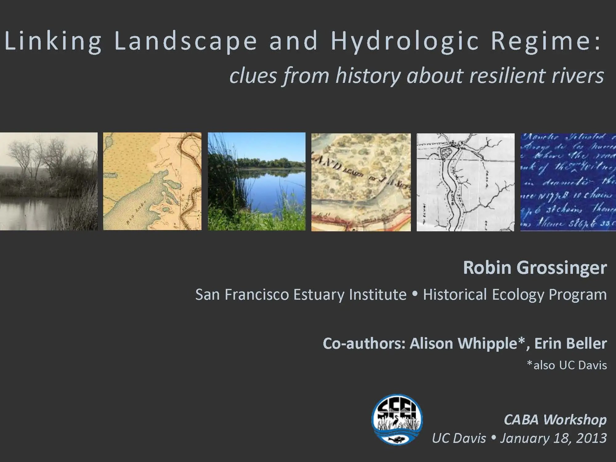
 Robin Grossinger, Senior Scientist at the San Francisco Estuary Institute, began by saying he felt well-set up by the first two presentations. “I think they both addressed straight on the paradox we find ourselves in, which is that we know that we can’t restore the past, we can’t recreate the historical conditions that these rivers experienced, and yet we know equally that we need to reestablish more natural – as nature intended – hydrology and morphology, and so we find ourselves in this impossible situation,” he said. “But they both presented creative strategies, taking clues from the past in terms of hydrology, in terms of morphology, and creative ways those can be brought into our systems today. And I think implicitly, I agree with the idea there’s a lot of room for improvement, even within the dramatic constraints that we face. That’s what I think is exciting.”
Mr. Grossinger said his presentation is going to delve into the interrelated aspect of riverine landscapes and wetland landscape with the hydrograph or hydrologic regime. “I think historical research is helpful because it can help us illustrate some of those connections as we really don’t talk about both in the same breath typically. We talk about hydrology and we talk about restoration but those are two different agencies usually, or groups in agencies; they are different researchers with different research trajectories in communities, and so I think that’s part of the reason we don’t tend to connect these things which are obviously critically intertwined – reciprocal, even.”
 “I think the other reason we don’t talk about them together is that we don’t see it,” he continued. “We don’t have the visual experience of interconnected riverine and wetland landscapes. They’ve been gone for a century or more.”
Mr. Grossinger then gave a quote from one of his favorite publications written by Dr. Petts called, ‘The Historical Change on Large Alluvial Rivers’: “It says as I agree, ‘improved understanding of hydrosystem dynamics resulting from [historical analyses] mainly to improve methods for the restoration of damaged systems.’ Really it is clues, it is insights. It’s not a literal translation into the future; the future is going to be complex. But clearly the present doesn’t give us all the tools either. And we may learn something useful from how these systems used to work.”
Mr. Grossinger then gave the three main themes of his presentation:
1. The flow regime was expressed through the landscape, in terms of its making riverine and wetland landscapes, but then it was also modulated by and reshaped through groundwater discharge, flood basins and floodplains, slowing down and speeding up, adding, subtracting, changing the peaks. “So really it’s a back and forth relationship and they are really intertwined.”
2. The historical Delta was a place of extreme hydrologic variability (seasonal, interannual, decadal) expressed across a relatively stable geophysical template. “The Delta was a place of incredible hydrologic diversity at all these different scales, but I’m often impressed how stable, arguably, the geophysical landscape was. People often think everything was moving around a lot: the rivers were moving, the channels were moving, the lakes and ponds – most of those things were relatively stable. Somewhat low energy, low gradient environment with cohesive soils. The river levees were in position for thousands of years. The channels didn’t move a lot. So I think there is some combination of this stable and very complex morphologic pattern upon which you’re expressing incredible diversity of flows, depths, inundations, it’s translating into a lot of variability of life history pathways, of opportunities for different species to take advantage of different water years and timing.”
3. This translated into the resilience of the historical Delta: ability to respond to hydrologic variability in a complex way that translated into ecological productivity, connectivity, refuge, etc. “I think this translated into the resilience of the system and it’s ability to respond to the incredible diversity, especially our landscape and the California Mediterranean climate where there is no average year. An average hydrograph that translated into incredible productivity, connectivity, refuge, all those sorts of things.”
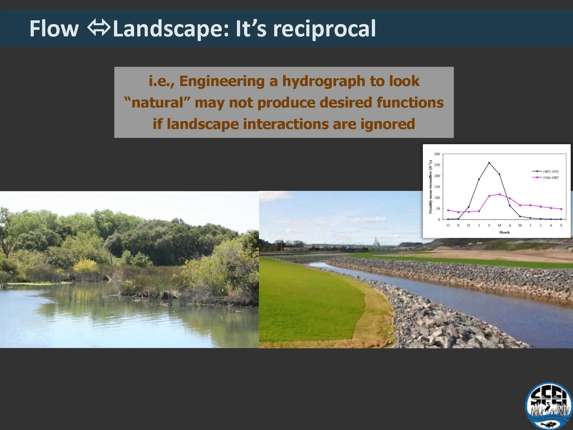 Mr. Grossinger said the challenge is that we could potentially create a perfect hydrograph that creates a really diverse set of peaks in different years, but if it’s not expressed across a landscape – a functional landscape – it’s not going to produce what we expect it to ecologically.
“We could just do it through engineering, but if it doesn’t have the recipient reciprocal relationship, I don’t think it’s going to make what we want.”
He then gave two examples.
Example 1: Inundation patterns: expression of flow variability across the landscape
The first example looks at inundation and how floods and high flows were expressed through the landscape. This draws on the work done by SFEI on the historical mapping of the Delta. “We’ve recently tried to (with a varying a degree of success) add a third and fourth dimensions to that historical data set, so we actually do have quite a bit of data that Alison Whipple compiled of different depths of flooding at different times of the year in different years, and a lot of descriptions about it. It was such a phenomenon. So we tried to compile that.”
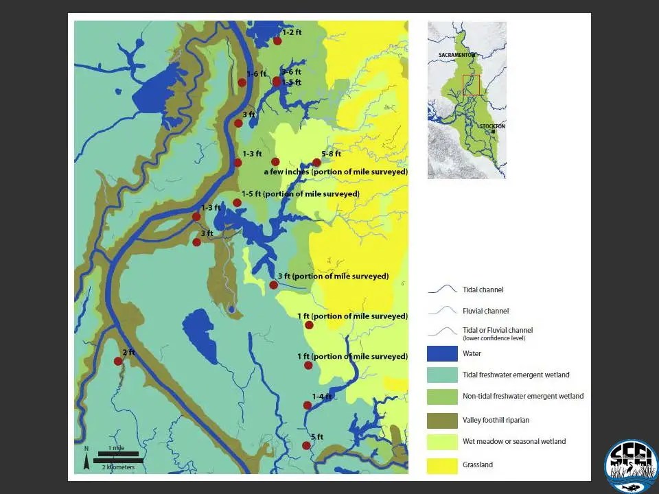 Much of the Delta was tidal; at least a few days a month, a massive area flooded was by the spring tides. “That was probably really important for connectivity, for delivery of nutrients from the marsh to the aquatic system,” he said. “But then getting into the fluvial component, there were these flood basins – the sort of Delta component, the downstream end of them – entering into the Delta. There were massive areas of flooding. These are on the order of 100,000 acres or more in the northern Delta. Pretty impressive depth, set times, often 4, 5, 6 feet for months and months and months. For long periods of time. Then similarly, in the San Joaquin coming from the south – although quite a bit later because of a greater proportion of snowmelt signal, and maybe a little bit shallower.”
In February in an average year, there was also the component of temporary flooding, which is more event driven, coming in from the major tributaries, that would add flooding again on the order 10-20,000 acres, which would add to ecological functions, although not as deep and not as long lived, he said.
“Then interestingly, in a month such as May, you might get both of those giant watersheds turned on and spreading in a massive area of flooding though the Delta and then actually the Sacramento typically would fizzle out while the San Joaquin is actually peaking, creating this really bizarre phenomenon of the hottest part of the Delta, really sort of the hot and dry Central Valley experiencing these giant floods,” he said. “People really commented on how strange that was to have these floods when it felt like middle of the summer, which it was. So think about how important that would have been for native species to have that input of cold flood waters relatively late in the season.”
 With that, the researchers started to cobble together the contemporary flooding picture to compare. The most functional element of complex hydrograph-landscape relationship that we have today is the Yolo Bypass.
“This is flooded for a fairly short duration. Typically the Yolo Bypass floods for just days or maybe even a few weeks at a time, so it’s really more equivalent to the short term flooding we had on the margins of the Yolo Basin. It’s very different from what we had historically. It’s really arguably somewhat of a shadow of that process, and yet it’s the best thing we have probably.”
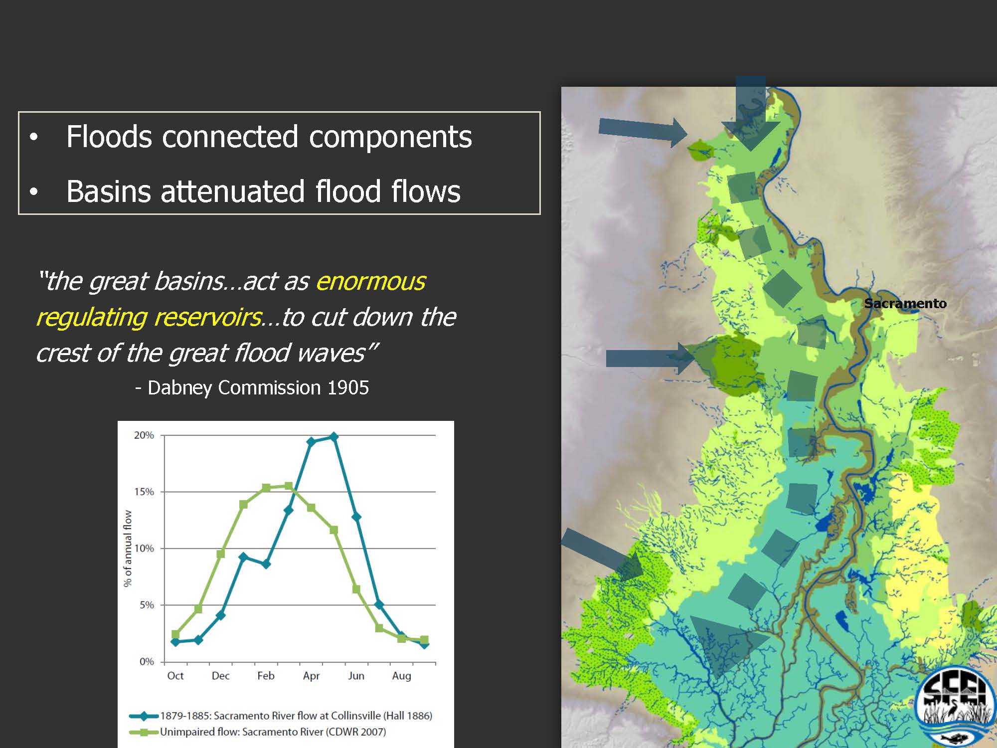
He then turned it around, looking at the flood basins from the perspective of how they mediated the hydrologic regime. “There was this fascinating effect that there were two courses for river flows down the Sacramento River. There’s of course the channel coming down the main stem more quickly, and then there was a lot of water, in many years half or more, going down the flood basin. Those basins had the effect of connecting the landscape and also attenuating the flows themselves. The basins act as enormous regulating reservoirs to cut down the crest of the great flood waves. The chart compares the calculated unimpaired versus the actual flow in the 1880s, you can see how much later the peaks were because of these effects of floodplains, flood basins, and groundwater recharge really changing the shape of that curve.”
There were a lot of ecological effects as well. “The water that was coming off of the flood basin, was talked about as being impregnated with decaying vegetable matter, really full of organic matter, and then species, too. Small fish were going up into these areas and they were able to read the receding hydrograph and follow them back out.”


There was also the phenomenon of late summer inflow. The retention of water in these basins would let a freshwater into the Delta through into the summer. “Gilbert and other researchers commented on it,” Mr. Grossinger said. “It was quite a phenomenon, distributing their discharge over a longer period than if the river were confined to its channel. So thinking about the significance of that function for the system and thinking about what are the elements that were important to the system, and what’s desirable. The next question is what is possible; what is practical at what scale.”
Example 2: The Santa Clara River
The second example is from the Santa Clara River, a river in Southern California, which is on the dry side of the spectrum. Resilience refers to the ability of the systems to deal with particularly environmental variability, as well as all the other stressors while continually maintaining functions, as well as cope with novel situations without losing options for the future. We need to specify what the functions that we care about, such as fish runs and riparian forests, Mr. Grossinger said.
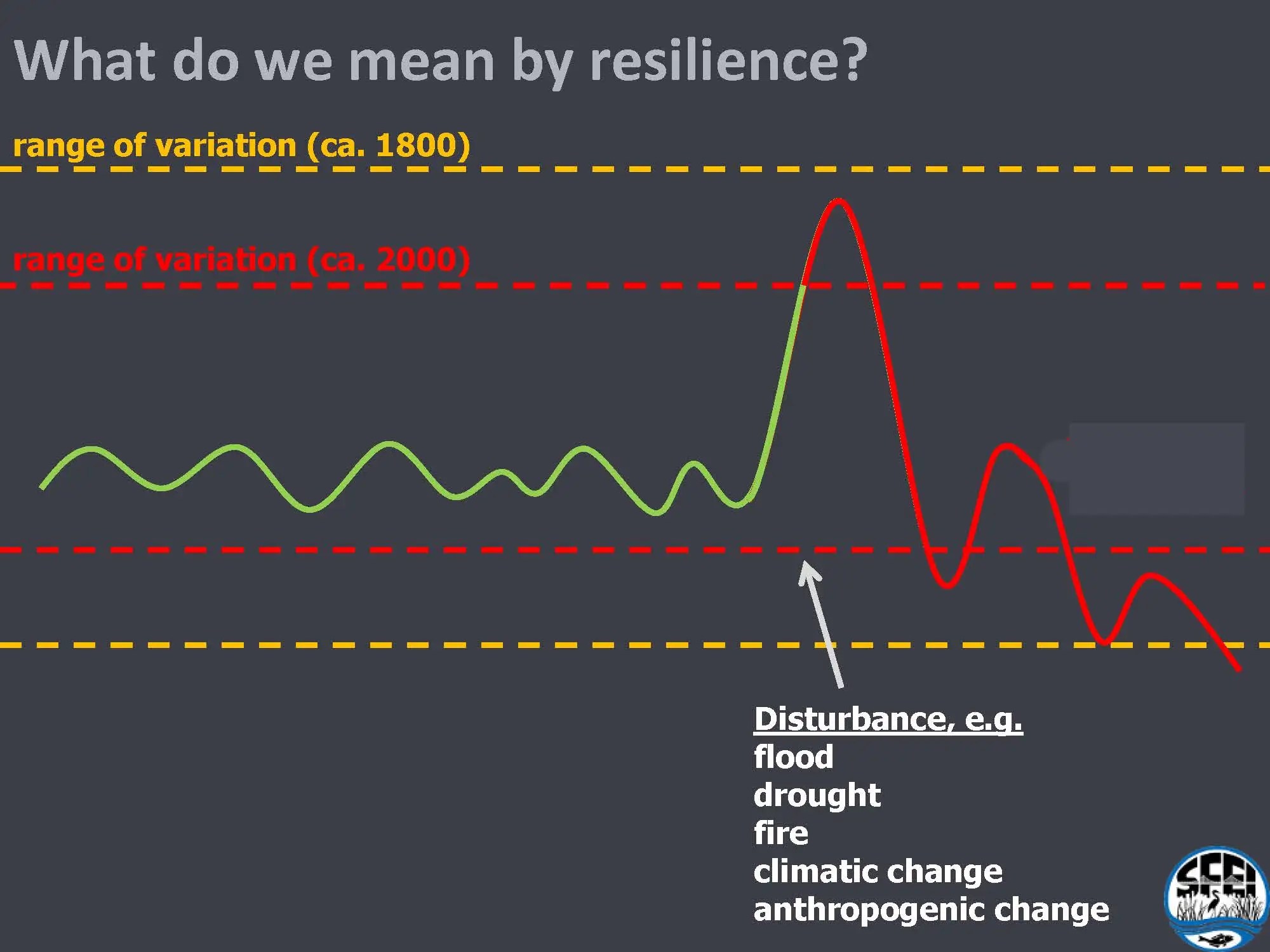 He presented a simple graphic to illustrate the point. “Environmental conditions vary through time and then there will be a disturbance: an extreme event, a flood, a drought, and fortunately different ecological functions or processes have the ability to usually tolerate those within a certain range of variation,” he said. “The steelhead run might not be that good that year, but it recovers in the next year. The riparian forest gets somewhat wiped out but it comes back. The system adapts to changes, but it doesn’t turn into something completely different or go extirpated.”
The challenge today is that the amplitude of this variation is getting bigger with climate change, he said. “Although in fact it may have gotten smaller in some ways than in the previous hundred years as we’ve reduced flooding, so it some ways it may be going back to normal for some things – well maybe not normal, but more of a range.”
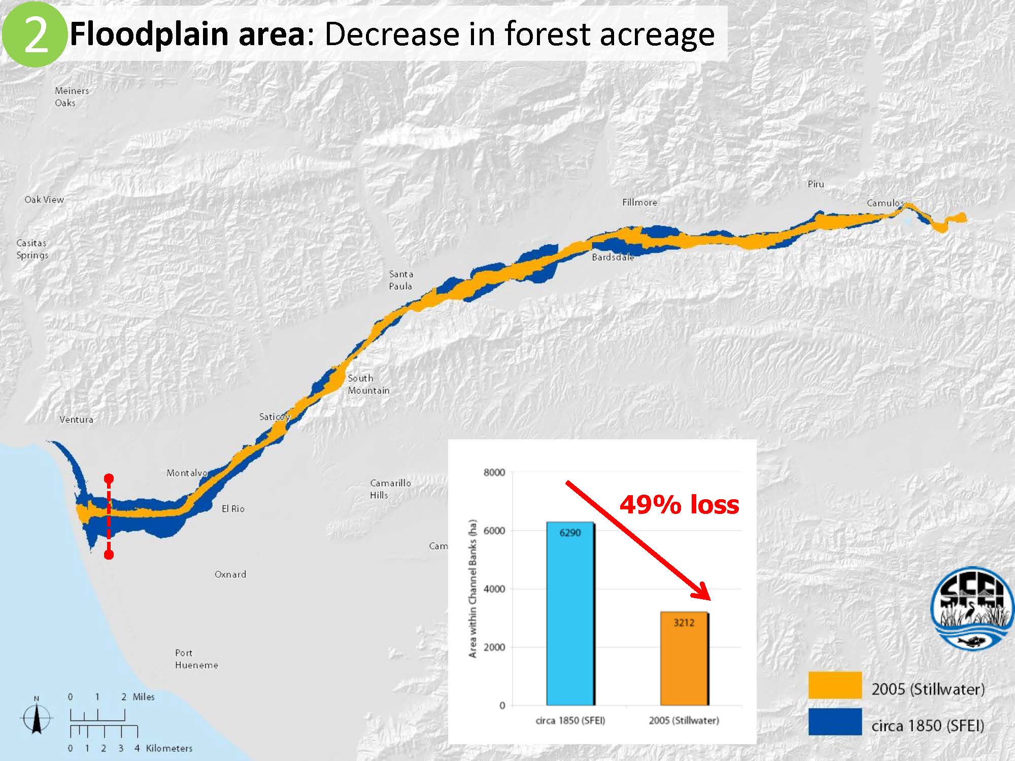
But the other challenge is the narrowing of tolerance. “The systems have to deal with broader variation while they have less tolerance, we’ve made them more sensitive. To me, that’s a positive thing in that we’re going to have trouble dealing with climate change locally, but we actually do have the ability at least in theory reduce the range of tolerance, reduce the sensitivity of our systems. That’s something we actually could do. Particularly, when you look at systems from a historical perspective and see that we’ve lost roughly 99% loss, 95% loss, 99.9% of certain characteristics, so often if we get back 5%, 10%, 40% is really quite bold.”
The literature says that the things that are important for resilience are complexity, diversity, heterogeneity, connectivity, refugia, scale, and functionality. “Those concepts are great and probably true, but they don’t mean anything in the abstract, they are sort of platitudes, and in fact they are somewhat contradictory. … So what did they actually look like in our systems?”
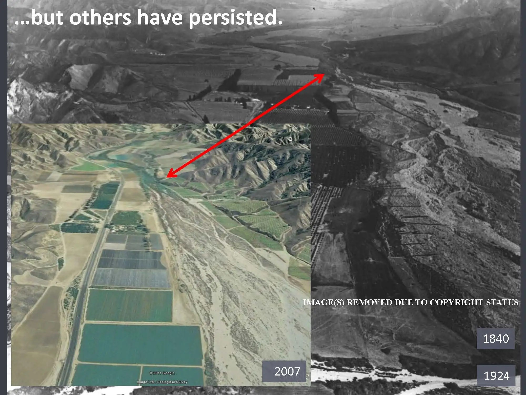
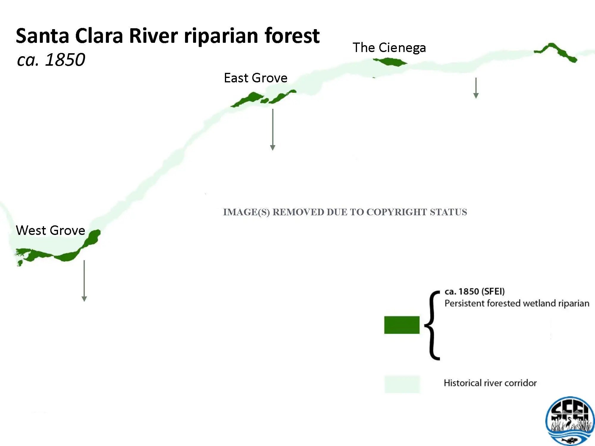 Mr. Grossinger used the example of the Santa Clara River, presenting a map showing the riparian forests. “It’s a fascinating example of longitudinal, morphological diversity and hydrologic diversity and their intertwined nature,” he said. “These patches are important for a rare bird species but they are considered very fragmented, and looking at the map, you’d think they need to be connected up, this is a fragmentation problem. Our historical research found that actually they were fragmented historically. There were nodes of ecological diversity, riparian forests in certain patches such that they even had names: East Grove, West Grove, and Cienega which means marsh.”
The riparian forests were very distinct from the intervening reaches which were braided, open, and almost unvegetated or only had alluvial scrub. The riparian areas were really wetlands; they had wetland plants, willows, cottonwoods, mature forests; there was really incredible diversity along this relatively dry land river, he said. These forests persisted through time; they are mentioned as far back as 1840 on a Spanish maps, and through the decades in various quotes.
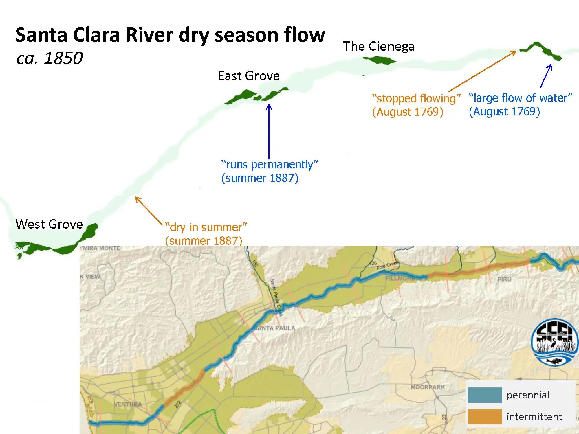 “These features are persisting through time at a pretty remarkable scale and why is that?,” said Mr. Grossinger. “It turns out also we found evidence that there were the perennial reaches of the river, and that those were very persistent through time. We affirm by documents from different centuries and different seasons, and that the intervening reaches were also very dry consistently. So we were able to make a map and see how that relates to how that controls these features, so the hydrologic diversity, that different flow regimes, and it’s related to the underlying geologic form of the valleys widening and narrowing. Something that’s actually hard to mess up, it turns out. Despite all of our efforts.”
Mr. Grossinger said that the fragments turn out to be not longitudinal fragments, but lateral fragments. “They are smaller than they were, but they are in the same places,” he said. “The nodes actually persist. The nodes of ecological diversity, the complexity, but they are just smaller. And they actually match contemporary nodes of rising groundwater, so that aspect has remained intact, interestingly enough.”


“Before we did this study, a lot of people had argued that this river used to be perennial, and that was the problem, but that’s not the problem. In fact those controls are relatively strong. The problem is actually the recipient landscape, arguably, adjacent to those flow regimes.”
 He presented some photos to show how persistent some of the controls are, pointing out that while the hydrology has stayed intact, the landscape around it hasn’t. The floodplain has been reduced, especially in those nodes. “We did an artist reconstruction of what those looked like and you had these remarkably wide riparian forests which had mature trees, 60, 80, 100 years old, complex, overstory and understory and you also had these broad, sandy, high-energy floodplains. And you can imagine how much those were able to dissipate floodwaters. It’s a very flashy, giant river. One of the most flashy in the world, and so how this acted as a bit of a shock absorber, allowing this area to persist over longer term. Gain some age and complexity.”
“The challenge we have now is that this area is confined into a very small corridor, and so those patches of riparian forests are reset really frequently,” he said.

“A lot of these things come and go, but that’s because we’ve actually increased the sensitivity of that system to the same flow events,” Mr. Grossinger said. “If you look forward, the models suggest that 25% bigger flood peak in 2050. And so this area then has to deal with increasing amplitude as well as decreased tolerance.”
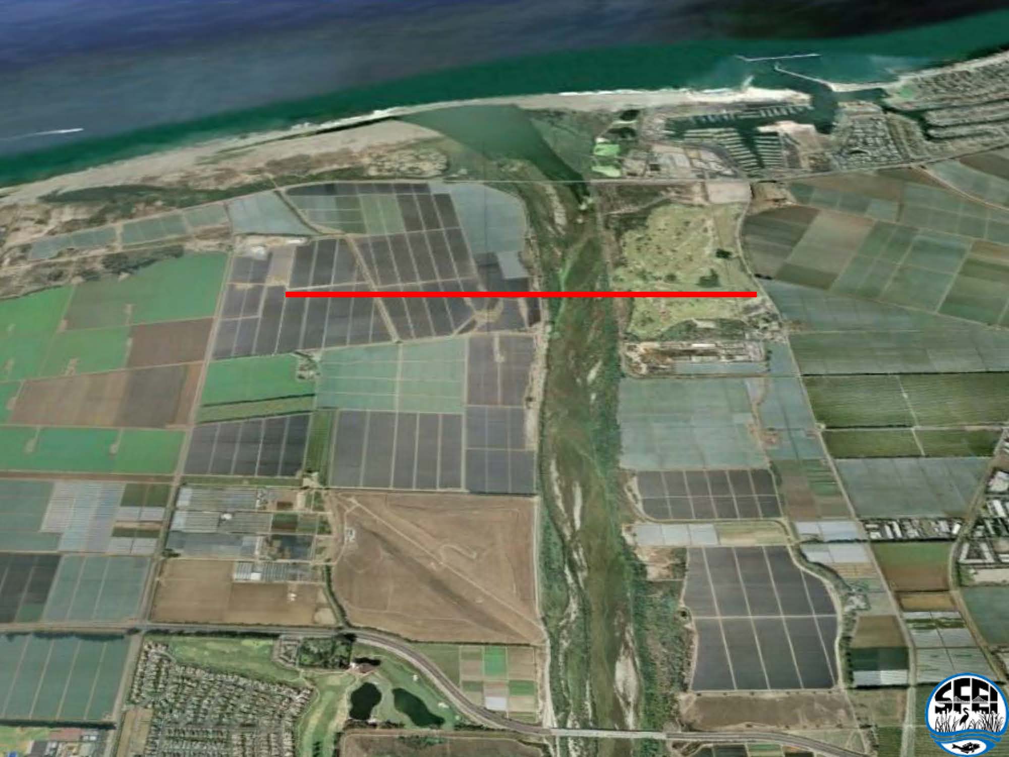 He presented a picture of the river as it is today. “It’s a relatively natural looking system, but the red line is how wide it was historically,” he said. “What I think has happened with the disconnection of flows from the landscape is that it has reduced the resilience to both droughts and floods. To floods, because there’s not that shock absorber; there’s increased concentration of energy in a small area. To drought because the naturally perennial reaches that are still maintaining their characteristic, they are not expressed over a large area as they could be to provide a right amount of area and function.”
Mr. Grossinger ended with a note that the Coastal Conservancy and the Nature Conservancy are working to acquire large parcels within this area to try and reestablish a functional unit here. “It actually seems potentially viable at the right scale, with some of the complexity and ability to respond to the predicted dynamics that we see. It won’t be the same as exactly what was there, but it may have some of the characteristics and abilities to adapt over time.”
In conclusion …
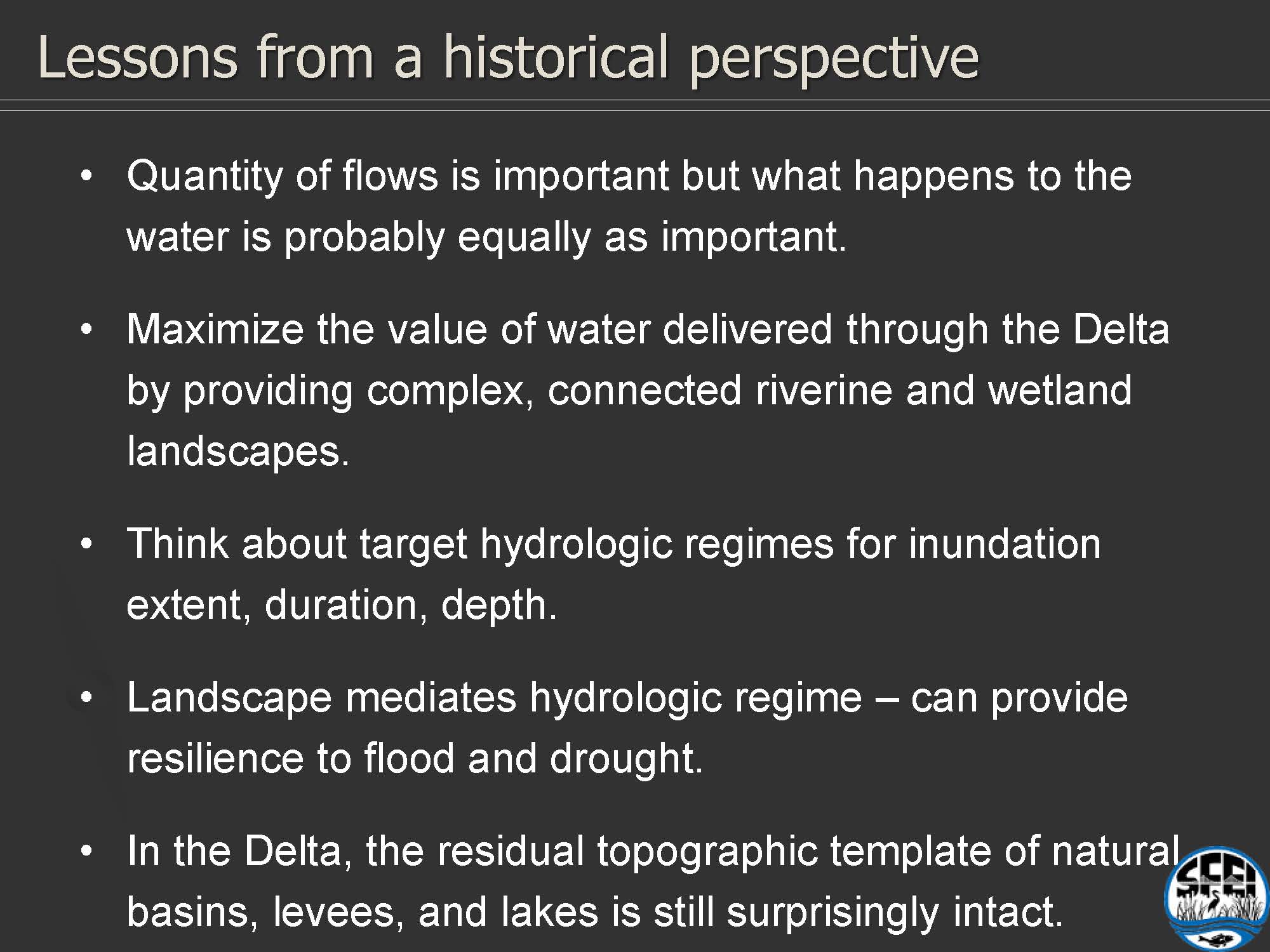 “So in conclusion, the quantity of flows is really important, but what happens to the water is probably equally important – how it’s used by the ecosystem downstream,” Mr. Grossinger said. “Not to diminish the importance of flows at all, but to more say that to maximize the value of that water, that valuable water, we want to give it complex connected riverine wetland landscapes to express itself across, and if we don’t do that, we may not be getting best advantage of the water.”
“We need to have clear goals that are realistic for the hydrograph, and they really need to be intertwined,” he said. “We could even work backwards to come up with … the complex flooding pattern that we want in the future and what does that require as a hydrograph from the upstream watershed. Because the landscape mediates the hydrologic regime, we think it can provide some resilience to flood and drought.”
 “A final point that I can’t help but add is that in the Delta, what we’re realizing as we compare historical to contemporary conditions is a fascinating amount of remnant topographic morphologic complexity is actually still there in the landscape. Once you get out of the Central Delta which is bizarrely subsided … we’re going to have trouble there. And we’re going to have trouble in the fairly small tidal areas, but surrounding areas, the floodplains, the flood basins, the natural levees, the natural depressions, gradual, complex topography – it’s kind of expensive to make, but it’s largely intact – surprisingly so, so one opportunity that presents itself is maximizing the benefit that the recipient Delta is getting from that adjacent component of the system.”
“So with that … “
FOR MORE INFORMATION …

