

Several news sources featured in the Daily Digest may limit the number of articles you can access without a subscription. However, gift articles and open-access links are provided when available. For more open access California water news articles, explore the main page at MavensNotebook.com.
On the calendar today …
- WEBINAR: NOAA Drought Seminar Series: Drought, El Niño, and California from 10am to 11am. When El Niño is mentioned with respect to California, images of extreme storms from the winters of 1983 and 1998 often come to mind. Although El Niño does shift the distribution of precipitation outcomes towards wet, dry outcomes do occur. Of the seven events where the Relative Niño Index exceeded 2.0 during winter in California, three ended up with below-average precipitation and below-average snowpack. In this virtual seminar, Michael Anderson, from State of California Department of Water Resources, will compare the seven very strong El Niño events, exploring factors that separate wet and dry outcomes in California’s water year. Click here for the agenda.
In California water news today …
Can hatchery reforms help California’s troubled salmon?
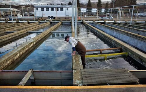
“Rivers in the Central Valley are so degraded by dams and water diversions that the tens of millions of Chinook salmon raised in hatcheries each year are essential to shoring up California’s salmon fisheries. But hatcheries can also have downsides. Artificially-produced fish can harm those born in the wild, both by introducing traits better suited to concrete raceways than rivers and by outcompeting them for food and the best spawning grounds and nurseries for young fish. “Hatchery fish are really contentious,” says Emily Chen, an ecologist at California Trout, a nonprofit dedicated to restoring the state’s freshwater ecosystems. “It’s a hot-button issue.” Another complication is that these days, even hatcheries can’t always safeguard the state’s salmon catches. … In the works are new practices that could lessen differences between hatchery and wild-born salmon and upgrades to make hatcheries more resilient to climate change. California has also increased production of young salmon bound for the ocean over the last few years, from about 20 to 33 million. But environmental conditions for fish are already bad and will likely get worse as the world warms. To flourish, salmon need restoration of the river systems where they begin and end their lives. … ” Read more at Maven’s Notebook.
Accelerating ecological restoration in the Sacramento-San Joaquin Delta and the Suisun Marsh
“Sustainable Conservation is proud to announce the new report: “Accelerating Restoration in the Sacramento-San Joaquin Delta and the Suisun Marsh: Progress and Next Steps.” Drawing on surveys and interviews with 27 organizations involved in Delta restoration, this white paper seeks to answer a crucial question: What more can be done to accelerate progress toward restoration and climate targets in the Delta and Suisun Marsh? California is a leader in aspirational climate goals, and in the Sacramento-San Joaquin Delta, some of those aspirations now are specific, legally established targets. The state’s Nature-Based Solutions Climate Targets, developed under Assembly Bill 1757, call for re-wetting 50,000 acres of subsided Delta peat soils by 2045 to meet the state’s carbon neutrality goal and reduce anthropogenic greenhouse gas emissions. In addition, The Delta Plan has a goal of restore 60,000–80,000 acres of habitat by 2050. … ” Read more from Sustainable Conservation.
Breathing life back into meadows: restoring resilience miniseries
“Naturalist John Muir wrote of the beauty of Yosemite’s mountain meadows, describing them as, “so brightly enameled with flowers and butterflies that it may well be called a garden-meadow.” Recent research suggests Sierra-Cascade meadows may once have covered nearly three times their current extent. Healthy meadows play an important role in storing floodwaters, improving water quality, and recharging groundwater. These areas also function as natural firebreaks because of their high soil moisture and sparse tree cover, providing critical refuges for wildlife during wildfires. Additional benefits include capturing sediment and reducing erosion. Equally important, meadows support an exceptional diversity of plants and wildlife, providing essential habitat for pollinators, amphibians, birds, mammals, and native fish. Meadows also act as important carbon sinks, storing greenhouse gases in their saturated soils for centuries. Today, meadows make up less than two percent of the Sierra-Cascade landscape, yet they store an estimated 12 to 31 percent of the region’s organic carbon. When these areas become degraded and dried, those same soils can release stored carbon back into the atmosphere and lose many other essential ecosystem functions. … ” Read more from FishBio.
El Niño has surged into record waters. 11 charts and maps that show its strength
“El Niño, as you might have heard already, is a big deal this year. The eastern Pacific is running as warm as it ever has going back into the record books. And with more warming expected over the next two to three months, there will be no shortage of attention given into early 2027. At that makes sense — El Niño can be a big event for the world. As it reshapes weather patterns globally, it influences the occurrence of drought, rain and even hurricanes (as we are seeing right now in the eastern Pacific). Here is an El Niño explainer if you are curious. In short, El Niño is an accumulation of warm water in the eastern Pacific Ocean that reoccurs every two to seven years. Very strong El Niño events has been associated with floods and famine in the past. That’s not to say anything of the sort is guaranteed soon — single events are never guaranteed this far out — but there are reasons to take this El Niño seriously thanks to just how astonishing some of the numbers are. … ” Read more from the Sacramento Bee.
Other strong El Niño years show what California’s 2026 winter might look like
“No two El Niño years are the same, but one of the best ways to try to figure out what’s going to happen this winter is to look back at previous winters that had similar setups going into the season. However, scientists only started recording El Niño years and their impacts in 1950, and although there have been 28 El Niño events since then (and 25 La Niñas), only three of those winters saw very strong El Niño events like this year: 1982-82, 1997-98, and 2015-2016. The past 28 events on average saw wetter-than-normal conditions across the entire state of California; Southern California saw 110-120% of normal rainfall, while northern CA averaged 100-110%. Weak El Niño events normally see below-average precipitation for the Bay Area, while Southern California still averages above normal. In fact, all of the central and southern coast of California averages wetter-than-normal for moderate, strong, and very strong events. … ” Read more from CBS Sacramento.
Concern mounts over slow-moving, planetary-scale ‘Kelvin’ wave heading for California
“Concerns are mounting about an ocean phenomenon known as a Kelvin wave that could raise sea levels along the California coastline by up to a foot, as scientists say El Niño is supercharging the threat of storm surges and flooding in the coming months. As an incredibly strong El Niño continues to develop in the Pacific, the phenomenon brings with it a strange shift in the ocean. The Kelvin wave phenomenon is created when trade winds that usually blow from South America towards Asia die down or reverse in El Niño years, setting off a massive, slow-moving slosh of water. Kelvin waves are not like crashing waves at the beach. They are planetary in scale, spanning thousands of miles. And when a Kelvin wave kicks off, it brings with it an untold amount of warm water that slowly moves from the western Pacific, along the equator, towards South, Central and North America. … ” Read more from The Guardian.
A parade of East Pacific hurricanes will miss CA (but soak the interior Southwest) before major, long-duration autumn heatwave builds
“It has already been a remarkable, and arguably historic, East Pacific hurricane season. Three hurricanes (Lala, Lowell, Nolo) have now directly impacted the Hawaiian Islands (though none made formal landfall), with significant flooding and associated water/wind damage occurring on both Kauai and the Big Island). 2026 thus marks the first time in recorded history in which 2 or more hurricanes have each passed within 50 miles of Hawaii, and joined only a handful of other years when 3 storms came within 100 miles. And recent activity in the east and central Pacific basin has upped the ante even further: Hurricane Polo exploded from a modest swirl of tropical thunderstorms into a top-end Category 5 storm in less than 24 hours (eventually achieving peak sustained winds of 180 mph), becoming either the fastest, or second fastest, intensifying hurricane ever observed in the Central or Eastern Pacific basins (the only other possible contender was Hurricane Patricia in 2015). And total Accumulated Cyclone Energy (ACE)–a measure of the total tropical storm and hurricane activity over a season–across the entire basin is now around 230% of average (a record for the calendar date). And this is exactly as had been predicted … ” Continue reading from Dr. Daniel Swain at Weather West.
How much water do data centers use? And why does it matter?
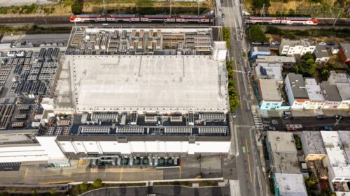 “Growth in Artificial Intelligence (AI) and other cloud-based computing services is driving an unprecedented expansion of data centers across the globe. As data centers have become much larger and more concentrated, concerns about impacts on water and energy systems have intensified. This issue brief summarizes what we know about data center water use and addresses common misunderstandings. While data centers represent a relatively small proportion of global or national water use, data center water use can be locally significant, especially in water-scarce and rural areas. The lack of standardized reporting on the number, size, location, and water use of data centers makes it difficult for communities, water managers, and decision-makers to understand and adequately address potential impacts. … ” Read more from the Pacific Institute.
In the American West, do two households really consume an acre foot of water a year?
“A commonly cited metric claims that two households typically use an acre foot of water a year. But thanks to conservation in western cities an acre foot is often enough for 3-1/2 to 6 households. So why are government agencies, academics, and news agencies continuing to use an obsolete metric that makes residential water users look like they’re wasting water? It’s bad enough that “40 million people” are reported to depend upon the Colorado River, while agriculture – which uses 80% of that water isn’t mentioned, while at the same time claiming that households are using twice as much water as they really are. The fact is that while the populations of cities have increased, per capita water use has fallen, dramatically. … ” Read more from Coyote Gulch.
Why one of California’s most prestigious wineries is fighting a state water conservation plan
“Following nearly a decade of investment in the agrarian Suisun Valley, Caymus Vineyards is fighting a state water conservation policy that it sees as a threat to the burgeoning wine region. Solano County’s 23-square-mile Suisun Valley has been recognized as an American Viticultural Area since 1982, but it was largely unknown as a wine destination before Caymus, one of Napa Valley’s best-known wine brands, came to town. Since founder Chuck Wagner moved the bulk of Caymus’ wine production to Solano County in 2018, his family has taken over hundreds of acres of local vineyards and built an enormous tasting room in the valley’s windswept hills. … ” Read more from the San Francisco Chronicle. | Read via Yahoo News.
California farmers are struggling to sell grapes as demand for wine drops
“It’s harvest time in California wine country, but many growers are struggling to sell their grapes as changing drinking habits have caused demand to plunge. The decline is forcing some growers to tear out vineyards that their families have grown for generations. Wine sales have decreased by more than 20% over a five-year period, causing prices paid for grapes to drop and prompting California growers to take roughly a quarter of the state’s vineyards out of production. Many growers are having to decide whether to harvest at a loss, leave grapes on the vine or replace vineyards with crops more in demand such as almonds, walnuts, pistachios and olives. Third-generation grower Bill Berryhill said it means another year of losing money and wasting hundreds of tons of healthy grapes. … ” Read more from the Associated Press.
Jason Giannelli: California water, farming and the next generation
“California agriculture is facing a complicated mix of water shortages, rising fuel costs, regulatory pressure, labor challenges and rapid technological change. For fourth-generation Kern County farmer Jason Giannelli, those challenges are not theoretical—they are part of the daily reality of keeping a family farming operation productive. Giannelli, director of farming for Old River Farming and R&G Fanucci and president of the California Water Alliance, joined “The Ag Meter” Nick Papagni for a wide-ranging conversation about water, agriculture, energy, technology and the future of farming in California. Giannelli also serves on the boards of the Water Blueprint, Central Valley Business Federation and Kern County Water Association. As the farming season winds down, Giannelli said the water situation remained particularly difficult. His operation had to make tough decisions, including leaving some ground empty, but ultimately made it through another challenging year. … ” Read more from AgNet West.
Draft report: Farmland Conversion in the Delta: Protecting Agriculture as Part of the Coequal Goals
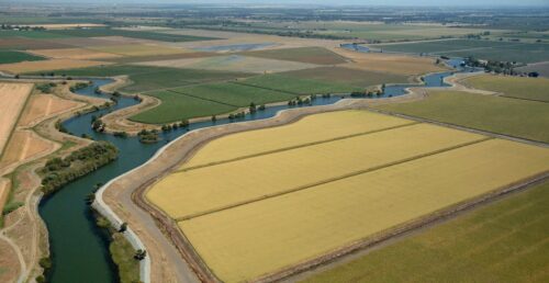
“Public comment opens today on the Delta Protection Commission’s draft report, “Farmland Conversion in the Delta: Protecting Agriculture as Part of the Coequal Goals.” The draft report highlights a public policy gap inherent in implementation of the “coequal goals” established by the 2009 Delta Reform Act. The coequal goals call for a more reliable water supply for California and protection, restoration, and enhancement of the Delta ecosystem, while requiring that the goals be achieved in a manner that protects and enhances the Delta’s agricultural values. Implementation of those goals is guided by the Delta Plan, which was adopted in 2013. … ” Read more from the Delta Protection Commission.
Public input opportunity: Effects on fish from long-term operations of Central Valley Project and State Water Project independent scientific peer review
“At the request of the U.S. Bureau of Reclamation, the Delta Science Program is facilitating an independent scientific peer review of new lines of evidence for effects on fish from the long-term operations of the Central Valley Project and State Water Project, and the resulting impacts on their populations. Interested parties are invited to submit no more than two pages of input relevant to the charge questions by October 16, 2026, via email to reviewadvice@deltacouncil.ca.
In commentary today …
California’s coast still needs protecting
Columnist Pete Golis writes, “To understand the Trump administration’s efforts to weaken the authority of the California Coastal Commission, it’s important to recall what might have happened on the Sonoma County coast. Imagine: A sprawl of second-home subdivisions and strip malls, beaches closed to all but the wealthiest among us, oil platforms and onshore oil facilities, an aging nuclear power plant at Bodega Bay. Without Californians’ commitment to protecting the coast, all this and more could have happened. Now the Trump administration is accusing the state Coastal Commission of being in violation of federal law for resisting offshore oil wells, undersea pipelines and other industrial ventures in the coastal zone. Trump and his acolytes want to be able to decide federal and federally-authorized projects without interference from California. … ” Read more from the Santa Rosa Press Democrat.
In regional water news and commentary today …
NORTH COAST
One solution at a time can transform Klamath Basin’s water future
Dan Keppen, President of Keppen & Associates, writes, “My wife and I are moving away from the Klamath Basin after living and working there for 25 years. Naturally, I’ve been reflecting on what has happened here since we arrived, as well as on what might happen next. We arrived in Klamath Falls, Ore., in 2001, the year water was shut off to Klamath Project irrigators for the first time in the project’s 98-year history. I began a four-year stint as executive director of the Klamath Water Users Association, representing those struggling irrigators. Both professionally and personally, it was one of the most challenging times of our lives. Twenty-five years later, the Klamath River watershed is still viewed by many as the poster child for Western water conflict. We have earned some of that reputation. There have been lawsuits, protests, droughts, regulatory battles and ambitious attempts at wide-ranging agreements. Some efforts produced lasting benefits, while others fell short of their promise. But good things happened this summer that deserve attention and give me hope. … ” Read more from Farm Progress.
SIERRA NEVADA
New study finds microplastics 3-4 times higher in Truckee River than Lake Tahoe
“Microplastics are occurring at a higher concentration in the Truckee River than in Lake Tahoe by a factor of 3-4, according to a recently published study. Researchers say this could mean the extra pollution is coming from the river’s surrounding landscape and emphasize that reducing single-use plastics is critical to protecting the river’s water quality. It’s another study within the last few years seeking to understand this ubiquitous material and how it impacts human and environmental health. Folks in the Tahoe region might recall a study a few years ago that found Lake Tahoe had the third-highest concentration of plastic among 38 lakes tested worldwide, adding perspective to this recent study. Adding further context, the Truckee River’s concentrations are comparable to those found in studies of other Western rivers. … ” Read more from the Tahoe Daily Tribune.
SACRAMENTO VALLEY
New water plant will bring trail upgrades to Redding
“People who enjoy getting out on the Sacramento River Trail will benefit from the proposed construction of a new $74 million water pumping plant to replace Pump Station 1 in Redding. An upgrade for the station known as “the workhorse of Redding’s municipal water system” is long overdue, given the pump house’s age, deferred maintenance and workload, city officials have said. … ” Read more from the Redding Record-Searchlight.
BAY AREA
$5 million EPA grant will fund San Francisco stormwater system improvements
“A $5 million federal grant will help fund badly needed upgrades to San Francisco’s stormwater drainage system. The money from the U.S. Environmental Protection Agency was announced Friday by the San Francisco Public Utilities Commission. The upgrades will center around five acres of paved surfaces in the Outer Mission neighborhood, a residential neighborhood on the city’s southern border, east of Lake Merced and San Francisco Golf Club. The project will involve installing rain gardens, planted greenery, and underground filtration systems in five locations, according to a statement from the Public Utilities Commission. … ” Read more from Local News Matters.
16 sunken vessels set for removal from Oakland Estuary
“The Oakland Police Department’s Marine Unit will remove 16 sunken vessels from the Oakland Estuary over the next two weeks as part of an ongoing effort to clear abandoned and derelict boats from the city’s waterways. The operation follows the removal of more than 50 abandoned, derelict or surrendered vessels in recent months, according to the police. Police said dozens of vessels had been illegally anchored in the Jack London Aquatic Center basin, creating environmental hazards and limiting access to the water. The Marine Unit worked with the City and City Attorney’s Office to identify vessels, notify owners, and arrange voluntary surrenders, police said. OPD officers also traveled to Sacramento and San Jose to locate owners and secure vessels for removal. … ” Read more from Local News Matters.
SEE ALSO: Police say abandoned boats fueled crime on Oakland’s waterfront. Now comes the cleanup, from the San Francisco Chronicle
CENTRAL COAST
UC Berkeley researchers create digital twin of Pajaro Valley to test future flood risks
“The farming communities along the Lower Pajaro River that divides Monterey and Santa Cruz counties have suffered five multi-million dollar floods since a system of levees was built in 1949. Now, researchers are building a dynamic virtual version of the region to simulate flooding scenarios over time, while taking account of a variety of factors such as climate risk. Led by UC Berkeley researchers Anna Serra-Llobet and Adda Athanasopoulos-Zekkos — working with members of Austria’s Vienna Research Center for Visual Computing — the project is developing a digital twin, or a dynamic virtual simulation, of the Lower Pajaro River Valley, known locally as “the strawberry capital of the world.” The model will allow researchers and planners to simulate flooding in 3-D over time and test different management strategies such as setback levees, built farther back from a river to widen the natural flood plain. … ” Read more from Local News Matters.
Carmel is racing to trim or remove 1,000 trees ahead of El Niño
“There is arguably no city in California, or maybe even the nation, more protective of its trees than Carmel. But in the run-up to what portends to be a historic El Niño winter, a massive effort is underway in Carmel to identify trees that are unhealthy, dying or dead. They could pose a threat to the town’s citizenry and infrastructure as a super El Niño winter season grows near. Tree life in Carmel is highly valued and even has a special commission that provides oversight to the town’s 10,000-tree canopy. Mayor Dale Byrne told SFGATE earlier this month that he estimates more than 1,000 trees “need to be cut down or trimmed extensively” in the run-up to the winter months. PG&E is spearheading the effort and will complete the lion’s share of the work, according to the mayor. … ” Read more from SF Gate.
Deal would shift State Water rights from Montecito to proposed Solomon Hills development in Santa Barbara’s North County
“A deal on the table Tuesday would promise more than 40% of Montecito’s State Water Project rights to a massive North County development proposal. The $40 million sale would put Solomon Hills—4,000 homes planned between Orcutt and Los Alamos—a big step closer to securing a critical ingredient needed for that project to move forward. The Montecito Water District Board at its monthly meeting Tuesday will consider a non-binding letter of intent to forever relinquish 1,400 acre feet, or 42.4%, of the agency’s annual State Water Project interests. That’s enough water to sustain an estimated 10,000 to 15,000 California residents a year. “We are able to divest,” Floyd Wicks, board member and past president, said. “We have been building this plan for years… Our board and staff planned very strategically.” … ” Read more from the Santa Barbara News Press.
SEE ALSO: Montecito Mulling State Water Allotment Sale to Solomon Hills Development, from Noozhawk
SOUTHERN CALIFORNIA
Hurricane Polo expected to bring strong swells to Southern California, prompting coastal flood advisory
“As Hurricane Polo continues moving with intensity in the Pacific Ocean, weather officials have issued a coastal flood advisory for Southern California beach communities. The National Weather Service says the Southern California coastline is expected to see remnants of Hurricane Polo through Tuesday. South-facing beaches could experience strong surf, moderate coastal flooding and dangerous swimming conditions. An NWS coastal flood and high surf advisory will be in effect until 5 p.m. Tuesday for Ventura County beaches, Los Angeles County beaches and the Malibu coast. Although weather officials say that the surf will likely be smaller than Hurricane Marie, which impacted the coastline earlier this month, the lingering erosion effects could enhance flooding. … ” Read more from CBS Los Angeles.
A century of sand debt comes due in Malibu
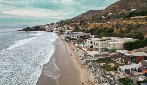 “On a clean summer swell, the wave at Malibu’s Surfrider Beach arrives from the south, wraps around a cobblestone point and unspools toward the pier in a long, shimmering wave that can carry a surfer for hundreds of feet. It breaks slowly, forgivingly, over rounded stones that were delivered by Malibu Creek across millennia. … Kassia Meador has been reading this wave for nearly 30 years. She was 15 the summer she first paddled out at Surfrider Beach, and she has spent the decades since becoming one of the most recognizable longboarders in the world. She calls it, without hesitation, the best wave on the planet. Lately, when Meador paddles out, something is missing beneath her: the beach. The sand at Surfrider Beach has thinned to the point where, at high tide, the ocean reaches almost to the Pacific Coast Highway. … What’s happening at Malibu is about human intervention—a century of dams, seawalls and paved-over rivers that have starved this coastline of the sediment that builds its beaches. But it is becoming a climate story, fast, because a coast stripped of its natural defenses is a coast with nothing left to absorb what’s coming. And what’s coming this winter is a lot. … ” Read more from Inside Climate News.
Wrightwood residents fight a quarry they never saw coming
“When residents of Wrightwood, a pine-studded village near Mt. Baldy, learned that a massive quarry was planned nearby, they followed a familiar playbook. They organized a nonprofit, drafted a petition and raised funds for a legal challenge. They created T-shirts, ball caps and tote bags. They won support from powerful politicians. But they may be seven years too late. By the time they learned about the quarry planned on 420 acres in lush Lone Pine Canyon, where ultra-high purity calcium carbonate would be extracted by blasting down about 1,600 feet across open pits, the project had long ago received a key approval. In 2019, after two meetings that flew so under the radar that only one member of the public spoke out, the San Bernardino County Planning Commission voted 3 to 2 to grant “vested rights” to the quarry, exempting the project from a comprehensive environmental review. … ” Read more from the LA Times. | Read via Yahoo News.
SAN DIEGO
Sea level rise is reshaping a California beach town and threatening a key rail line
“For years, residents of this Southern California beach town could walk a mile along a stretch of cream-colored sand and dip their toes in the waves lapping ashore. That trip has been cut short. Coastal erosion has been eating away at the beach in San Clemente, known for nearly a century as a “Spanish village by the sea.” The rising sea and crashing waves have pushed the shoreline landward, splitting the city’s picturesque North Beach. Crumbling seaside bluffs have damaged oceanfront homes and forced the repeated closure of a passenger rail line considered the second busiest in the country. It’s one of many California coastal communities grappling with the effects of sea level rise. Nearly a decade ago, scientists forecast that more than half of Southern California’s beaches could significantly erode by 2100, radically altering how people live and recreate along the state’s famed coast. … ” Read more from the Associated Press.
Imperial Beach coastline closed over sewage contamination
“The Imperial Beach shoreline was closed to human contact Sunday by county health officials due to sewage contamination. The San Diego County Department of Environmental Health and Quality said the Tijuana River was flowing and reaching recreational waters. “Beach goers are advised that the ocean water contains sewage and may cause illness,” the DEHQ said in a statement Sunday. “Ocean waters will remain closed until sampling and field observations confirm these areas are safe for water contact.” … ” Read more from the Times of San Diego.
SEE ALSO: Imperial Beach shoreline closed due to sewage contamination, from NBC 7
Along the Colorado River …
Drying Colorado River seen as risky bet for Mexico water swap
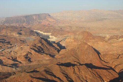 “A proposal to find new water for the Southwest by using desalinated ocean water from Mexico faces difficult odds as what remains of the waning Colorado River is legally contested by its surrounding states. Southwestern states for years have sought to find new sources of water in a drying region, and desalination, the process of removing salt from ocean water to make it potable, is one of the solutions they’re studying. Arizona advanced one such project on Sept. 16, which proposes to provide water for Mexico in exchange for part of the state’s share of Colorado River water. The proposed Northern Gulf of California Desalination Project calls for Arizona to build a plant in the Gulf of California to supply drinking water to residents in Baja California, Mexico. Arizona would then use some of Mexico’s supply of Colorado River water to augment its own. But the project faces the same challenge threatening water throughout the region — too little Colorado River water to go around. … ” Read more from Bloomberg.
Snow is critical for Arizona’s water, this study found that measurements can vary wildly
“When water managers in Arizona are trying to plan for how much water they’ll get from rivers and reservoirs, they look to the mountain snow. A new study compares different programs for measuring that snow, and found that they produce wildly different estimates. The study, published in the journal Water Resources Research, mostly found problems with long-term models, and said most water managers in the Southwest are using more accurate systems for predicting the amount of water in reservoirs in the near term. High-altitude snow is far more important to the Southwest’s water supply than summer rains, so getting accurate data about that snow is pivotal for the people who make plans for the water that flows to cities and farms across the region. At a time when the Colorado River is stretched thin, measuring water supplies down to the drop can make a big difference for the tens of millions of people who depend on it. … ” Read more from KJZZ.
What Colorado River cuts mean for Arizona water customers
Doug Dunham, Water Resources Director at EPCOR, writes, “With federal cuts reducing Arizona’s Colorado River allocation by 27% each year through 2028, many people are coming to us concerned and asking: “Will I still have water?” “Will my tap run dry?” “What should we do?” The short answer is that Arizona faces serious long-term water challenges, but these cuts do not mean customers should expect their taps to suddenly run dry. Utility providers have been banking water, diversifying supply portfolios, modeling shortage scenarios and developing ways to shift water sources as conditions change. At EPCOR, we have been proactively planning for shortages for more than a decade by working to reduce our use of Colorado River supplies while using stored water and other resources to protect customer reliability. … ” Read more from the Arizona Daily Star.
Colorado says goodbye to a “doozy” of a water year with more moisture in the forecast
“Water year 2026 is coming to an end, and good riddance. Colorado water officials base their calendars on the water cycle each year, starting new years on Oct. 1. This time, the restart is much needed. Coloradans have endured record temperatures, closures, water cutoffs and the winter-that-wasn’t, when barely any snow fell compared with past years. “It was a doozy,” Peter Goble, assistant state climatologist, said. What’s one main takeaway from the year? The state was 5.6 degrees Fahrenheit warmer from October 2025 through the end of August than the 1971 to 2000 average. That makes it the warmest water year on record by a big margin, so it’s no surprise that December, February, March and August all broke heat records. … ” Read more from the Colorado Sun.

