
Scripps Oceanography scientists share how El Nino mean for the California coastline
By Lauren Fimbres Wood, Scripps Institution of Oceanography
 El Niño is defined by the persistence of warm water in the Pacific Ocean at the equator. This warm water has impacts on global temperature, weather systems and marine life.
This El Nino-driven warming also makes sea levels higher because water expands as it heats up due to thermal expansion, and can mean bigger waves along the U.S. West Coast.
Below scientists with Scripps Institution of Oceanography at the University of California San Diego explain how the California coastline could be impacted by the approaching El Niño, and why data programs that help scientists track and forecast coastal impacts are vital to understanding this El Niño.
For additional information on El Niño, visit the El Niño Resource Hub.
What can Californians expect from a typical El Niño year?
Mark Merrifield (Physical Oceanographer and Director of the Center for Climate Change Impacts and Adaptation): The California coast experiences anomalously high sea levels and a deeper upper ocean warm layer during an El Niño event. The deep warm layer inhibits upwelling of nutrient-rich waters, with associated impacts to marine ecosystems. Winter storm tracks in the Pacific shift, resulting in higher surf along the California coast. Changing storm patterns also may lead to above-normal rainfall.

How does El Niño impact the California coast?
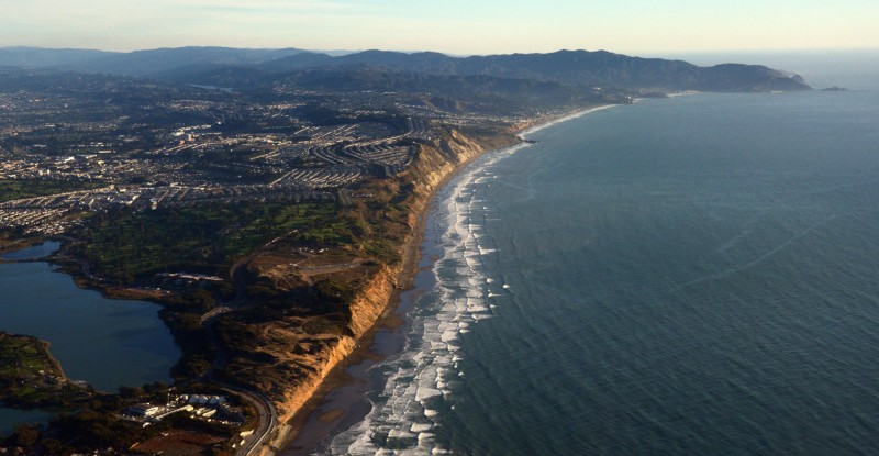
Adam Young (Coastal Geomorphologist): El Niño conditions can generate a triple threat for coastal hazards in California. Increased rainfall triggers landslides; powerful waves can accelerate erosion of beaches, sea cliffs, and bluffs, and cause coastal flooding; and strong El Niño conditions can raise sea level on the California coast by 15 to 30 centimeters (6-13 inches). Combined, these factors increase coastal erosion and flooding during El Niño events, which can threaten public parks, beaches, critical infrastructure, highways, and homes.

Some of what determines the severity of impacts is related to the timing of winter storms. For example, if large waves arrive during a very high tide, the potential for coastal flooding and other types of damage increases significantly. Multiple sequential storms can also be a factor. The first storm may strip all the sand off a beach, and without the natural sand buffer, the next storm can deliver a stronger punch. Every El Niño is different but these conditions increase the possibility for significant coastal impacts.
It’s important for us to monitor this year’s El Niño by mapping the coastline before and after the event so we can measure how the coast responds. The elevated sea levels associated with El Niño also provide a snapshot of how future sea level rise might impact our coast. Collecting these data is essential to improve our ability to predict hazards and plan for the future.
Why can the coast see bigger waves during an El Niño? When might the coast start to see these wave impacts?
Mark Merrifield (Physical Oceanographer and Director of the Center for Climate Change Impacts and Adaptation): An eastward shift in convective activity in the tropics perturbs mid-latitude storm tracks in the North Pacific, leading to higher waves along the California coast. Coastal wave buoys maintained by the Coastal Data Information Program document high surf beginning to appear in late autumn and early winter during an El Niño event.
Additionally, in an unlucky coincidence, the tidal cycle is also going to be at a peak around the end of 2026. Tides tend to vary over long time periods in what’s known as the 18.6 year lunar node and 4.4 year lunar perigree tidal cycles. We are near the peaks of those cycles this year. That means that around Christmas time, California will see some very strong king tides that will superpose on the high sea levels caused by El Niño.
Historically, what have been the biggest waves that have been measured along the coast during past El Niño events?
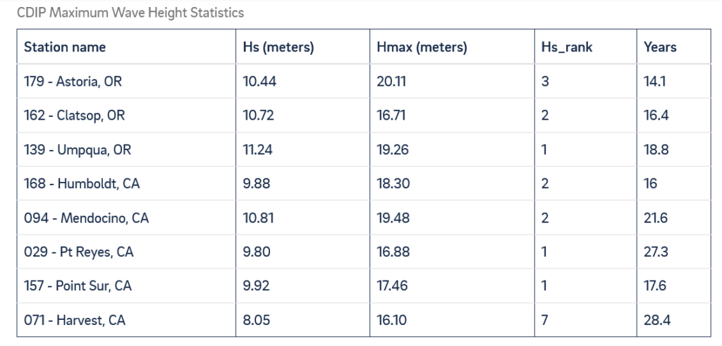
Randy Bucciarelli (Programmer/Analyst with the Coastal Data Information Program): The largest waves measured by CDIP occurred during the strong 2015–2016 El Niño. Significant wave heights exceeded 30 feet along the coast from California to the Washington border, reaching a maximum of 37 feet at Umpqua, Oregon. Individual waves exceeded 50 feet across the same region, with a maximum of 66 feet recorded at Astoria, Oregon. This event remains the largest on record at several of CDIP’s long-term stations, including Point Reyes, which has more than 27 years of observations. In California, the largest waves measured by CDIP wave buoys during an El Niño year were in Mendocino and Point Reyes, where individual waves exceeded 63 feet and 55 feet during a December 2015 storm.
How can scientists track these coastal impacts during an El Niño?
Adam Young (Coastal Geomorphologist): One way scientists can track coastal impact is by conducting high resolution topographic lidar surveys. Surveys conducted before and after the El Niño can be compared to measure beach erosion, cliff retreat, and infrastructure damage. These surveys provide critical information for coastal management and planning. The Scripps California Mapping Program began statewide surveys in 2023 and will survey the entire California coastline in the fall of 2026 and spring of 2027 to quantify the changes from the upcoming El Nino.

The California coast has already been experiencing a marine heat wave. What could an El Niño mean on top of already high ocean temperatures?
Art Miller (Research Oceanographer and Senior Lecturer in Climate Sciences): As El Niño develops further over the coming seasons, the ample heat already sequestered beneath the surface of the tropical Pacific is poised to drive a stronger El Niño transition there. We expect that it would add to the strong, persistent regional ocean warming (marine heat wave) that has been prevalent off the U.S. West Coast and Baja since early 2026. Wind-driven coastal upwelling, which normally occurs in spring and summer, has been rather weak so far in Southern California. As a result, it appears likely that ocean warming along our coast will increase this summer and continue into the fall and winter because El Niño warms our coastal ocean in two distinct ways. First, El Niño conditions change the atmospheric winds over the North Pacific in fall/winter along our coast, which pushes warmer waters from offshore towards the normally cooler coastal regions. Second, El Nino conditions instigate subsurface waves in the ocean that are trapped along the coast and that push down the surface waters to suppress cool-water upwelling along the coast thereby causing ocean warming.

The presence of El Niño-fueled marine heat waves off our coast can slightly affect the air that arrives in coastal California by slightly warming it and slightly increasing the humidity, making summer and fall less comfortable, and it may somewhat enhance rainfall during the fall/winter seasons. Additionally, marine ecology can be disrupted by marine heat waves due to numerous factors. Decreased vertical mixing can suppress nutrients from reaching the sunlit upper ocean, which fuels the base of the food chain and can thereby lead to less food availability for birds, sea lions, whales and other marine life. Shifts in fish species can occur as tropical species move into our normally cooler ocean waters (Learn more in this Q&A on marine ecosystem impacts). The double-whammy of an existing strong marine heat wave enhanced by a Super El Niño could wreak havoc on our coastal ecosystem and the economies that rely on it.
Daniel Rudnick (Professor of Physical Oceanography): The temperatures we are observing on two of our underwater glider lines, at Pt. Conception and Monterey Bay, are the highest we have seen them in 20 years as a result of the ongoing marine heat wave. This marine heat wave is unusual in that it developed over the past year while temperatures at the equator were cool. With the onset of the El Niño the question is whether the existing marine heat wave will continue to grow. Measurements in the next several months will be telling.

