
Several news sources featured in the Daily Digest may limit the number of articles you can access without a subscription. However, gift articles and open-access links are provided when available. For more open access California water news articles, explore the main page at MavensNotebook.com.
In California water news today …
El Niño continues to strengthen. What does that mean for flood risk this winter?
“The already strong El Niño conditions in the Pacific Ocean continue to grow stronger, federal scientists said Thursday, with a 69% chance that this year’s event will be the strongest since modern records began in 1950. Scientists at the National Oceanic and Atmospheric Administration in College Park, Maryland announced there is a 90% chance of a very strong El Niño through this fall and winter as water temperatures along the equator off South America continue to rise. But while El Niño increases the odds of wet winters in California, it doesn’t mean what many people assume: That flooding is imminent later in the year for residents who live along rivers and creeks. Of the 10 worst flooding years in California since 1950, ranked by dollar damage compiled by the California Office of Emergency Services, only three came during El Niño years. … ” Read more from the San Jose Mercury News.
A ‘super’ El Niño is now super likely, leaving California bracing for impact
“A “super” El Niño now has a 95% chance of developing this year as the climate pattern gains dramatic strength in the Pacific Ocean — leaving officials across California and beyond bracing for a wet and potentially destructive winter. The National Oceanic and Atmospheric Administration’s Climate Prediction Center said Thursday that the El Niño has strengthened in the last month, and there’s a roughly 7 in 10 chance it will be the strongest such pattern since 1950. Of the three other powerful El Niños on record during that span — in 1982-83, 1997-98 and 2015-16 — two brought above-average rain to Southern California. The 2015-16 El Niño, while very strong in the ocean, did not, though the pattern was blamed for record beach erosion along the California coast. … ” Read more from the LA Times. | Read via Yahoo News.
Why is El Niño so hard to understand?
Eric Epstein writes, ““El Niño” has been in Californians’ common lexicon for the better part of three decades, ever since a particularly destructive winter in 1997-98 thrust the weather phenomenon into the spotlight. This summer, the confidence of forecasts projecting a “strong” or “very strong” El Niño skyrocketed to 97%. As a born-and-raised Northern Californian, I have long interpreted the emergence of El Niño as the West Coast’s version of Punxsutawney Phil seeing his shadow: it means we’re in for a long, very wet winter. I have since learned it’s not so simple. I’d like to think this reductive interpretation of El Niño is frequent among us Californians, even as terms like “atmospheric river,” “bomb cycle,” and “heat dome” have forced 21st-century meteorological literacy upon us. … ” Read more from Sustainable Conservation.
SEE ALSO:
-
- Early-onset El Niño, from the New York Times
- El Niño is strengthening fast. NOAA says a record event is now likely, from the San Francisco Chronicle
California law aimed at saving groundwater risks crushing state’s small farmers, according to report
“Small farmers in the San Joaquin Valley are struggling with groundwater regulations to the point that 85% of 170 farmers surveyed for a recently released report said they were concerned they would have to shut down. Others said they are “cutting their farms in half, or more,” said Alyssa DeVincentis, one of the report’s authors, with the California Alliance with Family Farmers, during a webinar held August 3 to discuss the “Managing Groundwater With Small Farms in Mind” report. “They’re actually reducing the amount of food that they’re producing,” DeVincentis said. That’s a very real and substantial impact of how the Sustainable Groundwater Management Act (SGMA) is affecting small farmers, she added. … ” Read more from SJV Water.
SEE ALSO: SGMA Must Knows, from Water Wrights
Where did the birds go? Once-abundant wetlands are drying up after federal staff cutbacks
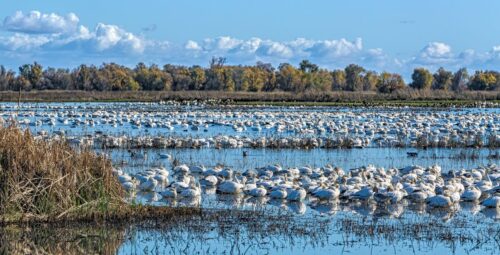
“Even on chilly January days in years past, it was possible to see and hear more than 100 kinds of birds at the Vierra Wetlands in the San Joaquin River National Wildlife Refuge. But last winter, dozens of species like the snowy egret, northern shoveler and the strikingly colorful wood duck did not appear. The seasonal wetlands, which are part of a larger pit stop for migratory birds on the Pacific Flyway, were nearly bone dry — and not because of a drought. The U.S. Fish and Wildlife Service simply didn’t have enough employees dedicated to opening the levees that flood the wetlands. It’s a reality playing across many of the national wildlife refuges in the country, including the 35 in California. Labor shortages at the federal government’s various land management agencies — which have intensified in President Donald Trump’s second term — have left departments with less capacity to manage the refuges. … ” Read more from Cal Matters.
California kills the Right to Clean Water Act, leaving state’s waters exposed to federal rollbacks
“Today, the Assembly Appropriations Committee failed to move SB 601, the Right to Clean Water Act, to the Assembly floor for a final vote. The bill, authored by Senator Ben Allen (D-Santa Monica), now has no possibility of being adopted this legislative session. SB 601’s death leaves millions of Californians and thousands of miles of streams and wetlands without the safeguards they enjoyed for the last half-century under the federal Clean Water Act. The U.S. Supreme Court’s 2023 decision in Sackett v. EPA stripped federal Clean Water Act protections from the majority of California’s wetlands and seasonal streams — the very waters that recharge our aquifers, filter our drinking water, and buffer our communities from flooding. SB 601 would have ensured that the same polluting discharges regulated under the Clean Water Act before the Sackett decision remain subject to equivalent protections under state law. “Today, our state leaders failed to meet the moment. At a time when states across the country are stepping up to protect their waters from the impacts of the Trump Administration’s rollbacks, California chose to stand down. Hopefully California’s next Governor will stand up for clean water protections over corporate interests — but today, the legislature and Governor Newsom chose instead to leave Californians vulnerable to increased water pollution,” said Sean Bothwell, Executive Director of the California Coastkeeper Alliance, a co-sponsor of the bill. … ” Continue reading from the California Coastkeeper.
The water temperature of the Bay-Delta is currently unsuitable for Delta smelt in summer
Tom Cannon writes, “The last significant brood year reproduction of Delta Smelt occurred in 2011 (Figure 1a and 1b). The last significant brood years occurred from 2010-2012, and the population then collapsed during the 2013-2015 drought. The Delta is too warm in summer to allow a Delta Smelt recovery. The demise of the Delta Smelt started in the late 1990s and accelerated from 2005-2006, above-normal and wet years that had unusually warm western Delta water temperatures in the prime Delta Smelt low-salinity-zone rearing habitat. The 2005-2026 decline of Delta Smelt and other pelagic Delta species was termed the Pelagic Organism Decline (POD).1 The POD was studied for two decades, with multiple factors considered, including warming of the Delta as it relates to increasing Delta water exports and the associated lower Delta outflow. … ” Read more from the California Fisheries blog.
Joe Del Bosque: California farming faces a critical future
“California agriculture is facing a growing list of challenges, but Westside farmer Joe Del Bosque says the industry’s future depends on practical solutions, innovation, water and ensuring the next generation has a reason to stay involved in farming. In the latest episode of the AgNet News Hour, “the Ag Meter” Nick Papagni and Sir Josh McGill welcome Joe Del Bosque of Del Bosque Farms for an in-depth conversation about the realities of farming on California’s West Side. Del Bosque, who farms in the Firebaugh-Los Banos area, discusses his specialty-crop operation and the challenges facing growers of cantaloupes, honeydews, watermelons and tomatoes. He explains that California farmers face high labor costs, extensive regulations and ongoing water challenges while competing against lower-cost imports. … ” Read more from AgNet West.
Stanford study links climate change, severe droughts to higher water bills in some communities
“Between climate change and severe droughts across the West, securing California’s water future is critical. But at what cost In a newly released study, researchers from Stanford’s Doerr School of Sustainability are putting a price tag on what a hotter and drier climate could mean for consumers. And in some areas they say it could result in water bills nearly doubling by the middle of this century. “Our goal was really to think about bringing the impacts of climate change all the way down to the household,” says assistant professor Sarah Fletcher, Ph.D. To gauge the impacts, Fletcher and colleague Jennifer Skerker, PhD, analyzed data from the city of Santa Cruz, which relies mainly on surface water, with just a single reservoir to store it. The city is already running an aggressive water conservation program, including groundwater injection wells. But the Stanford team wanted to understand how much water bills could rise if cities like Santa Cruz are forced to build new and even more expensive systems. … ” Read more from ABC 7.
Can ‘digital twins’ help California manage its growing flood risk?
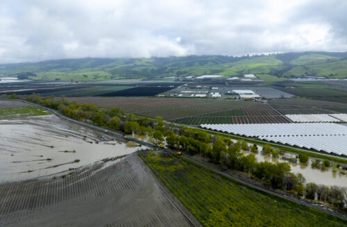
“Approximately 1.4 million Californians live in areas that are at high risk of flooding each year, and climate change is only driving this number up. But flood risk can be a tricky concept for residents and policymakers alike to grasp. Just looking at a FEMA map or knowing that a home is built in a 100-year floodplain doesn’t give people an intuitive understanding of how likely it is that a flood will occur — or what could happen when one does. But what if it was possible for people to actually see what it would look like when their community floods, and how specific management decisions, like levee improvements, might change the picture? That’s the goal of an ongoing UC Berkeley-led project exploring how hydrodynamic digital twins can help California residents and policymakers better understand and manage flood risk. “Digital twins are opening a whole new world on how we can think about risk,” said Anna Serra-Llobet, a senior scientist at the Berkeley Center for Smart Infrastructure. … ” Read more from UC Berkeley.
Federal job cuts are making wildfires harder to fight
“At the start of what is becoming an intense wildfire season this year, federal officials warned of a 15 percent decrease in available “hotshot” teams, the elite squads that fight complex blazes in the most rugged areas. In Washington State, officials had to call in the National Guard and 250 active-duty U.S. Army soldiers to help extinguish embers because they didn’t have enough firefighters. And as fire raged in central Utah this month, one team called for help but waited for days. By the time more hands arrived last week, two firefighters working under contract with the U.S. Forest Service had been killed in a helicopter crash and the flames had spread significantly. “Nobody has all they need,” said Joe Stutler, a veteran fire incident commander who recently retired as the Deschutes County forester in Oregon and spent 35 years in the Forest Service. “This is an extraordinary year.” … ” Read more from the New York Times.
In commentary today …
How the Trump administration could limit California’s power over its own coastline
Stephanie Altman, a senior energy and biodiversity specialist at Defenders of Wildlife, writes, “California’s coastline is one of the nation’s greatest conservation success stories. From recovering sea otters and nesting snowy plovers to migrating gray whales and the vibrant national marine sanctuaries that many species call home, generations of Californians have fought to protect the wildlife and places that make this coastline extraordinary. Few may realize these conservation successes are made possible, in part, by a little-known but critically important federal law: the Coastal Zone Management Act. For more than 50 years, the act has given California and other coastal states a meaningful voice in federal decisions affecting their shorelines. Through the law’s federal consistency program, California works with federal agencies and project proponents to ensure that offshore drilling proposals, pipelines, ports and other federally authorized activities are consistent with the state’s coastal policies. … ” Read more from the San Francisco Chronicle.
The looming emergency that should make us build more water infrastructure
Joe Pollak, opinion editor at the California Post, writes, “California faces potential water shortages if the states that use the Colorado River can’t make a deal. Seven states depend on the river, which winds from the Rocky Mountains through the Grand Canyon to the Gulf of California. The states take so much water from the river that it rarely reaches the sea. The Colorado River provides about one-third of Southern California’s total water supply. The past 25 years have been particularly dry. And two major dams on the river — Lake Powell and Lake Mead — are dropping to dangerously low levels. That means the states need to come up with a new water-sharing agreement. The federal government says it will impose cuts if there’s no deal. … But if conditions don’t improve, bigger water cuts are coming for California. And that could affect everyone, especially if there’s another drought. California is not short of water. But it is short of good water management. … ” Read more from the California Post.
California ‘has failed its people’ with desalination efforts: Rep. Hageman
“Wyoming Congresswoman Harriet Hageman has had enough of California’s lack of large-scale seawater desalinization. Lake Mead, the Colorado River Reservoir, has dropped to its lowest level since it was filled in the 1930s, with the reservoir is currently sitting at only 27% capacity. California has blocked and underdeveloped large-scale seawater desalinization for years and the state, which borders an ocean, takes a large share of Colorado River water. According to the Department of Energy, desalination is the “process of removing salts and other minerals from water, making it suitable for human consumption, irrigation, or industrial uses.” Republican Congresswoman Hageman, a member of the committee on natural resources, sat down with “Katie Pavlich Tonight” to discuss what she believes needs to be done. … ” Read more from News Nation.
In regional water news and commentary today …
NORTH COAST
Klamath Basin needs more water to avoid deadly botulism outbreak, Bird Alliance warns
“In 2024, a botulism outbreak in Southern Oregon’s Klamath Basin killed nearly 140,000 birds. Botulism is a kind of soil bacterium that breeds in shallow, stagnant waters with low oxygen, and birds can be paralyzed and even die when they consume it. Now, the Bird Alliance of Oregon is warning that the basin — a major pitstop for birds migrating along the Pacific Flyway — is seeing another outbreak that could be even deadlier than the last one. Teresa Wicks, an Eastern Oregon biologist with the Bird Alliance, said on OPB’s “Think Out Loud” the risk to waterfowl and shorebirds in the region is severe, with the Tule Lake National Wildlife Refuge picking up close to 150 dead birds a day. She says that’s the highest number they’ve ever seen this early in the season. … ” Read more from Oregon Public Broadcasting.
McKinleyville subdivision’s environmental impacts debated as final map approved
“An 80-lot subdivision in McKinleyville has gotten final map approval despite a supervisor’s call for further environmental review. A final subdivision map and other land use mappings for McKinleyville’s Beau Pre Heights subdivision were approved at the Aug. 11 Board of Supervisors meeting, an action that Supervisor Steve Madrone opposed. McKinleyville is in Madrone’s district and he said he’s “had a lot of constituents contact me about various concerns,” including impacts to forestlands and wetlands. Located adjacent to the Beau Pre Golf Course and bordered by Murray and Norton roads, the 200-acre subdivision was originally approved in 2011. Numerous map extensions followed and the final map approval includes postponement of required improvements for another two years. “It’s a bit unusual – there’s so many conditions still to be met,” Madrone said. … ” Read more from the Redheaded Blackbelt.
Mendocino’s tribes, farmers, environmentalists agree: Take down Eel River’s dams
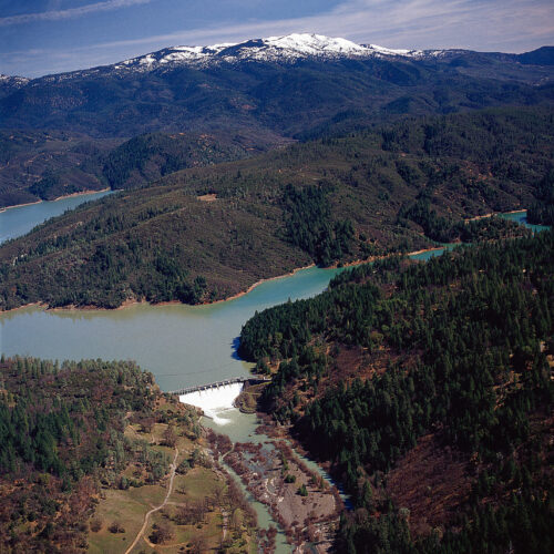
“During the throes of the COVID-19 pandemic, PG&E was conducting a routine inspection of a hydroelectric dam on Northern Mendocino’s Eel River — when it discovered a problem. A key component in their power generation system needed a pricey fix — one that could cost the utility up to $15 million. The power company already knew that the Potter Valley Project, which included two dams on the Eel River, didn’t balance economically. It barely powered 750 homes and was expensive to operate. So when no buyers came forward to offload the 100-year-old hydroelectric system, PG&E submitted an application to the federal government to decommission the project — in other words, take down the dams for good. “ PG&E likes dams, right? I mean, we are a hydro generating company,” said Janet Walther, director of hydro licensing and compliance for the company. “However, there are times, as Potter Valley is one of those, where a dam may no longer make sense.” … ” Read more from KQED.
FERC will hold public scoping sessions in Eureka next month on the proposed decommissioning of PG&E’s dams on the Upper Eel River
“Humboldt County residents will have a pair of chances next month to weigh in on the future of the Potter Valley Project, with federal regulators holding public meetings at Eureka’s Wharfinger Building as part of their environmental review of PG&E’s plans to decommission the project. The Federal Energy Regulatory Commission (FERC) will hold an evening session Sept. 15 and a daytime session Sept. 16, giving members of the public a couple of chances to say their piece and have their comments entered into the formal record. PG&E’s plans to surrender and decommission the Potter Valley Project — a defunct hydroelectric system that diverts water from the Upper Eel River to the headwaters of the Russian River — have become something of a political football in recent months. U.S. Secretary of Agriculture Brooke Rollins seems determined to blow up the “Two-Basin Solution” developed under U.S. Congressman Jared Huffman. … ” Read more from the Lost Coast Outpost.
Restoring access to adventure: M6 Road Repair
“In Northern California’s Mendocino National Forest, the Forest Road M6 winds along the headwaters of the popular Eel River. For anyone traveling through the western and northern reaches of the forest, M6 is a familiar route. Campers rely on it to reach Lake Pillsbury. Hunters follow it toward the B‑Zone deer country. And adventurers use it to get to the rugged hiking trails near Bloody Rock in the Snow Mountain Wilderness. It is one of the forest’s main travel corridors, carrying people into some of its most beautiful and remote places. Yet in 2023, powerful winter storms swept through the forest. The storms compounded the effects of previous wildfires — causing erosion, weakening trees, and destabilizing many forest roads. Above the M6 Road, the slope gave way, pushing earth downhill and collapsing part of the roadway. Over the next three years, the forest’s in-house equipment operator reopened the road after each winter. While the temporary road repairs put a band-aid on the situation, a permanent repair was absolutely needed to fully restore access. … ” Read more from the U.S. Forest Service.
Lawsuit filed against timber plan to protect salmon habitat in Mendocino County
“A hearing has been scheduled in Ukiah later this month for a lawsuit filed in an effort to protect critical salmon habitat in Mendocino County, the Friends of Dutch Charlie Creek reported. In a press release this week, the group reported that it had “filed a lawsuit against Cal Fire to stop the destruction of one of the most critical endangered coho salmon habitats left in California, (describing the litigation as seeking) to halt the recently approved ‘Hot Tuna’ and ‘Lincoln Logs’ timber harvest plans which threaten to imminent harm to the fragile Dutch Charlie Creek watershed and its prime coho habitat.” … The Friends of Dutch Creek describe it as “one of the last reliable spawning and rearing habitats for California’s endangered coho salmon. Surveys consistently show Dutch Charlie having the highest coho redd density of all tributaries to the South Fork Eel River, which is home to the most consistently abundant coho population in California, (and that its) habitat is key to the continued recovery of this population.” … ” Read more from the Mendocino Beacon.
SIERRA NEVADA
Saving Lake McCumber: Community members fight to preserve a small dam in Shingletown
““It’s a lovely spot. The grounds are gorgeous, pristine.” That’s what Isabel Klopchic, an attorney and Shingletown resident, said as she looked out over the water of the McCumber reservoir a few weeks ago. The lake is located in Shingletown about 45 minutes east of Redding. Next to Klopchic, her husband, Lassen Pines Mutual Water Company President Kim Walters, shared some of the history of the reservoir. Nearby, Shasta County Supervisor Chris Kelstrom pointed out an osprey as it dove into the deep blue water to catch a fish. The McCumber reservoir, often called “Lake McCumber,” is a small body of water created by the McCumber Dam, which sits at the North Fork of Battle Creek in Shasta County. It’s part of the broader Battle Creek Hydroelectric Project currently owned and operated by PG&E. The lake, and the quiet forested Shingletown neighborhood that surrounds it, are located close to Lassen National Park. PG&E’s license for the hydroelectric project, which originally generated power using dams, canals and pipes, expired this year. The company has decided not to renew its license. Since no group or entity has volunteered to take over ownership of the project, the McCumber Dam, along with the North Battle Creek Dam, could be removed in the years to come — quickly draining the existing reservoir and fundamentally changing the community that surrounds it. … ” Read more from the Shasta Scout.
Caldor Fire 5 years later: The destructive wildfire that forced South Lake Tahoe evacuations
“Five years ago, the Caldor Fire raced through the Foothills and Sierra, forcing historic evacuations, burning many homes to the ground and injuring several people, including firefighters. Rapid flames tore through El Dorado, Alpine and Amador counties in what is California’s 18th most destructive wildfire in the state’s recorded history. According to Cal Fire, the fire destroyed 1,003 structures and damaged 81 more. It also left 16 firefighters and five residents injured. The Caldor Fire posed a relentless challenge for firefighters as it had plenty of vegetation to burn, spreading eastward to the point where it forced the entire city of South Lake Tahoe to evacuate. The last time the city evacuated was due to the Angora Fire in 2007. … ” Read more from KCRA.
NAPA/SONOMA
Napa County supervisors approve 55% reduction in groundwater fees
“Napa County’s fees this year for groundwater sustainability will hit groundwater users in the Napa Valley subbasin about half as hard as initially planned. The Napa County Board of Supervisors on Tuesday, Aug. 11, unanimously voted to adopt the new fee structure for the fiscal year that began July 1, introducing user fee rates about 55% lower than the maximum rates adopted in December. The new rates vary depending on whether the user is agricultural, self-supplied or a public water system … The fee payments will be added to property tax bills due in December 2026 and April 2027, according to county officials. Generally, the fees won’t apply to properties served by the water systems in Napa, St. Helena, Calistoga or Yountville. … ” Read more from the Santa Rosa Press Democrat.
BAY AREA
Strong El Niño may bring record sea level and coastal flooding to Bay Area
“Derek Bentley’s San Rafael karate studio flooded in January, when a heavy storm hit during one of the highest tides of the year. Several inches of water rose from under the foundation and filled the building from the inside, soaking the karate mats so thoroughly that they squirted water when Bentley stepped across them. “We were closed for about a week after the flood,” Bentley said. “Then we opened, but we used air dryers and some of the mats were still wet, and we had no carpet for a couple months.” Now he fears a bout of déjà vu could be in his future if very strong El Niño conditions steer strong storms toward the Bay Area and once again flood his dojo. … ” Read more from KQED.
SEE ALSO: Bay Area communities step up flood preps as CA could face ‘historic’ El Nino winter, by ABC 7
California Coastal Commission approves renovation of Stinson Beach public area
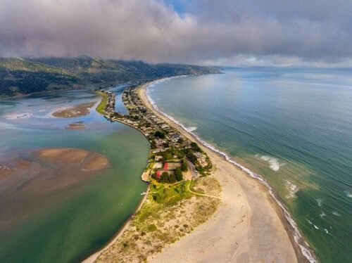 “The California Coastal Commission on Thursday approved a proposal by the National Park Service for the renovation of Stinson Beach’s public areas, allowing the project to move forward with permitting and construction. Proposed changes include renovations to existing facilities and adjustments to three public parking lots, as well as entrance roads, drainage systems and pedestrian paths. The renovation will also include nature-based sea-level adaptation measures such as restoration of dunes, a floodplain and native vegetation. The popular Marin County oceanside destination attracts about 600,000 visitors a year, according to a 2023 study by Point Blue Conservation Science, a nonprofit environmental research organization based in Marin County. According to a study prepared for Marin County’s Stinson Beach Adaptation and Resilience Collaboration community initiative, a significant amount of land is projected to be lost as sea levels rise. … ” Read more from Local News Matters.
San Francisco’s $17.8 billion plan to save its waterfront hits new hurdles
“Raising the Ferry Building. Levees along Mission Creek. “Living” seawalls that integrate with marine life. San Francisco has a sprawling $17.8 billion plan to protect its waterfront against rising seas and earthquakes over the coming decades. But it will cost more and take longer than previously estimated, and it could be years before the megaproject gets federal approval. The U.S. Army Corps of Engineers and the Port of San Francisco in late July released a final study and recommended plan for adapting a 7.5-mile stretch of waterfront — from Fisherman’s Wharf to south of Islais Creek — to coastal flooding and sea level rise of up to roughly 9 feet by 2140. Without taking any action, sea level rise could cause roughly $23 billion in damage in San Francisco in about the next century, impacting 23,000 people and 3,400 jobs, according to the Port. The federal government may ultimately pay up to 65% of the project cost if approved, according to the Port. … ” Read more from the San Francisco Chronicle.
Where Bay Area cities stand on data centers
“During her Aug. 7 town hall meeting at Oakley City Hall, state Assemblywoman Lori Wilson discussed — among other things -– local concerns around data centers. She spoke on regulations that would keep massive data centers from being built in California, including transparency laws on the level of water use and mandates on the use of recycled water. While she was against what she called “data center farms,” Wilson was for much smaller facilities that are attached to businesses and use much less water and fewer resources. Locally, different cities have taken different approaches to data centers based on feedback from their residents. … ” Read more from the Brentwood Press.
CENTRAL COAST
Los Olivos must choose its wastewater future before someone else does
Mike Brady writes, “Fifty-four years ago, Santa Barbara County designated Los Olivos as a “Special Problems Area” because of nitrate intrusion into the groundwater. The purpose of that designation was to limit more sewage going into the ground from both residential and commercial development. Since 1972 the town and surrounding community that exists today has more than tripled in size and in sewage disposal into the groundwater aquifer. The “Special Problems Area” designation did not control growth. Both the county’s and the state Regional Water Quality Control Board’s positions have been that if the community doesn’t eliminate nitrate intrusion via the current septic system of sewage disposal, they will impose a solution. … ” Read more from Noozhawk.
SAN DIEGO
Inspection deems Lake Hodges Dam unsatisfactory in 2022, leaving residents and advocates pushing for rebuild
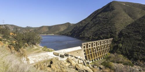
“The Lake Hodges Dam is 108 years old, and residents who live nearby say they are concerned about the impacts of the water levels. Mary Ellen Leahy has lived near Lake Hodges for the past 40 years. Her family grew up doing activities near the lake. “When we first moved here, it was referred to in the paper as the jewel of North County because of its beauty, it’s natural beauty, the wildlife and its recreational opportunities,” Leahy said. But things have changed since 2022. That’s when, according to the City of San Diego, an inspection deemed the dam unsatisfactory. The city found concrete deterioration, cracks, rebar exposure, and a hole in the dam face. The city made immediate repairs, and the water level was restricted due to a safety order. … ” Read more from Channel 10.
Along the Colorado River …
Here’s how Lake Mead water crisis could affect California
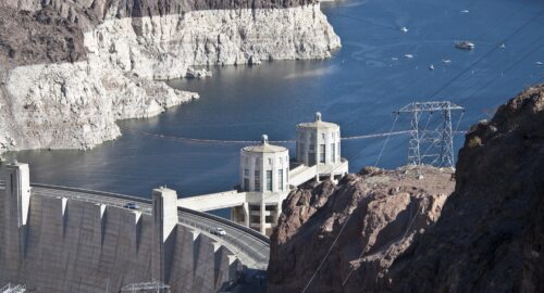
“Lake Mead, located in southern Nevada and fed by the Colorado River, is the largest reservoir in the U.S. and a critical water source for Southern California. According to water officials, the lake reached a new record low last week, surpassing the previous low recorded in 2022. “It’s scary. I won’t lie,” said Bill Hasencamp, manager of Colorado River resources for the Metropolitan Water District of Southern California. Hasencamp said conditions briefly improved in 2023 because of above-average snowfall and runoff, but drought conditions have since returned. “We got lucky in 2023 … it was a wet year. There’s a lot of snow and it looked like things were improving. The reservoirs went up, but since that time, the snowpack has been pretty dismal, and this particular year was the lowest snow every quarter in the upper basin,” Hasencamp said. … ” Read more from ABC 30.
Water fight moves to next phase under federal 10-year framework
“The long-running battle over how to divide the shrinking Colorado River for drinking water and agricultural use took a significant step forward last month, but it did not produce the agreement Western water managers had hoped for. The U.S. Bureau of Reclamation released a final environmental impact statement July 31 establishing a new framework for managing Lake Powell and Lake Mead through 2036. The framework is designed to give federal officials flexibility to respond to changing water conditions while establishing limits on how the two reservoirs can be operated. What it does not do is settle the fundamental dispute among the seven Colorado River Basin states, including California, over who should bear the burden of future water shortages. … ” Read more from the Acorn.
Crayfish pose new Grand Canyon invasion as they spread through Colorado River
“Crayfish have joined the list of non-native species massing below Glen Canyon Dam for a potential invasion of Grand Canyon, raising alarms from conservationists who want to protect pristine tributary streams in the national park. National Park Service biologists say the invasive species that has caused ecological havoc in other streams has now shown up by the thousands in agency nets below the dam. They netted more than 3,000 so far this year in a short stretch of the Colorado River where last year they found just over two dozen, Park Service Colorado River Coordinator Nicki Gibney told members of an advisory group that works to minimize the dam’s environmental impacts. … ” Read more from Arizona Central.
Arizona cities are cutting back on Colorado River water use. Federal money makes it easier
“Across the Phoenix area, cities and towns are preparing for a future with less water from the Colorado River. Arizona is working on a deal with neighboring states and the federal government that would volunteer to cut back on the state’s take from the Colorado River. Throughout the Valley, local governments are signing agreements with the federal government to make it happen. The Bureau of Reclamation, which manages the West’s reservoirs and dams, has plans to pay cities from Gilbert to Glendale to use less of the Colorado River. In recent years, sweeping cuts to water allocations in Arizona and some other states that use the Colorado River have been made possible with big chunks of federal money. The Biden administration set aside $4 billion from the Inflation Reduction Act for Colorado River work. … ” Read more from KJZZ.
Arizona water imports compared: Sea of Cortez desalination vs atmospheric water harvesting
“Arizona’s water future may hinge on a choice between two radically different ways of importing moisture into one of the driest regions of the United States: moving seawater inland through a large centralized desalination system, or producing drinking water close to where people live by extracting humidity from the atmosphere. A study by E. Day and P. Westerhoff, published in npj Clean Water, compares these strategies through the lens of Arizona’s growing water stress. The analysis places a familiar megaproject—the proposed use of Sea of Cortez seawater—alongside a more distributed and technologically novel approach: atmospheric water harvesting. The comparison arrives as the state faces intensifying pressure from population growth, prolonged drought, groundwater depletion and a changing climate. … ” Continue reading from Bioengineer.
Residents urged to turn off irrigation systems as rain continues to roll through Las Vegas
“The Southern Nevada Water Authority (SNWA) is urging residents to turn off their landscape irrigation systems as the valley continues to see rainstorms throughout the rest of the week. Las Vegas faces a 50% chance of thunderstorms Thursday afternoon and another 50% chance Friday, with rain possibly lingering into Saturday, according to the National Weather Service. Nighttime temperatures will remain in the high 70s all weekend, NWS officials add. This comes after Southern Nevada has already seen several days of stormy weather. … ” Read more from Channel 5.
Glen Canyon Dam hydropower: What’s it good for?
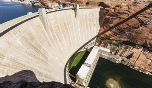 “Glen Canyon Dam truly is a monumental structure, a 726-foot tall, 5-million-cubic-yard concrete plug that attempts to control and harness the tempestuous waters of the mighty Colorado River. It and the reservoir behind it serve as a water savings account that helps the Upper Basin states comply with the Colorado River Compact during dry years; they capture millions of tons of silt each year that would otherwise flow downstream and fill up Lake Mead; they provide a surface on which boaters can play; and the dam’s hydroelectric turbines are among the West’s largest power plants. Now climate change-induced aridification and overconsumption has muddled the dam’s ability to serve its intended purposes aside from silt capture. Its savings are depleted, many of the boat ramps are unusable, and hydropower production has declined along with reservoir water levels. The Bureau of Reclamation is now struggling to keep the dam viable, sort of, by trying to keep Lake Powell’s surface level from falling below 3,500 feet. This avoids reliance on the lower river outlet works, which are not designed for sustained use. But it also allows the dam to continue producing electricity. … ” Read more from the Land Desk.
Colorado groups cut water deal to keep fisheries, rafting and recreation afloat amid ‘catastrophic drought’
“One of Colorado’s most popular rivers for rafting and angling is getting a last-minute boost of water to support fishery health and recreation through the tail end of the drought-stricken summer. Flows on the Arkansas River have trended toward record lows most of summer, according to state data. As water levels have continued to drop, the Southern Colorado Water Conservancy District approved a cooperative effort Aug. 6 to dedicate 2,500 acre-feet — or 815 million gallons — of water to the Upper Arkansas River. “We’ve known that things were going to be bad this year on our rivers this late in summertime for a long time, but it takes the kind of conditions we’re seeing for people to really get creative about how to use some water,” said Blake Mamich, the program director for the Colorado Water Trust. “In this case, we were able to do a quick deal and get some water in the river.” … ” Read more from Vail Daily.
In national water news today …
Federal water infrastructure funding faces steep proposed cuts
“A new CRS report on federal water infrastructure programs examines the Trump administration’s proposed fiscal year 2027 budget cuts and their collision with decades of unmet infrastructure needs, proposing steep reductions to programs that have long underpinned American water systems. The nation faces a combined 20-year need for wastewater and drinking water infrastructure exceeding $1.2 trillion, yet the budget would slash core funding mechanisms by roughly 79 percent for the Clean Water State Revolving Fund and 63 percent for the Drinking Water State Revolving Fund, calculated against the elevated Infrastructure Investment and Jobs Act (IIJA) funding levels of $2.603 billion annually through 2026 for each revolving fund. These cuts threaten to reverse gains made by the 2021 Infrastructure Investment and Jobs Act, which supplied those baseline amounts, plus targeted one-time investments, including $3.0 billion for lead service line replacement and $800 million for emerging contaminants. … ” Read more from Legis 1.
El Niño may push global warming to 2c or higher in the short term
“A powerful El Niño already beginning to roil weather around the world may push the monthly global average temperature past 2C of warming for the first time on record, according to projections published by a University of Miami-based ocean and atmospheric research center. The probability that a single month in early 2027 passes 2C has reached 35% to 40%, said Ben Kirtman, dean of the Rosenstiel School of Marine, Atmospheric, and Earth Science at Miami. “That’s a large probability,” he said. “That’s really large, and maybe that’s what people don’t appreciate.” The odds of a month that’s 2C hotter than pre-industrial levels increased significantly in recent weeks as meteorologists upped their estimates for the current El Niño, which is likely to be the strongest in modern history. The hot El Niño is coming on top of a possible acceleration of global warming that scientists are still trying to unpack. … ” Read more from Bloomberg.

