
Several news sources featured in the Daily Digest may limit the number of articles you can access without a subscription. However, gift articles and open-access links are provided when available. For more open access California water news articles, explore the main page at MavensNotebook.com.
On the calendar today …
- WEBINAR: SGMA-Ready Crops for the San Joaquin Valley from 11am to 12pm. How is SGMA implementation going, what successes have we seen, and what’s next for the San Joaquin Valley? Join us on Tuesday, July 28 for a presentation and panel discussion about all these questions, with a special look at whether SGMA-ready crops could aid the farmland transitions currently underway in the valley. Click here to register.
- MEETING: WIIN Act Quarterly Meeting on the Long-Term Operation of the Central Valley Project and State Water Project from 1pm to 3pm. Reclamation will hold a quarterly meeting to provide an update on the Long-Term Operation of the Central Valley Project and State Water Project, pursuant to the Water Infrastructure Improvements for the Nation Act. Microsoft Teams meeting: https://teams.microsoft.com/meet/284429812939388?p=N555WKFsS2Ng5VWpsL Meeting ID: 284 429 812 939 388 Passcode: e4RE7SL6
- WEBINAR: Interweaving Traditional Knowledge Roundtable Series: Examples of Successful Co-Governance and Co-Management from 2pm to 3:30pm. Co-hosted by the Delta Stewardship Council, the Shingle Springs Band of Miwok Indians, and the California Indian Environmental Alliance, this three-part series will bring together Tribal Elders and leaders, agencies, and scientists to share experiences, discuss challenges, and explore practical approaches to interweaving Traditional Knowledge, management, and science. This is the second of three workshops. The topic is Tribal Beneficial Uses: An Explainer and Applications. View the flyer. View the agenda. Register via Eventbrite. To attend virtually on Zoom, register here.
In California water news today …
FERC OFF: Federal agency tosses Southern California water agency’s bid to take over Eel River water rights
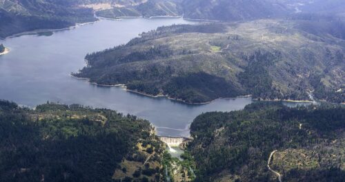
“This morning, the Federal Energy Regulatory Commission – the agency overseeing Pacific Gas and Electric’s effort to decommission two dams on the upper Eel River – told a Southern California water agency that its late bid to take over the project, along with the water rights that come with it, will not be allowed to proceed. In making its decision, FERC staff told the Elsinore Valley Municipal Water District that it presented no compelling argument as to why it should be allowed to intervene in the case more than eight months after the deadline to do so had passed. “[T]he District failed to demonstrate that good cause exists to grant its untimely motion to intervene because it did not provide any explanation for the untimeliness of its motion,” reads the commission’s denial. “Therefore, the District’s late motion to intervene is denied.” … ” Read more from the Lost Coast Outpost.
SEE ALSO: A Southern California Water Agency Tried to Take Over Two Eel River Dams. Federal Regulators Just Said No., from Active NorCal
California drought caused irreversible ground sinking in Sacramento Valley
“A new study of groundwater in California’s Sacramento Valley shows that the ground sank faster than expected during the 2020-2022 drought due to heavy groundwater pumping, resulting in less water storage capacity in the aquifer. The authors of the study published Monday in the Proceedings of the National Academy of Sciences say the damage to the aquifer may be long-term and irreversible. Land subsidence occurs when excessive groundwater is withdrawn from rocks and sediment, causing the ground to sink, according to the U.S. Geological Survey. As groundwater is depleted, aquifers become more susceptible to compaction because the water no longer provides enough underground pressure to support the overlying land. “As global demand for groundwater intensifies in response to climate change, its ability to act as a buffer against surface water variability becomes increasingly critical,” the authors write. “A growing concern, however, is that intensive exploitation of groundwater resources can damage aquifer systems and hence threaten future groundwater availability.” … ” Read more from the Courthouse News Service.
California scientists find early warning sign of irreversible groundwater damage
“Some farming towns in California’s Central Valley have sunk by more than 11 feet in recent years because of groundwater pumping, the extraction of water from underground aquifers using wells and electric pumps for drinking, farming and industry. While some land subsidence is temporary, excessive pumping can cause aquifers to permanently collapse, reducing storage capacity and damaging homes, roads, bridges and canals. New research from UCLA and Caltech has outlined a way to detect when temporary land subsidence becomes permanent and irreversible. The research, published this week in Proceedings of the National Academy of Sciences, uses satellite imagery to identify the “abrupt transition to irreversible damage.” Researchers hope this will give decision makers new tools to keep an eye on water resources. … ” Read more from KQED.
Groundwater agencies argue against new proposed state fees
“A proposed fee of between $50,000 and $250,000 charged to groundwater agencies that apply for a so-called “good guy” exemption will be discussed Thursday at 1 p.m. during a state Water Resources Control Board workshop. The fee is part of a proposal made by Water Board staff to cover the cost of evaluating groundwater plans that agencies feel adequately protect aquifers from depletion. Groundwater basins must reach balance by 2040, per the Sustainable Groundwater Management Act (SGMA). A “good guy” exemption would only be sought by individual groundwater agencies when a subbasin is placed on probation by the Water Board for having an inadequate plan. Probation comes with requirements that farmers meter and register wells at $300 each, and pay a $20-per-acre-foot fee to the state – on top of existing fees paid to groundwater agencies. … ” Read more from SJV Water.
An exclusive interview with outgoing DWR Director Karla Nemeth
 “California Department of Water Resources (DWR) director Karla Nemeth left the department last month after nearly nine years of service. Before she takes over as the director of the Association of California Water Agencies (ACWA), we sat down with her to talk about how DWR changed during her tenure, what (still) keeps her up at night, and what advice she’d offer California’s next governor. Why has managing water at DWR become so complicated?DWR was established in 1956, after a devastating flood in northern California. World War II veterans were drafted to engineer a huge system that would deal with flooding and move a lot of water vast distances for water supply. So a very linear era with narrow objectives birthed both the State Water Project and the department. We live in a very different world today. With extreme weather and older infrastructure, both day-to-day and season-to-season management are much harder, and the cumulative damage to groundwater basins and river systems over the last 100 years is catching up with us. The stakes are just off-the-charts. … ” Read more from the PPIC.
Hurricane Genevieve becomes a monster Category 5 while Fausto slices north of Hawaii
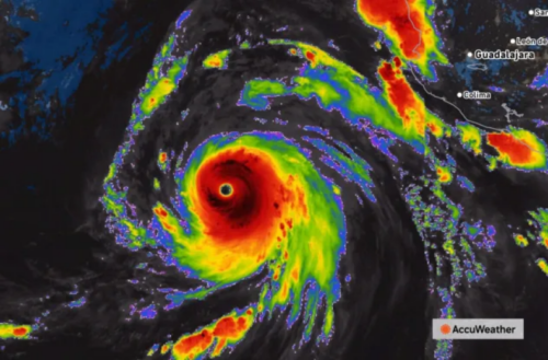 “The eastern and central Pacific have become very active, with Hurricane Genevieve becoming the season’s first Category 5 while churning off the coast of Mexico, and Tropical Storm Fausto set to slide by the Hawaiian Islands this week. Meanwhile, Typhoon Dolphin, north of the Marshall Islands, appears to be rapidly strengthening. … A tropical depression formed on the morning of July 24, well off the coast of Mexico, and became Tropical Storm Genevieve several hours later. A day later, on Saturday, Genevieve became a hurricane. Twenty-four hours later, on Sunday, Genevieve rapidly intensified and became a powerful Category 4 hurricane with maximum sustained winds of 155 mph. During the overnight hours on Sunday, Genevieve’s maximum winds reached 160 mph — a Category 5 hurricane. “While eastern Pacific Major Hurricane Genevieve poses no direct threat to land, it has become the most powerful hurricane in the waters surrounding North and Central America this year and the first Category 5 hurricane since Kristy in 2024,” AccuWeather’s Lead Hurricane Expert Alex DaSilva said. … ” Read more from AccuWeather.
How good policy and prudent planning kept California’s drinking water safe from lead
 “When it comes to drinking water, few words raise concern as quickly as lead — especially for parents of young children. That concern is well-founded: lead is a toxic metal with no safe level of exposure, and drinking water has historically been one of several pathways through which people could be exposed. But in some regions of the United States, lead was once a common construction material because it was durable and easy to work with. In particular, it was often used in service lines, or the pipes that connect water mains in the street to homes and buildings. That’s why the U.S. Environmental Protection Agency (EPA) recently required water systems nationwide to inventory the number of lead service lines in their water systems — a first-of-its-kind effort to identify where lead pipes may still be delivering drinking water to homes. California completed that inventory this year and the result may surprise many people: no lead service lines were found among millions of water service connections statewide. … ” Read more from the State Water Board’s Ebb and Flow.
Passive design significantly reduces indoor water use, pilot program demonstrates
“The average U.S. family uses 320 gallons of water per day, about 70% of it indoors, according to the Environmental Protection Agency. What if that figure could drop dramatically – with little to no impact on consumers? Programs such as tiered pricing and smart water meters help drive conservation. But the 50L Home Coalition, a project of the World Business Council for Sustainable Development, is adopting a different approach: energy-efficient and well-designed appliances and more effective consumables like laundry and dishwashing detergents. The 50L coalition seeks to help urban residences achieve an average of 50 liters (about 13 gallons) of water consumption per person per day. The vision is to make those 50 liters feel like 500 liters. This way, consumers will save water without compromising comfort and quality of life. This renewed focus on consumers is expected to help adoption. “50L starts on the premise that water efficiency scales fastest when it improves everyday living,” said Neil Patel, manager of the coalition. “Homes work better, routines become simpler, and lower water use becomes the natural outcome of better design, not behavioral effort or sacrifice.” … ” Read more from Civil Engineering Source.
Control, not eradication: Managing invasive plants in the Delta
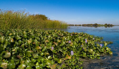
“Invasive aquatic vegetation has become one of the Sacramento-San Joaquin Delta’s most persistent challenges, affecting ecosystems, navigation, water operations, and public safety. The Delta’s mild climate, altered waterways, high nutrient levels, and complex network of sloughs and rivers create ideal conditions for non-native aquatic plants to spread rapidly and become difficult to control. The extent of the problem varies widely from year to year, driven by seasonal temperatures, drought conditions, and river flows. Historical estimates for water hyacinth alone have ranged from fewer than 500 acres to more than 2,500 acres, while submerged weeds such as Brazilian waterweed can cover even larger areas. During recent drought periods, including 2013–2015 and 2021–2023, remote sensing data showed sharp increases in submerged aquatic vegetation as warm, slow-moving water created especially favorable growing conditions. As these invasive plants expand, they can transform the Delta’s marsh habitats by slowing water velocities, increasing water clarity, providing cover for invasive fish, and reducing the open, turbid-water habitat needed by native pelagic species such as Delta smelt. … ” Read more from Maven’s Notebook.
Restoring resilience: Reviving rivers with in-stream restoration
“Logging, mining, and agriculture have drastically altered California’s historic waterways, significantly impacting the species that depend on them. These practices all contributed to straighter, more incised, and simplified stream channels. Large scale mining operations dredged much of the critical spawning gravel used by salmonids, often removing it from rivers and depositing it onto floodplains. This frequently left behind long, deep pools with little suitable riffle habitat for spawning. In heavily logged areas, splash dams and timber harvest practices destabilized streambeds and created large accumulations of debris in smaller streams and tributaries that often acted as fish barriers. … ” Read more from FishBio.
Warming seas have less oxygen. California experts say that’s really bad.
“As the brewing El Niño cooks the Pacific Ocean this summer, California scientists warn that the global seas are losing a vital resource due to climate change: oxygen. In a recent study published in the journal Limnology and Oceanography, scientists from UC San Diego’s Scripps Institution of Oceanography and several partners argue that the rate of oxygen loss in the ocean and freshwater is approaching an “unsafe space” with irreversible impacts. “The loss of dissolved oxygen could impact nearly every aspect of aquatic ecosystems, from the food they provide us to the sense of place and meaning that we draw from them,” paper co-author Erica Ferrer, a Scripps Oceanography alumna and postdoctoral scholar at UC Santa Barbara’s National Center for Ecological Analysis and Synthesis, told SFGATE by phone Thursday. “It also seems likely that widespread changes in dissolved oxygen could impact our climate, including driving the additional production of greenhouse gasses.” … ” Read more from SF Gate.
California pistachio crop expected to shrink sharply following challenging growing season
“California pistachio growers could be facing one of the smallest crops in years after an unusually warm spring disrupted pollination across much of the Central Valley. The outlook was the focus of a recent episode of the AgNet News Hour, where crop advisor and pistachio industry leader Rich Kreps discussed the challenges shaping the 2026 crop and what growers can expect moving forward. Kreps said the extreme heat experienced during bloom created significant pollination issues, particularly in the southern San Joaquin Valley. Because pistachio pollen becomes less viable when temperatures climb above approximately 85 degrees during bloom, many orchards are now showing unexpectedly high percentages of blank nuts. “We went from over 1.5 billion pounds last year,” Kreps said. “I’ve heard estimates ranging from around 900 million pounds down to as low as 600 million pounds. We’ve almost dropped to a third of the market from last year.” … ” Read more from AgNet West.
GO-Biz issues memo backing California Forever
“The California Governor’s Office of Business and Economic Development (GO-Biz) sent out a memo to lawmakers and local leaders on Friday supporting California Forever’s Solano Shipyard and Solano Foundry proposals. The memo, from Director Dee Dee Meyers, said the projects clearly reflect the state’s current opportunity to attract more advanced manufacturing investment. “GO-Biz believes this is a moment for California to double down on the economy of the future — and to show the country and the world that we remain open for business,” the memo reads. “The path forward will require collaboration among state and local government, labor, business, community organizations, and private investors. This memo is meant to frame that conversation — not to prescribe a specific path or outcome.” … ” Read more from the Vacaville Reporter.
SEE ALSO: The Shipyard California Could Not Build, from Dredge Wire
In commentary today …
C-WIN: The unethical choice for the State Water Resources Control Board
Carolee Krieger writes, “In California, the State Water Resources Control Board (Water Board) has regulatory authority over water rights, water quality, and drinking water. It is unethical for Water Board members to have direct ties with the entities they regulate. That’s why the appointment of the newest Water Board member—Jared Blumenfeld—is deeply problematic. Blumenfeld previously served as Secretary of the California Environmental Protection Agency (CalEPA), where he and other gubernatorial appointees negotiated with regulated companies and water districts to develop. Blumenfeld has made it clear that he will vote to approve those very agreements later this year. He is also certain to support other boondoggle projects advanced by Newsom and the water industry, including the $60–$100 billion Delta Conveyance Project and the $7 billion Sites Reservoir. While Blumenfeld’s appointment may be technically legal, it is an affront to the idea of independent regulatory decision making, and very much in line with the Newsom—and Trump—playbooks. … ” Read more from C-WIN.
In regional water news and commentary today …
NORTH COAST
Engineers blew up 4 dams on a dying river. Now the salmon population is exploding.
“The ancient and beautiful Klamath River runs along the border of southern Oregon and Northern California. For millions of years, it was a fertile breeding ground for fish—one of the largest salmon runs in the country, in fact—a lifeline for wildlife and vegetation in the area, and more modernly, a source of food for local tribes. But in the early 1900s, what was then known as the California Oregon Power Company (COPCO) built a series of hydroelectric dams that would harness the river’s power and turn it into electricity that could be sold. It decimated the area. The dams cut the salmon off completely from more than 400 miles of open river. They also degraded water quality and supported the growth of toxic algae. … ” Read more from Upworthy.
At Redwood National Park’s newest gateway, the Yurok Tribe tells its own story
“Hundreds of thousands of people drive through the small town of Orick each year on their way to Redwood National and State Parks, occasionally stopping to grab last-minute supplies or get a look at the herds of resident elk. But starting Aug. 1, travelers will have a new reason to stop and learn about the region’s tribal history. The Yurok Tribe is opening ‘O Rew Redwoods Gateway, a new recreation area at the southern entrance to the parks offering accessible walking trails, picnic areas, scenic overlooks and interpretive exhibits that tell the story of the redwood forest through the Yurok perspective. … ” Read more from SF Gate.
California redwoods gateway is returned to Indigenous tribe. ‘That’s healing our people too’
“This fog-shrouded patch of coastal forest in the heart of Yurok Country was tended by the tribe for millennia. But in the Gold Rush era it was taken away and, later, used by the logging industry, reshaping the landscape. Now, as the land heals from the scars of a long-running lumber mill, it has been returned to its original stewards, who will operate it as a public gateway to Redwood National and State Parks about 50 miles south of the Oregon border. Save the Redwoods League last month conveyed the 125-acre property to the Yurok Tribe following a years-long project to restore the degraded industrial site to a diverse riparian habitat. It opens to the public Saturday as ‘O Rew Redwoods Gateway, which features interpretive exhibits and trails leading to old-growth redwood groves. … ” Read more from the LA Times.
Blue Lake proposes eminent domain solution to water tank dispute; landowner files suit
“This Tuesday, Blue Lake City Council will review items regarding the city’s water storage issues. Those items have to do with securing an agreement on an aging 400,000-gallon water tank located on local landowner Erin McClure’s property. City officials are proposing to enter into a process with Bender Rosenthal to compel the sale of the property on which the tank sits. McClure told the Times-Standard that she filed suit against the city on Friday and her attorney, Allison Jackson of Harland Law Firm, served city representatives with papers on Monday. City staff says that, following the dissolution of a “tentative lease agreement” with McClure in early July, the city is initiating negotiations which would compel the sale of the plot on which the water tank stands and create easements for road access and a water line in perpetuity, purchasing only a fraction of an acre through a negotiated process that will involve independent land assessment and thorough negotiations with the landowner. McClure has vowed to fight the city, saying that the city “hasn’t paid rent in 15 years.” … ” Read more from the Eureka Times-Standard.
Mendocino authorities bust dozens of illegal cannabis grows, uncover forced labor
“Authorities in Mendocino County busted several illegal cannabis grows this month and found evidence of forced labor abuses, the Sheriff’s Office said Saturday. Between July 1 and Friday, deputies with the Lake and Mendocino county sheriff’s offices served multiple search warrants at unlicensed cannabis cultivation sites in the Covelo, Laytonville, Potter Valley and Redwood Valley areas. The operation targeted more than 30 sites, according to the Sheriff’s Office. Investigators documented numerous water diversions and found extremely dangerous pesticides near local waterways and sensitive habitat areas, the Sheriff’s Office said. Law enforcement officials also found evidence of pesticides banned in the U.S., specifically foreign-language labeled containers that are prohibited. The pesticides raised serious concerns for residents, wildlife and downstream natural resources. … ” Read more from Local News Matters.
SIERRA NEVADA
Round Valley Meadow restoration to begin in mid-August
“Meadow restoration at Round Valley will begin in mid-August 2026. This project will use low-tech process-based restoration (LTPBR) methods such as building beaver dam analogs (BDAs) and post-assisted log structures (PALS) to remedy incised and degraded channels within the meadow. All work will be done by hand using hand tools, including chainsaws which may be heard from hiking trails around Castle and Round Valley. The trees being cut are encroaching conifers from within and on the perimeter of the meadow and will be used as building material for the BDAs and PALS. Implementation is expected to last about two weeks during August of 2026 with additional rounds of restoration expected in summers of 2027 and 2028. … ” Read more from the South Yuba River Citizens League.
This small Sierra meadow helps supply California’s drinking water. Crews are bringing it back to life.
“Mountain meadows cover a sliver of the Sierra Nevada, but they do outsized work for the rest of California. Crews are proving that this summer at Pickel Meadow, just north of Yosemite, where a restoration project is reshaping 3 miles of the West Walker River and its floodplains. The trouble traces back 20 years, when Caltrans built a berm after a nearby landslide. The structure squeezed the river into a narrow channel that carved deep banks, cut water off from the floodplain and left much of the meadow dry. Removing it is the centerpiece of the work. Sarah Hecocks, associate director of the headwaters conservation program for the nonprofit American Rivers, said the fix is meant to last. “We’re restoring the natural hydrology that allowed Sierra meadows to thrive for thousands of years, so the meadow can sustain itself with very little long-term intervention,” Hecocks explained. … ” Read more from Active NorCal.
SACRAMENTO VALLEY
A new climate-resilient, carbon stable forest emerging in Camp Fire burn zone
“Outside the town of Concow in the middle of a high-severity burn zone that lost nearly 100 percent of the trees after the 2018 Camp Fire sprouts new life in the form of what researchers and project partners hope won’t just be a thriving open oak-dominated forest, but one much more adapted to future drought and wildfire. The Camp Fire burned through the dense mixed conifer forests of the Concow Basin and along tributaries to the North Fork of the Feather River killing nearly every tree in its path. With little to no seed source across the high-severity burn zone, the landscape, without intervention, will likely become a chapparal-dominated brushland. “For some parts of the Concow Basin, the Camp Fire was the third time in 20 years that it had burned at high severity. Given this fire history, plus climate change, it no longer seemed to make much sense to replant a conifer forest a third time in this foothill zone,” said Wolfy Rougle, planning and watershed program manager with the Butte County Resource Conservation District. “At least, not in the way it had conventionally been done in the past. We also understood that if we did nothing, what had been dense forest would most likely type-convert to chaparral, which nobody was excited about.” … ” Read more from the Sierra Nevada Conservancy.
A $2.37 million project is rebuilding salmon spawning habitat on the Feather River
“If you float or fish the Feather River in Oroville this summer, expect company. Heavy equipment is moving into the stretch between the Table Mountain Bridge and Bedrock Park for a habitat project aimed at giving salmon and steelhead a better place to spawn. The Department of Water Resources will place roughly 7,900 cubic yards of spawning gravel in the river while excavating and redistributing built-up streambed material to open access to existing side channels. Crews started mobilizing the week of July 20, with in-water work beginning the week of July 27 and running through the end of August. The gravel matters more than it might sound. Chinook salmon and steelhead trout depend on spawning habitat along the low-flow channel, where most of the activity happens. … ” Read more from Active NorCal.
NAPA/SONOMA
El Niño in Northern California: What Sonoma County could expect this year
“Forecasters are warning that a strong El Niño pattern is developing this year. KRCB’s Shandra Back speaks with Sonoma State University geology professor Nicole Myers about what the changing ocean and weather conditions could mean for the North Bay. KRCB: In Northern California, a lot of people, when they think of El Niño, think of lots of rain. Is that a fair expectation? MYERS: That is generally a fair expectation for El Niño. In very strong El Niños of the past, the Bay Area has gotten significant amounts of rain. So that is generally what we expect and generally what we would plan for. KRCB: And if we do end up with a wetter fall-to-winter season, what are some of the biggest impacts we could see here in Sonoma County, or have we historically seen? MYERS: We’d expect higher rainfall totals and the resulting flooding. Also, because the surface waters are warmer, in addition to higher precipitation, we expect more flooding along the coast and generally just slightly higher than normal sea levels. … ” Read more from NorCal Public Media.
BAY AREA
Marin Municipal Water District ordered to develop repair plan for dam
“The state has ordered the Marin Municipal Water District to develop a repair plan for Seeger Dam at the Nicasio Reservoir because an analysis showed declining performance. The California Division of Safety of Dams, or DSOD, has downgraded the dam to a “fair” rating from “satisfactory” because several components of the system are no longer up to modern standards. The water district has until Dec. 1 to submit its plan. “Based on their definition, there’s no existing dam safety deficiency that is recognized under normal operating conditions,” said Alex Anaya, engineering director at the Marin Municipal Water District. That means there is no immediate threat of failure or need to worry about shutting down Seeger Dam, Anaya said. However, the earthen dam’s underdrains, water stops, spillway reinforcement, anchorage and foundation are not working as they should, the state agency said. … ” Read more from the Marin Independent Journal.
River otters are hunting and drowning pelicans in a Bay Area lagoon
“Early one morning in 2018, Megan Isadore was observing wildlife at Abbotts Lagoon, along the northwestern edge of Point Reyes National Seashore, when she noticed something splashing in the water. At first, the co-founder of the River Otter Ecology Project thought it could have been anything — the area is home to a wide variety of species including thousands of waterfowl and shorebirds, as well as mammals such as weasels and bobcats. Isadore saw it was a brown pelican, which wasn’t unusual. The diving waterbirds liked to spend the nonbreeding season resting at the site. But this one’s wings were flapping in a way that struck her as abnormal. “I could see it struggling, but I couldn’t figure out why,” she told SFGATE over the phone.The movement all but stopped as the bird’s head was pulled underwater by an unseen force. Then, the head of a river otter popped to the surface, chewing. … ” Read more from SF Gate.
Deadline for cleaner wastewater extended by water board
“Two years ago, the Bay Area’s 40 publicly owned wastewater treatment agencies got some hard news. They had 10 years to upgrade their facilities to reduce pollutants entering the bay by 40%, at an estimated cost of $11 billion. At a Thursday meeting of the San Francisco Bay Regional Water Quality Control Board, a pathway was initiated for certain projects to get a deadline extension, if they qualify and are moving as quickly as possible. The 2034 deadline was established when the water board tightened the rules for issuing the permit required to discharge treated effluent into Bay Area waters. The move was in response to massive fish kills in 2022 and 2023 caused by consecutive algae blooms. “What we learned in 2022 is that it spread throughout San Francisco Bay because of the nutrients,” said Eileen White, executive officer for the board. “It was like a buffet for the harmful algal blooms. The algae was eating it up.” … ” Read more from Palo Alto Online.
Commentary: San Francisco isn’t ready for this year’s El Niño
Michael Redmond, a San Francisco-based writer and communications strategist focused on climate, technology and urban governance, writes, “Earlier this month, the National Oceanic and Atmospheric Administration raised the odds that the El Niño building in the Pacific will become “very strong” by late fall, potentially placing it among the most powerful events in recorded history. And while El Niño does not guarantee a wet winter in Northern California, an event of this magnitude could easily raise coastal water levels by a foot or more and intensify winter storms already supercharged by climate change. No long-range forecast can tell us exactly what this winter will bring. But the past few years have made one thing clear: San Francisco is wildly underprepared for what this El Niño could deliver. During the winter of 2022-23, downtown San Francisco received nearly 18 inches of rain in barely three weeks (the city normally gets about 20 inches a year). New Year’s Eve of 2022 was the city’s second-wettest day on record, the peak in a series of storms that shut down power and major transit hubs, and caused tens of millions of dollars in damage to homes, businesses and city infrastructure. … ” Continue reading at the San Francisco Chronicle.
SAN JOAQUIN VALLEY
Federal $16 million plan targets more drought storage at Los Banos Creek Reservoir
“The U.S. Bureau of Reclamation has made $16 million available to evaluate whether up to 14,000 acre-feet of existing flood-control space at the Los Banos Creek Detention Reservoir can be used for temporary drought storage. The funding is detailed in documents presented to the San Luis & Delta-Mendota Water Authority in July. Water Authority staff recommended authorizing agreements with Reclamation and participating member agencies to conduct the required engineering, environmental and dam-safety work. The proposal is separate from an approximately 8,000-acre-foot storage program completed earlier this year at the same reservoir. … ” Read more from the Los Banos Enterprise.
Commentary: LA may have ravished the Owens River but SJ farmers dried up the San Joaquin
Dennis Wyatt, editor of the Manteca Bulletin, writes, ‘Go 120 miles as the crow flies southeast of Manteca and you will find the headwaters of two of California’s most tormented rivers — the San Joaquin River and Owens River. The 183-mile Owens River starts from Glass Creek on the southern face of the 11,597-foot San Joaquin Mountain. Today, instead of ultimately flowing into Owens Lake that just over 100 years ago covered 108 square miles and was teeming with aquatic life and migratory birds, the lake is a dusty shell of its former self. … Before queuing up the usual Greek chorus about Southern California commandeering Northern California water supplies and making life difficult for those living and farming in water basins hundreds of miles away, four miles to the northwest of San Joaquin Mountain you will find Thousand Lake Island at 9,840 feet and within view of Mt. Lyell — the highest elevation in Yosemite National Park at 13,114 feet. The aptly named lake reached by a 14-mile round trip hike out of June Lake serves as the headwaters of the middle fork of the 366-mile San Joaquin River. … ” Read the full commentary at the Manteca Bulletin.
Blog Commentary: Time to stop robbing our east side water bank
Eric Caine writes, “A little over 600 weeks ago, back in 2014, Vance Kennedy told Stanislaus County leaders and concerned citizens that, “You could solve this problem in a week.” Kennedy was referring to the “problem” of pumping groundwater on Stanislaus County’s east side, where the last viable aquifer in the San Joaquin Valley was being gouged full of holes to irrigate thousands of acres of new almond orchards. “That’s our savings account,” said Kennedy, an award-winning hydrologist whose long career with U.S. Geological Survey featured pioneer achievements studying acid rain and using tracers to study water quality and movement. “That’s our insurance in the case of an extended drought.” … ” Read more from the Valley Citizen.
First water flows to Biola groundwater recharge project west of Fresno
“The first delivery of surface water from Fresno Irrigation District’s Herndon Canal into the Biola Community Services District’s 6-acre groundwater recharge basin was made July 22, marking the operational completion of the Biola Groundwater Recharge Project. The project aims to bring groundwater sustainability to Biola, a groundwater-dependent disadvantaged community in northwest Fresno County. Biola CSD may be the first to reach that milestone in a critically overdrafted groundwater basin as defined by the California Department of Water Resources, according to a news release. The project’s infrastructure, completed in 2024, includes a new turnout connecting the Herndon Canal to the basin and provides approximately 30 acre-feet of storage capacity. The improvements allow Biola CSD to capture available surface water, replenish the local aquifer and offset groundwater pumping under the Sustainable Groundwater Management Act. … ” Read more from The Business Journal.
Tulare County water board seats up for grabs, deadline is Aug. 7
“The boards of local water agencies meet anywhere from city hall chambers to tiny offices in far-flung corners of the county. But these boards make important decisions about the movement of surface water and how much that water costs its growers. They also are in charge of maintaining or building new infrastructure to transport that water. To have a say in those decisions, residents may consider a slew of seats that are up for grabs this election year. The deadline for candidates to file is Aug. 7. … ” Read more from SJV Water.
Tehachapi, water district announce settlement of water issues
“Contentious litigation between two local agencies was reported resolved Monday afternoon. In a joint news release, the city of Tehachapi and Tehachapi-Cummings County Water District announced they had “reached agreement on a settlement that is fair and equitable to both sides.” According to the news release, “the agreement will resolve several legal cases currently in the court system which began in September 2021.” Representatives of the two governmental bodies declined to comment beyond the news release. … ” Read more from the Tehachapi News.
SOUTHERN CALIFORNIA
Hurricane Genevieve to bring massive swells, life-threatening surf, rip currents to SoCal
“Hurricane Genevieve, which is whipping up the Pacific Ocean about 500 miles off the southern tip of Baja California, will send big waves rolling toward Southern California beaches this week, creating hazardous swimming conditions, the National Weather Service says. Now a Category 4 hurricane and moving northwest with sustained winds of about 155 mph, Genevieve is expected to generate up to 11-foot swells by Wednesday afternoon along San Diego County beaches that face south and southwest. The hurricane will bring heavy surf and strong rip currents along L.A. County beaches, the National Weather Service says. … ” Read more from the LA Times.
Political sentiment explains regional perception of water system performance in the Los Angeles wildfires
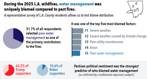 “A recent UCLA-USC study published in ACS Environmental Science and Technology surveyed 1,360 Los Angeles County households in 2025 about views on the role of water management in the Los Angeles fires. The study found that partisan cues were the strongest factor linked to whether respondents blamed water management for the fires’ impacts. The Palisades and Eaton wildfires of January 2025 were the largest wildfires in Los Angeles history and among the most costly in California history. They caused deaths, burned more than 37,000 acres and 16,000 structures, and led to more than $50 billion in direct property damage. The fires also affected the broader region and economy. Eleven county water supply systems were involved in the response in some way. After the fires, public attention to water systems and wildfire response appears to have increased. Water supply is only one part of wildfire response, and it may not always be the highest-priority investment from a cost-benefit standpoint. Still, public and policymaker discussion of water system operations during wildfires has raised new expectations for water agencies. … ” Continue reading at Maven’s Notebook.
Will Rogers and Topanga state parks burned. Now you can help shape their future
“The Palisades Fire burned down historic buildings in Will Rogers and Topanga state parks. California State Parks wants to know what you think about how they should rebuild. Why now? Now that both parks are partially reopened, the agency that oversees them, California State Parks, says it’s ready for the next phase of recovery. Agency authorities say they’re looking to solve big questions, such as how to honor Will Rogers’ legacy and address park needs today. The feedback is expected to help create guiding priorities. The backstory: The Palisades Fire burned more than 8,000 acres between both parks. That included sites beloved by Angelenos, such as Will Rogers’ 31-room ranch house and William Randolph Hearst’s Topanga Ranch Motel. … ” Read more from the LAist.
California solar project threatens Mojave wildlife corridor, scientists say
“The Mojave Desert may look like a flat, brown stretch of nothing between Los Angeles and Las Vegas. But threading through its rocky mountain ranges is an intricate network of wildlife movement that has sustained desert species for thousands of years. Now, scientists and advocates say a solar project approved by the state of California threatens to sever it. In April, the California Energy Commission, the state agency that oversees energy infrastructure, voted 4-0 to approve a $700 million, 1,080-hectare (2,670-acre) solar facility proposed by New Jersey-based developer VC Renewables on federal land adjacent to the Mojave National Preserve. The preserve, spanning more than 1.6 million acres, is one of the largest in the U.S. National Park System and is located in Southern California. The project, known as Soda Mountain Solar, sits in the migration corridor that desert bighorn sheep (Ovis canadensis nelsoni) use to move between mountain ranges. This large solar array would also obstruct desert tortoise (Gopherus agassizii) habitat, which has already undergone significant loss due to climate change and land developments. … ” Read more from Mongabay.
SAN DIEGO
Brown water at Coronado Beach: Algae bloom or Tijuana sewage?
“Patches of brown, green, bubbling water have been washing ashore at Coronado Beach, catching the attention of beachgoers and raising questions about the source. Water samples taken at Dog Beach came back below the threshold for an advisory, according to Coronado Lifeguard Captain Sean Carey, who said he has been in contact with the county’s Department of Environmental Health and Quality. Carey said the county has reassured him the discolored water is the result of harmless algae blooms potentially triggered by higher-than-average water temperatures. However, just a mile and a half south, at Avenida Lunar, an advisory is in effect because bacteria levels are exceeding health standards: Coronado Lifeguard Captain Sean Carey wrote ABC 10News: If you look closely, you will see that the location of the advisory is Avenida Lunar, which is almost 2 miles south of dog beach. We can rule out sewage for a few reasons. … ” Read more from Channel 10.
Along the Colorado River …
Colorado River water managers “wait with bated breath” for federal management plan due this week
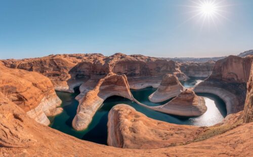
“Max Wilson, like water managers around the Colorado River Basin, spent Monday waiting for a new federal report outlining the river’s future — and future water cuts. He watched the federal website where the report would be published, which appeared to be temporarily down. He sat in the city’s ninth-floor water office, talking about how Phoenix has prepared for this moment, while looking out on the Arizona Capitol and the sprawling metropolis below. “I would certainly say it is tense,” said Wilson, water resources management advisor for the city of Phoenix. “We are waiting with bated breath for the federal government to speak.” Federal agencies are expected this week to release the report, the final version of an environmental review that outlines the government’s plan for how to manage the river basin’s key reservoirs in coming years. It’s one of two reports that represent the culmination of three years of gridlocked negotiations over how to manage the river basin’s key reservoirs after the current management rules expire this fall. … ” Read more from the Colorado Sun.
‘Devastating’ Colorado River cuts could still hit Arizona, official warns
“The federal government is likely to accept the proposal from California, Arizona and Nevada for some cuts to their river water supplies, an Arizona state official said Monday. But the official said he’s also concerned the feds will call for a much bigger cut on top of that — a cut that would slash river water use in those three Lower Colorado River Basin states by nearly twice as much as they’re proposing. Such a cut would be “devastating” in Arizona, he said, speaking on condition his name and title not be used. Not only would the larger potential cut “burn through” the entire supply of the Central Arizona Project that serves drinking water to Tucson and Phoenix, it could cut river water supplies to the agricultural stronghold of Yuma and water now used by riverfront communities such as Lake Havasu City and Bullhead City, he said. … ” Read more from the Arizona Daily Star.
Feds expected to cut Nevada’s share of Colorado River water by more than a quarter
“Nevada will give up more than a quarter of its water allocation under a plan favored by the federal government, according to federal officials. A May 1 proposal from the three Colorado River Lower Basin states — Nevada, Arizona and California — has been accepted as a framework for the next two years. A report from the Los Angeles Times indicates that the three states will reduce their use of the river by 3.2 million acre-feet between now and the end of 2028. That will bring cuts equal to Nevada: 28%, Arizona: 31%, and California: 12%. The cuts aren’t as drastic as feared as recently as May 13, when Arizona officials discussed a federal plan to reduce lower basin use by 3 million acre-feet per year, rather than over two years. That would have brought a 40% cut to Nevada’s allocation. … ” Read more from KLAS.
Water deliveries to Lake Powell could fall more than 50%, researchers warn
“Water deliveries from Colorado’s West Slope river basins to Lake Powell could fall by as much as 52 percent below their baseline median by midcentury, according to a recent study that examined how drought, changing snowmelt patterns and water demand may affect one of the Colorado River Basin’s most important source regions. The study, published July 13 in Earth’s Future, focused on Colorado’s Upper Colorado, Gunnison, Yampa, White, San Juan and Dolores basins, which together provide about 70 percent of Lake Powell’s inflows in a typical year. Lake Powell, behind Glen Canyon Dam on the Utah-Arizona border, is a critical reservoir for Colorado River operations, hydropower generation and water deliveries across the Southwest. … ” Read more from Newsweek.
Razorback sucker, native to the Colorado River, upgraded to “threatened” from “endangered”
“Federal officials after 25 years have upgraded the survival status of the Colorado River native razorback sucker, from “endangered” to the less-serious “threatened,” with state wildlife officials saying the move is proof that multi-agency cooperation can revive environmental icons. Some independent wildlife advocates said the downlisting comes too soon and will renew threats to the razorback sucker, which can grow to up to 3 feet and live four decades. “The razorback sucker’s outlook is no better today than when the fish was originally protected under the Endangered Species Act in 1991, so this move makes no sense,” said Taylor McKinnon, the Center for Biological Diversity’s southwest director. “It’s still in danger of extinction throughout its range.” … ” Read more from the Colorado Sun.
SEE ALSO: Should this Colorado River fish have lost its endangered species status?, from Utah Public Radio
Why we need a new story for the Colorado River
Noa Bruhis with EDF writes, “As the seven Colorado River Basin states struggle to reach consensus on new operating guidelines, I have been participating in an eye-opening Colorado River leadership program, expecting to learn about infrastructure, engineering and water law. Instead, I’ve been surprised by subtler narratives about ownership and extraction that bubbled up several times and struck me as a major barrier to a new plan for managing this critical yet shrinking waterway. The Colorado River Water Leaders Program was created by the Water Education Foundation to foster networking and education in the face of increased water scarcity. It features a tour of the Colorado River, plus regular cohort meetings afterward to continue the dialogue. Our cohort of 12 people includes staff and leaders from state and federal agencies, irrigation districts, the agricultural sector, and two staff members from environmental nonprofits — a colleague from Trout Unlimited and me. … ” Read more from EDF’s On the Waterfront.
Nevada: High-stakes trial underway over Coyote Springs development north of Las Vegas
“A trial that could cost the state more than $1.5 billion is underway in Clark County. The developers of Coyote Springs, envisioned as a bedroom community about 50 miles north of Las Vegas, blame Nevada for killing the project. The State Engineer said water needed for the project wasn’t available. After years of legal wrangling, the developers sued. The trial is expected to last months. Nevada attorneys say water is a public resource, defending the state’s decision. Coyote Springs was developer Harvey Whittemore’s idea. He promoted it as a mini-city with 160,000 homes and 10 golf courses near the border of Lincoln and Clark counties. The golf course that started it all is still in business, but the housing never panned out. … ” Read more from KLAS.
Utah: Concern about data center impacts on Great Salt Lake grows, now for Tooele project’s wastewater
“Like birds that land there in spring and summer, concern about data center development in Utah and how it could affect the drying Great Salt Lake is migrating south. The focus is extending from the lake’s northern tip near the massive proposed Stratos project to its southern shore, near the site where developers are planning a warehouse hub for a data center, along with shipping and manufacturing facilities about 20 miles west of Salt Lake City. Opponents of the plan on Monday raised concerns it could contaminate and further deplete the lake, harming migratory birds and public health as dust containing heavy metals rises from the exposed lakebed. For two hours, they urged state water managers to reject an application from developers to proceed with one part of the bigger Tooele Valley Public Infrastructure District project — a plan to discharge concentrated wastewater brine from a new well. … ” Read more from the Utah News Dispatch.
In national water news today …
How to predict the weather in our era of freakish storms
“On Thursday, June 19, 2025, the National Weather Service in Reno, Nev., issued a two-day forecast for the region that included Lake Tahoe, a popular and mystically blue-green body of water surrounded by mountains, some almost as high as 11,000 feet. Friday, June 20, called for winds of up to 25 miles per hour, punctuated by 40 m.p.h. gusts in the lower altitudes, dangerous conditions for boating and severe enough to prompt a Wind Advisory. But Saturday’s weather — clear, with light winds, the high an unseasonably cool 61 degrees — seemed far more hospitable to recreational activities on the water. On the morning of June 21, anyone looking out a window would have seen blue skies and white sheep-shaped clouds. Anyone reading the morning’s updated weather report would have noted how it validated the earlier one, with slight variations. The forecast called for increased cloudiness and even lower high temperatures, with a slight chance of showers and thunderstorms, the winds strengthening to a still moderate 10 m.p.h. People piled into boats and onto the lake. … ” Read more from the New York Times.
The role of tidal wetlands in the global nitrogen cycle under global change
“It is always encouraging when a new study improves our understanding of a process or compartment within the global nitrogen (N) cycle. This is certainly the case of the recently published study by Langley et al. [2026]. Drawing on an extensive dataset comprising of 8,012 soil N measurements from 255 tidal wetlands, including both salt marshes and mangroves, the authors show that these ecosystems act as important sinks for nitrogen. This stored nitrogen, referred to as blue nitrogen, is buried alongside carbon in wetland soils. The study estimates that tidal wetlands account for approximately 13-15% of marine nitrogen burial, highlighting their role as major hotspots of N accumulation in coastal environments. By retaining nitrogen that would otherwise be transported to adjacent waters, these ecosystems help mitigate harmful environmental impacts such as eutrophication, toxic algal blooms, and water quality degradation. … ” Read more from EOS.

