
Several news sources featured in the Daily Digest may limit the number of articles you can access without a subscription. However, gift articles and open-access links are provided when available. For more open access California water news articles, explore the main page at MavensNotebook.com.
On the calendar today …
- MEETING: Central Valley Flood Protection Board beginning at 9am. Agenda items include Army Corps of Engineers presentation of Levee Inspection Results for Reclamation District (RD) 0501 – Ryer Island levee system; and Presentation of the Natural Resources Management and Planning Division’s Implementation Plans. Click here for the agenda and remote access instructions.
- PUBLIC HEARING: Sites Reservoir Supplemental Hearing beginning at 9am. The State Water Resources Control Board Administrative Hearings Office will conduct a supplemental day of hearing on the pending petition for Assignment of State-filed Application 25517 and accompanying water right Application 25517X01 and the Petitions for Release from priority of State-filed Applications 25513, 25514, 25517 (unassigned portion), 22235, 23780, and 23781 in favor of water right Application 25517X01 of Sites Project Authority. Click here for the notice and procedural ruling.
- WEBINAR: Voyage into the Past: Stories from the California Current: What Happens to Coral Reefs Hit by Disease? from 11am to 11:30am. The USGS studies the roles that coral reefs play for shoreline protection, fisheries benefits, and tourism-based economies. Many Caribbean coral reefs are near collapse due to various threats. An emerging threat, stony coral tissue loss disease (SCTLD), is spreading across the Western Atlantic and Caribbean. Data from the U.S. Virgin Islands reveal how SCTLD spread has reduced the abundance of susceptible coral and crustose coralline algae and increased cyanobacteria, fire coral, and macroalgae. Some reef fishes will decline due to SCTLD, with the largest changes on reefs that lose the most susceptible corals and rugosity. Mapping these projected declines in space indicates how the indirect effects of SCTLD range from undetectable to devastating. The origins of SCTLD and whether it may spread beyond the Caribbean have implications for coral reefs in the U.S. Pacific. Click here to enter the webinar.
In California water news this weekend …
California dodges a bullet on Colorado River cuts
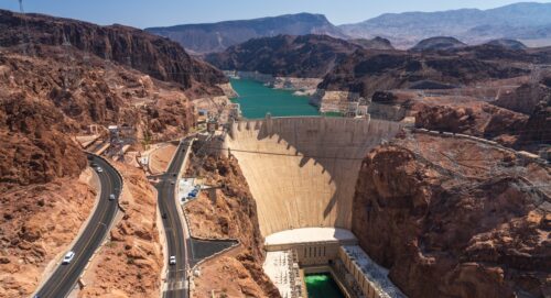 “California and two other states have avoided the harshest water cutbacks the Trump administration could have imposed over the next two years to deal with the deepening crisis on the Colorado River. The Times has learned that federal officials have agreed with an offer made earlier this year by California, Arizona and Nevada to reduce what they take from the river by at least 3.2 million acre-feet between now and the end of 2028. Under the plan, California will cut its use of Colorado River water by about 12% through 2028, Arizona will take about 31% less and Nevada 28% less, according to two officials at state and local agencies who spoke anonymously since details of an announcement are still being finalized. … ” Read more from the LA Times. | Read via Yahoo News.
SEE ALSO:
- Plan To Save Lake Mead Nears as Katie Hobbs Says Water Cuts ‘Unacceptable.‘ from Newsweek
- In Cheyenne, Interior Secretary Says He’ll Act On Colorado River Crisis, If He Has To, from Cowboy State Daily
Groundwater pumping increases subsidence creating major damage
“Corcoran is the proverbial canary in the mine when it comes to the invisible damage droughts are likely to inflect. Between May of 2015 and September 2016 areas near the South San Joaquin Valley community dropped upwards of 25 inches in during that drought due to land sinking with the removal of water from underground aquifers. The subsidence was the end result of jacked up groundwater pumping due to the Bureau of Reclamation cutting off water deliveries as growers scrambled to protect hundreds of millions of dollars invested in cropland and orchards. … When 2017 delivered one of the wettest winters on record for the San Joaquin River water basin to break the back of the last drought, the Friant Water Authority could not use its canals at full capacity to deliver water to farmers. That’s due to subsidence including one segment where the capacity was compromised by 40 percent with most of the loss occurring between 2016 and 2017. Subsidence just doesn’t damage and compromise canals. It also impacts bridges, roads, power lines, and even structures. … ” Read more from the Manteca Bulletin.
New report documents challenges and applications for telemetered water monitoring and a path forward for California
“The California Water Data Consortium and partners recently released a new report with statewide telemetered water monitoring recommendations for the State Water Resources Control Board (SWRCB). The three-part report synthesizes lessons from global telemetry networks, outlines recommendations for a watershed-scale research study, and identifies practical statewide applications for telemetry to support California’s evolving water management needs. Telemetry, the automatic collection and transmission of data through cellular, radio, or satellite communications pathway, has the potential to dramatically improve the speed and accessibility of water data needed for critical decision making. With the State Water Board’s launch of the California Water Accounting, Tracking, and Reporting System (CalWATRS) last year, California is better positioned to receive and use water data in near real time. However, telemetered water monitoring networks can be costly and technically complex to install, operate, and maintain over the long term. As a result, the state needs stronger research and clearer guidance on where telemetry investments are most critical, effective, and cost-efficient. … ” Read more from the Water Data Consortium.
El Niño could become the strongest on record. Hawaii may feel it first
“The Pacific Ocean is exceptionally warm. Years-long marine heat waves, including one along the Southern California coast, are now overlapping with a rapidly intensifying El Niño that could become the strongest on record. With the world’s largest ocean loaded with an extraordinary amount of heat, weather patterns around the globe – including in California – could see major impacts in the fall and winter. Hawaii may not have to wait that long. In past summers preceding a strong El Nino, more tropical storms and hurricanes have tracked close to the islands than in non El Niño years — with August and September a particularly dangerous stretch. Already, a weak spot may be opening in one of the islands’ usual atmospheric defenses against these powerful storms, similar to what has allowed past cyclones to march toward the islands in a strong El Niño year. … ” Read more from the San Francisco Chronicle.
PG&E’s data center pipeline more than doubles in second quarter
“PG&E Corp. reported a 7.6-gigawatt increase in its data center pipeline during the second quarter as the artificial intelligence build-out gains momentum. The California utility’s pipeline of proposed data center projects totaled 12.7 gigawatts at the end of June, up from 5.1 gigawatts in March, the company said Thursday in its latest earnings presentation. The surge underscores that the data-center boom won’t be limited to the states that have dominated AI infrastructure thus far, including Virginia and Texas. The utility separates projects in the pipeline into different categories depending on how far along the interconnection application is. The current makeup of the pipeline shows that while dozens of projects have advanced enough to sign an application and pay a study fee, far fewer are close to getting connected. … ” Read more from the San Jose Mercury News.
California can’t replant its forests fast enough to keep up with wildfires
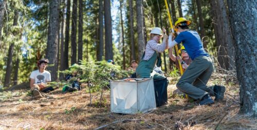
“A windowless warehouse on the outskirts of Davis shelters pieces of California’s forests. Icy air swirls and fogs around 42,000 pounds of seeds — the past and the future of these trees, frozen in cardboard boxes. It smells like the woods on a snowy day. “This is like the mothership of forestry in California right here,” said Stewart McMorrow, staff chief for wildfire resilience at Cal Fire, standing outside the heavy metal door of the state seed bank at Cal Fire’s Lewis A. Moran Reforestation Center in Davis. Private landowners especially rely on these seeds — some now more than a half-century old — to reforest property destroyed by wildfire. At the pace California is burning, it’s nowhere near enough. Climate change and more than a century of overzealous fire suppression are now fueling wildfires so severe that they’re wiping out the very forests that need fire to thrive — leaving iconic landscapes at risk of turning into brush and scrub, permanently. Over the past quarter century, high-severity wildfires have burned 2.3 million acres of California’s forestland so completely that the trees are unlikely to return on their own — according to a working draft of the state’s new reforestation strategy obtained by CalMatters. … ” Read more from Cal Matters.
Controlled burns have saved thousands of giant sequoias
“The use of small, controlled burns to clear out flammable underbrush has saved thousands of giant sequoias from devastating wildfires, new research finds. The largest trees on Earth, sequoias can reach more than 300 feet tall and live for 3,000 years, but they grow only in a narrow band of the Sierra Nevada mountains in California, where hotter, drier weather has left forests increasingly prone to wildfires. With their thick bark and high canopies, the trees can withstand small fires, but the more intense blazes seen in a warmer climate have proved deadly for thousands of trees. Together, the 2020 Castle Fire and 2021 KNP Complex Fire killed as many as 13,000 giant sequoias, or close to a fifth of all sequoias. According to the new study, the death count would have been considerably higher without the use of prescribed burns. … ” Read more from Yale e360.
Why only a few wildfires become extreme
“Hot and dry conditions have become synonymous with the risk of extreme wildfires. But a new paper argues that such conditions are not by themselves sufficient for blazes, and most warm years do not result in the burning of exceptionally large areas. The reason is that extreme fires — the few percent of fires that grow rapidly, keep spreading, and end up accounting for nearly all of the area burned — need brief-lived windows of opportunity: an unusual confluence in which winds, terrain, dry vegetation, and ignition coincide. Warm, dry conditions can prime broad regions for burning, but only certain weather setups allow a fire to grow rapidly and keep spreading. These conditions vary from one region to another and may last only a few days. Understanding such windows of opportunity is critical, according to the paper. Wildfire activity is dominated by rare events. Only a small fraction of fires grow large, and yet that small fraction accounts for nearly all of the area burned. … ” Read more from NCAR.
Steve Hilton says California must end California’s “war on agriculture”
“California’s agricultural industry has long been recognized as one of the world’s most productive food-producing regions, but according to California gubernatorial candidate Steve Hilton, state government has spent years making it increasingly difficult for farmers and ranchers to succeed. During an extensive interview with Nick Papagni, “The Ag Meter,” Hilton laid out his vision for California agriculture, discussed his campaign for governor, and shared why he believes restoring support for farming should be one of Sacramento’s highest priorities. Throughout the conversation, Hilton also addressed affordability, water policy, energy, infrastructure, government spending, and what he believes must change if California hopes to remain competitive. … ” Read more from AgNet West.
In commentary this weekend …
The valley water built
Geoffrey Vanden Heuvel, Director of Regulatory and Economic Affairs at Milk Producers Council and Vice Chair of the Water Blueprint for the San Joaquin Valley board, writes, “To most Californians, the San Joaquin Valley is farmland and freeway: the flat stretch of Interstate 5 or Highway 99 between the Bay Area and Los Angeles, crossed on the way to somewhere else. But the farmland and the food it produces are only what the Valley is famous for. It is not the whole of what the Valley is. Those drivers are passing one of the youngest and fastest-growing regions in California, home to more than four million residents, a population larger than half the states in the union, with an under-35 majority that is the workforce California is counting on for the next fifty years. And that workforce is being educated here, at scale, by institutions the drive-through story never mentions. California’s first chartered university has called Stockton home for a century. Fresno State currently ranks fourth in the nation for moving students up the economic ladder, and it shares the Valley with Stanislaus State and CSU Bakersfield in a university system that leads the country in social mobility. A UC campus in Merced, opened in 2005, reached the top tier of American research universities in under twenty years. A network of community colleges is strung along the entire length of Highway 99, putting higher education within a short drive of nearly every Valley family. … ” Read more from the Water Blueprint for the San Joaquin Valley.
California’s data center backlash is loud—and deeply misplaced
Opinion writer Tom Philp writes, “More than 100 recent protests across California and the U.S. over data centers represent the same fierce opposition that horse enthusiasts once mounted against Model T cars. The times eventually change. And so, in the end, do we. Today, talk of a new data center brings home how artificial intelligence is wrongly changing our future. The physical embodiments of this rapid evolution are the buildings with the humming servers that are increasingly tapping precious supplies of electricity and water. We are worried about the wrong thing. California in particular is much more likely to successfully manage the resource demands of artificial intelligence than the technology itself. Trying to stop the demand for any given new data center is as meaningful as trying to thwart a meteor with a squirt gun. … ” Read more from the Sacramento Bee.
In people news this weekend …
Promotions, passings, profiles – submit people news items to maven@mavensnotebook.com.
Kern County Water Agency names Taryn Ravazzini Assistant General Manager – Strategic Initiatives
“The Kern County Water Agency (Agency) today announced that Taryn Ravazzini has been named Assistant General Manager – Strategic Initiatives, effective August 16, 2026. Ravazzini will join the Agency’s Executive Management Team to lead the Agency’s strategic, regulatory, and legislative initiatives before the State Water Resources Control Board, the California Department of Water Resources, the California Legislature, and fellow State Water Project contractors. Ravazzini’s new role, based in the Agency’s Sacramento office and reporting directly to General Manager Eric L. Averett, reflects the Agency’s continued focus on advancing its interests in statewide water policy, regulatory proceedings, and long-term water supply planning. … “Taryn has led some of the most consequential water policy and infrastructure programs in the state by building trust across agencies and stakeholders with very diverse interests,” said Eric L. Averett, General Manager of the Kern County Water Agency. “Her experience will strengthen our ability to protect and advance the Agency’s water supply and regulatory interests at the state level.” … ” Read more from the Kern County Water Agency.
Podcasts …
RIPPLE EFFECT: Colorado River minimum elevation drawdown
We talk all about the recently published report titled: “Why Communicating Minimum Drawdown Elevations from Lake Powell and Lake Mead can Mitigate Risks of Volatile Colorado River Flow”. Joining us are the three co-authors and star guests from Utah State University: David Rosenberg, professor in the Department of Civil and Environmental Engineering, Brittany Fager, PHD student and Student Researcher, and Anabelle Myers, Student Researcher. With historically low reservoir levels and inflows, this report seeks to prevent the catastrophic consequences of too low water levels, and seeks to determine at exactly what point those consequences happen. Armed with this knowledge, we can make smarter water decisions.
WATER IS A MANY SPLENDOR’ED THING: Building a Dam Isn’t Easy
 Near the border of Nevada and Arizona is a monolithic icon that controls the Colorado River and attracts a world audience each and every year. The Colorado River’s historic behavior was intermittent, very turbulent flows followed by low river flow periods. Building Hoover Dam was an extraordinary feat. Water is a Many Splendor ’ed Thing brings you another water relationship that has a personally significant impact to your life. Produced by Stephen Baker, Bringing People Together to Solve Water Problems, water@operationunite.co 530-205-6388
VIC BEDOIAN: Feds Fail to Protect Endngered White Sturgeon
White Sturgeon are the largest freshwater fish in North America and an ancient species that once thrived in the San Francisco Bay estuary. Now they’re in decline. Federal officials announced Tuesday that although the White Sturgeon meets the criteria for endangered status, the government will not take any action to save it. The endangered species finding was compelled by a lawsuit filed in 2023 by San Francisco Baykeeper and other environmental advocates. Vic Bedoian reports from Fresno. Photo courtesy of Fiorella Ikeue in collaboration with SF Baykeeper.
ECONEWS: Trump attacks the California Coast
The Trump Administration is going after California’s coast. To curb California’s power to stop harmful development off of its coast, NOAA has announced a new review of the California Coastal Management Program. The program is California’s way of implementing the Coastal Zone Management Act and allows more power for California to review and check federal projects off our coast. While NOAA conducts routine, periodic performance reviews of state coastal programs, it appears that this is deliberately to strip power from the state in order to advance more oil and gas developments and “space port” developments desired by Trump acolytes like Elon Musk.
WATERLOOP: AI as the water operator’s copilot
Water utilities are rich in data but often struggle to turn decades of information into decisions that improve daily operations. In this episode, Travis Wagner of Trinnex explains how utilities can connect fragmented information, preserve workforce knowledge, and introduce artificial intelligence without sacrificing accuracy or security.
In regional water news this weekend …
NORTH COAST
New native plant network seeks to grow regional capacity
“This June, the Eel River Native Plant Network held its first in-person meeting in Fortuna with about 45 people in attendance. The Native Plant Network seeks to connect Tribal Nations, stewards, gatherers, and growers to sustain and increase diverse native plant material production that supports Eel River ecosystem restoration, cultural uses, and food sovereignty. Network members include representatives of Tribal Nations, commercial nurseries, NGOs, private property owners, and regional, state, and federal agencies. Nearly 50 different entities have engaged with the Network. “This Network is all about collaboration, working together to strengthen grant proposals, sharing infrastructure and knowledge, and increasing production of locally native plants,” said Christina Cortez, Native Plant Materials Project Coordinator with the Mattole Restoration Council. … ” Read more from My Humboldt Life.
SIERRA NEVADA
FEMA updates flood maps in Plumas County
The Federal Emergency Management Agency (FEMA) has delivered revised preliminary flood maps for the Unincorporated Areas of Plumas County, California. The maps identify revised flood hazards along more than 15 streams and channels throughout Plumas County. The new maps will help building officials, contractors, and homeowners make effective mitigation decisions, thereby contributing to safer and more disaster-resilient communities. Before the new Flood Insurance Rate Maps (FIRMs) become effective, there is a 90-day appeal period from August 7, 2026 to November 4, 2026. During that time, residents or businesses with supporting technical and scientific information, such as detailed hydraulic or hydrologic data, can appeal the flood risk information on the revised preliminary maps, which can be viewed at hazards.fema.gov/femaportal/prelimdownload/. … ” Read more from the Sierra Booster.
Granite to replace spillway at PG&E dam after post-Oroville safety review
“Granite Construction announced July 22 that it has received a $50-million contract from Pacific Gas & Electric (PG&E) to replace the spillway at Northern California’s Tiger Creek Regulator Dam, where construction began in May. The work follows spillway assessments PG&E conducted after the 2017 Oroville Dam spillway failure prompted federal and California dam-safety regulators to require hydroelectric operators to reevaluate aging spillways using updated hydrologic modeling and engineering analyses. At Tiger Creek, the review identified deterioration in the existing spillway chute, uncertainty over whether the dam’s three spillway siphons would activate as intended and inadequate hydraulic capacity under probable maximum flood conditions. … ” Read more from the Engineering News-Record.
California conservation leaders discuss Lake Tahoe’s future
“Collaboration across state lines, restoration of wetlands and meadows, and partnerships with the Washoe Tribe are among the most important strategies for protecting Lake Tahoe as it faces growing pressures from climate change, invasive species and increasing visitation, conservation leaders said Wednesday during a California Natural Resources Agency panel. The discussion, titled “Conserving California’s Iconic Waters: The Future of Lake Tahoe, the Salton Sea, and Clear Lake,” featured leaders from organizations working to restore and protect the state’s largest lakes. During the Lake Tahoe portion of the panel, representatives from the California Tahoe Conservancy and the League to Save Lake Tahoe discussed how decades of regional cooperation have shaped restoration efforts and what challenges lie ahead. Jason Vasques, executive director of the California Tahoe Conservancy, said Lake Tahoe’s geography makes protecting the basin uniquely complex. “Lake Tahoe sits on the California-Nevada border, spans four counties and is the homeland of the Washoe Tribe,” Vasques said. “We have to manage it collaboratively.” … ” Read more from the Sierra Sun.
Forest Service explains glyphosate caution sign after online speculation
“A photo circulating on social media showing a caution sign referencing glyphosate has prompted confusion among Lake Tahoe residents over whether herbicides are being applied in the basin. The image, shared in a Facebook post on July 9, shows a yellow caution sign with the word “glyphosate” and the date “06/25/26” handwritten in black marker. The photo was allegedly taken near Tallac Point. Comments on the post said the sign had been replaced with a ribbon labeled “Invasive Species.” The controversy surrounding glyphosate has grown in recent months following a Mother Jones investigation examining the herbicide’s potential carcinogenic risks, major lawsuit settlements and ongoing debate over the extent of scientific research on its health effects. … ” Read more from the Tahoe Daily Tribune.
Tahoe clarity holds steady according to State of the Lake Report
“The University of California, Davis, Tahoe Environmental Research Center (TERC) released its “Tahoe: State of the Lake Report 2026”, which presents data from 2025 in the context of the long-term record. The report provides an annual update for non-scientists on the Lake Tahoe Basin’s ecological health. It includes data related to temperature, precipitation and snowmelt, nutrients, algae, water clarity and more. To learn more about the state of Lake Tahoe and ongoing research and educational outreach efforts, read the full report. … ” Read more from the Tahoe Guide.
BAY AREA
Pacific hurricane to send powerful waves to Bay Area beaches this weekend
“Hurricane Fausto will send powerful waves toward the California coast this weekend, creating dangerous surf conditions at Bay Area beaches even while the storm remains far out in the eastern Pacific. The National Weather Service issued a beach hazards statement that will last from Saturday morning through Tuesday afternoon for Pacific beaches from Sonoma County through the Big Sur coast. The long-period swell will increase the risk of sneaker waves and strong rip currents, with breaking waves reaching up to 10 feet at some south- and southwest-facing beaches and prominent surf breaks. “Dangerous conditions are forecast along the shoreline,” the weather service said. “Hazards include sneaker waves, strong rip currents, and large breaking waves.” … ” Read more from the San Francisco Chronicle.
SEE ALSO: First eastern Pacific hurricane of 2026 sends giant swells to California, from SF Gate
Column: Where do we go from here with California Forever?
Columnist Danette Mitchell writes, “While each Solano County city has its own unique priorities and challenges, some residents express key concerns, including the need for affordable housing and the availability of higher-paying local jobs, as discussed in the NorthBay 2025 Community Health Needs Assessment report. The report also highlighted that rising rent and mortgage costs, coupled with high construction expenditures, have worsened the housing crisis, especially in the Fairfield area. Residents must commute out of the county for employment that matches their skills and offers a living wage. Others must take on two or even three jobs to make ends meet. Lack of economic opportunities, the report continues, often leads to an unequal distribution of financial and economic resources, particularly affecting populations such as Black American residents and youth of color. … ” Read more from the Vacaville Reporter.
Going down the drain: Inside the process of wastewater treatment
“Where one person’s business ends, another’s begins. This is the case for the wastewater produced at the flushing of a toilet or the running of sinks and showers. Routed from Pleasanton, Dublin and southwest San Ramon, the wastewater travels through hundreds of miles of underground pipes to the Regional Wastewater Treatment Facility in Pleasanton. It is here that Dublin San Ramon Services District treated an average of 12.05 million gallons a wastewater daily last year to either become recycled water or for release to the San Francisco Bay. Founded in 1953, the not-for profit public utility supports over 194,600 people with its services, which includes wastewater collection for its customers in Dublin and southwest San Ramon as well as recycled and potable water service to Dublin and Dougherty Valley. DSRSD also treats sewage from Pleasanton under a longstanding contract with the city, which owns, operates and maintains the sewer collection system within its boundaries. … ” Read more from Pleasanton Weekly.
East Palo Alto plans construction of 3-million-gallon water storage tank
“The East Palo Alto City Council weighed location options on Tuesday for its first ever potable water tank – a 3-million-gallon storage structure that has the potential to improve local water pressure and change the appearance of a neighborhood. State water agencies and the city’s water system master plan have long called for at least 5 million gallons of water storage in East Palo Alto. Currently, the city’s water supply comes from the San Francisco Public Utilities Commission and it flows through a single “pressure zone” at the northern part of East Palo Alto. City officials say increased water storage throughout the city would improve water pressure at peak-use times and boost fire hydrant efficiency. City staff and Sand Hill Properties are currently planning to construct a 1.5-million-gallon water tank as part of a Woodland Park Improvement project, but the city still has more work to do. … ” Read more from Palo Alto Online.
CENTRAL COAST
The tricky art of growing oysters in the lab so they can survive in the field
Katie Rodriguez writes, “On July 1, a foggy morning, Moss Landing Marine Lab researchers along with the Amah Mutsun Tribal Band, Amah Mutsun Land Trust and The Nature Conservancy, prepare to plant baby oysters in Elkhorn Slough’s Oak Marsh near Santa Cruz. This “outplanting” session is one of many that have happened over the years as part of a restoration project started in 2018. The goal is to eventually plant 10 million oysters, a whole hectare, in the Slough. As a photojournalist I’m tagging along to document this ambitious effort for KneeDeep. Conception begins at the Moss Landing Marine Labs aquaculture facility in Monterey County, where Olympia oysters broodstock are spawned. Eventually, millions of these oysters will be outplanted in the Elkhorn Slough, a winding estuary that extends inland from Monterey Bay. … ” Read more from Knee Deep Times.
Aqua Cruz board game offers hands-on learning about Santa Cruz water supply
“This summer, Santa Cruz residents will have an opportunity to learn about the city’s water supply, not through public meetings or policy documents, but by playing a board game. The Santa Cruz Water Department and Water Commission have developed a hands-on way to understand the department’s work. The game, called Aqua Cruz, has a mix of familiar elements inspired by games such as Monopoly, Chutes and Ladders and even Settlers of Catan. With help from Miller Maxfield Inc. and local printers, the department has created seven copies of the board game, which anyone can play for free at a series of events over the summer. The next gameplay session will take place Saturday at the Downtown Santa Cruz Library. … ” Read more from the Santa Cruz Sentinel.
Monterey County officials remain flexible as an El Niño event is underway.
“Every two to seven years, El Niño generates buzz among scientists, government officials and communities wondering what impacts it could have across California. With another El Niño event underway, Brian Garcia, a meteorologist at the National Weather Service’s Monterey office, says it’s important to understand what the climate pattern is, and what it isn’t. “El Niño is not weather,” Garcia says. “It is an anomalous area of warm sea-surface temperature water across the equatorial Pacific. It can have an outsized influence on how weather acts around the world, but it doesn’t make the weather itself.” El Niño “tilts the odds” toward wetter winters, he says, but doesn’t guarantee an extreme winter everywhere. On July 9, NOAA’s Climate Prediction Center said there was an 81-percent chance of a “very strong” El Niño from October through December, and expected to persist into early spring. … ” Read more from Monterey Now.
Water rates could spike in a SLO County beach town — but there’s another option
“Los Osos residents might see an increase in their water bill in two years — but the bill could also hold steady. It all depends on the California Public Utilities Commission. This month, Golden State Water Company applied to the California Public Utilities Commission for new water rates for 2028 through 2030. The water company also applied to consolidate its Santa Maria Service Area with the Los Osos Service Area, which would prevent a rate increase for Los Osos, Golden State Water’s Coastal District general manager Mark Zimmer said. “What Golden State ultimately wants to do is keep the rates as low as possible, but without compromising the public health and safety of the community,” he said. “So there’s a balance there.” … ” Read more from the San Luis Obispo Tribune via Yahoo News.
SAN JOAQUIN VALLEY
Newest state park outside Modesto is restored floodplain
“Looking for a low-key place to explore the San Joaquin Valley in its natural state complete with hiking trails — most that are suitable for mountain bikes — as well as picnic areas? The Dos Rios State Park is roughly eight miles west of Modesto and covers some 1,600 acres; it opened to the public just over two years ago, in June of 2024. It was once private farmland that has been restored to its natural state at the confluence of the Tuolumne and San Joaquin rivers. It allows visitors to step back in time as they meander through a restored floodplain forest to explore the reconnection of water, wildlife, conservation and ranch life. Dos Rios is home to various threatened and endangered species, including the valley elderberry longhorn beetle and the riparian brush rabbit. … ” Read more from the Oakdale Leader.
As Kings and Tulare fairgrounds consider leasing land for data centers, communities balk
“Residents in Tulare and Kings counties have concerns about the possibility of small data centers coming to the fairgrounds in both counties sometime in the future. The Tulare and Kings counties fairgrounds are evaluating a proposed partnership with Global Stack LLC to help strengthen the fairgrounds long-term financial sustainability as year-round public venues. The California-based company plans to build a network of edge computing systems at fairgrounds throughout the state. It is unclear how much money the partnership would bring to each of the fairgrounds annually. Details of the proposal, including the location of the project on the fairgrounds or timeline, have not been disclosed by either party. … ” Read more from the Sacramento Bee.
Deadline to file for host of Kern County water board seats is Aug. 7
“There are a host of Kern County water board seats up for election this November. The deadline to throw you hat in the ring is August 7. Races for water board seats don’t typically attract the kind of attention that hot congressional or even city council seats do, but they should. Water boards are in charge of making sure your water is drinkable; they decide how much you pay for it; and make rules about whether you can run your sprinklers on Mondays or Tuesdays and for how long. Some local boards are in charge of regional and statewide issues that can impact our economy in very real ways. … ” Read more from SJV Water.
SOUTHERN CALIFORNIA
Sunset Boulevard set to reopen Friday despite discovery of ‘pinhole’ leak after water main repair
“The Los Angeles Department of Water and Power insisted Thursday it is on track to reopen a stretch of Sunset Boulevard in West Hollywood that was damaged by a major water main break by the end of the week, despite finding a new “pinhole” leak that caused water to bubble up in the sinkhole the agency had just finished backfilling. After making what the DWP called “steady progress” on repairing of the ruptured 36-inch diameter pipeline, crews around 8:30 p.m. Wednesday observed water coming up from the area being backfilled and prepared for paving. “Currently, there are no known impacts to our goal of reopening the street Friday,” DWP said in an announcement Thursday morning. “LADWP crews continued repaving and striping of Sunset Boulevard early this morning while working to repair a small pinhole sized leak identified last night at the east end of the worksite. … ” Read more from the LA Daily News.
IMPERIAL/COACHELLA VALLEYS
Data center developer sues for right to use Colorado River water in thirsty California county
“The developer behind a proposed $10 billion data center has filed a lawsuit asserting his rights to Colorado River water in California’s Imperial Valley. Sebastian Rucci is a Huntington Beach lawyer and businessman pushing the plan in a region already known as a big water user. The Imperial Valley sprouted as an agricultural center that’s the largest user of Colorado River water in the seven states that rely on the river. Farmers use about 80% of the state’s full allocation. As managing member of Imperial Valley Computer Manufacturing, Rucci filed his lawsuit June 5 in California Superior Court in Imperial County. After two cities — El Centro and Imperial — snubbed Rucci’s bid to get recycled wastewater to cool the proposed data center, the developer went back on a statement that he had no intention of using water from the over-allocated Colorado River. … ” Read more from KLAS.
Along the Colorado River …
Mexico and US team-up to build desalination plant in Baja

“Mexico says it’s finally going to hire a company to build a plant that turns the ocean into freshwater in Rosarito, reviving an idea shelved years ago amid protests that the government was privatizing water. And, in the name of reducing how much water Mexico takes from the Colorado River, the United States is going to help get the water to the cities that need it. Construction could start as soon as Aug. 1, according to a federal Mexican project website, but the government had not yet selected a builder. Mexican President Claudia Sheinbaum’s administration announced plans to restart the building of the desalination plant in May 2025. But multiple attempts by the Sheinbaum administration to secure a private builder have failed. In March, the North American Development Bank – a special bank created by the United States and Mexico to pool equal shares of investment for infrastructure projects – announced it would lend Mexico up to $114 million to build and reinforce the pipes and pumps the plant needs to get water to rapidly-growing urban cities in Baja California. Treated ocean water, the bank says, would replace some of the Colorado River water Mexico is entitled to under a treaty with the United States. … ” Read more from the Voice of San Diego.
DRI and OpenET are partnering with the Upper Colorado River Commission and the Bureau of Reclamation to expand evaporation monitoring on the Colorado River
“DRI and OpenET are partnering with the Upper Colorado River Commission and the Bureau of Reclamation to expand evaporation monitoring on the Upper Colorado River Basin’s largest reservoirs. This summer, new monitoring stations are being established on Flaming Gorge, Blue Mesa, and Navajo Reservoirs. The initiative follows the success of the Lake Powell evaporation monitoring project – one of the longest-running reservoir evaporation monitoring efforts in the Western U.S., which has provided data since 2019. Establishing state of the art weather and evaporation monitoring stations at these reservoirs will directly inform improvements for evaporation models and our understanding of water availability in the Colorado River. … ” Read more from the Desert Research Institute.
APS to convert Cholla power plant from coal to natural gas. It expects water usage to be the same
“Earlier this month, APS announced that it plans to convert its Cholla coal plant to natural gas by 2029. While APS says it will reduce emissions, the utility expects water use to be about the same. Natural gas plants are often touted for using less water than their coal counterparts. A report from the U.S. Energy Information Administration found that, on average, natural gas water usage was about seven times lower than coal. … ” Read more from KJZZ.
Salt Lake City wants to limit nonresidential water use to 200,000 gallons daily
“Utah’s capital city approved an emergency measure earlier this year to crack down on the amount of water new nonresidential developments use daily. The measure complicated the federal government’s desire to build an immigrant detention center on the city’s west side at the time, but the city could strengthen those restrictions as its leaders look to permanently include the measure in code. Salt Lake City is considering a new ordinance that would limit new nonresidential properties to 200,000 gallons per day, mirroring the emergency order issued in March. Uses tied to agriculture would be exempt, as would water consumed by schools, government-owned or operated facilities that primarily provide social services, places of worship and hospitals. … ” Read more from KSL.
Colorado basins supplying 70% of Lake Powell’s water face major midcentury shortages
“If the Colorado River Basin is the lifeblood of the American Southwest, keeping the region’s agricultural, ecological and economic systems thriving, Colorado’s West Slope River basins could be considered the heart. Together, they contribute about 70% of the water delivered to Lake Powell, the second-largest reservoir in the nation. A new Cornell study, the most extensive of its kind, shows how drivers of water shortages, from melting snowpack to growing population demands, may affect this collective of six basins and Lake Powell—a major source of energy and water supply for 40 million people that has been in the grip of severe drought for the past 20 years. One of the region’s most significant challenges, the study finds, is a potential 50% drop in the West Slope basins’ inflows to Lake Powell over the next several decades. The findings are published in Earth’s Future. The lead author is postdoctoral researcher Sai Veena Sunkara. … ” Read more from PhysOrg.
Nearly 460 miles of rivers in Colorado under fishing restrictions as a result of heat and drought
“The small town of South Fork, Colorado, is named for a tributary of the Rio Grande River, which joins with the main river in the middle of town. This stretch of the Rio Grande is labeled a “Gold Medal” fishery by the state, meaning flyfishers have a better chance of catching more and bigger trout. It’s typically a prime destination for late afternoon casting right in sight of the nearby golf course. Not this summer. The Rio Grande River running through the town of South Fork is about 87% lower than normal for this time of year. Those trickling flows and well above normal water temperatures have led Colorado Parks and Wildlife to place a voluntary fishing closure on 74 miles of the Rio Grande from noon until midnight. … ” Read more from Colorado Public Radio.
Colorado’s largest wildfires this summer could cost a quarter billion dollars, early estimates show
“The costs of Colorado’s summer wildfires are racking up. It could cost taxpayers about $266 million to cover the response, suppression and recovery for the state’s four largest fires this summer according to a developing 90-day cost projection, state officials said during Thursday’s Drought Task Force meeting. “The financial impacts on things that cascade from drought impacts and so forth are tremendous,” Chris Sorensen with the state emergency operations center told the task force. “In light of cutting $2.5 billion out of the state’s budget over the past 15 or 18 months, that’s a very notable number.” The costs extend beyond finances to lives lost, homes destroyed and communities disrupted, Sorensen said. Four Colorado wildfire responders died fighting the fires. Hundreds of Coloradans lost homes. “The impacts are widespread, and all interrelated,” he said. “We’ve heard so many things, but let’s keep in mind all of those impacts, including the lives that are lost.” … ” Read more from the Colorado Sun.
In national water news this weekend …
Water is one of four fronts in Interior’s AI push
“On Wednesday, July 22, the U.S. Department of the Interior described the part it plays in what the federal government calls the Genesis Mission. The Genesis Mission is a government-wide effort led by the White House Office of Science and Technology Policy. According to the Interior Department, it uses artificial intelligence to speed up scientific discovery, strengthen American energy production and support national security. Artificial intelligence, in this setting, is not a chatbot. It is software trained on enormous piles of measurements so it can spot patterns and make predictions faster than people can. That software needs raw material. Interior says it holds a great deal of it. … ” Read more from Western Water.
Interior releases major update on coal potential beneath federal lands
“The Department of the Interior today released a U.S. Geological Survey report on coal resources beneath federally managed public lands in the United States, estimating that there are 4.2 billion short tons of reported coal reserves associated with active mines and an additional 356 billion short tons of available coal resources. If produced, that would be enough coal to supply all the nation’s needs for at least 600 years at the current rate of consumption. “American Energy Dominance is more important than ever, and so is beautiful clean coal’s role in the production of electricity needed to fuel our future prosperity,” said Secretary of the Interior Doug Burgum. “Thanks to the USGS’s rigorous and independent assessment, we’re better equipped to manage America’s vast public lands responsibly while supporting energy security and economic opportunity.” … ” Read more from the Department of the Interior.

