
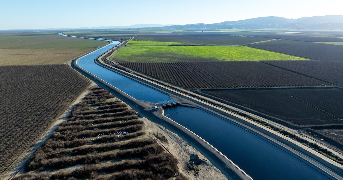
Groundwater-driven land sinking in the San Joaquin Valley is reducing aqueduct capacity, prompting interim repairs and long-term planning.
At Metropolitan Water District’s May Imported Water Subcommittee meeting, Christopher Martin, executive policy advisor for the State Water Project at the California Department of Water Resources, outlined the extent of subsidence along the California Aqueduct, the state’s response strategy, planned corrective measures, and the funding now being assembled for repairs.
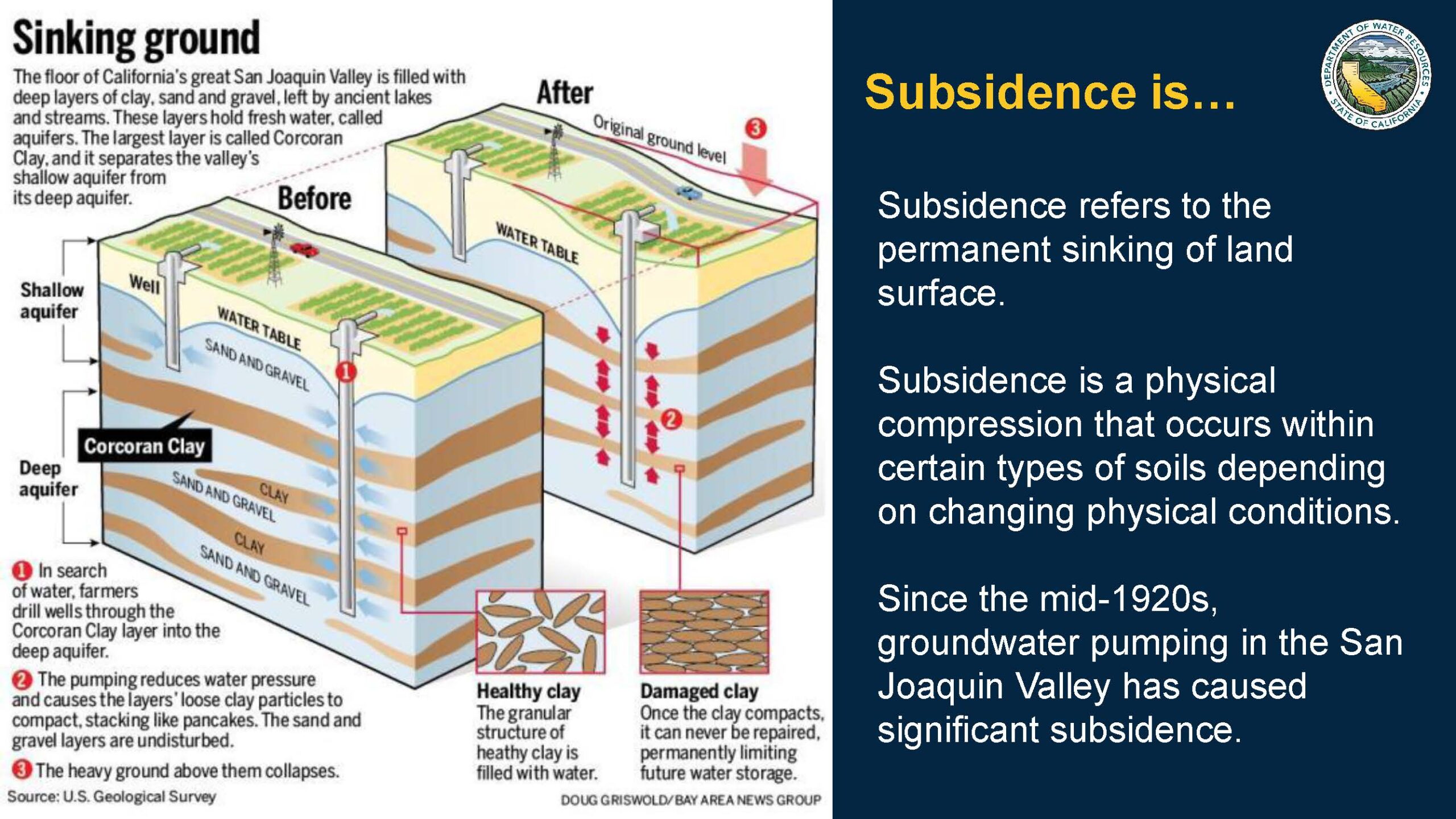 Subsidence occurs when groundwater pumping lowers water levels and reduces pore pressure in the aquifer system, causing the fine-grained clay and silt layers in the sediments to compact. In the San Joaquin Valley, those compressible clay-rich layers are especially important: they act like weak, water-bearing cushions between coarser sand and gravel aquifers. When pumping draws down groundwater, the clays slowly drain and compress, and much of that compaction can be permanent. As those buried layers thin, the land surface above sinks. Because the sinking is often uneven from place to place, it creates differential subsidence that can distort the slope and freeboard of infrastructure such as the California Aqueduct, reducing conveyance capacity and increasing repair needs.
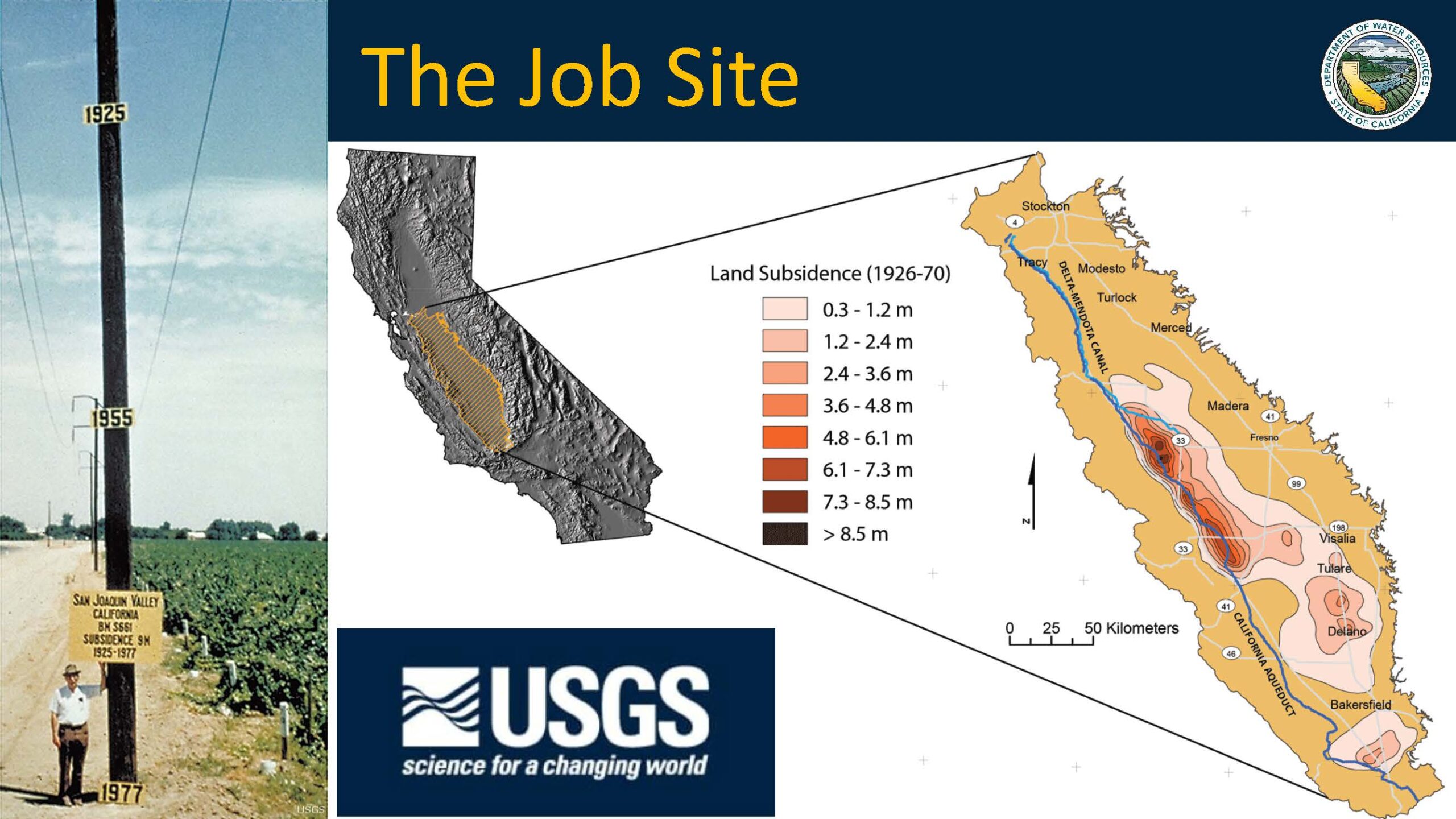
Subsidence in the Central Valley has been documented since at least the 1920s, driven largely by long-term groundwater pumping in one of the world’s most intensively farmed regions. By the time construction of the State Water Project was completed around 1970, parts of the San Joaquin Valley had sunk by more than 8.5 meters, or nearly 30 feet.
The California Aqueduct was built with subsidence in mind. Its design included extra freeboard, the vertical distance between the water surface and the top of the channel lining, to help preserve operating capacity as land levels changed. Operating criteria called for at least three feet of freeboard, and many reaches had more than that when construction was completed.
“We expected over time that subsidence would continue,” said Mr. Martin. “The assumption was it would continue and tail off as surface supplies from the State Water Project began to supplement or displace groundwater supplies in the San Joaquin Valley.”
The map traces the California Aqueduct through the San Joaquin Valley and highlights the main subsidence zones. Darker areas mark subsidence bowls where land levels have fallen by roughly 11 to 12 feet since the aqueduct was built, reducing much of the extra freeboard incorporated into the original design.
The approximately 100-mile reach of the California Aqueduct from O’Neill Forebay near Los Banos to Kettleman City is known as the San Luis Canal. The segment is part of the state-federal joint-use facilities that deliver water for both the State Water Project and the federal Central Valley Project, so repair costs on this reach are shared by the state and federal governments.
DWR’s strategy for addressing subsidence
By about 2006, early signs showed subsidence was beginning to affect aqueduct operations. Since then, DWR’s response has developed into a multipronged strategy focused on assessment, operations, corrective action, funding, and prevention.
- Characterize the problem.
- Modify operations. DWR adjusted aqueduct operations under a rule allowing a minimum of one foot of freeboard and adopted special conditions that keep water levels higher than they otherwise would be so turnouts can continue to operate along the aqueduct.
- Implement corrective actions.
- Pursue cost-effective interim actions to reduce the effects of past subsidence on deliveries and improve flexibility before long-term solutions are in place.
- Advance long-term actions to address both past and projected subsidence and restore operational flexibility.
- Pursue public investment. DWR has worked with the State Water Project and Central Valley Project to seek public funding for repairs.
- Advocate for preventive action by working with groundwater sustainability agencies and reviewing groundwater sustainability plans, an option that became available only after implementation of SGMA.
The work began with reports published in 2017 and 2019 that compiled available data and research to better define the problem. The studies focused on a 10-mile-wide corridor along the aqueduct to identify not only the causes of subsidence, but also where the most significant operational impacts were occurring.
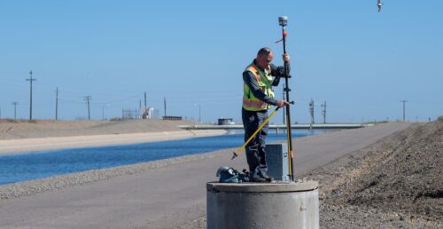
DWR later developed planning and decision-making tools, including a hydraulic model that estimates how much water the aqueduct can convey at steady flow under different capacity conditions. A second tool, a probabilistic subsidence model, evaluates a range of future subsidence scenarios. Martin said that model is largely based on the historical relationship between surface-water deliveries and subsidence before SGMA, a relationship that may change over time.
When DWR prepared its 2017 and 2019 reports and the forecasting tools now in use, the agency was working in a period of significant uncertainty. Climate change remains one source of that uncertainty, and SGMA is another.
“We didn’t have groundwater sustainability plans until 2020 and what nobody had, even in 2020 was good firsthand data about the degree of success implementing those plans, so really a tremendous amount of uncertainty as we started this process,” said Mr. Martin. “As a result, there’s a wide range of possible futures when we run all the models.”
The forecasts rely on a set of assumptions intended to provide a planning benchmark rather than a prediction of the most likely outcome. Among those assumptions are that no corrective actions are taken to address subsidence and that the aqueduct continues operating under restricted freeboard and other special conditions.
An addendum to the 2023 Delivery Capability Report, released in 2025, framed the issue as increasingly urgent.
“The forecast in the DCR addendum shows us, if we take into account the combined effects of climate change and take no physical action, we could be looking at anywhere from an 18% delivery reduction by 2043 all the way up to an 87% delivery reduction by 2043,” he said. “Just to emphasize, those projections are for a no action alternative. They’re useful as a benchmark, but we’re already moving away from that no action future.”
DWR’s plan for corrective actions
Corrective measures fall into two categories: interim actions and long-term actions. The interim program is intended to reduce the effects of past subsidence on water deliveries and improve operational flexibility before permanent solutions are in place. DWR said the focus is on cost-effective structural measures with no regrettable effects, including pinch points with minimal freeboard, opportunities to raise liner without extending the landside embankment, and locations that do not require turnout, pipeline, roadway, or other crossing-infrastructure modifications. As those projects move forward, the department plans to minimize delivery disruptions while continuing to operate under current guidelines until long-term solutions can be implemented.
Interim actions
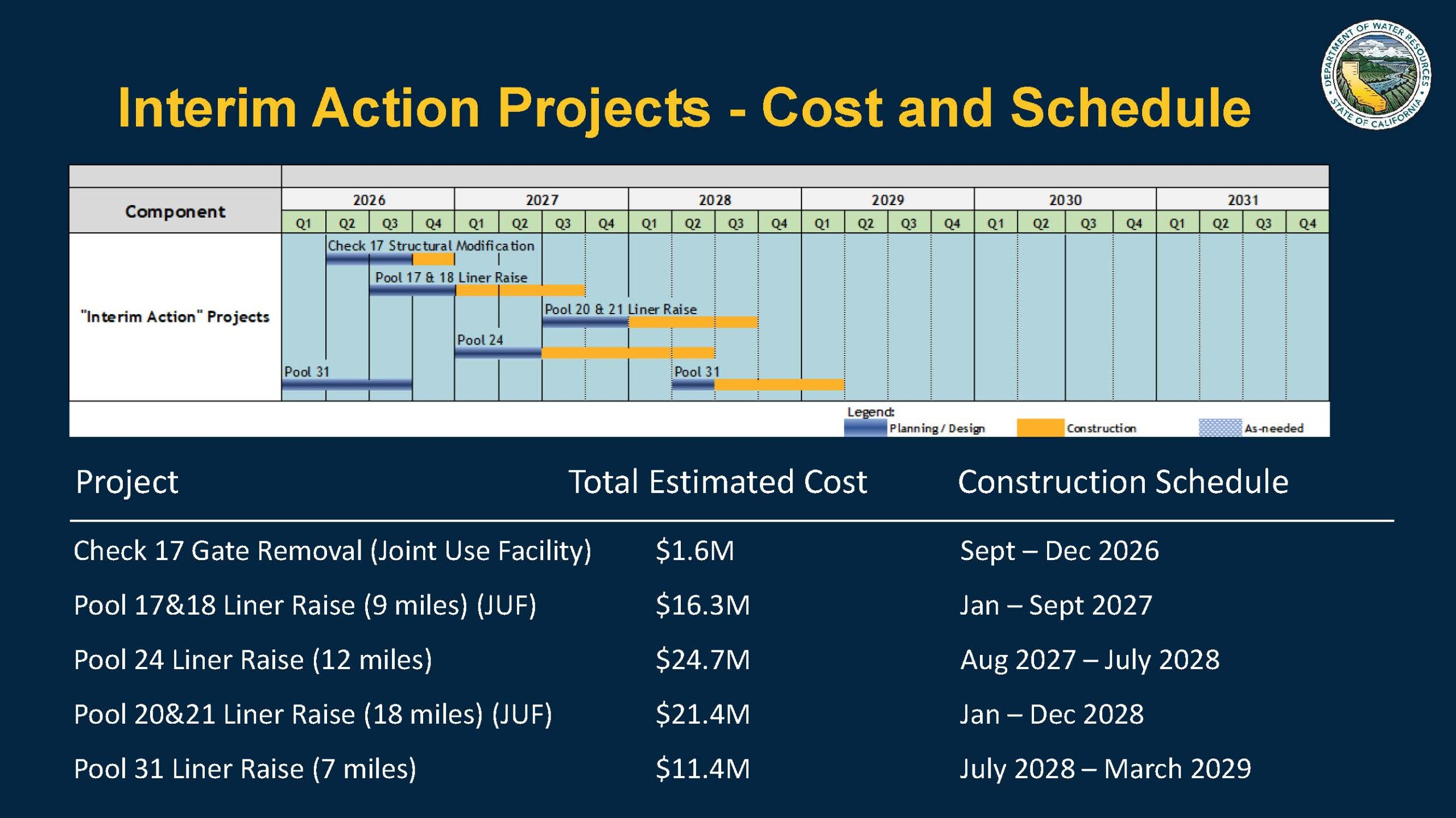
DWR has identified five interim projects for construction. Work on the first project is scheduled to begin this fall, with all five projects expected to be completed by spring 2029. The first step is removal of the control structure at Check 17, followed by an initial liner raise in Pools 17 and 18 and additional liner raises in subsequent years.
The chart below shows how the interim actions would improve aqueduct capacity from north to south. The black line represents original conveyance capacity as constructed in the 1960s and early 1970s, declining along the route as water is delivered through turnouts. The gold line shows capacity reduced by subsidence, the blue line shows capacity under special operating rules, and the peach line shows projected design capacity if no action is taken.
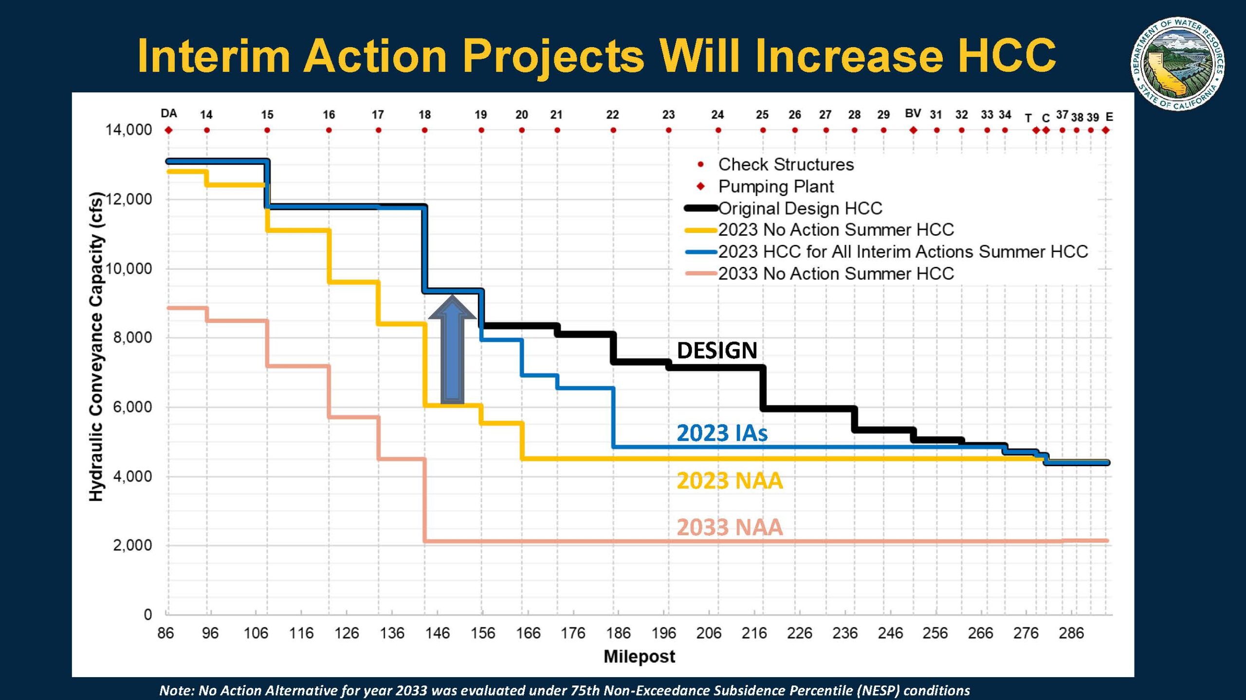
“So if we implement all five interim actions, we’re back up with something approximating design capacity, from the time we finish the interim actions until the time we’re ready to start implementing a long-term solution,” said Mr. Martin. “So, in a wet year, if you use 2020s hydrology and model it at 2023 subsided capacity value, we’d be looking at a roughly 9% delivery reduction. If you take that same 2020 hydrology and you run it through an aqueduct using the 2033 no action alternative, that could be as bad as a 61% delivery decline. Now the good news is with the interim actions you run that same hydrology, and we’re round about 2% decline in a wet year, so substantially better.”
Subsidence has its largest operational effects in wet years. With reduced conveyance capacity, moving Table A supplies through the aqueduct takes longer, reducing the system’s ability to carry other supplies, including non-SWP water and Article 21 water.
He also said the interim projects would bring capacity close to original design levels, but the aqueduct would still operate at one foot of freeboard. That would leave less flexibility in the timing of water movement, limit the ability to convey other supplies, and reduce opportunities to run pumps when power is less expensive. The interim projects also do not address the risk of additional subsidence through 2085.
DWR said it is on track to secure significant funding for the interim program. In March, the U.S. Department of the Interior announced $50 million for repairs to the San Luis Canal, part of the joint-use facilities. In California, the Newsom administration has proposed $45 million from Proposition 4 bond funds for the State Water Project share of subsidence repairs, a proposal that so far has drawn no opposition.
“Obviously, we won’t know finally until the legislature acts, but this is the, represents the strong desire of the administration,” said Mr. Martin.
Long-term actions
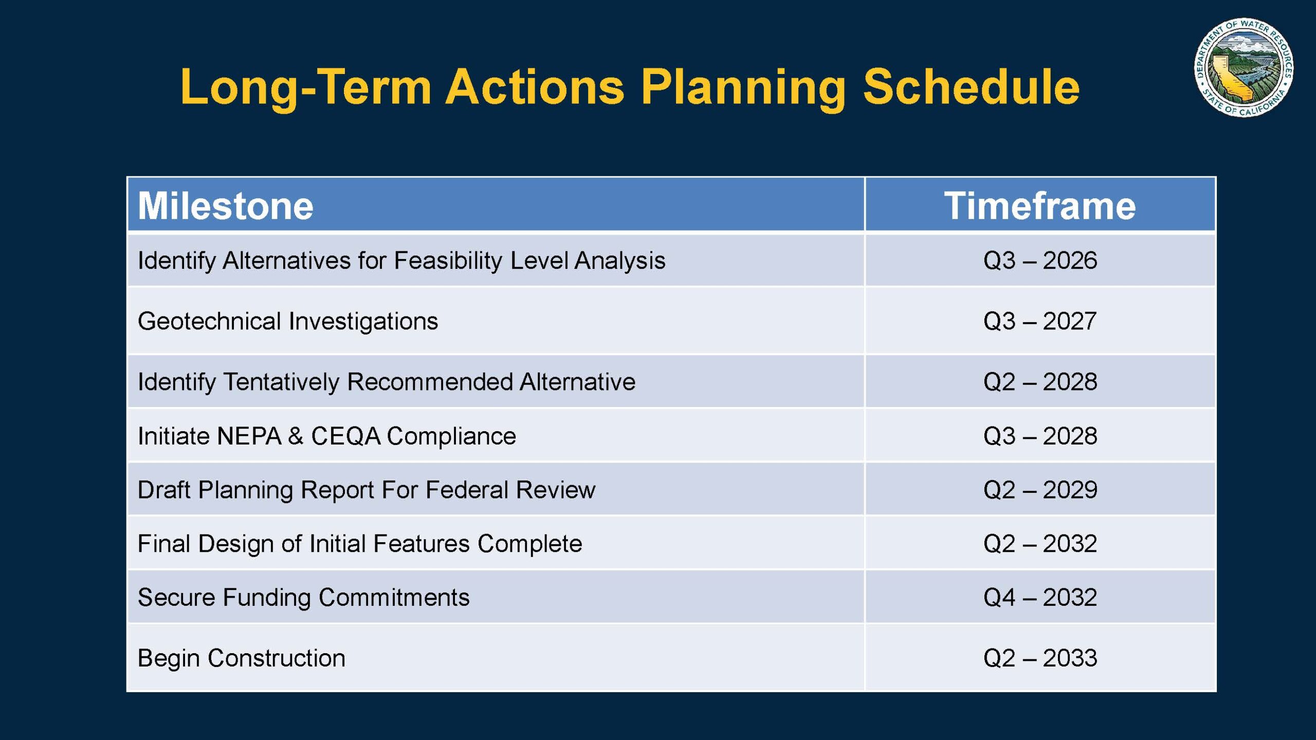 DWR said restoring the aqueduct’s original capacity and operational flexibility will require a longer-term program. Draft planning goals call for restoring and maintaining original hydraulic conveyance capacity, avoiding delivery and operational constraints caused by past and projected subsidence through 2085, preserving the ability to divert CVP and SWP contract supplies at designated locations, and maintaining the structural integrity and operating flexibility of San Luis Canal and aqueduct facilities affected by subsidence.
DWR is also working with the groundwater sustainability agencies responsible for lands along the aqueduct. Since enactment of SGMA, those agencies have been developing groundwater sustainability plans intended to bring basins into balance by 2040, and DWR is incorporating that information into alternatives being advanced for analysis, environmental review, engineering, design, and eventual construction.
Initial estimates put the cost of restoring the California Aqueduct to its original design specifications at about $4 billion, including raising bridges and pipelines and restoring as much freeboard as possible. “We’re looking at a number of alternatives,” said Mr. Martin. “We met with the Bureau and a number of large contractors attended to look at potential alternatives. We are receiving input from contractors about what are their concerns, what are their future needs, do they have better ideas for alternatives, ideas that could be cost saving or more cost efficient? We’re very aware that affordability is an issue, so we’re listening and we’re doing what we can to plan with that in mind.”
He said the interim actions would bring the aqueduct close to original design capacity, but only under special operating rules, underscoring the need for long-term actions to fully restore operational flexibility. “The capacity we’re getting there is by running the pumps 24/7 for longer, farther into the fall than we would otherwise. That means that we can’t move as much article 21 water, we can’t move supplies that you may have traded, exchanged, or purchased. Some contractors have said that that it is the existence of the aqueduct in that capacity that is as important to them as the SWP table A supplies themselves.”
FOR MORE INFORMATION: The California Aqueduct Subsidence Program, webpage at DWR

