
A wrap-up of posts published on Maven’s Notebook this week …
Note to readers: Sign up for weekly email service and you will receive notification of this post on Friday mornings. Readers on daily email service can add weekly email service by updating their subscription preferences. Click here to sign up!
In California water news this week …
Storms to bring rain, thunder and Sierra Nevada snow to California
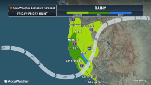 “A pair of storms will move into California and then the Southwest through this weekend, bringing much-needed rain, gusty thunderstorms and the risk of travel-snarling snow in the high elevations along Interstate 80. The first, and warmer, of the two storms will move inland across California through Friday then weaken over the interior West this weekend. Most of its moisture will be wrung out over California as showers, with only a bit of snow over the highest terrain in the northern Sierra Nevada and Siskiyous. Showers can occur at any time in San Francisco through the weekend due to both storms, with the second moving ashore in Northern California later Saturday before drifting inland Sunday. The first showers may not reach Los Angeles until Friday afternoon, while San Diego should remain dry until Friday night. … ” Read more from AccuWeather.
Record heat sizzled away the snow. Here’s how California is preparing for what’s ahead
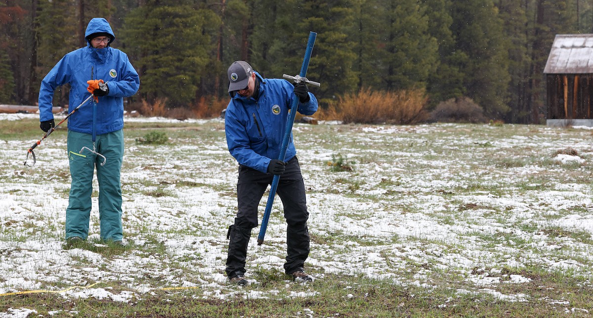
“The Department of Water Resources found no measurable snow April 1 at a place in the Sierra Nevada mountains where more than two feet of snow stood in late February. A record-breaking hot and dry March sizzled away the snow, leaving a field of mud and grass. “Are we heading into hydrologic drought?” said DWR Director Karla Nemeth at the snow survey. “The answer is, I don’t know. We could be . . . we’ll know with more clarity next year if this year in fact is the start of a hydrologic drought in California and throughout the West.” Whatever future conditions hold, California is better prepared than ever for drought. Major, recent investments and policy changes have strengthened the capacity of small and large water systems to cope with prolonged lack of precipitation. … ” Read more from DWR.
California and the West’s current snow drought in a long-term context: key points for researchers
“We are well into the 2026 water year in the western United States, and so far, it appears to be an unseasonably warm one. Media across California, the western states, and the nation are covering the impact of our warm winter on snowpack and water resources. This post attempts to put headlines and current events into a longer-term context, explaining long-term changes we expect in snowpack water storage. In late January and early February, the LA Times reported that snowpack in the Sierra Nevada was about 59% of average for that time of year. The San Francisco Chronicle noted a particularly significant snow deficit in the Northern Sierra, and that the culprit was largely not lack of precipitation, but rather early onset of melt. And the New York Times commented that a snow drought has gripped not only California but also the rest of the West, likely foretelling diminished runoff later this year. More recently, record spring heat across California and the West has driven a “snow-eater heatwave”, melting out much of the already-meager snowpack (Rhoades et al. 2025). … ” Read more from the California Water Blog.
Strongest El Niño in 140 years? This one could actually deliver for California
“A rare cluster of three tropical cyclones will straddle both sides of the equator in the western Pacific this week, generating what one scientist called potentially the strongest westerly wind burst over the equatorial Pacific in the recent century. The burst is pushing warm water eastward at a critical moment, accelerating what Paul Roundy, an atmospheric scientist at the University at Albany, said has “real potential for the strongest El Niño event in 140 years.” The just-released April seasonal forecast from the European Centre for Medium-Range Weather Forecasts shows virtually all of its models expect the world to reach El Niño conditions by mid-June. Roughly half project sea surface temperature anomalies exceeding 2.5 degrees Celsius above average by October. … ” Read more from the San Francisco Chronicle. | Read via Yahoo News.
SEE ALSO: A Super El Niño is coming. Here’s how a hotter ocean could change the weather near you, from CNN
A biblical megaflood could hit California at any moment. And that’s only the beginning
“California. The Golden State. Home to almost 40 million people and the world’s fourth-largest economy, it is a global capital of technological innovation and the epicentre of the entertainment industry. But beneath the glitz and glamour, prosperity and prestige, the state is a natural disaster hotspot. From earthquakes to wildfires, Californians are accustomed to battling the forces of nature. … California is built on extremes at both ends. Alongside vast wealth sits deep poverty; alongside years of drought and fire come episodes of torrential rain and devastating floods. Only in 2023, hundreds of thousands were left without power as storms and flooding battered the state. Highways collapsed, trains derailed, and thousands were evacuated from their homes. That sounds bad enough, but according to the latest research, episodes like this pale in comparison to what’s to come. Scientists and officials are now preparing for not one threatening storm, but a 30-day maelstrom of megastorms unlike anything seen in the state for almost 200 years. … ” Read more from BBC’s Science Focus.
Turning flood risk into water supply: Inside DWR’s San Joaquin Basin Studies
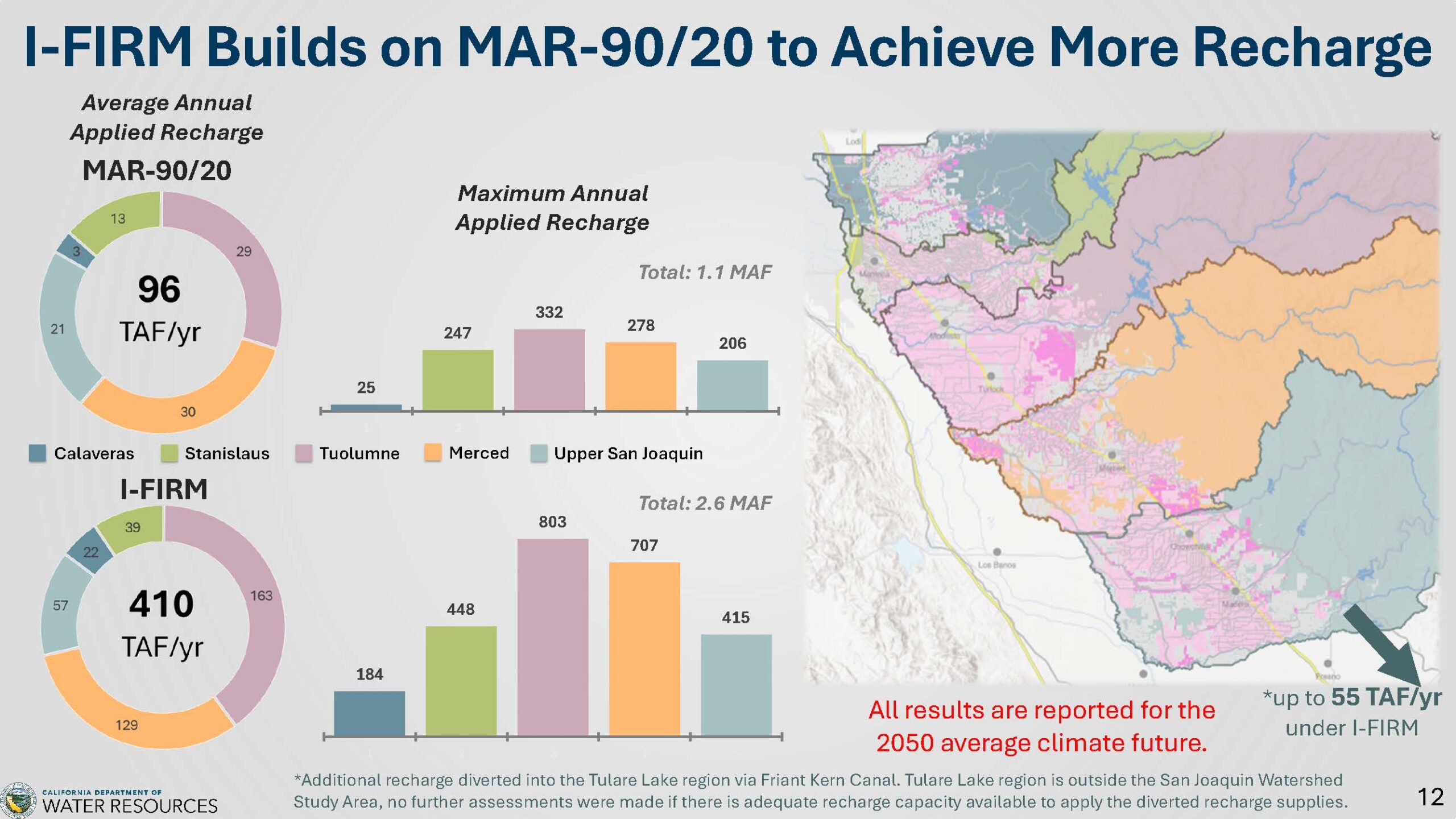 “The San Joaquin Basin faces complex water management challenges that demand a unified approach. Decades of groundwater overuse, increasing flood risks, and the accelerating impacts of climate change threaten the region’s water supplies, communities, agriculture, and ecosystems. To address these issues, the Department of Water Resources (DWR) has undertaken a series of interconnected studies, including the San Joaquin Basin Flood-MAR Watershed Studies. These efforts highlight a critical insight: the whole is greater than the sum of its parts. Implementing strategies like Integrated Forecast-Informed Resource Management (IFIRM) across all watersheds is essential to maximize benefits. Achieving this will require unprecedented coordination among multiple agencies—a challenging but achievable goal that holds the promise of a more resilient future for the entire basin. The San Joaquin Basin Flood-MAR Watershed Studies are one of three related DWR efforts that, together, provide a holistic look at water management challenges and options across the San Joaquin Valley. … ” Continue reading at Maven’s Notebook.
Endangered salmon returned to California’s far north — then the money dried up
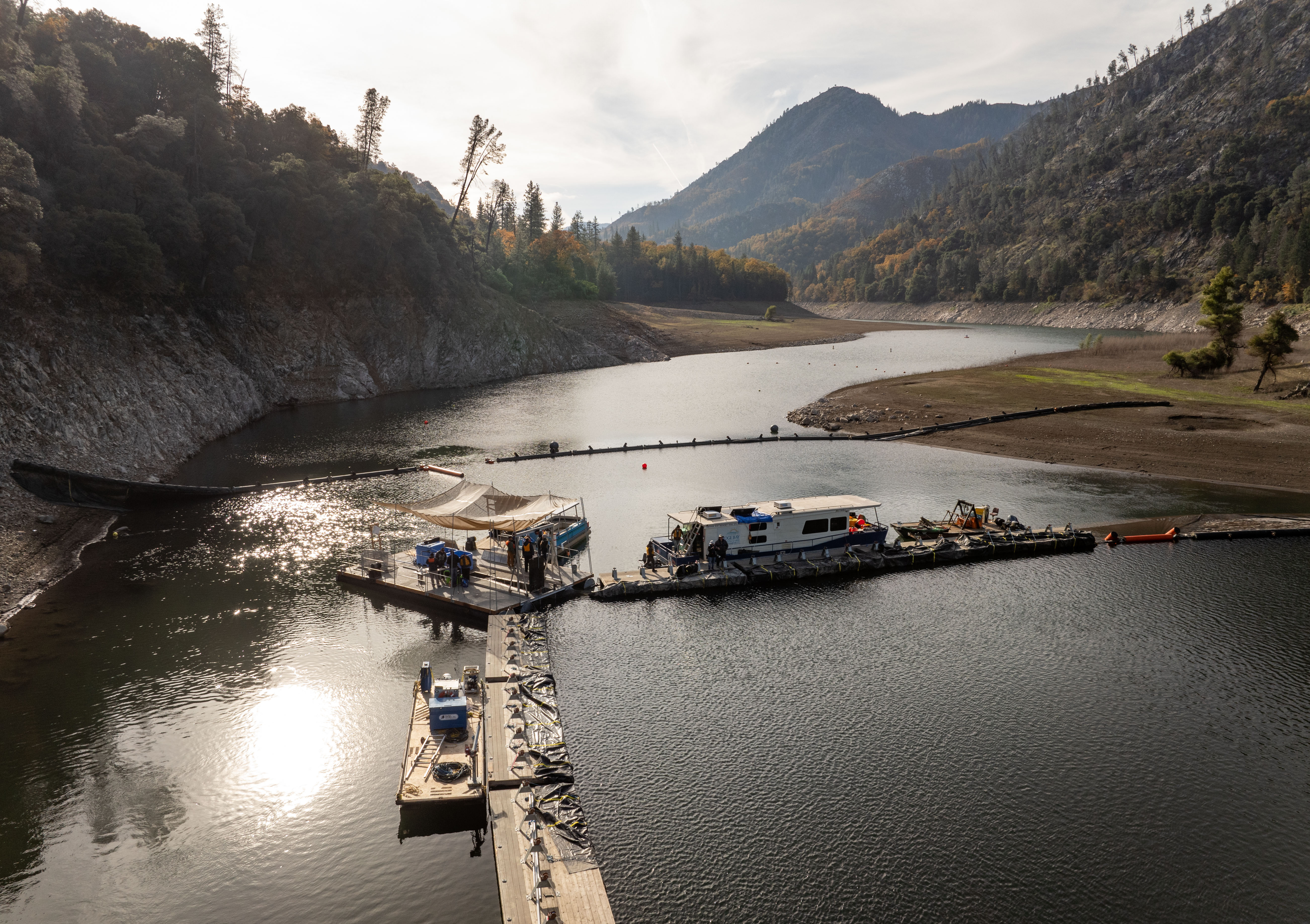
“Two years ago, Gov. Gavin Newsom unveiled a strategy to save declining salmon — spotlighting a historic partnership with the Winnemem Wintu Tribe to reintroduce endangered winter-run Chinook to the vital, cold waters upstream of Lake Shasta in far northern California. Now, tribe officials say the state is ending its support, potentially causing salmon restoration efforts on the McCloud River to die mid-stream. The tribe is now grappling with the sudden loss of jobs, along with the dimming of hope that the culturally sacred fish will be restored to their ancestral waters. “It makes me feel betrayed. It makes the tribe feel betrayed,” said Gary Mulcahy, government liaison for the tribe. “It’s like they just gave up.” “The pilot was designed to take urgent action during severe drought conditions while testing key tools and approaches needed for potential long-term reintroduction,” California Department of Fish and Wildlife spokesperson Stephen Gonzalez said in an email. … ” Read more from Cal Matters.
Fourth San Joaquin Valley groundwater region avoids state intervention
“The state Water Resources Control Board unanimously approved releasing the Delta-Mendota subbasin from potential enforcement actions at its April 7 meeting. “The metrics I think about, and that I’ve mentioned at a number of other probationary discussions, is: progress, not perfection is what we’re looking for,” Water Board member Sean Maguire said before the vote. “I think what we’ve seen here from the basin is a willingness to coordinate amongst 23 different groundwater sustainability agencies.” Landowners in the region will escape probation, which requires growers to meter wells, register them at $300 each and pay $20 per acre foot pumped. … ” Read more from SJV Water.
Small pumpers excluded from state sanctions prompting backlash and allegations that some may try to game the system
“Though the state put groundwater pumping in Kings and Tulare counties under greater scrutiny in 2024, it gave some pumpers a pass on Tuesday, April 7, from having to report extractions and pay fees to the state. That prompted complaints of fairness from some groundwater sustainability agencies (GSAs) and concerns from others that some pumpers may be gaming the system. The Water Resources Control Board voted to exclude “small pumpers,” defined as 20 acre feet or less per year, from reporting and $20-per-acre-foot fee mandates required under probation in the Tule and Tulare Lake subbasins, which include most of Kings County and the southern half of Tulare County’s flatlands. The one caveat is that small pumpers within two miles of the Friant-Kern Canal – badly damaged by subsidence – must still report extractions and pay the fees. … ” Read more from SJV Water.
How much water do we have? Scientists map the water beneath our feet
“For scientists, measuring the water in a river or a lake is relatively straightforward. It’s much more complicated to figure out how much water lies underground. After years of research, a team of scientists has finally mapped what remains of these hidden waters across the United States, and they’ve produced the most extensive estimate of the country’s groundwater to date. Researchers at Princeton University and the University of Arizona took data from about 800,000 wells and applied a machine-learning model to estimate the depth of the water table nationwide. “Groundwater is out of sight and out of mind for most people,” said Reed Maxwell, a hydrologist at Princeton and co-author of the recent study in the journal Nature. “Knowing how much we have will be helpful in knowing how to use it wisely.” … ” Read more from the LA Times. | Read via Boiling Point Newslettter.
Will data centers threaten California’s water? It’s complicated.
“The explosive growth in data centers is fueling concerns in California, as well as across the country, about water and energy use. Some have gone as far as to propose a water usage fee on data centers. However, others argue that data center water use is just a drop in the bucket compared to other uses or that most data centers are moving toward less water-intensive practices, such as reusing water in closed-loop systems. To help us understand what we do and don’t know about California data centers and water use, we spoke with Dr. Marie Grimm, an environmental policy research fellow at UC Berkeley’s Center for Law, Energy, & the Environment, about their new report “Regulating Data Center Water Use in California.” What is a data center, and how does it use water? A data center is a facility that houses servers, digital storage systems, and network infrastructure. We use data centers every day—this Zoom meeting is probably running through a data center. … ” Read more from the PPIC.
Someone may have maliciously caused a huge rodent invasion in California
 “For years now, California has been waging war on nutria, a highly destructive 20-pound rodent native to South America that poses a serious threat to fragile wetlands and endangered species. And now, wildlife officials say it’s possible that someone intentionally reintroduced them. According to an April 7 news release from the California Department of Fish and Wildlife, genetic sequencing has revealed that the state’s nutria populations are most genetically similar to populations in Oregon, suggesting that, “California’s current nutria invasion was the result of intentional reintroduction, with the original source animals likely being transported from the central Oregon population.” … ” Read more from SF Gate.
Coalition urges lawmakers to reject bill threatening water oversight
“A coalition of Tribes and environmental advocates has submitted a letter to the California Assembly Committee on Water, Parks, and Wildlife opposing AB 2215. The bill, which seeks to extend the Department of Water Resources’ water rights permit for the State Water Project until 2085, is being criticized for bypassing existing regulatory processes managed by the State Water Resources Control Board (“Water Board”). “This bill would set an extremely dangerous precedent,” said Morgen Snyder, Director of Policy and Programs at Restore the Delta. “Protecting our waterways and the communities that depend on them requires maintaining rigorous standards for all water rights holders. Granting exemptions that override existing processes creates a system that favors powerful users at the expense of ecosystem and community health.” … ” Read more from Restore the Delta.
A Southern California lawmaker wants to ban ‘forever chemicals’ on state crops
“Home to the nation’s largest agricultural industry, California produces nearly half of the country’s vegetables and more than three-quarters of its fruits and nuts. And, on average, 2.5 million pounds of pesticides containing toxic perfluoroalkyl and polyfluoroalkyl substances (PFAS) – so-called “forever chemicals” – get sprayed on these crops every year, according to some environmental advocates. To address growing concerns about the adverse impacts these substances have on the environment and human health, Assemblymember Nick Schultz, D-Burbank, has introduced a bill to phase out the use of PFAS pesticides in the state. … ” Read more from the LA Daily News.
These California research stations prepare for fire risk. The Trump administration is shutting them down
“The Trump administration announced this week it will shut down six of eight U.S. Forest Service research facilities in California as part of a major national reorganization that could leave the state underequipped to manage escalating wildfire and drought threats. The closures in Fresno, Chico, Fort Bragg, Mount Shasta, Anderson and Hat Creek in Shasta County are part of a broader plan announced this week to shutter 57 of the agency’s 77 research facilities across 31 states and move its headquarters from Washington, D.C. to Salt Lake City, Utah. In California, just two research facilities will remain, in Placerville and Riverside. The closures come amid record warm winter temperatures in California that have rapidly eroded the state’s snowpack and heightened concerns that wildfire season could come early. Scientists at the research facilities study how forests change over time, including how they recover following fires. … ” Read more from the San Francisco Chronicle. | Read via MSN News.
In commentary this week …
This California lake revolutionized American environmental law
Caroline Tracey, author of “Salt Lakes: An Unnatural History, writes, “Mono Lake stands out in the high desert of eastern California, a disc of blue amid a landscape of sagebrush and sandy soil. In 1872, Mark Twain called it “this lonely tenant of the loneliest spot on earth.” Lonely as it may be, legal cases involving Mono have revolutionized environmental law in California, the American West and the U.S., bringing about important changes to water use and air quality regulations in recent decades and showing the way ahead for tribal resource rights today. In the early 20th century, the Los Angeles Department of Water and Power built the Los Angeles Aqueduct to capture snowmelt from the eastern face of the Sierra Nevada and channel water to the city. Within a decade, California’s Owens Lake, where the water had naturally flowed and collected for thousands of years, dried up. In 1941, the Los Angeles utility added an extension that allowed it to drain water from the nearby Mono Basin, tapping rivers and streams that had long fed Mono Lake. … ” Read more from the San Francisco Chronicle.
U.S. water infrastructure is vulnerable to hacks. Iran knows it.
Jake Braun, executive director of the Cyber Policy Initiative at the University of Chicago Harris School of Public Policy, writes, “No matter what becomes of the Iran war ceasefire, another form of warfare waged by Tehran against the United States is almost certain to continue: cyberattacks on the water supply. The U.S. Cybersecurity and Infrastructure Security Agency warned on Tuesday that last month a U.S. water facility was hit with more than 1,900 hacking attempts from around the world, with Iran the principal source of the attacks. While these hacking attempts failed, the effort is not new. Adversaries are constantly looking for weaknesses to exploit in America’s infrastructure. Since water is so essential to daily life, these facilities are a favorite target.The vulnerability of water infrastructure has become a recurring theme in the Iran war. … ” Continue reading at the Washington Post.
Cadiz Inc.’s water extraction scheme threatens our traditional territories
“Daniel Leivas, chairman of the Chemehuevi Indian Tribe, and Timothy Williams, chairman of the Fort Mojave Indian Tribe, write, “Our tribes — the Chemehuevi Indian Tribe and the Fort Mojave Indian Tribe — have lived and stewarded lands in the California desert since time immemorial. These are our traditional territories, and we are physically and spiritually connected to the land. Groundwater-fed springs in the desert are sacred to our tribes and give life year-round to plants and animals, including bighorn sheep, mountain lions, and bobcats. All these species and more are part of a connected landscape found in our stories, songs, and ceremonies. For over 40 years, our traditional territories have been targeted for the corporate extraction of vulnerable desert water resources by Cadiz, Inc., a foreign investor-backed company. We have successfully opposed their efforts to extract and sell desert ground water, but still they continue to pursue an unrealistic scheme to drain the desert to make a profit for their shareholders. Today, we write to urge others – both tribal nations and tribal allies to stand with us – in solidarity against Cadiz’s efforts. Here’s why. … ” Read more from Indian Country Today.
Data center water use not sustainable in increasingly dry American West
Amanda Claire Starbuck, research director at Food & Water Watch, writes, “After years of failed negotiations between the states and decades of negligent water management, we now have just months for federal officials to decide how to divide up the ever-shrinking flow of the Colorado River between the seven river basin states that share it — and the 40 million people relying on the river for drinking water, including right here in Colorado. As we wait with bated breath for a conclusion, another major threat to our precious water in the American West is emerging: hyperscale data centers. If we don’t immediately halt this buildout, we will continue the legacy of failed water management of the river: giving our water away to polluters and profit-hungry developers at the expense of our communities and our future. … ” Continue reading at the Colorado Newsline.
In regional water news this week …
Klamath irrigation supply will be ‘woefully’ short
“The U.S. Bureau of Reclamation announced an initial water supply of 221,000 acre-feet from Upper Klamath Lake, just over half of what is needed for local farmers, ranchers and other irrigators, according to the Klamath Water User Association. The organization described the supply as “woefully short of need.” “It’s much less than what we want to hear, although realistically not less than what we expected at this time,” said Elizabeth Nielsen, KWUA executive director. “The entire west is in a drought, with negligible snowpack remaining in the Klamath Basin. On top of that, we have an unworkable set of regulatory requirements that can’t be changed in time for this season,” Nielsen added, in a news release. … ” Read more from the Capital Press.
Inside California’s audacious bid to build the world’s deepest floating wind farm
“Here along the rugged North Coast of California, there’s little to suggest that Humboldt Bay, with its eelgrass, oysters and osprey nests, will soon become a launchpad for one of the most ambitious clean energy projects in state history: a hub for floating offshore wind. The plan is for major private players to erect hundreds of wind turbines in the bay — each rising as high as L.A.’s tallest skyscrapers — then tow them out to the ocean. Some experts believe the wind project is critical to California’s goal of 100% carbon neutrality by 2045 and represents a key climate change solution. The state has a target of 25 gigawatts of offshore wind energy by that year — enough to power about 25 million homes — and nearly all of it would come from five lease areas in federal waters near Humboldt and Morro bays. Yet the technology for wind power that floats — as opposed to standard towers permanently attached to the sea floor — is just emerging, and has never been attempted in waters as deep as the Pacific off Northern California. … ” Read more from the LA Times. | Read via Yahoo News.
How a new dredging approach could benefit a Marin County creek, protect Bay marshes
“It is hard to think of a tidal marsh as being in danger of sea level rise. After all, it is already surrounded by water. But a tidal marsh — like the 100-acre wetland at China Camp State Park in southern Marin County — is essentially a water garden that depends on sunlight and shallow shores. Its grasses shelter unique fish that feed birds and special status species like the salt marsh harvest mouse and golden eagles. As seas rise, marshes can drown and become open water, wiping out entire ecosystems that people and animals depend on unless they are replenished with new sediment. A pilot project underway in Marin County could open the door to a new, lower-cost and lower-carbon method of wetland restoration by sending waves of new sediment from areas of human settlement into nearby marshes. … ” Read more from Local News Matters.
Water quality enforcement penalties boost Salinas River beaver renaissance
“Funding from a 2021 settlement agreement between the Central Coast Regional Water Quality Control Board and Pacific Gas and Electric Co. is supporting the Drinkable Rivers Program in San Luis Obispo County, a program that puts elected officials, students and others on the water to witness the benefits of beaver dams and ponds. “The program not only helps the river, wildlife and the environment, it also directly involves the public,” said Ryan Lodge, executive officer of the Central Coast Water Board. “Providing hands-on experience for people who care deeply about the environment builds support for protecting the Salinas River in the long term. Additionally, the settlement with PG&E for water quality violations illustrates how our enforcement actions can both serve as a deterrent and lead to measures that benefit the public and the environment.” … ” Read more from the State Water Board’s Ebb and Flow.
Controversial mining project on Conglomerate Mesa greenlighted despite widespread opposition
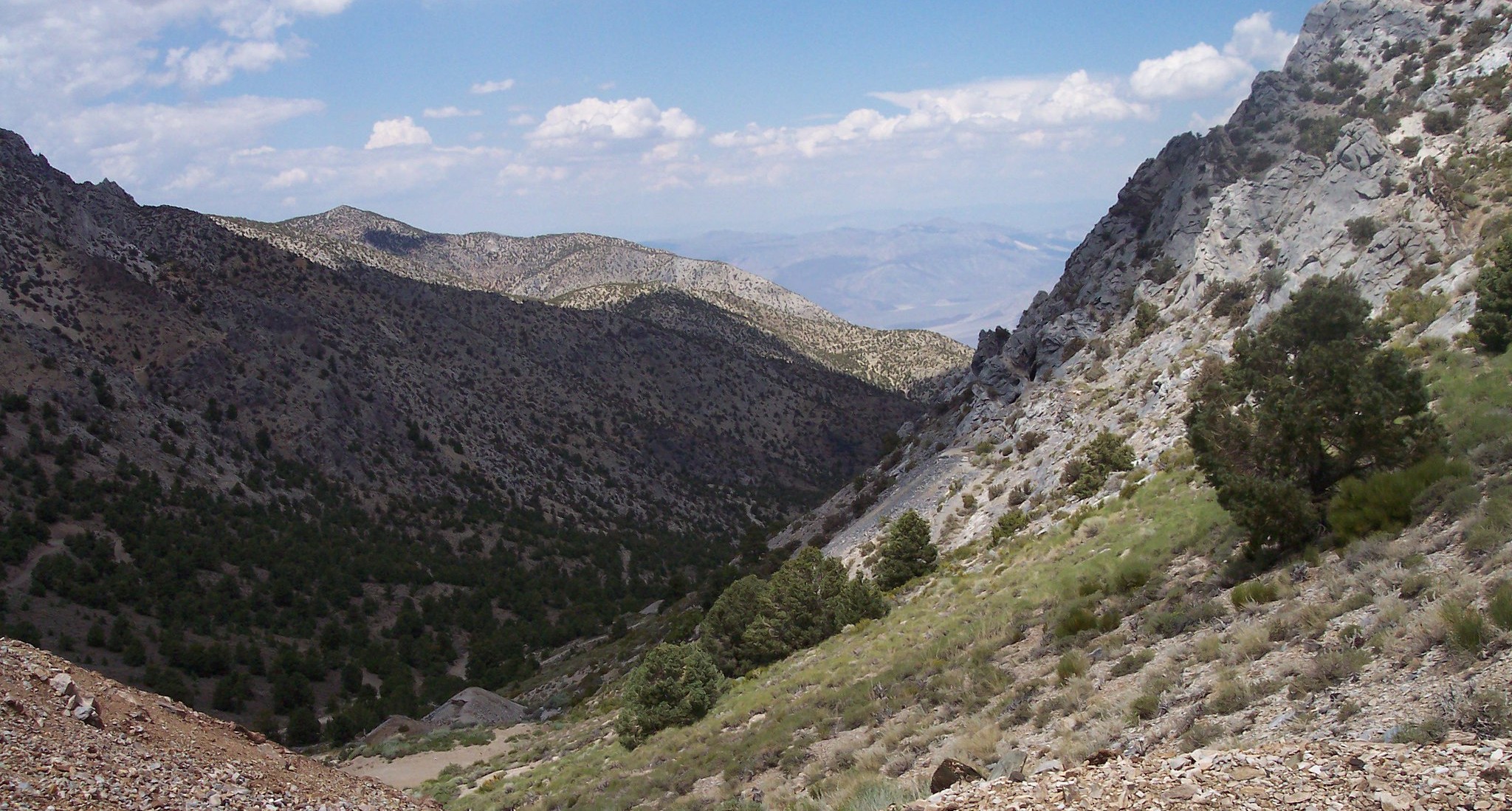
“On April 6, 2026, the Bureau of Land Management approved a proposal for an expanded mining exploration drilling project at Conglomerate Mesa, located on traditional homelands of the Paiute-Shoshone and Timbisha Shoshone and about one mile west of California’s Death Valley National Park. In a letter of opposition, the Lone Pine Paiute-Shoshone Reservation stated, “The Lone Pine Paiute Shoshone Tribe has concerns for the area, as it was used by our people long ago when they traveled through to other areas; our people picked pine nuts, hunted, and camped there. Traces of our uses are still relevant today. It would be a shame to open it up to mining, which we are opposed to.” In this next phase of destructive gold mining exploration, Canadian company K2 Gold, through its subsidiary Mojave Precious Metals, had proposed significant new road construction and 120 drill holes at 30 sites on Conglomerate Mesa. After receiving over 14,000 public comments on the Draft Environmental Impact Statement (DEIS), mostly in opposition to the project, the BLM and the mining company decided to opt for an alternative that limits the exploration to 76 drill holes at 22 sites, with no road construction and access via “helicopter only.” … ” Continue reading this press release from Friends of the Inyo.
Meant to filter storm water, LA’s bioswales are now dumping grounds
“Across from an auto shop on Venice Boulevard and Albany Street sits a narrow, sunken strip of land lined with overgrown shrubs and cacti. It’s mostly filled with trash — from plastic bags and cups to containers, straws, chip bags and aluminum foil. It’s original purpose was to capture and filter storm water runoff, helping reduce flooding and keep pollutants from flowing into the ocean. But neighbors in Pico Union say that this bioswale and many others across the city have become dumping grounds. … Local resident Aurora Corona — a longtime Pico Union community organizer involved in local environmental and cleanup efforts — said in some instances it looks like the bioswales were not fully installed. Citywide, there are about 23 bioswales that appear abandoned, Corona said. Many are located in central and South Los Angeles and spread across at least eight council districts. … ” Read more from the LAist.
New wetland brings life to L.A.’s industrial river corridor
“After devastating floods in the 1930s, the LA River was wrapped in concrete, basically turning it into a giant 51-mile storm drain. That stopped the flooding, but it also severed ecosystems and cut Angelenos off from accessing the waterway that flows through the city. For decades, myriad public agencies, environmental groups and nonprofits have slowly, bit by bit, been renaturalizing the river and creating new life in the corridors around it. Now, that dream is taking another step forward with a plan to transform 100 acres of land next to the LA River into a massive state park – the largest, continuous open space along the waterway. In an industrial area of Frogtown, crews are turning an old rail yard into both a wetland and a public park. It’s about two-thirds complete and will likely open sometime next year. “What’s happening on the river right now is a once-in-a-generation transformation of industrial land into public green space,” says Candice Dickens-Russell, CEO of the Friends of the LA River. “And that’s worth getting excited about.” … ” Read more from KCRW.
Colorado River supply forecast melts after March heat wave
“Last month’s record breaking heat across the Mountain West led to the worst snowpack on record in Colorado and Utah, along with a significantly downgraded forecast for the upcoming supply of Colorado River water. Cody Moser with the federal Colorado Basin River Forecast Center said in a monthly briefing Tuesday that just 1.4 million acre feet of Colorado River water is expected to reach Lake Powell through July. That’s less than a quarter of what’s considered normal. It’s also much lower than the 2.3 million acre feet Moser’s office projected a month ago, before the heat wave in the West melted away an already meager supply of snowpack. “With record low snow pack, we have well below normal water supply forecasts,“ he said. “In many cases, our April through July (water) volume forecasts rank in the lowest five on record when compared to historical observations.” … ” Read more from KUNC.
Lake Mead drops more than 6 feet since March, nearing record low
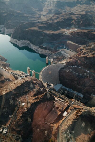 “Lake Mead has dropped more than 6 feet since March 1 and now sits just 20 feet above its all-time low from July 2022, with water levels expected to fall even lower soon. The dropping water level has created challenges for boaters and raised questions about Southern Nevada’s water supply. FOX5 spoke with boaters and the Southern Nevada Water Authority about the conditions. “I was shocked when I came down and saw how low the water was,” said Ron Klug, a longtime boater. … ” Read more from Channel 5.

