
The San Joaquin Basin faces complex water management challenges that demand a unified approach. Decades of groundwater overuse, increasing flood risks, and the accelerating impacts of climate change threaten the region’s water supplies, communities, agriculture, and ecosystems. To address these issues, the Department of Water Resources (DWR) has undertaken a series of interconnected studies, including the San Joaquin Basin Flood-MAR Watershed Studies. These efforts highlight a critical insight: the whole is greater than the sum of its parts. Implementing strategies like Integrated Forecast-Informed Resource Management (IFIRM) across all watersheds is essential to maximize benefits. Achieving this will require unprecedented coordination among multiple agencies—a challenging but achievable goal that holds the promise of a more resilient future for the entire basin.
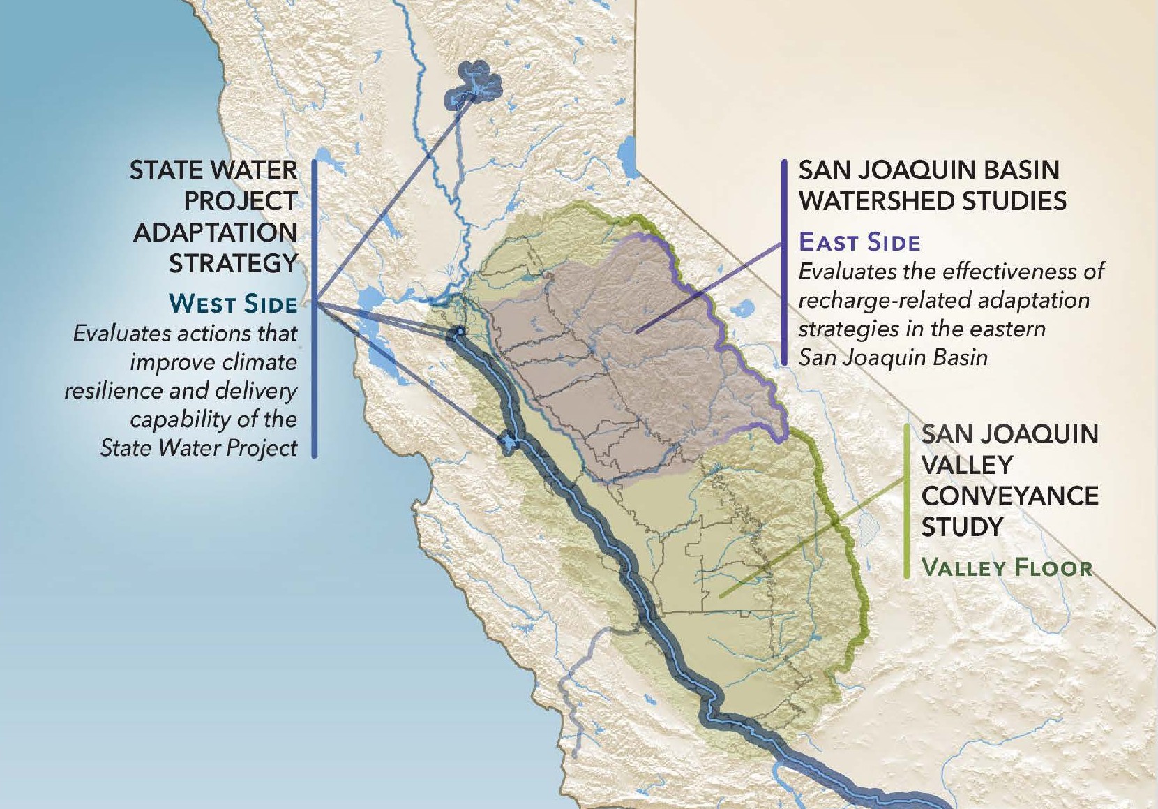 The San Joaquin Basin Flood-MAR Watershed Studies are one of three related DWR efforts that, together, provide a holistic look at water management challenges and options across the San Joaquin Valley. The Watershed Studies examine water management in the Calaveras, Stanislaus, Tuolumne, Merced, and Upper San Joaquin watersheds and suggest ways the region can adapt to a changing climate. The second report, the State Water Project Adaptation Strategy, evaluates actions to improve the climate resilience and performance of the State Water Project on the west side of the Valley. The third report, the San Joaquin Valley Conveyance Study, examines valley-floor conveyance needs and the growing risks to water management.
The main goal of the Watershed Studies was to determine how capturing and storing floodwater underground, known as Flood-Managed Aquifer Recharge (Flood-MAR), can help refill aquifers and manage floods better in California’s changing climate. At a December Lunch-MAR meeting, David Arrate, a water resources engineer with the Department of Water Resources, shared the study’s results.
STUDY BACKGROUND
The study looked at five watersheds: Calaveras, Stanislaus, Tuolumne, Merced, and the Upper San Joaquin. The Upper San Joaquin includes three connected watersheds—San Joaquin, Fresno, and Chowchilla—which were grouped together because the Madera Canal links them all, running from Millerton through each one.
The study’s objectives are to assess the San Joaquin Basin’s climate vulnerability by examining water supply—including both surface and groundwater, flood risk, and ecosystem impacts; to evaluate the adaptation potential of Flood-MAR strategies for mitigating climate change effects and improving sector benefits; and to foster partnerships aimed at advancing Flood-MAR implementation. Study partners included the U.S. Army Corps of Engineers, the Bureau of Reclamation, the Department of Water Resources, the Center for Western Weather and Water Extremes, and irrigation districts and other local agencies throughout the watersheds.
The studies consider two strategies:
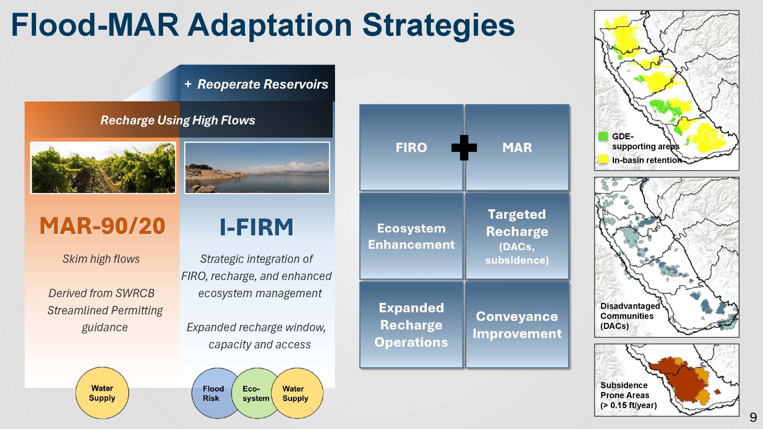
- MAR 90/20 follows the State Water
 Resources Control Board’s streamlined permitting rules, allowing water to be diverted when river flows are above the daily 90th percentile, up to 20% of the flow. By capturing these high flows, water is sent to recharge areas. This method keeps more water in the basin, supports groundwater-dependent ecosystems, improves groundwater for disadvantaged communities, and addresses areas in the valley experiencing subsidence.
 - IFIRM (Integrated Forecast-Informed Resource Management): IFIRM centers on reoperating reservoirs using forecast-informed reservoir operations (FIRO) coordinated with MAR strategies. It encompasses infrastructure improvements, off-channel habitat restoration, and reservoir reoperations to enhance ecosystem flows. IFIRM builds on MAR 90/20 by broadening recharge operations—expanding the time window, geographic footprint, and including “in-lieu” recharge using available MAR water. The approach also incorporates conveyance upgrades through irrigation districts and represents an expansion of both operational and infrastructure elements compared to MAR 90/20.
FIRO MAR
To determine how much water FIRO operations could provide, the study measured the flood space available and the capacity of the downstream channels, and set guidelines for what counts as FIRO space.
First, the team calculated how much water could be released over five days at the channel’s maximum capacity. Then, they looked at the reservoir’s total storage, aiming for about 5% of it. Next, they set the flood space size, usually between 10% and 20%, but not more than 50%. They fine-tuned the FIRO space by running several tests and simulations.
Mr. Arrate then gave an example using Lake McClure on the Merced River. The Merced River channel capacity downstream is 6000 CFS, so 6000 CFS at five days is about 60,000 acre feet, about 6% of total storage, and 17% of the flood space. That was then tested under a number of events, with and without climate change.
“The final determination was that 60,000 acre feet of FIRO space worked well for Lake McClure,” he said. “The idea was to try to maximize the benefits of the FIRO and FIRO Mar without inducing any kind of flood risks downstream by encroaching into the flood space.”
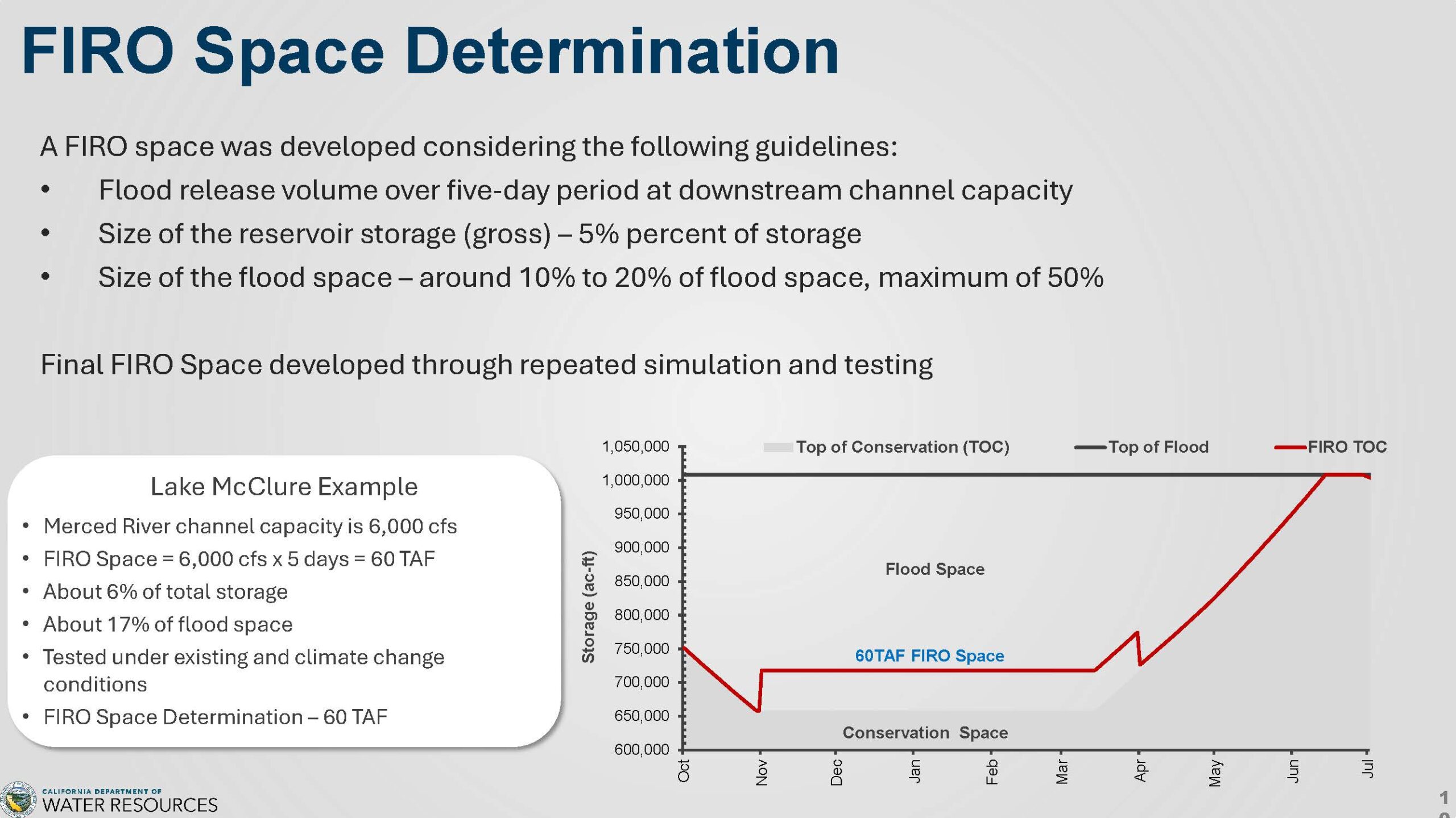
The graph, above right, shows the rule curve for Lake McClure. Conservation space is shown in gray, and flood space in light gray. The FIRO space, which is 60,000 acre-feet, is marked by a red line. FIRO operations run from November to the end of March.
The slide below illustrates the integration of FIRO and Flood-MAR operations during a hypothetical storm event at Lake McClure. Before the storm, reservoir levels remained below the flood space threshold. If forecasts indicate that the incoming storm will raise storage into the FIRO space, reservoir managers may initiate a conservation space pre-release (designated as #1 in the graphic), diverting water for recharge purposes to increase available flood space within the reservoir.
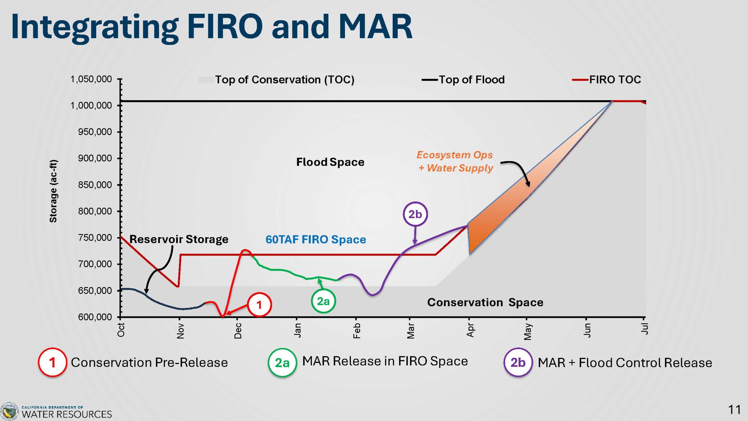
After the storm clears and the forecast predicts sunny weather, water from the FIRO space is released for groundwater recharge (see #2A in the graphic). Before this happens, all minimum downstream flow requirements must be fulfilled. Water is then discharged at a rate that optimizes diversion for recharge at the downstream site.
If another storm is forecast, flood releases may increase (#2B on the graph), combining with MAR releases to free up additional reservoir space. These releases can even extend into the conservation space to provide greater flood storage capacity in the reservoir.
The FIRO-MAR period ends in March. If water remains in the flood space, it can be used to support ecosystem functions such as shorebird habitat, spring pulses, or recession flows. Any remaining water may also be transferred to the reservoir’s supply as it returns to conservation space.
“So we try not to lose that water by making some other uses of it, focusing first on the ecosystem and then the water supply,” Mr. Arrate said.
KEY FINDINGS
Groundwater recharge
Using the MAR 90/20 approach, the average annual applied recharge is roughly 96,000 acre-feet per year. Most of this recharge occurs in the Tuolumne, Merced, and Upper San Joaquin watersheds, with additional contributions from Stanislaus and Calaveras.
When IFIRM is used and water is released more slowly from the reservoir, recharge jumps to about 410,000 acre-feet per year, especially in the Tuolumne and Merced watersheds. These are average numbers and can change a lot depending on whether the year is wet or dry. In dry years, recharge might be very low or not happen at all.
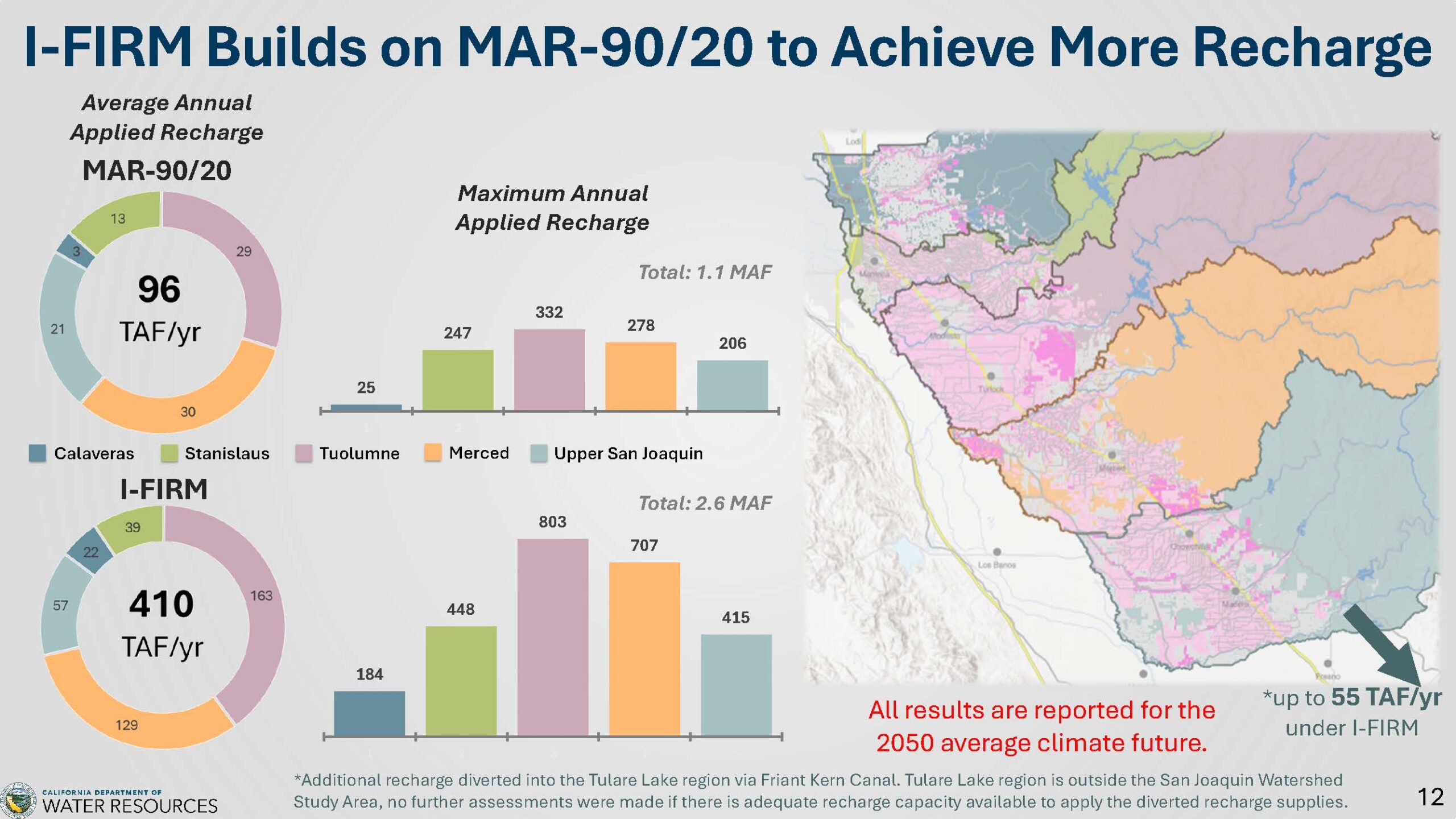
The highest annual recharge modeled for MAR 90/20 was up to 1.1 million acre-feet for the whole basin. With IFIRM, this more than doubled to about 2.6 million acre-feet. These numbers change a lot depending on whether the year is wet or dry.
According to the model, water moving through the Frank Kern canal from Millerton could provide up to 55,000 acre-feet of recharge per year under the IFIRM strategy. Since this area lies outside the study scope, actual recharge rates there are not modeled and are tracked separately.
Climate-induced groundwater overdraft
How do flood MAR strategies help reduce overdraft, especially the type caused by climate change? Normally, the San Joaquin basin has roughly 400,000 acre-feet of overdraft per year, most of which occurs in the upper San Joaquin and Merced watersheds. Climate change adds another 93,000 acre-feet annually, pushing the total close to half a million acre-feet of overdraft, with the largest increases again found in the Upper San Joaquin and Merced areas. Recharge efforts vary, ranging from 100,000 to 400,000 acre-feet per year, depending on the specific strategy.
However, not all recharged water remains in the aquifers. About one-quarter to one-third of the water remains in storage, while some flows as surface outflow into other subbasins beyond the study area. Approximately half of the recharged water returns to streams, either through tributaries or the San Joaquin River, and a small portion is extracted by pumping.
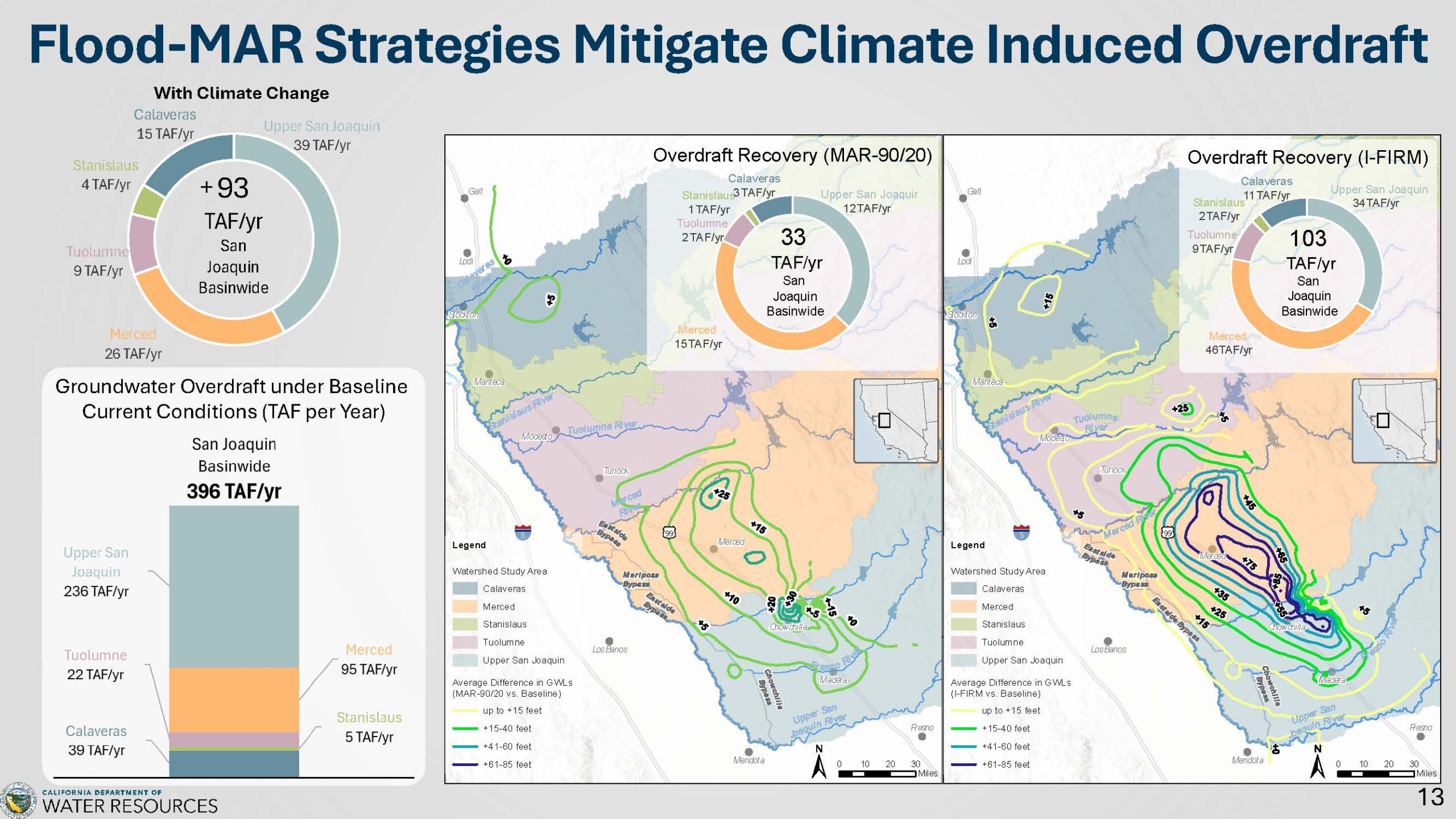
Using the MAR 90/20 strategy, about 33,000 acre-feet of overdraft can be mitigated each year. Since climate-induced overdraft is around 90,000 acre-feet, this approach addresses roughly one-third of that amount, mainly in Merced and the Upper San Joaquin, and to some extent in Calaveras. IFIRM helps retain slightly more than 100,000 acre-feet in the aquifers. This mitigates the climate-induced overdraft and reduces baseline overdraft somewhat, but doesn’t eliminate the problem entirely.
“Flood MAR alone won’t solve the overdraft problems,” said Mr. Arrate. “It’ll help mitigate climate-induced overdraft and a little bit of the baseline, but it doesn’t solve everything. We do see significant increases in groundwater levels in the Merced, Tuolumne, and upper San Joaquin watersheds, as well as in the Calaveras watershed.”
Flood risk reductions
When considering flood risk reduction, both the Tuolumne River and Upper San Joaquin River currently face issues due to limited channel capacities—approximately 9,000 CFS for the Tuolumne and 8,000 CFS for the Upper San Joaquin. In the baseline scenario, maximum simulated flows greatly exceed these limits, reaching 43,900 CFS and 36,400 CFS, respectively. Climate change is expected to push those peak flows even higher, up to 76,100 CFS for the Tuolumne River and 51,400 CFS for the Upper San Joaquin River. For the Merced River, baseline peak flow matches its channel capacity; however, climate change is expected to increase peak flows to nearly five times the channel’s design capacity during extreme events.
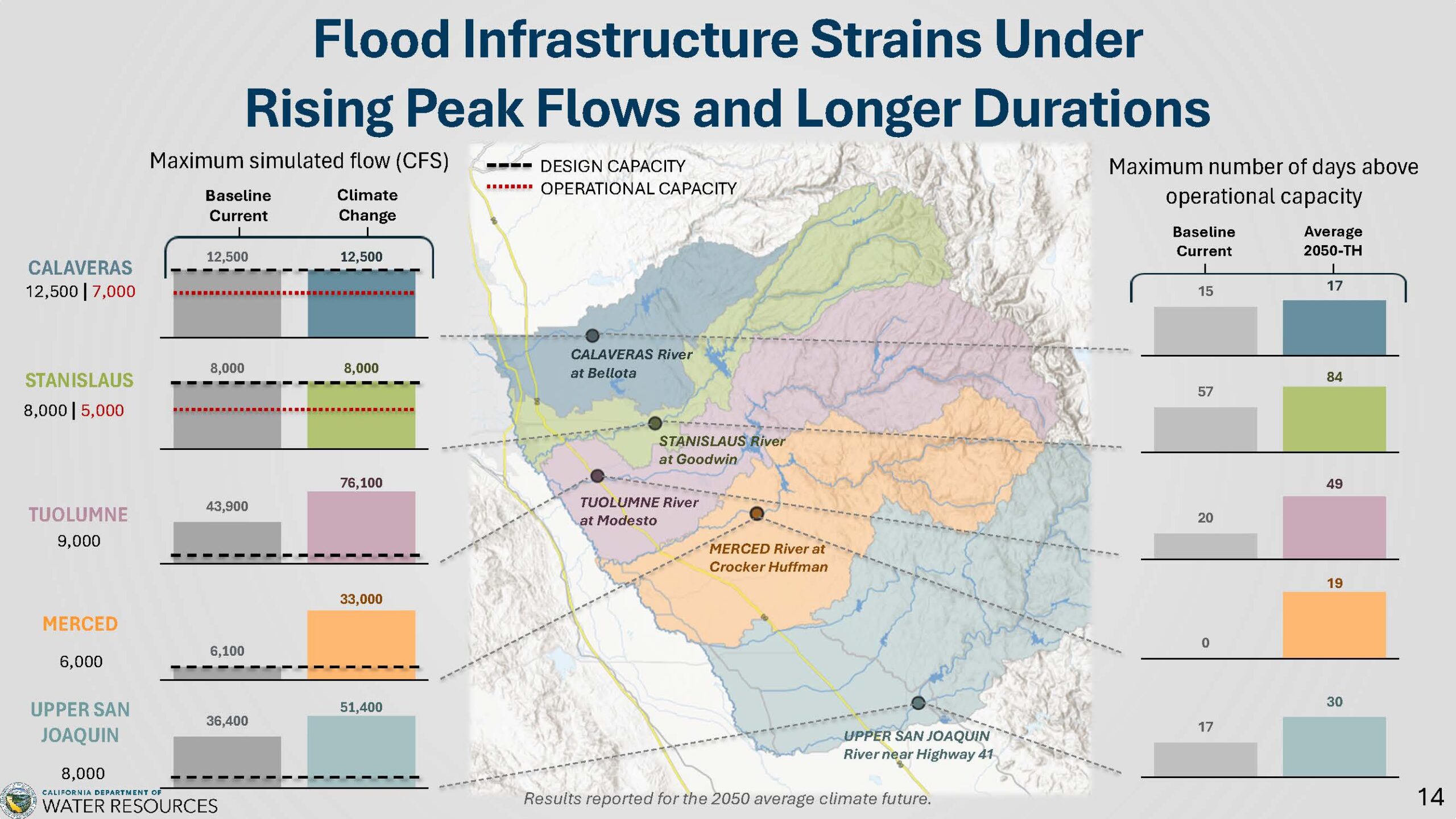
The Calaveras and Stanislaus Rivers remain at their respective channel capacities under both baseline and climate change scenarios. Nonetheless, each river faces operational capacity constraints due to erosion, seepage, and related effects. Specifically, the Stanislaus River’s operational capacity is reduced to 5,000 CFS from its designed 8,000 CFS, while the Calaveras River operates at approximately 7,000 CFS compared to its designed capacity of 12,000 CFS. Furthermore, climate change significantly raises the number of days when operational capacity is exceeded. This places greater stress on levees, extends their saturation periods, and increases the risk of erosion and breaches.
Flood MAR strategies have varying impacts depending on the approach taken. The MAR 90/20 method is primarily intended to enhance water supply and, as a result, removes only a small portion from the hydrographs. This results in a minor reduction in peak flows, offering limited flood-mitigation benefits. In comparison, the IFIRM strategy greatly lowers peak flows on the Tuolumne and Merced rivers. While flows do not return to their original design levels, the reductions are large—the Tuolumne drops by over 20,000 CFS and the Merced’s peak flows are cut by about half. The Upper San Joaquin River also sees a smaller drop in peak flows.
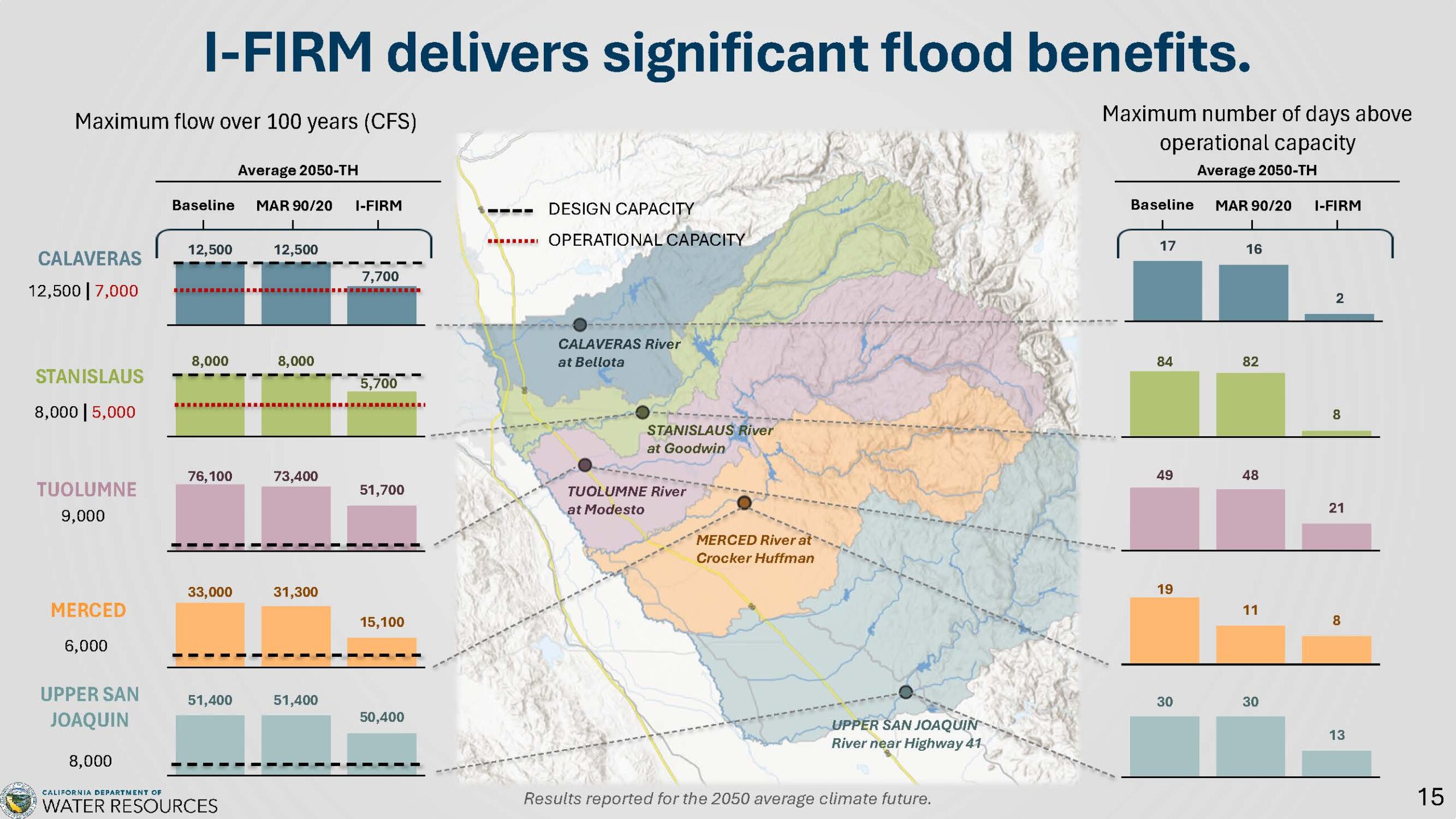
In the Calaveras and Stanislaus watersheds, IFIRM reoperation reduces peak flows to operational levels, delivering clear flood benefits by aligning flows more closely with operational standards. Additionally, with IFIRM, the frequency of days at or above operational capacity drops considerably: Calaveras goes from 17 days to just 2, Stanislaus from 84 to 8, and other watersheds see shorter periods of high-water events, meaning less prolonged stress on levees.
The study modeled 100 years of hydrology. Over that period, four flood events—1951, 1983, 1997, and 2017—exceeded the Tuolumne River’s design capacity. Climate change intensified these events, with 1997’s peak flow increasing from around 28 to over 70.
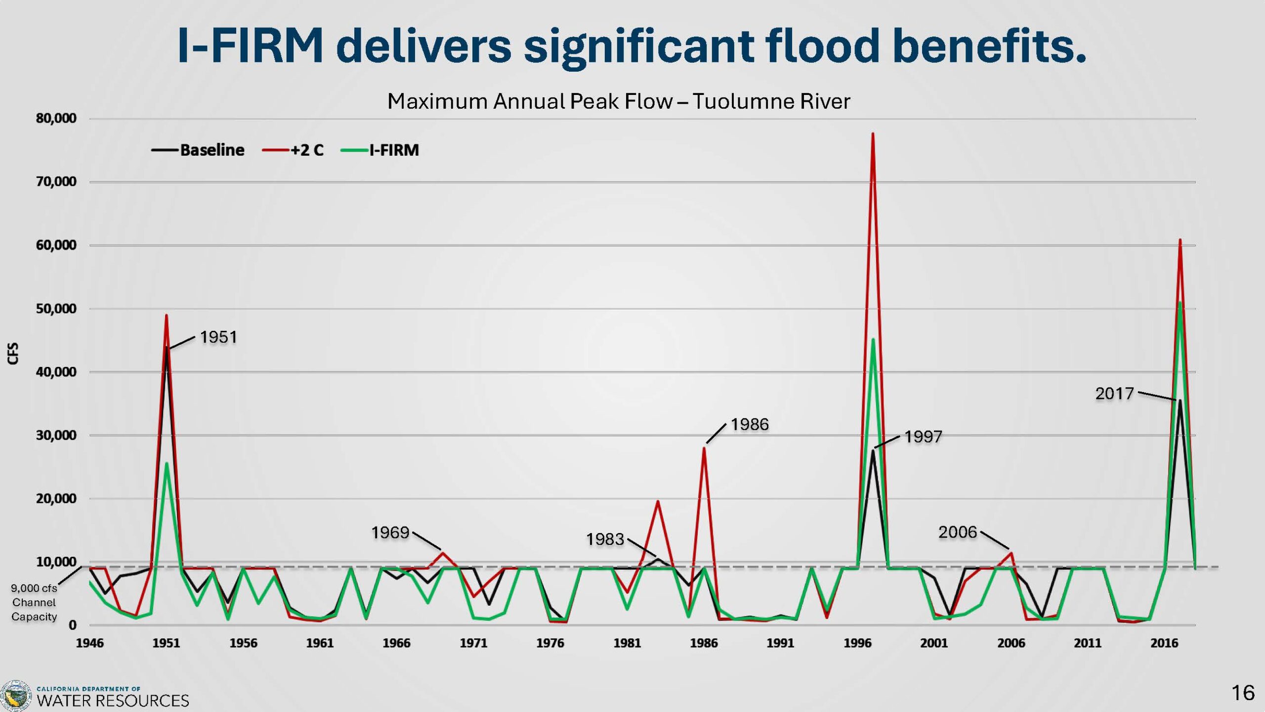
Climate change also introduced new significant floods, making 1969 and 1983 more severe and causing 1986 and 2006 to exceed capacity. IFIRM mitigated climate-induced events and reduced baseline floods: 1951 dropped from 50 to about 25, with 1997 and 2017 also showing substantial decreases. Overall, IFIRM significantly lowered flood risks in many years.
Ecosystem benefits
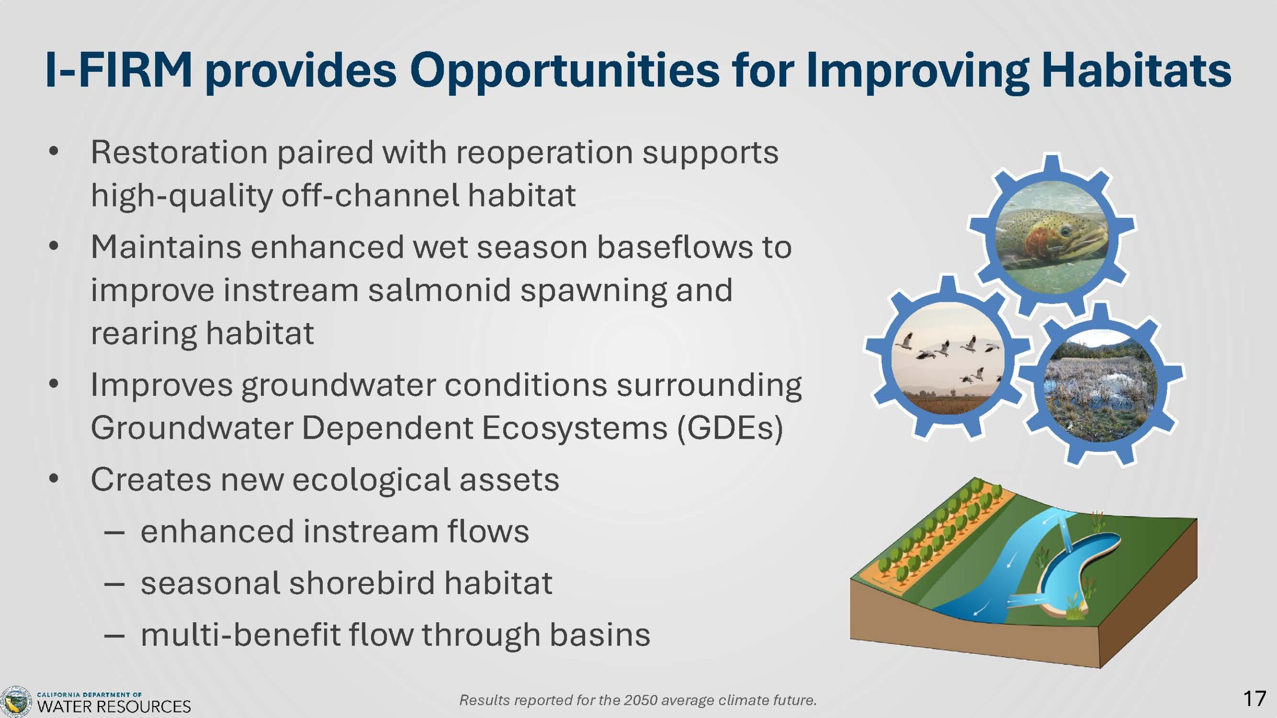 The IFIRM strategy provides multiple options to improve habitats. Restoration can be paired with stream reoperation measures—such as spring pulse or baseflow releases—to improve the quality of off-channel habitats.
Keeping wet-season base flows higher plays a key role in enhancing salmon spawning and rearing zones; this is accomplished through both changes in operations and the interconnected groundwater that feeds back into streams. When recharge activities are implemented, much of the water eventually returns, boosting base flows and supporting overall stream flow levels.
Another important approach involves multi-benefit flow-through basins, which are small, temporary storage areas found along creeks. These basins begin to fill once water reaches a certain level, providing habitat creation, flood risk mitigation, and additional groundwater recharge.
Upstream diversions don’t reduce San Joaquin River flow
Lastly, Mr. Arrate noted that upstream recharge diversions don’t translate directly to a reduction in San Joaquin River flow. “We divert water upstream, it gets recharged through the fields, and a large portion of it does come back as base flow into the streams, either later in that year or in other years,” he said. “Upstream recharge diversions at Vernalis is about 394,000 acre feet per year, but the change in flow at Vernalis itself is about 200,000 acre feet per year, so about 50% of that diversion upstream is actually showing up as a change in flow at Vernalis.”
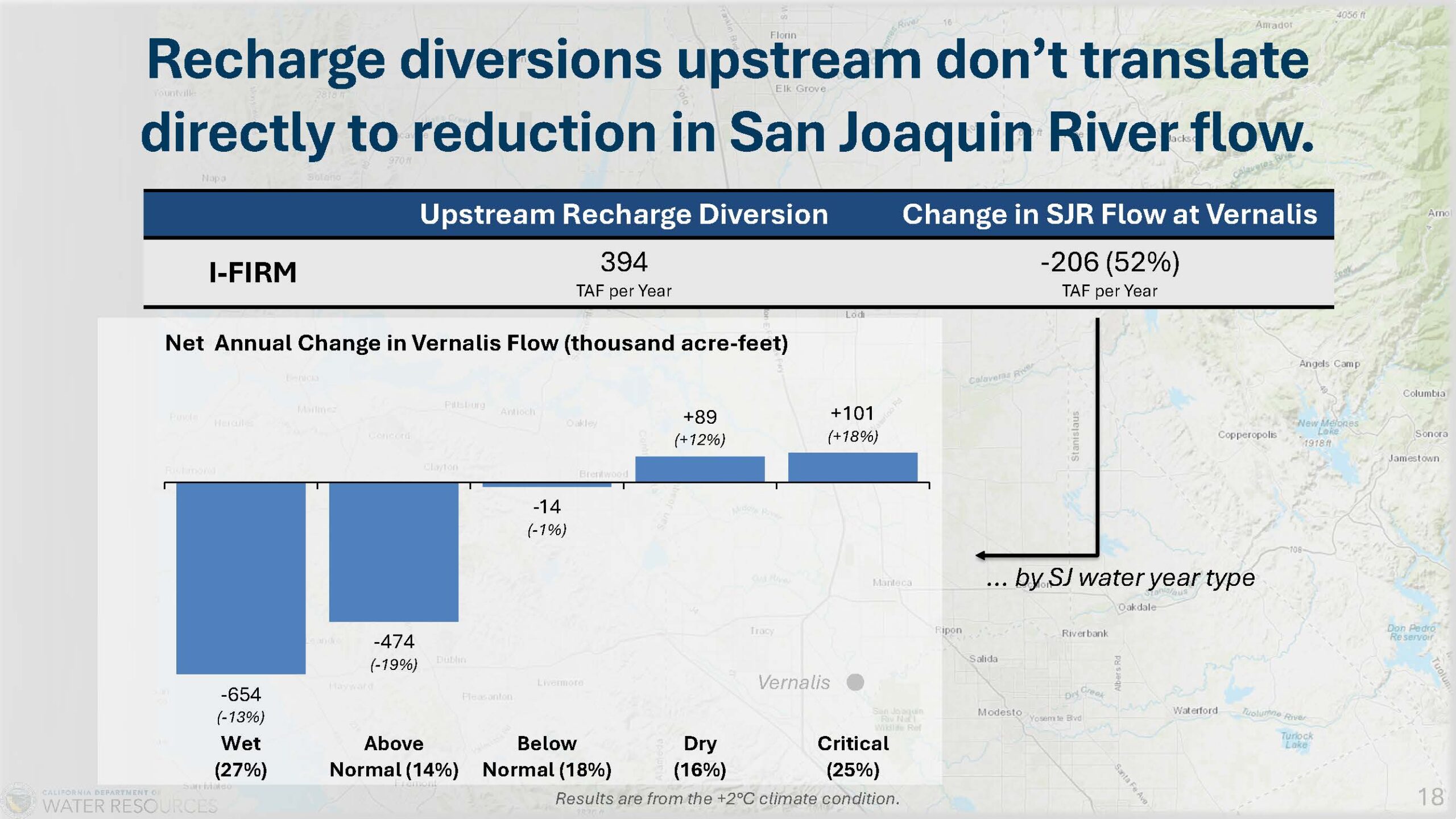
Since flood MAR is very active in wet and above-normal years, there are reductions in flow at Vernalis. “But in the drier and critical years, we do see that water increases because of that base flow returning to the tributaries in the San Joaquin River. So we do see an actual increase in flows at Vernalis due to the recharge.”
A call to action
The benefits of IFIRM are clear, but they are achievable only with coordination among multiple agencies. Flood Mar project manager Jim Wieking said the watershed studies include a call to action that will require partnerships, a pilot project, and basin-wide implementation. With both forecast-informed reservoir operations and groundwater recharge, there are opportunities for pilot projects to facilitate a learning-by-doing approach.
“We are suggesting that partnerships will be necessary to get to implementation – specifically watershed partnerships, but also issue resolution partnerships. And we’ve identified a number of issues that those issue resolution partnerships can work on, and that work should begin soon.”
To get the most benefit, IFIRM needs to be used across the whole basin. “If a single watershed implemented IFIRM, that would be great for that river, but the effect downstream, especially on the lower San Joaquin, would not get the cumulative effect,” he said.
“Similarly, the recharge implementations can be mutually beneficial across watershed boundaries. The recharge is fairly transient, so if it’s not being done in one of the watersheds, then probably they’ll receive benefits from the other watersheds. And so we think a collective basin-wide implementation for the recharge benefits will be important and beneficial.”
Next steps
The Department of Water Resources is taking a comprehensive approach to addressing the San Joaquin Valley’s challenges through three studies, all of which will form part of the San Joaquin Valley resilience strategy, set for release in early 2026. This public document will summarize the studies, assess their combined impact, and incorporate feedback into the final draft. Afterward, a San Joaquin Summit will be held in the spring to discuss the findings.
- San Joaquin Basin Flood-MAR Watershed Studies, full report
- Basinwide Summary and Next Steps
- Frequently Asked Questions
- Calaveras Watershed Study Area Report | Factsheet
- Stanislaus Watershed Study Area Report | Factsheet
- Tuolumne Watershed Study Area Report | Factsheet
- Merced Watershed Study Area Report | Factsheet
- Upper San Joaquin Watershed Study Area Report | Factsheet

