

Several news sources featured in the Daily Digest may limit the number of articles you can access without a subscription. However, gift articles and open-access links are provided when available. For more open access California water news articles, explore the main page at MavensNotebook.com.
In California water news today …
Series of storms to usher in rain, cooler air to the West
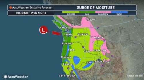 “After a notable stretch of record-breaking heat across the western U.S. through mid-march, multiple storms moving into the region will bring cooler and wet weather to end the month, AccuWeather meteorologists say. Additional daily record highs can be set on Sunday across the Southwest as the heat continues to build into the region. Daytime highs can top out from 15-25 degrees Fahrenheit above the historical average for the end of March. The first of three storms that will help put an end to the stretch of heat will impact portions of the Four Corner States through Monday as moisture drawing northward will promote spotty afternoon thunderstorms. … ” Read more from AccuWeather.
SEE ALSO: SF just broke an ‘out of the ordinary’ weather record. Now a big shift is coming, from SF Gate
California’s thin snowpack raises summer water risks
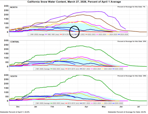
“On the eve of its critical April 1 snowpack measurement, California finds itself with a problem: too much dirt and not enough snow in its mountains. While winter storms have delivered above-average precipitation to the state, most of it fell as rain. That rain filled lakes and reservoirs, yet failed to build the snowpack California depends on to balance its water resources through the dry months. April 1 typically marks the seasonal peak, when officials measure frozen reserves to gauge how much runoff will be available after the wet season ends. “April 1 is a big day for us, it is typically when we would expect the snow melt after that,” said David Rizzardo, an engineer and hydrology manager at the California Department of Water Resources. … ” Read more from Bloomberg.
SEE ALSO: No snow. No water. Restrictions grow across West as drought fears rise, from USA Today
California’s coastal ocean is seeing a rare trend — and what happens next could be critical
“On the last day of winter, as California was in the midst of a historic early-season heat wave, the ocean off Southern California crossed a striking threshold. At Scripps Pier in La Jolla, a long-running sea surface temperature record topped out at 71 degrees, the warmest March reading in the station’s history. It was not an isolated spike. The reading broke a daily record, as had the day before. And the day before that. “The Scripps Pier sea surface temperature bucket measurements have been hitting some all-time highs for the past few months,” said Art Miller, a researcher at Scripps Institution of Oceanography who studies the dynamics of water currents. Experts like Miller say the warm ocean temperatures are part of something larger now taking shape. A strong marine heat wave has developed off the Southern California coast, and the next several weeks will determine whether it fades or deepens into something that carries real ecological and meteorological consequences into summer. … ” Read more from the San Francisco Chronicle.
High tides and hot seas: Marine heatwaves & their impacts
“When you read a tide table, it predicts tide height based on factors such as the gravitational pull from the sun and moon. What these tables don’t take into account are local factors like weather, winds, and air pressure that can also impact tides. You may have noticed the tides have been a bit higher than predicted during the last few months, which is likely due to a marine heatwave offshore of California causing warmer ocean temperatures. Experts at the National Oceanic Atmospheric Administration have been tracking a large marine heatwave off the West Coast since last May. According to NOAA, this is only the third time since 1982 that such a large part of the ocean has been warm for so long. … ” Read more from the Morro Bay National Estuary Program.
Lake Oroville is nearly full and DWR is working to hold onto every drop
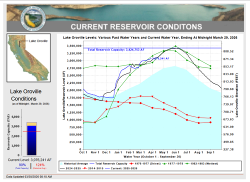 “Lake Oroville is sitting at 89 percent capacity, and the Department of Water Resources is focused on keeping it that way as dry conditions persist across the Feather River watershed. The reservoir currently stands at 875 feet in elevation. Releases to the Feather River are running at 2,100 cubic feet per second, with a planned reduction to 1,750 cfs on Sunday, March 29. Even with the reservoir nearly full, DWR is required to maintain designated flood storage space under federal guidelines set by the U.S. Army Corps of Engineers. Between mid-September and June, those rules dictate that a portion of the reservoir’s capacity must remain open to absorb potential inflows from rain and snowmelt, protecting downstream communities from flood events through carefully coordinated releases. Not all of that released water is lost. Some of it is captured downstream for use by local landowners, communities, and the State Water Project, which delivers water to roughly 27 million Californians. Releases from Oroville Dam also serve an environmental purpose, supporting Feather River habitat for salmon, steelhead, sturgeon, and other native species. … ” Read more from Active NorCal.
Tehachapi-Cummings County Water District and California DWR present details on Delta Conveyance Works project to a skeptical audience at GHCSD
“The Golden Hills Community Services District Board of Directors, along with representatives from the city of Tehachapi, Stallion Springs and Bear Valley, heard a presentation last week from the Tehachapi-Cummings County Water District and the California Department of Water Resources on the Delta Conveyance Works Project and the effects it would have on the region. The project is essentially the last piece of the California State Water Project, which brings millions of acre-feet of water from Northern California to Southern California. Delta Conveyance Works would essentially be a massive tunnel transporting water from the Sacramento River under the San Francisco Bay Delta to be returned to the system near the San Luis Reservoir. It carries a hefty price tag of $20.1 billion. … ” Read more from the Tehachapi News.
Court rejects state’s attempt to disqualify Sacramento & Stockton’s lawyers in Delta tunnel fight
“On March 27, 2026, Sacramento Superior Court Judge Stephen Acquisto denied the California Department of Water Resources’ motion to disqualify Somach Simmons & Dunn, the law firm that has represented the County of Sacramento, City of Stockton, and other local agencies in Delta Conveyance litigation since 2007. DWR’s motion, supported by some 5,000 pages of filings, argued that attorney Casey Shorrock’s prior work on a 2020 Initial Study/Mitigated Negative Declaration (IS/MND) for geotechnical investigations created a disqualifying conflict of interest. The court disagreed. … ” Continue reading at California Water Research.
Almond crops use a lot of water—this grower is changing that
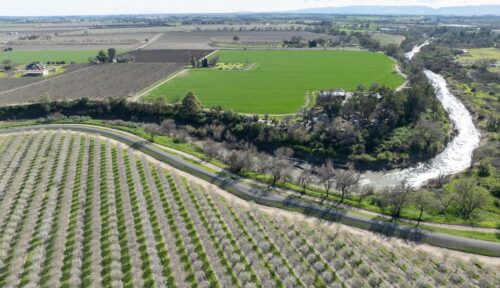
Andrew Nixon / California Department of Water Resources
“For more than a century, one family farm in California’s Sacramento Valley has quietly evolved alongside the land it stewards. Now in its fourth and fifth generations, the operation stands not only as a testament to resilience but as a leader in how almond growers are rethinking water use in a changing climate and for a crop with a water-intensive reputation. “We are proud of our heritage and stewardship of the land and of our crops,” says fifth-generation almond farmer and water conservationist Shandon Griffin Smith. Smith says that while almonds are a water-intensive crop, they’ve been shown to require less water than lettuce and walnuts when using the same water footprint measure—and they provide benefits beyond their nutritional content as well.1 Still, it’s estimated that it takes about 1 gallon of water to grow a single almond, mainly because the trees require a lot of energy to create protein. “I would ask the consumer to think about the whole tree and not just the bag of nuts in their pantry. The water used to grow nuts keeps an entire tree alive, and that lifespan is 25 years,” notes Smith. … ” Read more from Eating Well.
Life history differences between natural and hatchery-origin winter-run Chinook present opportunities and challenges for managing the endangered species
“Wild Pacific salmon and trout exhibit complex variation in completing their life cycle. Within a single population, some individuals leave their natal (birth) streams soon after they emerge from the nest to begin their seaward migrations, while others remain for several months or years before migrating downstream. During their downstream migration, areas throughout a watershed, such as tributaries, floodplains, and estuaries, can serve as habitat for juvenile salmon to rear and grow. Chinook salmon, in particular, have adaptable and variable life histories that allow them to spread out across the landscape and rear in diverse environments and at different times. This spreading of the population reduces competition in any one environment and increases population productivity and resilience to disturbance. … ” Read more from the California Water Blog.
Toxic PFAS residue identified on 37% of California produce, new analysis finds
“A first-of-its-kind analysis has identified Pfas pesticide residues on 37% of conventional California produce, with peaches, strawberries and grapes almost always found to be contaminated with the toxic “forever chemicals”. The analysis coincided with the introduction of California legislation that would by 2035 fully ban Pfas from being used as active ingredients in pesticides, and require warning labels and other restrictions in the meantime. The Environmental Working Group (EWG) non-profit conducted the analysis of California department of pesticide regulation residue testing records. It found about 90% of peaches, plums and nectarines contained Pfas residues, while 80% of strawberries and grapes showed them. Those levels are especially alarming because children commonly eat fruits like grapes and strawberries, and children are most at risk from the chemicals’ toxic effects, said Bernadette Del Chiaro, senior vice-president of EWG’s California operations. … ” Read more from The Guardian.
Intensifying drought could trigger water shortages and prolonged fire season in the West
“Several regions in the West could be facing worsening drought conditions, increased wildfire risk, and reduced water supplies due to record-breaking temperatures and minimal winter snowpack. Much of the West has been coping with prolonged drought conditions that are now being worsened by historically low seasonal snowpack and persistent record-breaking temperatures. With mountain snowpack sharply reduced, the region’s water supplies are facing mounting challenges and elevated wildfire risk is occurring earlier than usual. More than half of the West continues to experience drought conditions of varying intensity, according to the U.S. Drought Monitor. The ongoing drought was compounded by the region’s warmest winter on record, according to the National Oceanic and Atmospheric Administration (NOAA). … ” Read more from ABC News.
In regional water news and commentary today …
NORTH COAST
Ukiah Commentary: Coast water project update
Mark Scaramella writes, “The Supervisors’ recently allocated $500k of hard to come-by County funds for nebulous “water security.” Nobody will say if the money will go to attorneys, lobbyists and consultants or actual water projects. Presumably it will end up in the hands of the Inland Water and Power Commission which is trying to secure some storage for Potter Valley after PG&E abandons and decommissions their dams on the Eel River, depriving Potter Valley of their annual water diversion. Water projects in California are expensive. Some say water storage to capture some of the piped over water from the pumping facility that will replace the diversion might cost between $500 million and $1 billion. … ” Read more from the Ukiah Daily Journal.
SIERRA NEVADA
North Yuba River cleanup underway after Colgate penstock pipe rupture
“Yuba Water Agency has begun removing sediment on the riverbank below New Colgate Powerhouse following a penstock pipe rupture last month. The work started on Friday and is expected to last for several weeks, with completion targeted for June 1. Crews will remove an estimated 60,000 cubic yards of sediment that entered the North Yuba River when water from the ruptured penstock carried soil, rock, and debris down the hillside on Feb. 13. The rupture created 2 large sediment fans on either side of the powerhouse. Crews will also work to locate and safely remove any man-made debris that may be buried within the sediment. Ongoing soil sampling results have not shown concerning levels of contaminants. … ” Read more from Action News Now.
Lake Tahoe sees dramatic rise in water levels
“Lake Tahoe received a dramatic boost to its water levels this winter, as a series of powerful storms pumped roughly 16 billion gallons of water—enough to fill about 90,000 Olympic‑size swimming pools—into the lake since mid‑February, according to new data reported by SnowBrains. Figures from the U.S. Geological Survey (USGS) show that between February 15 and early March, Lake Tahoe’s water level rose from about 7.5 feet to 8 feet, a significant increase, given the lake’s enormous size. The surge has largely been driven by a series of severe winter storms and atmospheric river systems that swept across Northern California and the Sierra Nevada region in recent weeks. … ” Read more from Newsweek.
After deadly Lake Tahoe avalanche, experts warn of changing risks in the West
“Stretches of calm weather in the mountains might seem harmless, but they can quietly increase avalanche danger over time. And traveling in groups doesn’t always make skiers and snowshoers safer. That’s one of the key takeaways from experts in the Sierra Nevada, where one of the deadliest avalanches in U.S. history recently struck near Lake Tahoe. On a recent day along a snowshoe trail on Mount Rose, just outside Reno, Nevada, Wendy Antibus with the Sierra Avalanche Center checked the daily conditions. “Today, our avalanche hazard is low,” she said, noting cooler temperatures and wind had helped freeze the snow’s surface. But even on a low-risk day, she said, the snowpack can be more complicated than it appears. … ” Read more from the Tahoe Daily Tribune.
Sugar Bowl announces temporary closure before final ski weekend
“Sugar Bowl will temporarily close for three days this week to “preserve coverage” of its limited terrain, the Tahoe ski resort said Sunday. The resort previously announced it had pushed up its closing date to April 5 due to a lack of snow, but slopes will now be closed Monday through Wednesday. Keeping equipment off the mountain will “set us up to reopen for an incredible closing weekend,” Sugar Bowl said in an email Sunday morning. A storm system was forecast to move through the Lake Tahoe area this week, though it was trending weaker and warmer. … ” Read more from the San Francisco Chronicle.
Forest Service releases final Caldor Fire restoration notice
“The newly released final environmental assessment and decision notice for the Caldor Fire Restoration Project offers restoration details for the roughly 11,700 acres of national forest lands in and around the Caldor Fire area in the Lake Tahoe Basin. The Caldor Fire burned 346 square miles between Aug. 14 and Oct. 21, 2021, forcing the evacuation of South Lake Tahoe and the first mandatory evacuation in history issued for Douglas County’s communities at Lake Tahoe. It began just as firefighters were containing the 107-square-mile Tamarack Fire, which burned through Alpine County and over the mountains into southern Douglas County. “This decision will guide active forest management activities that will help accelerate post-fire recovery and enhance community protection,” said Deputy Forest Supervisor, Rosalie Herrera on the Lake Tahoe Basin Management Unit. “Proposed restoration measures are designed to restore meadows and streams, improve wildlife habitat, and reduce hazardous fuel loads in areas affected by the Caldor Fire.” … ” Read more from the Record-Courier.
NAPA/SONOMA
Sonoma County park receives $1.5m grant for salmon habitat restoration
“Sonoma County Regional Parks has received a $1.5 million state grant to restore wetlands, streams and fish habitat at Mark West Creek Regional Park and Open Space Preserve, county officials announced. The funding from the California Wildlife Conservation Board will support a three-year project aimed at improving habitat for coho salmon and steelhead trout in a key tributary of the Russian River watershed, according to a press release issued Friday. Regional Parks is partnering with the Sonoma Resource Conservation District and Trout Unlimited on the work, which is expected to begin later this year. … ” Read more from SF Gate.
BAY AREA
They want to open 700,000 acres to drilling — including land near Mount Diablo
“Under the Trump administration, sections of Mount Diablo and other natural habitats in the Bay Area are now under threat from oil and gas drilling, something advocates worry will disrupt habitats, beloved recreational areas and public health. Conservation nonprofit Save Mount Diablo and other groups are ringing the alarm on efforts to open about 700,000 acres of land to oil and gas leasing. It’s a plan the Bureau of Land Management says aligns with President Donald Trump’s “Unleashing American Energy” initiative. Countless people visit the 20,000 acres that make up Mount Diablo State Park and all the other federally, state and locally managed open lands across the range, each home to a variety of animals and plant species. … ” Read more from the San Jose Mercury News.
Bay Area weather radar network aims to improve storm forecasting, flood prep and drought planning
“Local, state and federal agencies gathered in San Francisco Thursday to announce a new radar network designed to show where the heaviest rain will fall in the Bay Area. The San Francisco Public Utilities Commission worked with a coalition of Bay Area water, wastewater and flood control agencies on the project. The network can help with evacuation plans or water resource planning in our drought-prone state. Martin Ralph, Ph.D., of UCSD Scripps Institution of Oceanography, said the existing traditional radar network doesn’t cut it. “This is going to help fill that gap in minutes to hours lead time that’s vital to know where the heaviest rain is going to hit,” Ralph said. “And when and what communities are going to be affected so people in the preparedness community and water resource management community can take action to help protect people’s lives and property.” … ” Read more from ABC 7.
Ross Valley flood board backs cancellation of bridge project
“The Ross Valley flood board is urging county supervisors to cancel a plan to remove Building Bridge 2, the century-old structure in San Anselmo. The Flood Zone 9 Advisory Board voted 4-1 on Thursday to endorse the recommendation of the county public works director, Christopher Blunk, to abandon the project. Blunk, who has been director for about 15 months, apologized to residents who have criticized how the county and the Federal Emergency Management Agency have handled the 15-year project to lessen flood impacts in the watershed. “This is not a good news story, not something to celebrate,” Blunk said. “Our recommendation, after our evaluation, is that this is a time for us to stop while we still have some resources and hope to see what we might be able to do.” … ” Read more from the Marin Independent Journal.
SAN JOAQUIN VALLEY
Manteca moving toward web-based water metering
“Manteca is making it possible for customers to eventually monitor water use on an hourly basis using an app on their smartphone or a webpage. It is part of an ongoing water meter replacement program that started three years ago. The City Council approved funding for another 3,000 replacement meters earlier this month. When all the water meters are replaced, it will eliminate the need for two city water meters that represents an annual cost of $120,000 plus in salaries and benefits alone. Besides saving money over time, the new meters allow for the city to comply with state mandates for data to confirm jurisdictions are aggressively working to reduce per capita water compensation. … ” Read more from the Manteca Bulletin.
Arvin, Veolia unveil solar project to power wastewater treatment plant
“The City of Arvin, California, and Veolia recently unveiled a new solar energy installation that will power the city’s wastewater treatment plant, eliminating greenhouse gas emissions and providing financial and environmental benefits to the community. The 1-megawatt solar array at the City of Arvin, which serves nearly 21,000 residents, is projected to eliminate 360 metric tons of carbon dioxide emissions annually — equivalent to taking 80 cars off the road, according to a press release from Veolia. Over 30 years, the project is expected to save Arvin taxpayers more than $17 million, making it a model for sustainable infrastructure investment. The energy generated will provide approximately 90% of the wastewater plants’ annual needs. … ” Read more from Water Finance & Management.
SOUTHERN CALIFORNIA
What’s in dirt? UCLA scientists testing soil in fire zones for lead, offer inexpensive fixes
“Dirt. It surrounds people’s homes. It’s in local parks, schoolyards and parkways abutting sidewalks. But it’s not something people paid much attention to. Until recently. Ever since the Palisades and Eaton fires in January 2025 burned out more than 16,000 structures, mostly homes, leaving piles of charred rubble behind often with lead-contaminated ash, dirt has become big news. Once this debris was removed and sent to landfills, the focus shifted downward to the lot’s remaining dirt. People asked: Is it safe? Many fire survivors, both those with cleared lots, and displaced survivors with standing homes infiltrated by smoke and ash, say the government has not supplied clear answers to that question. And insurance companies have not provided the money for remediation of dirt laced with high amounts of lead that tests above state safety levels and in some cases, higher than the more lenient federal standard. … ” Read more from the LA Daily News.
Ocean heatwave is great for SoCal surfers and fishing fans — but not for some sea creatures, or the weather
“Doug Hibbard noticed something odd for this time of year at San Onofre State Beach: A surfer riding waves without a winter wetsuit, instead sporting just swim trunks. “Really? In March?” The Laguna Niguel surfer who has been catching waves for nearly six decades wasn’t totally surprised; he, too, has noticed this winter that the water feels more like a lukewarm bath than the toe-numbing, frigid cold plunge typical for this time of year. “The water never got cold,” Hibbard, 69, said of this winter season. “I don’t think it ever dropped below 60.” Marine scientists, researchers and the fishing community are also buzzing about yet another marine heatwave some are saying could rival “The Blob” from a decade ago that had big impacts on the coast. … ” Read more from the OC Register.
He swapped his lawn for native plants after asking, ‘What was meant to be here?
“When Christopher Smee welcomes visitors to his Glendale garden, he enjoys giving what his friends jokingly call “the botanical tour.” “Would you like to walk through the native chaparral?” he asks, pointing out the California native plants in his front yard: a multi-trunk toyon, bright orange California poppies (Eschscholzia californica), lantern-shaped Bladderpod (Cleomella arborea) with yellow flowers that bloom most of the year, purple Arroyo lupines (Lupinus succulentus), fragrant Allen Chickering Sage (Salvia ‘Allen Chickering’), and tall, silvery white sage (Salvia apiana) at the center. “I love the majesty and structure of the white sage,” he says, pointing out the dried branches he leaves for the birds. “I love the color, and when I learned about its importance to the Indigenous community, I felt it should be at the center of the garden.” … ” Read more from the LA Times.
SAN DIEGO
Officials extend beach closure in Coronado amid sewage contamination
“San Diego County health officials have announced a beach closure in Coronado due to sewage contamination. The water contact closure in place for the Tijuana Slough, Imperial Beach, Silver Strand, and the shoreline from north of Avenida Lunar to North Beach Coronado is being extended to include the beach at Avenida Lunar, according to the San Diego County Department of Environmental Health and Quality. “The Tijuana River is flowing and reaching recreational waters. Beachgoers are advised that the ocean water contains sewage and may cause illness,” the DEHQ said in a statement Saturday. “Ocean waters will remain closed until sampling and field observations confirm these areas are safe for water contact.” … ” Read more from the Times of San Diego.
Along the Colorado River …
Colorado River commissioner gives fiery speech on river negotiations at Southwest Colorado seminar
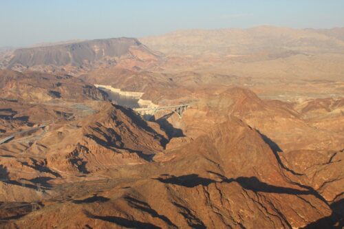 “Wildfire threats became a tired talking point at this year’s Southwestern Water Conservation District seminar in Ignacio on Friday, but attention spiked during a fiery speech by Colorado River Commissioner Becky Mitchell. Contentious negotiations for water cuts between the seven states that rely on the shrinking Colorado River are in a deadlock. “I want to talk a little bit about the post 2026 negotiations. I know that’s why I get invited,” said Mitchell, who represents Colorado in the upper basin coalition, to an audience of more than 200 at the Sky Ute Casino Resort. “Hopefully, someday, I won’t be as popular.” … Despite the crisis, deadlines for establishing new agreements before federal government intervention continue to be surpassed, with water cuts remaining the source of contention. Upper basin states argue they have long conserved water and advocate shifting cuts onto lower basin states, which object. “The pain that is caused within this state on the hydrology of this year now – cutting below that? Cutting beyond that? You’ve got to be kidding me,” Mitchell said. “It feels like it’s about inflicting pain on where pain is already being inflicted.” … ” Read more from The Journal.
Colorado River stakeholders leave thousands of comments on federal water plan
“The Bureau of Reclamation has been flooded with comments on its plan for dividing the Colorado River’s dwindling supply of water — over 18,000 from the states, cities, tribal nations, industry groups and others that rely on it. Few are happy about the plan. Most are very unhappy. “The Colorado River reservoir system cannot be stabilized simply by reallocating scarcity,” The Nature Conservancy, Environmental Defense Fund and other groups wrote in one comment, criticizing the plan for focusing on emergency measures rather than conservation and planning. Arizona and six other states that rely on the river missed deadlines in November and February to find agreement on their own. … ” Read more from KJZZ.
As the West’s scant snowpack melts, Coloradans brace for a lean water year
“Call it the winter that wasn’t. Throughout Colorado a record-warm and dry winter has come to a close. Attention now pivots to spring and the potential for additional snow to allay increasing drought concerns. Though, there appears to be little relief in sight. The Denver-metro area went months without measurable snowfall this winter. The city’s daytime temperatures often surpassed 60 degrees. Hikers and trail runners rejoiced over the warm weather while grumbling skiers lamented their underused season passes. In the state’s Rocky Mountains snow accumulation was sluggish, as warmer than normal temperatures led to midseason snowmelt, and caused more precipitation to fall as rain instead of snow. A persistent mid-March heatwave kicked off rapid snowmelt. Colorado’s snowpack, and in the broader Colorado River basin, set new record lows throughout winter. T-shirt weather wasn’t just confined to lower elevations either. The high country too experienced balmy days and nights. … ” Read more from the Circle of Blue.
In national water news today …
Scientists solved the mystery of missing ocean plastic—and the answer is alarming
“Scientists have uncovered something surprising in the Atlantic Ocean. The majority of plastic pollution may no longer be visible at all. Instead, it exists as nanoplastics, particles so small they are measured in billionths of a meter. “This estimate shows that there is more plastic in the form of nanoparticles floating in this part of the ocean than there is in larger micro- or macroplastics floating in the Atlantic or even all the world’s oceans!” said Helge Niemann, researcher at NIOZ and professor of geochemistry at Utrecht University. In mid-June, he received a 3.5 million euro grant to further investigate nanoplastics and what ultimately happens to them. … ” Read more from Science Daily.

