
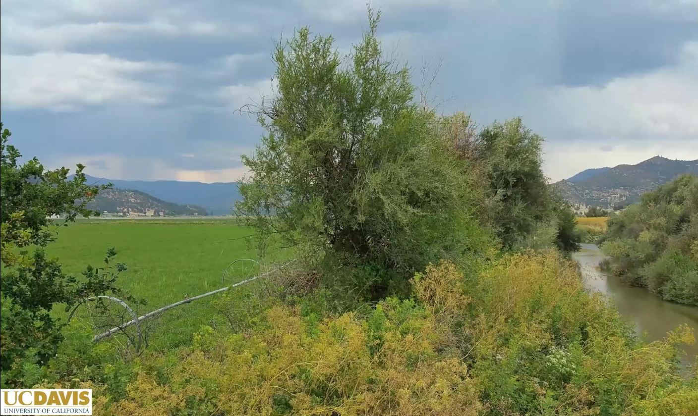
In December 2025, the Groundwater Resources Association of California hosted a two-day webinar on Interconnected Surface Water (ISW) and groundwater. ISW connects surface water bodies, such as rivers and streams, with groundwater beneath them. Pumping groundwater near these sources lowers the water table, causing surface water to seep downward and depleting streams. This interaction has significant effects on ecosystems and water resource management.
The webinar included expert presentations. Dr. Vivek Bedekar gave an overview of ISW depletion and management needs. Dr. Nicholas Murphy discussed groundwater-dependent ecosystems and their role in sustainability planning. In this third article, Dr. Thomas Harter applies these concepts to the Scott Valley and explores its groundwater sustainability plan for ISW management.
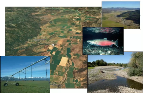 Nestled in a small alluvial basin surrounded by mountain ranges that soar up to 8,000 feet in western Siskiyou County, the Scott Valley supports approximately 30,000 acres of irrigated agriculture, primarily alfalfa and pasture. The Scott River, fed by multiple tributaries, flows through the valley from its southern end to the northwest, eventually joining the Klamath River. This river system is home to both chinook and coho salmon.
The valley’s groundwater levels have stayed stable for 20 years. However, seasonal fluctuations and agricultural demands bring challenges. One major issue is the seasonal drop in groundwater levels, which threatens late-summer streamflows vital for salmon.
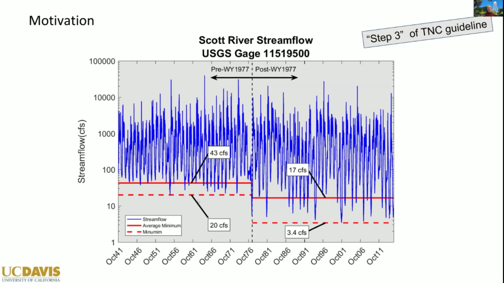
The graphic above illustrates streamflow patterns in the Scott River from the 1940s through the 2010s, showing no significant long-term trends in overall streamflows, although climate impacts have influenced certain periods in the 21st century. However, a notable shift in summer flows occurred around the 1970s, coinciding with a transition from flood irrigation to sprinkler irrigation. This change also marked a shift from surface water use to increased reliance on groundwater. The adoption of sprinkler irrigation enabled practices such as a third cutting of alfalfa, with irrigation extending into late July and August—something previously unfeasible. The additional evapotranspiration (ET) required for this third cutting is roughly equivalent to the observed reduction in summer flows in the Scott River.
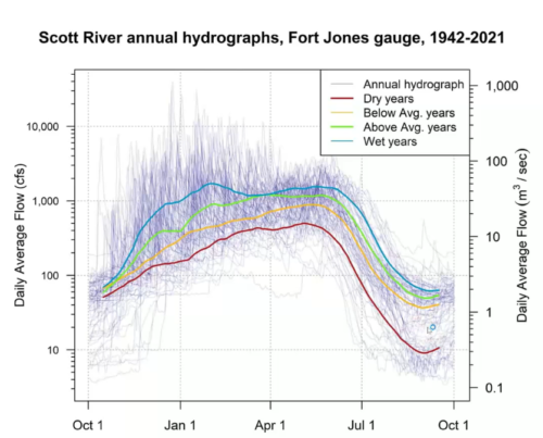 As the Scott River is undammed, its flow patterns remain highly variable. Winter flows consistently exceed 1,000 cubic feet per second (CFS), with peak flows surpassing 10,000 CFS. In contrast, summer flows drop significantly, often reaching levels as low as 10, 20, or 30 CFS.
The central challenge with interconnected surface water is assessing how groundwater pumping affects stream flow and groundwater-dependent ecosystems (GDEs). Unlike other sustainability indicators—such as declining groundwater levels leading to dry wells or land subsidence—the connection between GDEs and hydrology is complex, indirect, and difficult to quantify.
A paper by Claire Kouba, A Watershed-Specific Approach to Identify Key Functional Flow Metrics Supporting Salmon Reproduction, looks at fish rearing success in the Scott Valley. “She tried to relate that to hydrology,” said Dr. Harter. “There is a significant correlation between hydrology and rearing success, but it’s not a perfect correlation, so that’s something to keep in mind when we’re looking at these beneficial uses. The hydrology is only part of what makes these fish tick.”
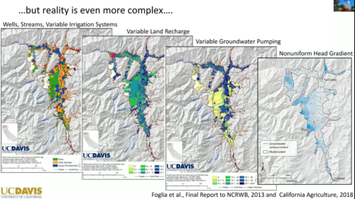 Groundwater pumping is not the only thing impacting potential stream depletion. There are surface water users, groundwater users, and a complex relationship between the landscape and the river. There is distributed groundwater pumping, highly variable recharge, and variable irrigation. “That creates a very variable water level map for this valley, very complex and not amenable to a simple analysis of stream flow depletion,” said Dr. Harter.
Furthermore, the area along the river is adjudicated, so those groundwater pumpers are not part of the GSA. While that might seem unusual, Dr. Harter said it’s no different than having another GSA in the basin, but it makes assessing an individual groundwater pumper’s contribution to streamflow depletion challenging. Stream depletion also occurs with surface water diversions, so considering surface water rights is important when considering the contributions of surface water users to stream depletion.
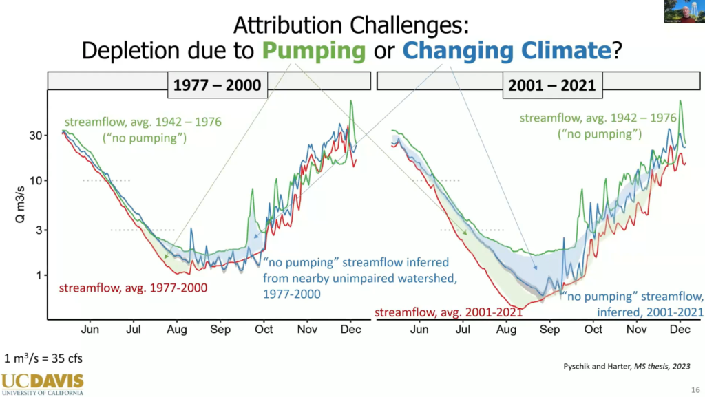
“Climate change in this system has led to significant depletion, especially in the late fall period, especially in the last 20 years,” he said. “But there is also significant depletion that we can show, even just statistically, without any other models, that’s clearly due to the groundwater pumping in that basin.”
Another task is to determine which potentially undesirable results were already present before 2015 and which emerged after 2015, so the use of a model is really important. On top of that, there is a temperature TMDL (Total Maximum Daily Load—a regulatory term describing the maximum amount of a pollutant, like heat, that a body of water can receive while still meeting water quality standards) driven by groundwater discharges to surface water.
Since 2018, due to court decisions, the public trust doctrine applies not only to surface water diverters that affect ecosystems in navigable waters, but also to groundwater users that affect navigable waters with endangered or threatened species. The public trust doctrine requires considering the public trust holistically, without the 2015 deadline for impacts under SGMA.
Ultimately, developing an accurate model is central for effectively integrating data, addressing regulatory requirements, and supporting decisions about the interconnected surface water system.
Dr. Harter pointed out that the model is firmly based on many measurements. “We have water level measurements. We have climate, streamflow, and ecosystem data. We have knowledge of the soil and the landscape. We have hydrogeologic knowledge. We have information about tributary inflow to this basin. All of this real data goes into this model in a physically consistent manner that represents our understanding of stream flow, our understanding of what happens in soils, and our understanding of how groundwater flow occurs, and what that connection is physically between the groundwater and surface water.”
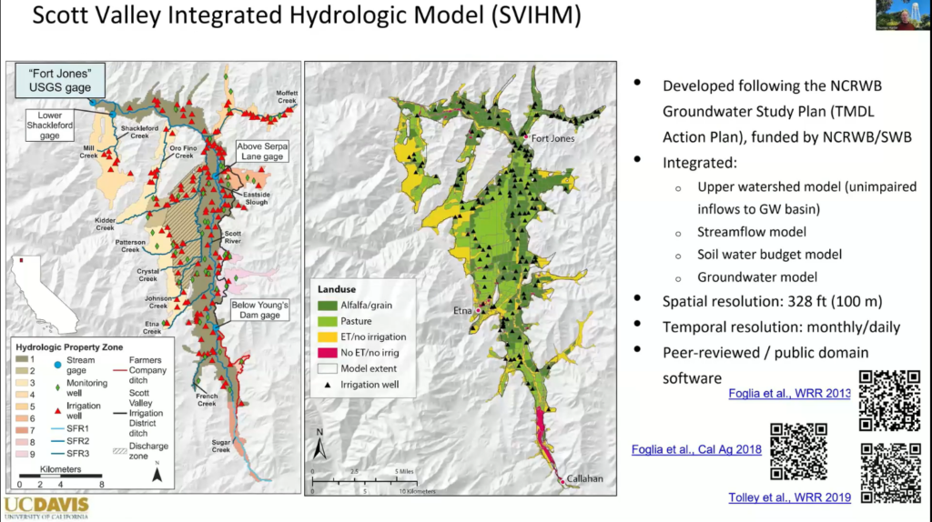
The model is an integrated representation of all the measurements and is used to predict water levels and stream flows. One of the things these integrated models are specifically designed to examine is interconnected surface water; they are very detailed in what they can simulate about streamflows as it connects to groundwater.
Local and downstream stakeholders helped develop the model. Their feedback revealed errors, prompting research on evapotranspiration, groundwater pumping, irrigation water use, and soil moisture. “This improved the model, so we now have a model that not only predicts stream flow at the outlet of the valley, but also basin-wide stream flow and water levels,” said Dr. Harter. “The model also does a fairly good job at predicting where and when streams go dry and when they’re wet.”
The model produces vast amounts of data, prompting researchers to consult stakeholders to determine which aspects are most important to examine. Stakeholders then helped identify key metrics to assess potential impacts on beneficial uses.
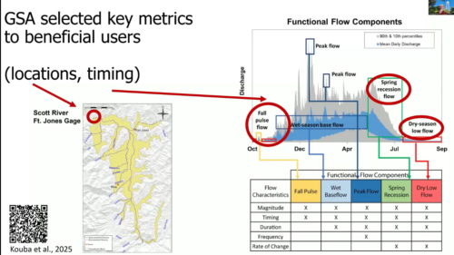 Stakeholders were particularly interested in understanding flow dynamics at the Fort Jones gauge, which provides a long-term record spanning 80-90 years. They wanted to know the extent of stream depletion at this location and to explore possible measures to improve flows—especially during fall pulse flows, dry-season low flows, and spring recession flows, which are vital for the basin’s fish populations.
The next step is to quantify the depletion using a two-step modeling process. First, a base model simulates historic conditions. Then, an identical model is run without groundwater pumping. By comparing the resulting flow time series at the gage, the difference shows the amount of streamflow depletion.
But it isn’t that easy, said Dr. Harter. “This is not just about turning off the pumping. In the model, turning off the pumping means there would be changes in the landscape in the long term. There would be changes in the landscape and changes in vegetation. There might be different land use. There might be natural vegetation. There might be something else that might be tied in, maybe with a surface water distribution system. Maybe there is no irrigation at all. These things need to be considered and designed with the no-pumping scenario.”
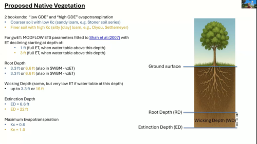 To determine the likely natural vegetation, the researchers consulted mid-1800s literature that identified bunch grasses and clover as dominant species. They mapped the potential distribution of bunch grasses and calculated root depth and extinction depth for the specific soil types present in Scott Valley.
“We designed our model to be capable of simulating that vegetation in the groundwater uptake that would be there in lieu of agriculture, because we want to account for the fact that even under a no-pumping scenario, there might be vegetation that would potentially take up groundwater if the water table was shallow enough,” said Dr. Harter.
Spatial distribution also plays a critical role. Both the GSA area and the adjudicated zone must be considered when evaluating the no-pumping scenario.
“Then we get to the depletion, and we can now look at how to design this minimum threshold,” said Dr. Harter. “If we just look at the 2015 deadline, that’s one thing, but we actually have the public trust doctrine, which requires us to have less stream depletion. So we’re going to reverse stream depletion with projects and management actions, and we’re going to set a minimum threshold that is higher than what we’re currently experiencing in terms of that stream depletion reversal, which is zero. So we want to have a higher stream depletion reversal, and that needs to be tied to projects and management actions.”
Economics factors are also considered, so cost is also a consideration. “That consideration led the Local Advisory Committee that developed the groundwater sustainability plan to identify enhanced aquifer recharge as the most desirable tool to reverse some of that stream flow depletion, and we set the minimum threshold for that reversal at 19% of current depletion. So that actually speaks not only to the SGMA, but also to the public trust doctrine.”
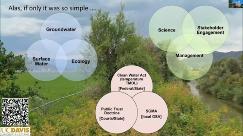 The Scott Valley groundwater sustainability plan was approved in 2023 with some recommendations from DWR for the next update.
“Of course, things are never quite as easy,” said Dr. Harter. “We now have a separate process in place where the State Water Board, through its drought emergency order, and now with AB 263, sets minimum instream flow guidelines, and is curtailing not only surface water users, but also groundwater users in this basin. And in the long run, the emergency order, AB 263, and the instream flow requirements will have to be integrated into the groundwater sustainability plan. With that, we’re not getting out of jail for free.”
- Part 1: Unraveling the dynamics of interconnected surface water depletion, by Dr. Vivek Bedekar
- Part 2: Interconnected surface water (ISW) management considerations for groundwater-dependent ecosystems – tools and approaches, by Dr. Nicholas Murphy
- Part 3: Developing a GSP to manage interconnected surface water: A case study, by Thomas Harter
- Part 4: Untangling ISW Depletion: What DWR’s Upcoming Guidance Means for GSAs, by DWR’s Craig Altare
- Video, day 1
- Video, day 2

