

A network of year-round observing stations help meteorologists forecast extreme rainfall events
From NOAA Research
As the western United States heads into its traditional dry season, water managers are assessing how winter rains have helped replenish the region’s reservoirs. The vast majority of precipitation that falls during the wet season results from atmospheric rivers (ARs) that rain down life-sustaining water but can also cause costly destruction. These fast-moving “rivers” of water vapor in the sky supply up to half of the region’s annual precipitation, with stronger ARs responsible for the majority of flood damages along the West Coast.
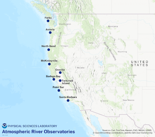
To aid in predicting and monitoring these extreme weather events, NOAA Physical Sciences Laboratory (PSL) operates nine atmospheric river observatories at sites distributed along the coast from Washington to Southern California. These unmanned weather stations send round-the-clock observations back to the laboratory, which analyzes and displays the data publicly on its Atmospheric River Portal. The National Weather Service utilizes this data portal to produce forecasts and weather warnings. State and local agencies also use the portal for creating water management strategies and emergency response planning.
A “picket fence” along the coast
Atmospheric rivers are long currents of water vapor that form in the tropics over the open ocean and are carried to higher latitudes by strong winds. NOAA satellites are best suited to monitor these storms, which are categorized on a scale similar to hurricanes or tornadoes, before they make landfall; but once an AR arrives at our doorstep, satellites fail to adequately capture its complex interaction with the mountainous terrain of the West Coast.
“While satellites can observe the winds at the top of an atmospheric river’s clouds, they cannot see inside where the wind and moisture determine how hard it will rain or where the AR will make landfall.” said Rob Cifelli, recently retired radar meteorologist, who also served as the lead precipitation and AR scientist at the NOAA Physical Sciences Laboratory.
This observational gap led PSL researchers to develop the plan for a “picket fence” of ground-based observatories along the coast. PSL installed seven coastal and two inland stations between 2013 and 2017 with funding from the California Department of Water Resources and the U.S. Department of Energy. PSL has continuously maintained and improved the network of atmospheric river observatory (ARO) stations in the years since.
“The AROs provide NOAA researchers and the scientific community with data from within ARs that instruments like the satellites and traditional weather radars cannot,” Cifelli added. “This allows us to study the internal structure, improve our understanding of how ARs behave, and evaluate existing model forecasts to improve our predictions of the intensity, duration, and location of these storms. Better forecasts lead to better flood preparedness and water management in the affected areas.”
In total, the ARO network comprises over 100 sensors and instruments that monitor key environmental variables including water vapor concentration, wind speed and direction, freezing elevation and soil moisture. These instruments include compact wind profilers that use technology invented and assembled by PSL engineers.
The nine AROs complement other methods used by NOAA and partners to monitor ARs and to paint a clearer picture of real-time conditions across the wide region. Other monitoring methods include satellites, aircraft reconnaissance missions and additional land-based observations. This information can be accessed through an Atmospheric River Portal hosted by PSL, which offers visualizations of current conditions as well as computer model forecasts of future AR conditions.
Serving up critical data, rain or shine
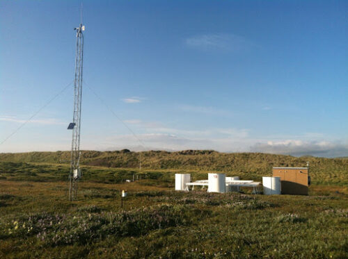
PSL’s ongoing support of the ARO network remains a central part of the lab’s mission to advance the prediction of water availability and extremes. While the West Coast gets a break from atmospheric rivers during the summer months, PSL engineers and field scientists will be busy doing maintenance on the observatories in preparation for the next rainy season. As Jennifer Bednar, the lead of PSL’s Data, Instrumentation, and Field Campaigns Division, explained, “The dry season gives our small team a critical window of time to keep our ARO network intact to ensure the National Weather Service and others continue to benefit from the over 21 million observations the network produces annually.” Furthermore, the AROs serve a complementary role in the summer months to monitor soil moisture and drought conditions in support of the National Integrated Drought Information System.
In addition to the nine dedicated atmospheric river observatories, there are 48 other sites throughout California, Oregon, and Washington that contribute to atmospheric river observations and are maintained by PSL engineers. This observational data is made publicly available to be used by others in addition to NOAA to serve applications including emergency preparedness, wastewater system management, reservoir operations, and more.
To explore the data yourself, visit the PSL Observation Network.
For more stories on atmospheric rivers …
THE CONVERSATION: How heat on the Tibetan Plateau fuels powerful storms in California, half a world away
By Yongkang Xue, University of California, Los Angeles The Tibetan Plateau may be on the other side of the world from California, but what happens on this high-altitude landscape in Asia can set off a chain of events that fuels powerful atmospheric rivers with flooding rainfall and heavy snow hitting the U.S. West Coast. My team of atmospheric scientists discovered this connection, and we explain how it works in a new study in the journal Science Advances. California’s unexpected rainfall […]

SCRIPPS: How does El Niño impact the weather?
Scripps Oceanography meteorologists and climate scientists answer questions about El Nino’s impact on weather By Lauren Fimbres Wood, Scripps Institution of Oceanography The Pacific Ocean’s El Nino-Southern Oscillation (ENSO) occurs irregularly but can have major impacts on global temperature, weather patterns, coastal hazards, and marine ecosystems. While El Niño has often been associated with increased precipitation and La Niña with drier years, recent research from Scripps Institution of Oceanography at the University of California San Diego shows that is not always […]
SCRIPPS: Study: Reservoir management system could save California $150 Million every year
Improved weather forecasts can maximize reservoir efficiency, saving between 100-160 billion gallons of water annually By Scripps Institution of Oceanography Key takeaways A reservoir management program administered by UC San Diego’s Scripps Institution of Oceanography with state and federal agencies could save an estimated 100-160 billion gallons a year, enough for more than a million households. The program, called Forecast-Informed Reservoir Operations (FIRO), can help California reach a goal of making nine million acre-feet (2.9 trillion gallons) of additional water supply available […]
NASA data feeds river forecasts as snow drought effects linger
By Emily DeMarco, NASA As the effects of the 2026 snow drought in the western United States carry into summer, NASA Earth data is feeding machine-learning forecasts that inform decisions about water, power, and public safety in Washington state. Tacoma Power, a Washington public utility, is using a U.S. technology company’s river-flow forecasts during a year of water extremes on the Cowlitz River. The utility’s largest hydroelectric project uses water stored behind Mayfield and Mossyrock dams to generate enough electricity […]
UC RIVERSIDE: Slowing Atlantic current fueling stronger California storms
Study shows how ocean circulation will reshape global rainfall By Jules Bernstein, UC Riverside A slowing Atlantic Ocean current is projected to intensify powerful storms in California while reducing snowfall over Greenland, according to a new University of California, Riverside study. The Atlantic Meridional Overturning Circulation, or AMOC, works like a giant conveyor belt in the ocean, moving warm water from the tropics northward to heat places like Europe, then cycling the cooled, denser water back south along the ocean […]
Click here for the archive of articles on atmospheric rivers.
