
Coastal communities, particularly those around large estuaries like San Francisco Bay, face increasing challenges due to sea-level rise and anthropogenic activities such as sediment extraction. Understanding the potential effects of these perturbations, particularly in the face of accelerating sea level rise, requires a better understanding of estuaries’ sediment sources and transport pathways.

A new study conducted by the University of Texas, the San Francisco Estuary Institute, and USGS investigates how sand supply in San Francisco Bay reversed from largely fluvial sources to offshore sources as sea level rose during the early Holocene.
San Francisco Bay (Bay) is a large structurally controlled estuarine system heavily influenced by bedrock structures at its mouth. The prevailing hypothesis for sand transport across the Bay system has been that sediment (including sand-sized sediment) carried by the Sacramento and San Joaquin Rivers is delivered to the bay and transported to the Pacific coast. In the study, the researchers used a comprehensive sand provenance analysis to test this hypothesis, seeking to better understand origins and transport pathways of sand within the Bay.
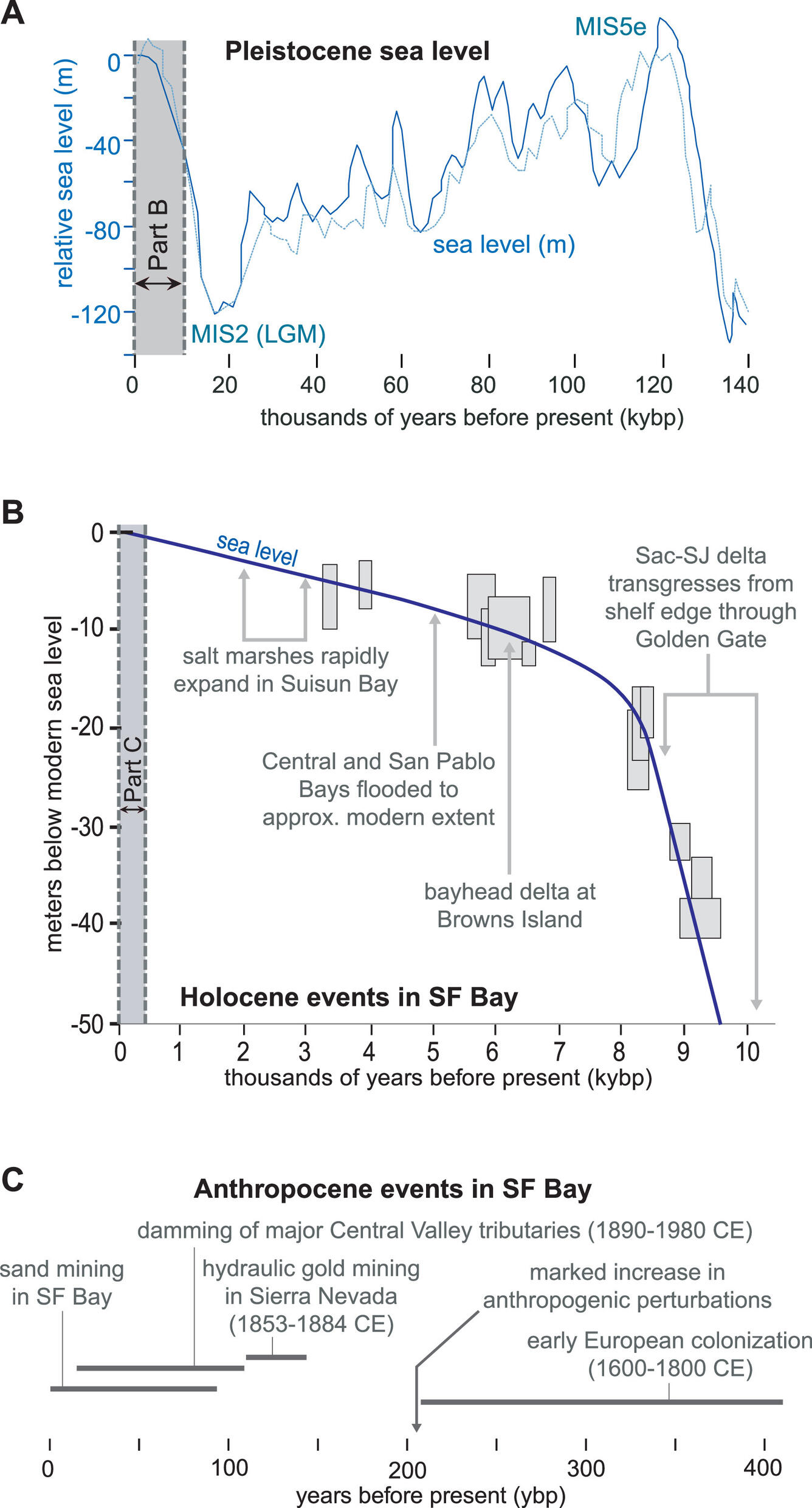
Analyzing and dating sediment samples from the Bay and its smaller embayments revealed a significant shift in sand sources over time, particularly in the Holocene epoch from 11,700 years ago to present.
During early stages of this interglacial epoch, retreating ice sheets led to rapid and significant sea-level rise. Sediment supply from fluvial sources couldn’t keep pace with sea-level rise, and the Bay consequently received sediment from both fluvial and marine sources. Anthropogenic changes to the landscape during the late Holocene also affected sediment supply: A massive influx of detritus derived from hydraulic gold mining activity in the Sierra Nevada foothills reached San Francisco Bay starting in the 1850s and into the mid twentieth century. Additionally, as much as 50 percent of the Central Valley watershed has been impounded behind reservoirs during this same period, blocking sediment transport from the upper watershed to the estuary.
The study suggests that most of the sand currently present in the Bay is a relic from periods when sea levels were lower, prior to the Holocene. More recent influxes of sand are likely imported from the Pacific coast through the Bay’s mouth.
One of the study’s key implications is the potential for abrupt reversals in sand sourcing within large structural estuaries like the Bay. The findings underscore the necessity for accurate and comprehensive models of sand inputs and transport pathways in coastal systems. Such models are essential for developing effective management strategies that balance the extraction of coastal sand resources for economic purposes with the need to sustain natural coastal environments.
RESEARCH ARTICLE: Reversal in estuarine sand supply driven by Holocene sea level rise: A model for sand transport in large structural estuaries, San Francisco Bay
By M.A. Malkowski, Z.T. Sickmann, T. Fregoso, L. McKee, D.F. Stockli, B. Jaffe
 Abstract: Coastal sand supply is a critical component of shoreline stability in the face of modern threats to coastal zones such as sea level rise or anthropogenic sediment extraction. Understanding the natural and anthropogenically perturbed dynamics of coastal systems has become a pressing challenge for coastal communities, such as the San Francisco Bay area in the United Sates, a large structurally controlled estuary system where stakeholders seek to balance the extraction of coastal sand resources for economic use and ensure sufficient sand supply for sustaining natural coastal environments.
Developing accurate and comprehensive models of sand inputs and transport pathways in different types of coastal systems is imperative to balancing these competing needs. While estuarine sediment transport has been well-studied in many systems globally, structurally controlled estuaries in tectonically active settings have received relatively less attention.
The prevailing hypothesis for sediment transport through San Francisco Bay describes active input and transport of sand from a large integrated regional catchment, through multiple subembayments, and out to Pacific coast beaches; a model contrary to prevailing understanding of highstand estuarine sediment transport in most settings.
We test this model by applying comprehensive sand provenance analysis to surface and near-surface sand deposits in and around San Francisco Bay coupled with sand residence time data from optically stimulated luminescence (OSL) dating. New provenance results include sand petrography modal abundances, bulk geochemistry, and U-Pb detrital zircon geochronology from 27 Holocene samples throughout the San Francisco Bay region. Collectively, these new results highlight marked sediment provenance and residence time differences between San Francisco Bay structural subembayments. In particular, distinct compositional differences and OSL ages exist between sand in the bayhead region of the estuary (OSL ages ca. 4 ka; Sacramento River/local provenance) and sand from the more distal bay regions and the Pacific coast (OSL ages ca. 1 ka; integrated Sierra Nevada provenance). These provenance differences better support a revised sand input and transport model with disconnected depocenters across three structurally restricted subembayments from bayhead to the Pacific coast.
New data suggest that at present the bayhead region receives limited supply from the Sacramento-San Joaquin Delta drainage with subsidiary supply from local circum-bay drainages. Sand deposited in the region from the Pacific coast through the inlet (Golden Gate) and into the estuary consists of a combination of tidal winnowing and reworking of “relic” sand from lowstand periods combined with sand eroded from Pacific coast sea cliffs, and sand supply from local Coast Range drainages. These results suggest that sand is likely not transported directly to the Pacific coast from the Sacramento-San Joaquin Delta under modern conditions.
Moreover, it is likely that structural constrictions between the main estuary and outer coast and between estuary subembayments cause abrupt cessation of sediment input from the main regional drainage during marine flooding, a feature likely common to large structurally controlled estuaries globally. This revised model for San Francisco Bay sand transport illustrates the need for research targeted at interpreting natural sand transport pathways in coastal systems where coarse sediment supply is a sustainability concern.

