

Several news sources featured in the Daily Digest may limit the number of articles you can access without a subscription. However, gift articles and open-access links are provided when available. For more open access California water news articles, explore the main page at MavensNotebook.com.
On the calendar today …
- HYBRID EVENT: Water Conservation Showcase (San Ramon) from 9am to 4:30pm. Learn more about scalable strategies and solutions to conserve one of Earth’s most precious resources: water. Since 2004, hundreds of advocates, researchers, business leaders, product manufacturers and government officials have gathered each year to address the most pressing water issues and challenges facing the state of California. Join us in person to engage with exhibitors and network with water industry professionals. If you are unable to attend in person, you may register to view individual sessions online. Click here for more information and to register.
- WEBINAR: Plastics & Climate: Exploring What We Know, Impacts on Vulnerable Communities, and How to Solve the Problem from 11:30am to 1pm. The Trash Free Waters program will be hosting a webinar to discuss the relationship between plastics and climate change. From production and transport to consumption and disposal, plastics have a profound impact on our environment, including our climate. During this webinar, three expert panelists will provide information on the effects of plastic consumption and production on climate change and answer your questions about this serious problem. Join us for this webinar to explore the nature and scale of this problem, hear about policy options to mitigate its effects, and learn about the disproportionate burden placed on vulnerable populations. Click here to register.
- WEBINAR: Eel River Forum from 1pm to 2:30pm. Public meeting to review the restoration and conservation plan draft, and open the public comment period. Click here to register.
- WEBINAR: Updates on the Yolo Bypass Wildlife Area from 7pm to 9pm. Garrett Spaan, wildlife area manager at Yolo Bypass Wildlife Area, will talk about the different management techniques that occur on the Yolo Bypass Wildlife Area to manage different habitat types. He will also discuss the planned projects on the Wildlife Area for the 2024 field season and the future projects he hopes to implement. Click here to register.
In California water news today …
Coldest storm of winter and spring to dump snow in California
 “California residents and southwestern United States motorists should be prepared for slippery travel over the passes while some thunderstorms associated with a storm system could be feisty, AccuWeather Meteorologists say. Disruptions to outdoor plans are likely, and travel may be slow in some cases due to the approaching storm. “An unusually cold storm will pivot slowly through California and the southwestern United States into the start of the weekend,” AccuWeather Expert Senior Meteorologist Ken Clark said. “The storm will push freezing levels to their lowest point of the entire cold weather season,” Clark explained. “That means it will snow over the passes in Southern California.” … ” Read more from AccuWeather.
CA snowpack in good shape after several storms. What does that mean for the water supply?
“California’s snowpack is more than abundant this year after all the recent storms, but officials say we still need to capture and store as much water as possible. With a mighty push on Tuesday, scientists measured the snow depth at Phillips Station in the Sierra Nevada – a key indicator for the water supply. The April survey is the most important since this is the peak of the snowpack. A few years ago, there was no snow at all in the area. Scientists pick six specific spots and measure how much the snow weighs. With that they can figure out the amount of water contained in the snowpack. Tuesday’s survey recorded 64 inches of snow depth – that’s 113% of average for that location. … ” Read more from Channel 7.
Radio show: California’s former Water Czar on the state’s coming “water nightmare”
“Yesterday, Gov. Gavin Newsom surveyed the Sierra snowpack and outlined a new state water plan focused on climate change. Scott and KQED climate reporter Ezra David Romero are joined by California’s former top water regulator Felicia Marcus. As the state’s top water czar, she navigated severe droughts, balancing demands for scare water by cities, farms, businesses and homeowners.” Listen at KQED.
California’s water outlook has brightened for now, but salmon and other fish are still in peril
Ian James writes, “Salmon is king. It’s a phrase I heard more than once as I interviewed people who depend on fishing and asked them what last year’s shutdown of salmon fishing has meant for them. Along the California coast from May to October, commercial fishing boats and sportfishing charter vessels are typically out on the ocean hauling in salmon. But low population numbers led to the cancellation of last year’s season, and this year fishery regulators will soon consider whether to ban fishing for another year, or allow a minimal season with restricted dates and catch limits. I spoke with people in a few fishing communities to learn how they’ve been affected by the closure, and what they think about the factors that have driven declines in salmon and other fish populations. … ” Read more from the LA Times.
Delta tunnel supporters, opponents respond to Newsom’s updated water plan

Paul Hames / DWR
“Gov. Gavin Newsom on Tuesday announced the release of the state’s updated water plan, which garnered both support and criticism. As he stood in the snow-packed Sierra Nevada for a press conference during the April snow survey at Phillips Station, Newsom said the new reality of climate extremes requires a new approach and elevated sophistication in terms of managing the water system. “The water system in California was designed for a world that no longer exists,” he said, referring to the drastic weather events that have occurred over the last decade, compared to 50 or 60 years ago. … ” Read more from SF Gate.
Press release: Governor Newsom touts importance of Delta Conveyance Project as “foundational, critical” component of state water plan to build resilience against extreme weather
“In a press release yesterday, Governor Newsom released the state’s updated Water Plan detailing the state’s plans to protect California’s water supplies from the climate crisis while boosting our state’s ability to capture and store water when dry conditions return. The Governor touted the need for the Delta Conveyance Project as a “foundational” component to the state Water Plan and “one of the most important projects this state can advance.” Here’s what Governor Newsom said: “In the past few years alone, we’ve gone from extreme drought to some of the most intense rain and snow seasons on record – showcasing the need for us to constantly adapt to how we manage our water supplies. The water plans and strategies we’re implementing are each targeted components of our overall effort to deliver clean water to Californians by capturing, storing, and conserving more water throughout the state. … ” Continue reading from Californians for Water Security.
Fairfield City Council hears update from SCWA
“The Fairfield City Council heard an update from the Solano County Water Association at Tuesday night’s meeting, and discussed the possible cutting of water allocations for Solano County communities from Lake Berryessa significantly. Spanning hundreds of miles from north of Lake Shasta to Fresno, the tributaries of the Sacramento and Sac Joaquin rivers that feed into the San Francisco Bay reach well into the Sierra Nevadas and Central Valley. The State Water Quality Control Board has noted that diminished river flows in these areas are harming fish habitats and are detrimental to the water system as a whole ecologically. The cuts, however, would leave Solano and many Northern California communities scrambling to conserve water and procure more, as the 55 percent unimpaired flow that the draft recommends would see Solano’s allocations from Beryessa cut to about 25 percent of their current levels. … ” Read more from the Reporter.
Groups say the state must stop the ongoing killing of federally protected salmon and steelhead by the Central Valley Project and State Water Project

“State and federal agencies must take immediate action to stop the unauthorized killing of thousands of Chinook Salmon and Steelhead at State and Federal water export pumps in the Sacramento-San Joaquin River Delta (Delta), according to a coalition of environmental and fishing groups. Both fish are protected under the Federal Endangered Species Act (ESA); Central Valley winter-run Chinook Salmon is also protected under the California Endangered Species Act (CESA). This is the second time in 2024 the coalition has responded to an increase in killing of legally protected fish at the pumps of the State Water Project and the Central Valley Project (Projects or Water Projects). Despite the National Marine Fisheries Service (NMFS) calling for significant reductions in the Projects’ Delta water pumping, California’s Department of Water Resources (DWR) and the federal Bureau of Reclamation (Reclamation), which own and operate the Projects, ignored these recommendations and continued to export water at rates that killed thousands of imperiled fishes. … ” Continue reading this press release.
SEE ALSO: State and federal agencies must take action to stop killing of salmon, steelhead in Delta Pumps, from Dan Bacher at the Daily Kos
Cutting the green tape with SERP
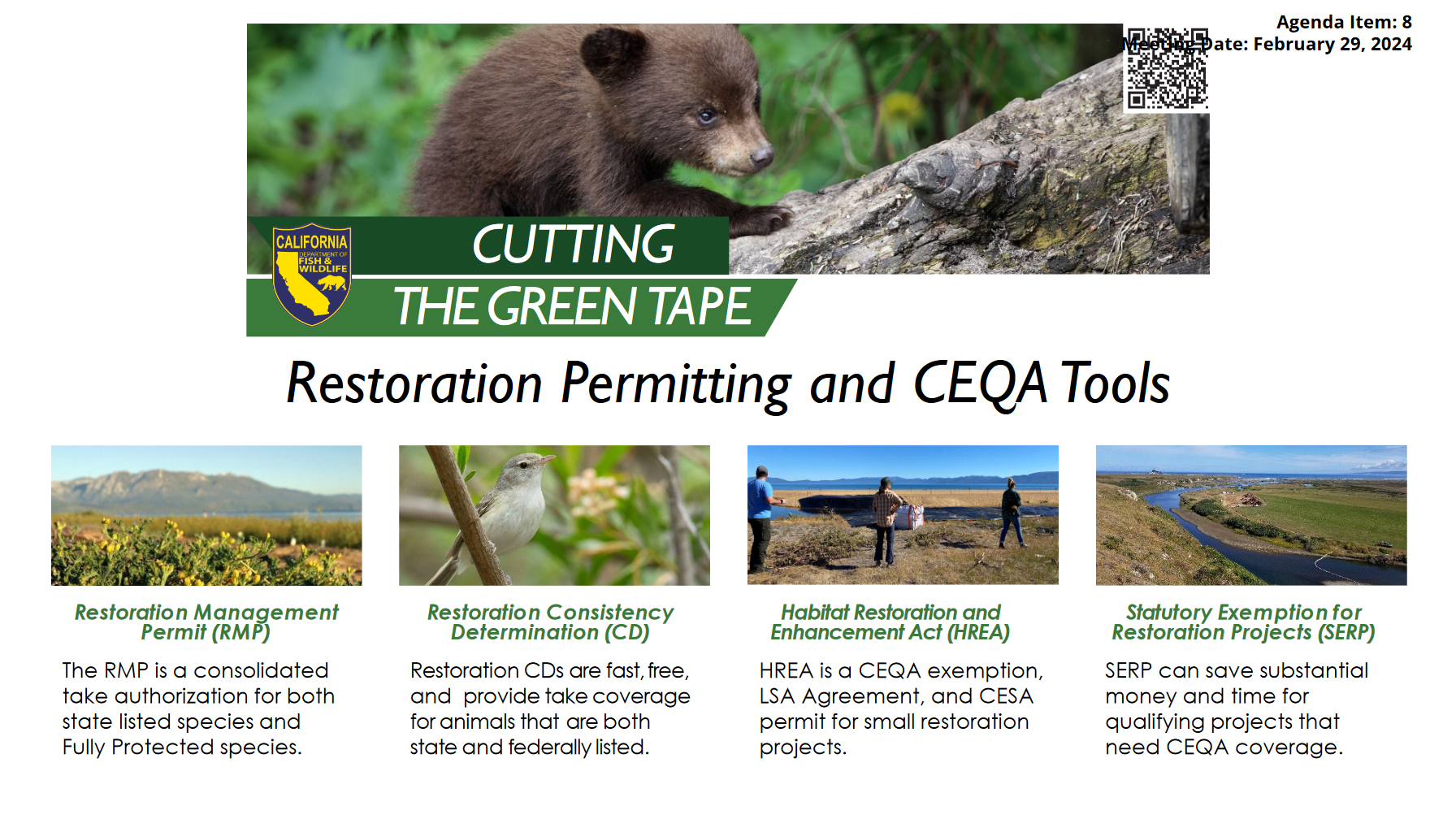 “California is known for strong laws protecting the environment; however, these policies meant to protect natural resources can unintentionally slow down projects that restore essential habitats and imperiled ecosystems. Recognizing this, the Newsom Administration signed an Executive Order in October 2020 directing state agencies to “implement actions to increase the pace and scale of environmental restoration and land management efforts by streamlining the State’s process to approve and facilitate these projects.” This has become known as the “Cutting the Green Tape Initiative.” The Cutting the Green Tape Initiative has several permitting and CEQA tools for restoration permitting, including the Restoration Management Permit, Restoration Consistentcy Determination, and the Habitat Restoration and Enchancement Act. In 2021, Governor Newsom added another tool to the toolbox when he signed SB 155, creating a CEQA statutory exemption for restoration projects that meet specific requirements. The provision is set to sunset on January 1, 2025 unless it is renewed by the legislature. … ” Continue reading from Maven’s Notebook.
Explained: The senior rights to California’s water and balancing access to safe drinking water
“Water access in California has seen growing scrutiny as the climate shifts from more extreme dry to wet swings. This results in increasing year-to-year uncertainty for both commercial and residential water availability. One area getting more attention from an ethical and practical application is the system of water rights, which first took shape in the late 1800s. Cody Phillips, with the California Coastkeeper Alliance, a non-profit focused on providing safe water for all Californians, says the right to water in the state really started with the gold rush. He says people would stake a claim to water the same way they would come out and claim land to mine. … ” Read more from Channel 10.
Water use report violation notices coming soon
“Are you a water rightsholder? Have you filed your Annual Water Diversion and Use reports for Water Year 2023? If you answered “yes” then “no,” a notice of violation could be on the way. It’s just been announced that the Division of Water Rights will be sending Notices of Violation in the next few weeks for those who have not submitted the annual reports or statements. Those were due before February 1. … ” Read more from Ag Info.
Inside California’s effort to use ocean water as a future water source
“California has more than 1,000 thousand miles of coastline and the water in the Pacific Ocean presents an opportunity for more fresh water in the state. Unlocking the opportunity takes time, money and resources, and some experts say it’s not for everyone. Desalination is being put to the test in coastal areas up and down the state. The process takes salt out of ocean water and turns it into fresh water for people. State officials, as well as private partners, focus on these areas as the best fit for this water supply. “Desalination is an important strategy for a lot of these coastal communities in California because many of them are in small watersheds and disconnected from some of the larger inter-regional and backbone infrastructure like the State Water Project and the Central Valley Project that does connect a lot of the state together,” said Kris Tjernell, the deputy director of Integrated Watershed Management for the Department of Water Resources. … ” Read more from Channel 10.
Summary of 2023 Flood Mar Forum
“At the Flood-MAR Network’s fourth biannual Flood-MAR Public Forum held in November 2023, nearly 100 Flood-MAR practitioners gathered to share success stories and lessons learned from the landmark wet winter of 2022 – 2023 and identify areas for further preparation needed to implement projects that use floodwaters for managed aquifer recharge in future wet years, for the benefit of communities, ecosystems, and agriculture.” Click here to read the summary.
How California’s fire season might shape up this year
“Luckily for us, the 2023 fire season in California was exceptionally mild. Wildland fires burned roughly 325,000 acres and damaged 70 buildings across the state last year, making the fire season one of the least destructive in the past decade and a significant departure from some terrible recent fire years. Nearly eight times as many acres — more than 2.5 million in all — burned in 2021, for example, as well as 3,500 structures. And the year before that was California’s worst on record, with 4.3 million acres burned. So what kind of fire season are we in for this year? … ” Read more from the New York Times.
In commentary today …
California enjoys healthy water supply, but battles over its uses continue to fester
Dan Walters with Cal Matters writes, “California’s major reservoirs are nearly full thanks to two wet winters, the Sierra snowpack is deeper than usual and the state is likely to receive even more rain and snow this spring. After years of drought, California’s water supply is the healthiest it’s been in the 21st century. Nevertheless, the state’s age-old jousting over water use priorities continues and may become more intense as climate change affects the amount of water available. On Tuesday, Gov. Gavin Newsom strapped on snowshoes to accompany state water officials as they measured the Sierra snowpack near Lake Tahoe and declared that it’s well over 100% of average. … ” Continue reading from Cal Matters.
Sacramento’s war on water and energy
Edward Ring, director of water and energy policy for the California Policy Center, writes, “After the deluges of 2022-23, and the rainfall season so far this year delivering an above normal snowpack and above normal rain, the drought in California is over. Even the situation on the dry Colorado is much improved, with Lake Powell and Lake Mead collectively at 42 percent of capacity, up from only 32 percent of capacity at this time last year. The reservoirs are full, and there’s snow in the mountains, but California’s farmers are still getting squeezed. The federal allocation to farmers in California’s vast Central Valley is held to 35 percent of the contracted amount, and the state water project allocation is only at 30 percent. As a result, millions of acres of farmland are going to remain fallow this year. … ” Read more from the California Globe.
Balancing Act: California’s water and food security
Jerrold H. Jensen writes, “California currently produces 69% of the nation’s fruits and vegetables and 21% of all milk. Any proposed change of the state’s water usage should consider the impact on America’s domestic food supply. Both farmers and city dwellers have dammed rivers in the foothills of the Sierra Nevada Mountains to store and dispense irrigation and drinking water. Together we have altered the historic flow into and through the San Joaquin – Sacramento Delta before emptying into San Francisco Bay. With limited supplies of surface water, pumps in the San Joaquin Valley are taking more water out of the ground than nature replaces each year. … ” Continue reading at the Foothills Sun-Gazette.
In regional water news and commentary today …
NORTH COAST
Water quality board says metals in Klamath River not a health concern
“The Siskiyou County Board of Supervisors recently proclaimed a local emergency related to concerns about heavy metals being present in the Klamath River. California’s regional water board says those worries are overblown. In late March the Siskiyou County Board of Supervisors proclaimed a local emergency related to concerns about heavy metals like arsenic and lead being present in the Klamath River. It was prompted by the ongoing removal of four hydroelectric dams on the river. JPR’s Erik Neumann spoke with Matt St. John, an environmental program manager with the North Coast Regional Water Quality Control Board about how worried people should be about heavy metals in the river. … ” Read more from Jefferson Public Radio.
Deconstruction of Copco No.1 Underway
“Following the recent successful test blast, the Klamath River Renewal Corporation (KRRC) will proceed with the removal of the Copco No.1 Dam constructed in 1918 for the sole purpose of hydroelectric power generation, has blocked fish passage for over 100 years and is expected to be fully removed by the end of August 2024. … ” Read more from the Del Norte Triplicate.
MOUNTAIN COUNTIES
Details on Spaulding powerhouse damages emerge
“Two letters filed with the Federal Energy Regulatory Commission (FERC) reveal details of the damage at PG&E’s Lake Spaulding Powerhouse No. 1, which is out of service since early March. The failure of the powerhouse, combined with a massive rockslide over the PG&E-owned starting portion of the South Yuba Canal, have effectively cut off water supplies from the higher elevations to the Bear River and Deer Creek. The State Historic Preservation Officer’s letter to FERC provides additional information on the damage discovered by PG&E. … ” Read more from YubaNet.
‘They are dinosaurs’: Tahoe sees return of giant birds
“For centuries, there was a familiar spring and summer element in the Sierra Nevada skies: hundreds of enormous white birds soaring over the lakes and mountains. On land, their courtship displays were notable from afar as they leaped, twirled and flapped their elegant black-tipped wings in complicated shows to find a lifelong mate. With a wingspan of around 7 feet and an average height of 5 feet, sandhill cranes were once easy to spot around Lake Tahoe, even from a distance. … In the past few years, they’ve occasionally been seen around Truckee and areas north of Lake Tahoe toward Sierraville and Quincy. “But in the Tahoe Basin, it’s a slightly more recent of a recolonization,” says Will Richardson, executive director of the Tahoe Institute for Natural Science (TINS). “And they’re subject to a lot more pressures from folks, hikers, recreational use, and trail use.” … ” Read more from SF Gate.
SACRAMENTO VALLEY
Video: Why Guy: Why are there barrels hanging over the American River near Auburn?
Why are there barrels hanging over the American River near Auburn? The Why Guy answers here.
NAPA/SONOMA
Groups seek to ban large-scale animal farming in Sonoma County
“Think “Sonoma County farm,” and most people will conjure an image of docile cows chewing cud or chickens scratching the dirt, idly whiling away their days among the grassy, green hills of this mostly rural, coastal Northern California county. But animal rights activists say all is not right in this region known for its wine and farm-to-fork sensibilities. They say there are two dozen large, concentrated animal farming operations — which collectively house almost 3 million animals — befouling watersheds and torturing livestock and poultry in confined lots and cages. And in an effort to stop it, they’ve collected more than 37,000 signatures from Sonoma County residents to put an end to it — forcing the county Board of Supervisors to either enact or match the ordinance themselves, or have it kicked over to the November ballot. … ” Read more from the LA Times.
BAY AREA
Bay Area storm could bring chance of thunderstorms, hail and record cold
“After 70-degree temperatures gave a summer-like feel to the Bay Area weather earlier this week, an April storm will serve as a reminder that the wet season isn’t over yet. An exceptionally cold low-pressure system is expected to move toward the Bay Area on Thursday, parking itself very close to San Francisco. This cold storm will drag the freezing level below 3,000 feet, with snowflakes as low as 1,500 feet Thursday night. This cold airmass will make the atmosphere unstable, and afternoon thunderstorms are possible in San Francisco, Oakland and San Jose as a result. It could be the coldest April day this century in some Bay Area cities. … ” Read more from the San Francisco Chronicle.
Marin public health tool gauges sea-level ‘vulnerability’
“A new online tool created by Marin County’s public health office aims to chart the risks various areas face from the rising sea level. The “vulnerability” dashboard uses social factors as well as geographic ones as the basis for its determinations. The map identifies areas in Novato, Marin City, San Rafael, Mill Valley, Kentfield and Larkspur as most socially vulnerable and with the highest flood risk. The dashboard is meant to be a community planning tool, said Dr. Matthew Willis, the county’s public health officer. He said that historically, flood risk has been measured by physical factors such as infrastructure, elevation and water flow. “I think our tool, our goal, was to contribute to that conversation and to add important context to more dimensions around vulnerability,” Willis said. “But from a human health standpoint, any disaster, whether it’s a heat wave or a flood, the people who tend to suffer the worst consequences are people who have social vulnerability.” … ” Read more from the Marin Independent Journal.
SAN JOAQUIN VALLEY
Groups and Tribe urge regulators to control toxic pollution from selenium in Mud Slough
“In an April 1, 2024 letter to three water boards, fishing and conservation groups and a Tribe have urged regulators to control recently measured excess levels of selenium in Mud Slough. Mud Slough drains selenium-impaired land on the west side of the San Joaquin Valley into the San Joaquin River and ultimately San Francisco Bay. Selenium is known to cause reproductive failure, deformities, and death in fish and waterfowl. “Our groups have spent over a decade at the water boards and in court trying to bring runoff from Mud Slough into compliance with water quality standards,” said Chris Shutes, Executive Director of the California Sportfishing Protection Alliance. “Past selenium discharges accumulated in downstream waters, impacting fish and causing deformities. The water boards need to act to protect fish and wildlife from this toxic pollutant.” … ” Continue reading this press release from the CSPA.
How much water can Stanislaus farms and cities expect as growing season gets underway?
“Winter brought just average rain and snow to Stanislaus County’s main watershed, but most farmers will get abundant supplies. That’s because reservoirs continue to hold much of the runoff from last year’s truly wet conditions. Only in parts of the West Side will water be limited. The storms also boosted groundwater, which is part of the supply in many places. City residents, too, can expect no cutbacks, but they still have to follow rules against outdoor watering in the afternoon. Too much demand on a hot summer day can tax the distribution system. … ” Read more from the Modesto Bee. | Read via AOL News.
New Melones tops 2 million acre feet of water storage
“New Melones Reservoir on the Stanislaus River is now at 2,010,765 acre feet of storage. And the expectation is between the above average snowpack on April 1 plus continuing storms it could near its 2.4 million acre-foot capacity by month’s end. “New Melones has been releasing above minimum baseflow for much of the winter and into spring because new Melones was relatively full in the fall and needed to maintain at or below 1.970 million acre feet for flood control purposes in the winter,” noted South San Joaquin Irrigation District General Manager Peter Reitkerk. It means water releases will continue to be robust but not as heavy as a year ago. … ” Read more from the Manteca Bulletin.
Snowpack above average, Friant water allocation up to 95 percent
“Tuesday’s snow survey was expected to bode well when it came to an increase in the water allocation for local contractors. The federal Bureau of Reclamation didn’t even wait for the survey. In the wake of an expected excellent report coming from Tuesday’s snow survey, Reclamation significantly increased its water allocation through the Central Valley Project for Friant contractors on Monday. Reclamation increased its water allocation for Friant Class 1 contractors from 65 percent to 95 percent, meaning they will be allocated 760,000 of 800,000 acre feet. In its initial allocated Reclamation issued a 60 percent allocation. … ” Read more from the Porterville Recorder.
New Kern County groundwater bank gets underway with another shot of public funding
“The $171 million Kern Fan Groundwater Storage project – with a unique “eco-twist” – received another chunk of public funding just as the first section of the 1,300-acre project had a formal christening on Wednesday. Officials with Rosedale-Rio Bravo Water Storage District, Irvine Ranch Water District and the Bureau of Reclamation gathered at the project site near Enos Lane west of Bakersfield to look over construction of the first part of Phase 1, which began in February. The Bureau announced earlier in the week that it had approved a $3.9 million grant for the project, which is in addition to $4.7 million awarded by the Bureau in 2023. That funding requires a 75% match from Rosedale-Rio Bravo and Irvine Ranch. … ” Read more from SJV Water.
SOUTHERN CALIFORNIA
‘Unseasonably cold’: April storm bringing winter temperatures, low snow levels to California
“It might feel like spring Wednesday, with highs across Los Angeles reaching into the high 70s, but Thursday is going to be a “shock to the system,” weather experts say. Temperatures on Thursday and Friday are expected to drop 15 to 20 degrees from Wednesday’s highs as a cold storm blows across California, bringing low-elevation snow, showers and the potential for severe thunderstorms. Some Southern California areas could feel historic low temperatures Friday, National Weather Service meteorologist Mike Wofford said. “With the system coming in, we’re going to see a dramatic drop [in temperatures] tomorrow,” Wofford said Wednesday from the weather service’s Oxnard office. “[There will be] an almost 20-degree drop in temperatures, and even cooler on Friday.” … ” Read more from the LA Times. | Read similar story from the LA Daily News.
L.A. County faces $12.5 billion in climate costs through 2040, study says
“A first-of-its-kind report has estimated that Los Angeles County must invest billions of dollars through 2040 to protect residents from worsening climate hazards, including extreme heat, increasing precipitation, worsening wildfires, rising sea levels and climate-induced public health threats. The report, published this week by the nonprofit Center for Climate Integrity, identified 14 different climate adaptation measures that authors calculated would cost L.A. taxpayers at least $12.5 billion over the next 15 years, or approximately $780 million per year. The vast majority of those costs — more than $9 billion — will be incurred by local municipal governments, including the cities of Los Angeles, Long Beach and Santa Clarita, the report said. “These numbers don’t include the costs of recovering from disasters — from extreme weather events that knock out power or damage infrastructure or do all the kinds of things they do,” said Richard Wiles, president of the Center for Climate Integrity. “So it’s a very conservative estimate, and yet it’s a really big number.” … ” Read more from the LA Times.
Costa Mesa’s abundant water supply bolstered with Mesa Water’s two new wells
“Mesa Water District (Mesa Water®) bolstered its abundant water supply with the completion of two new potable (drinking) water wells that increase local groundwater production capacity and keep Mesa Water drought-resilient. Croddy Well No. 14 and Chandler Well No. 12 are now Mesa Water’s largest producing wells – each pumping approximately 4,000 gallons per minute of local, clean, safe water, and adding more than 50% to the community’s water supply. The district now has nine wells to pump water to serve the community. “Mesa Water has a perpetual agency philosophy – we’re committed to investing in our infrastructure to ensure water reliability,” says Mesa Water Board President, Shawn Dewane. “Increased production from the wells allows Mesa Water to meet peak water demand now and for future generations.” … ” Read more from Mesa Water.
SAN DIEGO
‘Retreat Now’: City board votes to move part of Carlsbad Blvd due to rising sea levels
“A plan to move Carlsbad Boulevard due to rising sea levels is moving forward after a unanimous vote in the North County city this week. The portion of roadway, formerly known as old Highway 101, that could be affected abuts the beach and runs from Palomar Airport Road to just before La Costa Avenue. Carlsbad’s Beach Preservation Commission voted on Tuesday to recommend the option being called “retreat now.” The proposal now moves to the Carlsbad City Council, which is expected to review the commission’s on April 23. The approximately one-mile stretch of southern Carlsbad Boulevard has been hit by waves and rocks during winter storms and high tides. The project would move southbound lanes to the east, next to the northbound lanes, which are farther above sea level. … ” Read more from NBC 7.
Along the Colorado River …
Five major proposals for post-2026 management of the Colorado River
 “With the submission of two additional proposals last week, we now have five major proposals for post-2026 Colorado River management. … ” Get the list and the links to all 5 at the Inkstain Blog.
Cherish that hamburger. It cost a quarter of the Colorado River, according to researchers.
“Next time you take a bite out of a juicy hamburger or chunk of cheese made in the western U.S., say thank you to the Colorado River. Researchers released the most complete accounting so far of how the river’s water is used. They found that alfalfa — used as feed for beef and dairy cows — sucks up more water than all the cities and industries in the enormous Colorado River Basin. The researchers incorporated new factors, like water used by nature, Mexico and out-of-basin water transfers, that haven’t been counted before. And with those numbers, the researchers made it clear that water use in the basin needs to drop by 22% to 29% to stabilize historically low reservoirs. … ” Read more from the Colorado Sun.
ArcGIS online helps detect and analyze land subsidence in Arizona
“The earth’s surface is in a constant state of change, and one reason for this is land subsidence. More than just a reason for localized sinkholes, land subsidence can cause entire agricultural areas, river deltas, and even urban areas to sink. A global problem with far-reaching effects, land subsidence is caused by a range of factors, including mining activities, water saturation of sandy soil, soil compaction, and thawing permafrost. Exacerbated by factors ranging from drought to sea level rise, land subsidence can damage roads, building foundations, and subsurface infrastructure such as water and wastewater pipes and utility conduits. … ” Read more from ESRI.
Biden-Harris Administration announces $25 million from Investing in America Agenda to protect wetlands in Arizona
“The Department of the Interior today announced a $25 million investment from President Biden’s Investing in America agenda to protect and maintain two areas important for resilience and drought mitigation in the Southwest — the Yuma East Wetlands and Topock Marsh in Arizona. “Through President Biden’s Investing in America agenda, we have historic new resources to safeguard western communities in the face of severe drought conditions, restore ecosystems and build a sustainable future,” said Principal Deputy Assistant Secretary for Water and Science Michael Brain. “Building on our significant milestones this year to protect the Colorado River System, we are continuing to bring every tool and resource to bear to protect the stability and sustainability of the Colorado River System and increase water efficiency across the West.” … ” Read more from the Bureau of Reclamation.
Snow drought plaguing Pacific Northwest, Rockies
“With the snow season drawing to a close across the West, the Pacific Northwest and northern Rockies face a snow drought that could spell disaster later in the year. Many climate stations in Washington state, northern Idaho, Montana and much of northern Wyoming report a snow water equivalent measurement at 30% of average or less. Some stations in western Montana and in the Bighorn Mountains of northern Wyoming report record lows for snow water equivalent, according to the National Oceanic and Atmospheric Administration’s National Integrated Drought Information System. “A dry March worsened conditions, with some locations receiving less than 50% of average precipitation for the month,” NOAA scientists said in a statement Wednesday. Some areas have already reached the peak snowfall expected during the water year. … ” Read more from the Courthouse News Service.
SEE ALSO: Snow Drought Current Conditions and Impacts in the West, from NIDIS
Also on Maven’s Notebook today …
FUNDING OPPORTUNITY: Call for Proposals: 2025 Delta Research Awards
OPPORTUNITY TO COMMENT: Draft Policy for Standardized Cost Reporting in Municipal Stormwater Permits
AVAILABLE FOR COMMENT: Workplan Addressing Uncertainty and Validating the Groundwater Protection Formula, Values, and Targets

