

The session began with Karen Kayfetz, program manager at the Delta Science Program, discussing what it means to practice adaptive management and the work that her staff at the Delta Science Program do to provide support and leadership for the use of science-based adaptive management in the Delta to achieve the coequal goals. Then a series of lightning talks highlighted recent efforts to develop adaptive management and monitoring plans with speakers sharing their key challenges, highlights, and/or lessons learned from writing their plans.
What does it mean to practice adaptive management?
 Adaptive management is a science-based structured approach to improving understanding of environmental and water management problems and uncertainties, said Ms. Kayfetz. It’s a systematic approach for improving natural resource management by learning from the outcomes of our actions to modify the environment. The concept of adaptive management explicitly links learning with policy and implementation.
Many resource planning documents call for the use of adaptive management—for example, the Delta plan, which uses a three-phase nine-step adaptive management framework pictured here.
“Many managers refer to adaptive management as part of their processes,” said Ms. Kayfetz. “However, contrary to common belief, adaptive management is much more than simply tracking and changing management directions in the face of failed actions.”
“Adaptive management requires that projects clearly identify and articulate their goals and the measurable objectives that they’ll use to evaluate progress towards those goals. Adaptive management includes exploring pathways to meet management objectives and predicting the outcomes of alternatives based on conceptual and numerical models. It requires implementing one of those alternatives or more than one, monitoring to learn about the impacts of management actions, and then using the results to update knowledge and adjust management actions on that project or elsewhere on the landscape. Adaptive management is explicitly focused on this process of learning and adapting, and requires partnerships of managers, scientists and other stakeholders who learn together how to create and maintain sustainable environmental systems.”
 Over the next three days, participants will hear about many of the practices and mechanisms people have put into place to facilitate adaptive management, the partnerships and support structures that make adaptive management possible, and stories of learning and adapting.
This session starts with the practice of adaptive management planning. Then, four lightning talks will present stories of the first crucial phase of adaptive management, which is coming up with a plan and writing it all down.
“An adaptive management plan is where we write down what we think will happen, how we think we’ll know if it’s happening, and what we’ll do if it doesn’t happen as we thought,” said Ms. Kayfetz. “This is where we start the forum, because, without a plan, we’re not doing adaptive management. Not so much because the document is important, though it is, but because the process of building it is important. It’s the process of building a shared understanding of our goals, of agreeing on how we think actions will translate into beneficial environmental outcomes, of agreeing on what we think it will take to know that we’re achieving our goals, and then writing it all down, sharing it with others, revising it, sharing it again, revising it again. It’s this process that catalyzes our best problem-solving. It’s this process that ensures that we’re using the best available science as a foundation for our planning and that we’re producing the best possible science to inform adaptation and design future projects.”
Venues for Adaptive Management Review
Three primary venues are explicitly focused on workshopping adaptive management plans in the Delta as they are being created:
Interagency Adaptive Management Integration Team (or IAMIT)
 The Interagency Adaptive Management Integration Team (or IAMIT) is a group convened by the Delta Science Program. It is comprised of scientific and technical staff from local, state, and federal agencies and certain key stakeholder groups that have roles in implementing, funding, regulating, or otherwise supporting and overseeing adaptive management of projects in the Delta. It serves as a technical team that provides input and guidance on adaptive management for current and future efforts at a high level that cross-cuts individual agency missions.
“Project managers are encouraged to use this venue to discuss their project, resolve issues that they’re experiencing, and receive technical and regulatory feedback on project development,” said Ms. Kayfetz. “In this way, the IAMIT can act as a forum for informal joint consultation and a single venue for project review and advice to facilitate meeting regulatory and adaptive management needs. The hope is to create efficiencies for project proponents to enhance coordination between agencies and to increase pathways for integrating adaptive management into projects.”
The role of the IAMIT:
-
- To offer support and technical guidance to project proponents with inquiries related to adaptive management planning or implementation
- To review project designs and advise project proponents on how to increase chances of achieving project objectives and minimize adverse effects
- To advise on the use of standardized monitoring protocols
- To discuss how project designs and monitoring plans may be able to address scientific uncertainties to help inform future restoration projects
- To identify potential connections to researchers that may help projects address uncertainties outside the scope of that individual project’s monitoring plan or which could facilitate the development of active adaptive management studies at the project site.
The IAMIT welcomes presentations from projects post-construction and during the monitoring phases on lessons learned so that those lessons can be considered and applied in future consultations and for updating conceptual models.
The IAMIT has a webpage with numerous resources to support adaptive management planning in the system. These include example plans, information on regulatory requirements for adaptive management, a compilation of existing landscape-level conceptual models, a compendium of monitoring frameworks, and links to various environmental data resources that can be used for project planning. https://deltacouncil.ca.gov/delta-science-program/interagency-adaptive-management-coordination
Suisun Adaptive Management Advisory Team
 The Suisun Adaptive Management Advisory Team is one of several groups supporting the implementation of the Suisun Marsh Habitat Management, Preservation, and Restoration plan, commonly known as the Suisun Marsh Plan. The Plan is a 30-year comprehensive plan that addresses habitats and ecological processes, public and private land use, levee system integrity, and water quality through tidal restoration and managed wetland activities in the marsh. The Suisun Marsh Plan’s purpose is to create a balance between the protection and enhancement of managed wetlands and the restoration and protection of tidal wetlands. The Suisun Adaptive Management Advisory Team’s purpose is to support the application of adaptive management in the implementation of the Suisun Marsh plan.
The AMAT meets quarterly and invites projects to give presentations to the group at four phases in their planning process:
In the initial stages of the project, experts in the group provide peer reviews of project design and work to inform early adaptive management decisions using the best available science as understood by the experts in the group. At this phase, projects also receive support in thinking about science and research that could be done at the site.
Subsequent check-ins occur at 40% design and 95% design to address potential adaptive management opportunities and discuss and coordinate monitoring requirements for various permits.
In the final phase after project completion, projects present about the lessons learned one year and three to five years post-construction. These presentations help the AMAT group to take lessons learned and apply them as appropriate to other Suisun Marsh projects and continue to coordinate an interagency context on facilitating adaptive management across the restoration projects.
In addition to meeting with projects, the Suisun AMAT also supports the Suisun Marsh Plan’s adaptive management by tracking the evolving state of knowledge on key management uncertainties identified in the plan and updating underlying conceptual models based on new scientific information coming from research or restoration project monitoring. The group also assists the agencies with tracking the achievement of the restoration target goals of the Suisun Marsh plan overall.
Delta Plan Consistency Early Consultation and Adaptive Management Liaisons
 Ms. Kayfetz then turned to Delta Plan consistency early consultation and the services provided by her staff, known as the Delta Science Program Adaptive Management Liaisons.
Ecosystem and water management projects in the Delta and Suisun Marsh will typically be required to demonstrate consistency with the Delta Plan, including meeting the requirements of having an adaptive management plan. The Delta Stewardship Council has staff who specialize in meeting with project proponents to align their projects with the Delta Plan’s regulatory policies. Several of these staff, referred to as the adaptive management liaisons, work specifically to support projects as they prepare their adaptive management plans.
Some of the roles of the adaptive management liaisons include:
- Providing advice on the availability of conceptual models and numerical models
- Providing information on the regional monitoring activities that may be relevant to a project,
- Providing information on relevant research projects, and recent findings from research that can be useful to aid the project in their planning or their adaptive management
- Providing advice on potential active adaptive management experiments that could resolve key uncertainties for that project or related projects.
- Providing advice on potential funding avenues for research and help make connections with other relevant research efforts
“We work with both groups that I just mentioned to help connect projects to those groups as appropriate,” said Ms. Kayfetz. “To connect with any of these groups, you can reach me and the Delta Science Program adaptive management liaisons at AdaptiveManagement@Delta council.ca.gov.”
Other adaptive management venues
There are many other collaborative spaces to support components of adaptive management, such as the development of conceptual models and monitoring frameworks, or organizing thinking around a specific set of projects.
The Collaborative Science and Adaptive Management Program (or CSAMP) and its Collaborative Adaptive Management Team (or CAMT) focus on science and adaptive management issues related to the current and future biological opinions for the operations of the State Water Project and the Central Valley Project. This includes science underlying the specific water management and habitat restoration enhancement actions listed in those biological opinions, which are focused primarily on improving the resilience of Delta smelt and salmonids, two of the special status species in the Delta. Click here to learn more about CSAMP.
The Fish Agency Strategy Team (or FAST) works directly with habitat restoration projects seeking credits towards the restoration requirements of the biological opinions for Delta smelt and salmonids for the operations of the state and federal water projects. One of the requirements for receiving credits is a long-term monitoring and management plan where projects lay out their approaches to evaluating the achievement of project objectives and adaptive management actions that may occur to ensure continued habitat benefits to protected species. The FAST meets for interagency review of those plans, among other components.
The Bay Restoration Regulatory Integration Team or BRRIT is not explicitly focused on adaptive management, but operates similarly to the IAMIT, the Suisun AMAT, and FAST in that it brings multiple regulators together to coordinate on permitting for multi-benefit habitat restoration projects in the bay and associated flood management and public access infrastructure. Click here to learn more about BRRIT.
LIGHTNING TALKS
NORTH DELTA FOOD SUBSIDY ACTION: Managing a flow pulse for food support
Dr. Brittany Davis, a Senior Environmental Scientist Specialist with the California Department of Water Resources, kicked off the lightning talks with the highlights of adaptive planning for the North Delta Food Subsidy Action.
The San Francisco Estuary has low pelagic biomass, and productivity has been declining since the mid-1970s. This decrease in productivity has affected other levels of the food web and is hypothesized to be a main factor contributing to the decline in fish food and native fishes such as Delta smelt.
 Regionally, however, some areas can provide a good source of food to the Delta, but often, summer-fall habitat conditions can limit their benefits. One of those regions is the Yolo Bypass. During winter and spring, when the floodplain is inundated, food is transported downstream to the Delta. When diversion rates in the Yolo Bypass are high during summer and fall, flows are actually reversed, transporting food away from the downstream areas of the estuary where we want it.
DWR came up with the idea for the flow action after observing some unusual flows in 2011 and 2012, where large agricultural flow pulses in the bypass were followed by a downstream Delta plankton bloom. The study objectives were to use existing infrastructure to redirect water through the Yolo Bypass and create positive outflow to increase food and productivity, redistribute waters, and transport food to downstream regions to benefit Delta smelt.
DWR takes an adaptive management approach to annually plan, implement and evaluate this action, which requires considerable coordination between several agencies, reclamation districts, and local landowners.
 During planning, DWR identifies all stakeholders and engages them in the project to understand all interests. Planning meetings are held for deciding the managed flow action, which is based on many factors, such as water year type, water availability, coordination abilities, and consideration of high priority projects in the area that might impact this action, such as construction or restoration.
Concurrent with planning operations, DWR develops a work plan that describes the science and monitoring activities that will be conducted to evaluate the managed flow pulse effects on water quality and biota. The work plan also describes project objectives, predictions, sampling design, approaches to analysis, and how the project is adaptively managed. DWR then holds stakeholder meetings where work plans are shared for feedback and concerns are addressed.
 During the study period, DWR implements the coordinated operations to generate the flow pulse and monitors the water quality and biota across regions. Following each action, they take a comparative approach to evaluate the effects of the pulse on water quality and the food web by comparing parameters before, during and after the pulse, comparing regional habitats and historical trends; and modeling with and without the pulse.
“There are many challenges with managing this action,” said Dr. Davis. “The annual cycle is really tight for planning, and we’re often adapting on the fly. There’s uncertainty in the water year type, precipitation, water available for the action, agency coordination, land use, external Delta requirements, and other species management considerations. Also, because the spatial scope is so large, there are a lot of operation structures within the area that may need repairs or construction that can delay the action timing or lead to no action at all.”
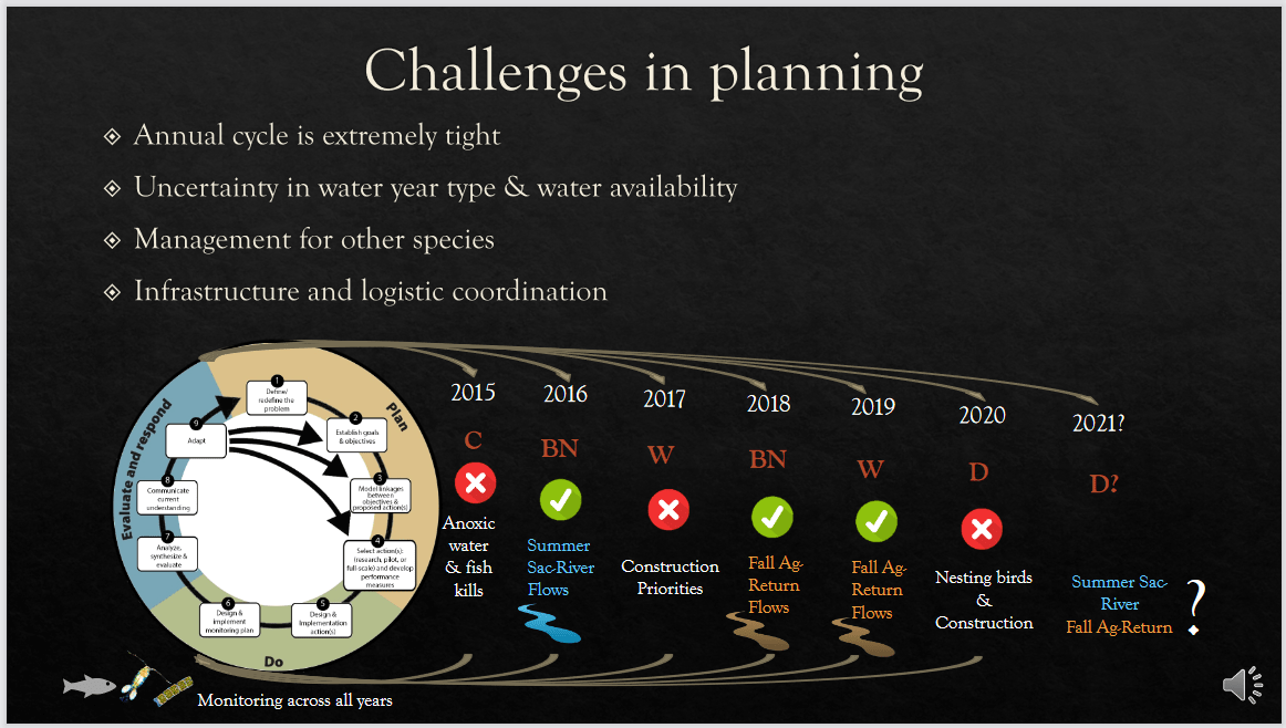 Below is a summary of six years of planning this action, and due to some of these described influences, only three actions have been conducted to date.
“Some of the key lessons learned on this project and adaptive planning are focused on what went well,” said Dr. Davis. “Our study demonstrated that existing water infrastructure can be adequately managed to manipulate summer flows in the north Delta. This is consistent with our predictions, and the managed flow pulse had quantifiable and meaningful effects on the overall system and food web. We’ve had good stakeholder engagement and agency coordination on the project.”
“What could be improved? We still need to identify and explore some of the knowledge gaps, intentionally develop some pilot efforts, and we need to find additional resources to support synthesis efforts.”
 “Lastly, go with the flow,” advised Dr.. Davis. “Yes, that pun is intended. Plan for the unexpected, plan early, have contingency plans, and be willing to shift priorities if the costs outweigh the benefits.”
She closed by acknowledged the management, funding, and operational support for the project from the Interagency Ecological Program, state and federal agencies, local landowners, reclamation district managers, and water operators.
SOUTH BAY SALT PONDS: Formation of the South Bay Salt Pond Restoration Project’s adaptive management plan
John Bourgeois is currently the Deputy Operating Officer for Watershed Stewardship and Planning at Valley Water, formerly known as the Santa Clara Valley Water District. Before that, he served for nine years as the executive project manager for the South Bay Salt Pond Restoration Project.
The South Bay Salt Pond Restoration Project, located at the southern end of San Francisco Bay, is the largest tidal wetland restoration project on the West Coast. The Project will restore 15,100 acres of industrial salt ponds to a rich mosaic of tidal wetlands and other habitats when complete. It began in 2003 as a public-private partnership when the lands were transferred into public ownership. The Project is located in a highly urbanized part of the estuary, which presents opportunities as well as constraints. Also, working at this scale, there were many concerns about how to move forward effectively.


“Early in the project, we determined what we thought were the key uncertainties – what don’t we know about the project to work at the scale and in this particular setting,” said Mr. Bourgeois. “Despite all of these key uncertainties, there was one that drove the structure of the project, and that was the concept of ecological tradeoffs. We’re trying to restore some of the lost tidal marshes in San Francisco Bay for some of the protected species, such as the Ridgeway’s rail and salt marsh harvest mouse. But some species actually like the salt pond habitat; for example, the western snowy plover here, which is federally threatened and nests on the salt flats. So we have this tension set up between species that need the salt marsh and species that like the existing conditions that are utilizing those existing habitats. How do we move forward?”
 The South Bay Salt Pond Restoration Project is not just a project but rather a program that will be implemented in multiple phases over a 50-year timeframe.
“So we bookended what we thought the low end of restoration and the high end of restoration could look like at 50% to 90%, but where we actually end up is subject to adaptive management,” said Mr. Bourgeois. “That’s where we kind of fit into this classic adaptive management wheel that we’re so familiar with.”
 Mr. Bourgeois then briefly ran through how it works in operation from day to day and making decisions. He presented a graph, noting that on the X-axis is time and on the Y-axis is a monitoring parameter, such as bird numbers, fish, or acres of tidal marsh. The solid line is the environmental baseline.
Now being a restoration project, we want to do good things, so we have a target, such as increase bird numbers or increased acres of marsh, represented by the dashed line at the top. We’re shooting for a target, but there’s always a chance something may not work. So we have a negative threshold of significance established shown on the graph in the dashed and dotted line down towards the bottom of the graph. The threshold of significance is the line below which we do not want to cross, and it is documented in the project’s NEPA and CEQA documents. However, before we get to those thresholds of significance, we have a trigger to take action, shown in the dotted line. And that’s where the adaptive management process comes in.
“In reality, once the project starts moving through an actual trajectory, it could look like any one of these things: it could be on target, or it could be headed for something negative, so we have to come up with a framework by which to address all these possibilities,” Mr. Bourgeois said. “We did that through what we call the Big Table. And it’s called that because it’s 11×17, it runs for about 13 pages, and it covers the gamut of all possibilities.”


Mr. Bourgeois then gave an example using sediment dynamics. “We have the category of monitoring that we’re talking about. It’s linked specifically to a project objective. From there, we establish what the restoration target is, what the monitoring parameter and methods are to monitor it, what is the spatial scale we’re talking about (pond specific or regional)? At what spatial scale are we expecting results? And what is the timeframe for decision-making? Is this something we can determine on an annual basis? Or do we need to look a decade or two out to actually make this decision? What is our trigger for action? What will occur to cause us to take some corrective measures? What are the questions we need to be asking so that we can make more informed decisions? And then finally, what is the range of those potential management actions that we could undertake?”


With adaptive management, communication is very important. The Salt Pond Project has a centralized project management team which are the decision-makers. The project management team is closely linked to the science team; there is a lead scientist as a liaison. It’s also important to communicate with the broader group of stakeholders and the interested public.
“This communication network is really important for decision-making,” Mr. Bourgeois said.


FISH RESTORATION PROGRAM: Project-level Adaptive Management and Monitoring Plans to address program-level objectives
Dr. Stacy Sherman is a Senior Environmental Scientist at the California Department of Fish and Wildlife, where she manages the Fish Restoration Program Monitoring Team. In her presentation, she discussed some of the principles they use to develop project-level adaptive management and monitoring plans or AAMPs to adjust program-level objectives.
The Fish Restoration Program is a collaboration between the Department of Water Resources and two units within the California Department of Fish and Wildlife. Collectively, they plan, implement and monitor over 8000 acres of tidal wetland restoration in the Delta and Suisun Marsh. This restoration is required by federal and state permits for the operation of the State Water Project. It is meant to primarily benefit listed fish species, particularly Delta smelt, longfin smelt, and chinook salmon.
 Fish Restoration Program sites are scattered throughout the North Delta Arc. There are 11 restoration sites, of which six have been restored in the past couple of years, shown in blue. The parcels in white are still in the planning stages, and those in green are the reference sites.
Each project is a major construction project, and so there are many permits required. “For us, monitoring goes with those permits,” Dr. Sherman said. “So we need to know what monitoring to include long before construction ever starts as a good chunk of the monitoring is construction compliance, such as did you follow your plans, and were your avoidance minimization and mitigation measures properly carried out?”
Dr. Sherman’s team is focused on monitoring for adaptive management of the system, so they are looking at the effectiveness of tidal wetland restoration and if the project is providing fish food and habitat for listed species. The monitoring that’s included in an adaptive management monitoring plan for a particular project needs to be able to roll up to cumulatively assess the effects of the program. She gave four principles that they follow to make that possible:
Principle 1: Get input early on
 Dr. Sherman said the first principle is to get a lot of input and do it early and often, including pre-consultation with the permitting agencies. They also have a body of scientists interested in tidal wetland monitoring who participate in the IEP project work team that exists for that purpose. The work team has put together a series of conceptual models and even monitoring plan guidance to help projects with similar objectives to Fish Restoration Program objectives develop compatible adaptive management and monitoring plans. You can join the project work team and/or get a copy of this monitoring plan guidance by emailing Stacy.Sherman@wildlife.ca gov.
Principle #2: Use comparable methods
 Their second consideration was to use all available data and not reinvent the wheel. “We made sure to look at all of the great long term surveys that are already operating in our area and complement them when we can,” said Dr. Sherman. “We also use methods that are as comparable as they can be while still addressing our objectives. And we freely share our standard operating procedures with anyone who would like to do the same.”
Principle #3: Don’t forget reference sites
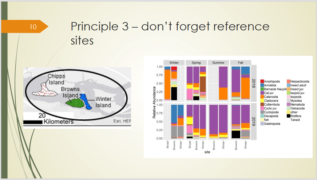 It’s really important to keep in mind the context of this dynamic system. And to make sure that reference sites are monitored both before and after restoration as well.
Principle #4: Retain flexibility
 The Adaptive Management and Monitoring Plans are written to cover ten years post-construction; the permits are the same. Dr. Sherman noted that they were also written before we understood the variability with the wetlands, and the level of effort needed to detect an effect was known.
“Our strategy was to maximize the numbers of samples that we could take with the recognition that we can’t sample everything at the highest intensity at all 11 sites every year,” she said. “So including “up to” language helps us to have a little bit of flexibility.”
In conclusion …
 “While I didn’t label this a principle, the level of monitoring needed to adaptively manage a system doesn’t happen without a good chunk of money and a really good team, so I thank my funders and team.”
SUISUN MARSH: Individual management plan updates
Dr. John Takekawa is the Operations Manager with the Suisun Resource Conservation District. In his presentation, he discussed efforts to update the adaptive habitat management plans in Suisun Marsh. He also noted his coauthor for this presentation is Jesirae Collins.
 Wetland management has been underway in Suisun Marsh since the 1880s. In the past 50 years, there have been substantial efforts to increase the conservation in the marsh, including trying to develop individual plans for each of the parcels. It was legislated in the late 70s and accomplished first in the early 1980s. However, it’s been almost forty years since those plans have been developed, so they need to be updated.
The original management plans provided information on the acreage, the type of infrastructure, and the different types of biota for each property which the landowners used to direct management of their wetlands.
“In the update, we’ve chosen to increase the spatial data available to landowners,” said Dr. Takekawa. “First, we’ve worked with BCDC to use ArcGIS Online and provide data sets that BCDC and SRCD can use to look at infrastructure and update it as it changes, which occurs regularly. It also provides basic information on imagery of habitats and LIDAR imagery for information on elevations that we have put into ArcGIS.”
The work included numerous meetings with 123 different landowners through Zoom, in person, and by conference calls.
Each plan includes basic information, a soil map, elevation modeling map, and infrastructure – about 20 pages of information. The plans also include an overview of the habitat regulations that have to be followed, the Best Management Practices for the wetlands, the regulatory requirements that apply to their property, and the management options they could do to alter the vegetation components or habitats.
 “We provided a very large set of resources that we ended up including as appendices within the website that we have and putting in information including forms, letters, and other kinds of information that landowners could use every year to update the information on their clubs,” said Dr. Takekawa.
Now that the background work has been accomplished, they are working on completing final drafts of the management plans for the first time in 40 years. Once completed, they will have landowners sign off on them and then forward them to BCDC for final certification.
“Something I think everyone should consider as they’re doing the adaptive management plans is that it’s difficult to keep them up to date, and some thought and effort should be put into having that be an easy process,” he said. “If people want to hear about our experiences, feel free to contact me at any time.”
CENTRAL VALLEY IMPROVEMENT ACT: Data management strategy
Megan Cook is the Science Coordinator for the Central Valley Project Improvement Act program or CVPIA. Her presentation focused on the CVPIA’s overarching data management strategy. She acknowledged coauthor Sadie Gill with Flow West who provides the modeling and data management expertise to the CVPIA program.
 The Central Valley Project Improvement Act is co-implemented by the US Fish and Wildlife Service and the Bureau of Reclamation. The CVPIA establishes abundance goals for the four runs of chinook salmon, steelhead, and green and white sturgeon. To meet these goals, they have established a science-based prioritization and adaptive management process that uses structured decision-making.
“My primary role is to coordinate the CVPIA Science Integration Team or SIT,” said Ms. Cook. “This group is a voluntary collaborative team that provides scientific and technical expertise to inform and interpret a set of decision support models, and it’s through this group that structured decision-making and adaptive management processes occur.”
The result of the Science Integration Team’s process is the five-year Near-Term Restoration Strategy which was just completed last year. The strategy includes priority restoration actions for Chinook salmon and priority information needs for chinook, steelhead, and sturgeon. Although it is intended to cover five years, the SIT process enables annual updates if new information improves the models and then the subsequent prioritization process.
 The slide is a diagram of the Science Integration Team Process. Through structured decision-making, the SIT develops specific objectives and determines the best decision alternatives to achieve restoration objectives using quantitative models. This provides the basis for the adaptive management process, said Ms. Cook.
“To be able to follow the entire adaptive management loop requires information for learning,” said Ms. Cook. “And this, in turn, requires good data management. The CVPIA program, over its history, has admittedly not been deliberate in its data management, which has impeded this kind of learning and improvement. We’re working to change that and incorporate data management considerations throughout the process.”
The CVPIA data management strategy can be defined by the two overarching themes of transparency and accessibility.
“We aim to be transparent in both our processes and resulting products, and we are also working on improving accessibility of CVPIA-funded datasets.”


There are several tools they use to support transparency, one of which is using GitHub to publish all of the decision support models, data, and documentation. This supports their broad collaboration efforts and allows them to maintain version control as the models are updated and improved. Every version of the model is available, so folks can look at older versions, see what was changed, and be very clear about how the model has evolved. These are online and available for anyone to access, download, and use.
As for data accessibility, they have made progress in three key areas:
-
- They have adopted a common metadata standard, so consistent information is available about the different data sets they have.
- They are developing tools to allow the different CVPIA data stewards and project managers to easily create that metadata, even if they are not data experts, and enable them to follow established best practices.
- They have established a centralized data repository to make the data easily accessible to the public. They will be using the Environmental Data Initiative or EDI repository and adding CVPIA-funded data sets in the coming year.
“Through all of these efforts, we hope to continue to improve the quality and accessibility of information that both drives our adaptive management process and ultimately leads to benefits for the species,” said Ms. Cook.
QUESTIONS & ANSWERS
Karen Kayfetz asked the panelists what resources helped develop their adaptive management or data management plans?
“We really relied on getting together a lot of people who have interests and background in this type of work,” said Dr. Stacy Sherman. “I mentioned the IEP Tidal Wetland Monitoring Project Work Team in my talk. Those people were our resource. They continue to be helpful, and we have resources to share as a result of that.”
“We’ve adopted and modified a lot of the resources provided by either CAMT or Delta Science Program and modified templates for our site and monitoring activity work plans, as well as operational work plans,” said Dr. Brittany Davis. “On the data management side, we’ve been heavily influenced by the presence of IEP and data management practices and open science and transparency, and a lot of the new tools for reproducibility, such as EDI and GitHub. So really adopting a lot of the Interagency Ecological Program data management practices.”
“The Salt Pond Project started working on their adaptive management plan back in 2004, so there weren’t really a lot of great resources or analogs at that time,” said Mr. Bourgeois. “We relied on the literature and tried to look for other large program analogs like the Everglades. We had a two-tiered science approach. We had a local science team that was all the people working in the bay with hyper-local expertise; then we also had a national science panel to inform that process to give the broader perspective. So coming at it with that two-tiered approach, I think, really helped.”
“On the CVPIA data side of things, we really focused on what’s open source, following open science principles, and using tools that have been established and are available, rather than inventing something ourselves,” said Ms. Cook. “We’re using GitHub, EDI … IEP is using EDI. We’re adopting an existing metadata standard that we can just use rather than create one. So we’re trying to leverage all these existing tools so that they can be compatible and interoperable ideally into the future.”
Karen Kayfetz agreed with the point about using standardized tools. “It’s something that we promote a lot because if we are using common tools, it’s a lot easier to do adaptive management across a landscape and compare things and combine data. So the more that we can converge on common data repositories, common monitoring metrics, and common tools, the better we are at doing adaptive management, not on just individual projects, but actually looking at lessons across the whole landscape and the cumulative effects of multiple projects.”
Question: If funding were no object, what else do you think you would do in your monitoring or adaptive management program?
“From the perspective of being a state agency, it’s not always the funding; sometimes it’s the processes,” said Dr. Stacy Sherman. “You can have money, but if you don’t have the capacity to get people, or you’re really limited on what you can buy, or what kind of contracts you can put into place – that’s been an issue. It’s not just the money; it’s effective processes that allow nimble work to get done, which is sometimes difficult.”
“We’re all working with limited resources to some extent,” said Mr. Bourgeois. “So you end up having this laundry list of things you feel like you need to monitor, and you almost always are doing some prioritized subset of that because you can’t do everything. Another aspect of it is that you’re partnering with researchers, often young people at universities, who have their own research needs. You’re trying to get a very specific management question asked, so sometimes there’s a little tension of ‘I need my funding to answer this question’ even though you’re asking a very interesting reason. So maybe get a little more of that baseline of flexibility and baseline research from some of our academic partners. It would be nice to have some flexibility with additional funding because with adaptive management and with limited resources, you’re often trying to answer a very specific management question.”
“I’ve just put more money important data efforts,” said Ms. Cook. “It’s pretty common knowledge across natural resources in general that we just don’t invest in data management to the level that we need to that matches investment in data collection. So there’s been data lost, or it’s unusable. There have been estimates that we should be putting something between 15 and 30% of our funding into data management to really utilize all the work that’s on the ground. So I think there’s a lot more there to data. Everybody has some responsibility in the data stewardship that they’re involved in. It’s also the reality that not everybody is a data expert and can understand some of those nuances, so having expert data folks to assist throughout the process would just really leverage our existing investments and make them more usable, more quickly.”
“I think spending more money on baseline data because you always measure against some baseline and with ecological systems, that’s sometimes challenging,” said Mr. Bourgeois.” “For example, if you’re looking at bird numbers, really invest in some really solid baseline information to go off of, and that to me that’s linked with good data management as well.”
“Our project is a little bit unique in that it’s an annual strategy or action and not so much restoration,” said Dr. Brittany Davis. “It’s not so much limited on funding as bodies to do the monitoring, and we do baseline monitoring. But obviously, we want to ramp that up if we have the capacity to. We’re currently conducting a synthesis that identifies a whole suite of knowledge gaps, so now it’s how we can start to dive deeper into those knowledge gaps. Potentially contaminants are one area. So, how can we include those in the next planning and find the resources or coordinating agencies to help us with those efforts.”
“Ours is also unique in that we have to coordinate with other agencies and with other conservation and species management, and we have to rely on the water year,” continued Dr. Davis. “And if it’s a critically dry year, then we just do baseline monitoring. There’s no action as there’s no sort of reversing those natural flows during that summer and fall period. So we’re limited by a suite of other conditions, not so much funding, that are really out of our control. And so we just sort of plan and coordinate the best we can to improve the system.”
“That’s a really interesting perspective, the limitations that are out of your control and the environmental limitations on what you’re able to do,” said Karen Kayfetz. “I think that’s actually true for all projects. We can come up with the best-laid plans, but then we’re limited by how the water actually moves, how much precip falls from the sky, where sediment goes, and where species go. We can do our best to set up what we think will happen and what we think we’re going to be able to study, but so often, we just can’t predict what’s going to happen until we’re in it. And the environmental conditions dictate what we can actually focus our research on.”
“Monitoring is best when you do it long term and have great frequency,” said Dr. Takekawa. “So you’re trying to figure out what you can startup that you can continue and get supported through time. At the same time, things change. We didn’t have ArcGIS at all at the start of the plans at Suisun Marsh. And so we’ve implemented these things. So you have to have a chance to evaluate and adapt … systems change and tidal restoration, where what survey you did at first may be completely different later, and trying to make it still comparable, or at least in some way reflect on what is collected earlier. The baseline is something that you can say what the change was, even when methodologies change, technologies change. So it’s great to build in all sorts of programs.”
Question/comment: “We’re often dealing with limited resources, so knowing the timing, frequency, and the number of samples that are necessary and trying to have some flexibility to adjust that is important. Because of all the samples you collect, you need to process and analyze them. If you can, maybe start at a higher frequency, but have the opportunity to adjust your monitoring plan as you see things come out; that can help people focus the resources more cost-effectively and on the real question that you really want to focus on for management purposes. Matching up the standardized monitoring techniques can be useful for project proponents, as they’re trying to identify how much to budget for.”
“That’s absolutely an issue,” said Dr. Sherman. “You’re planning before permitting, before you know what’s going to be happening. In our case, when we’re really concerned about the macroinvertebrates that are relatively under sampled in this system. We don’t really know what the variability would be going in, so we’re trying to develop that information. I see John answered in the chat that it will vary depending on the parameter, but that baseline data is really helpful and making it informed decisions.”
“It goes back to my original comment about baseline data, which it’s really critical for you to understand,” said Mr. Bourgeois. “So anything you can do ahead of time to understand what your adaptive management is before you get through permitting and to understand what your parameters are going to be. We found that we were able in the Salt Pond Project to scale back certain monitoring efforts. But others, we had to ramp up because we had underestimated the frequency. That in and of itself almost needs to be adaptive as well. We need to build in some flexibility because without years of really good baseline data on whatever parameter you’re talking about, and it’s really hard. It’s a challenging call to make.”
Click here for the 2021 Adaptive Management Forum Main Page.

