

 Panel discusses research and strategies for using flood water with a focus on on-farm recharge
With the passage of the Sustainable Groundwater Management Act, many groundwater basins are looking towards groundwater recharge as a tool to help bring their basins into balance. “Flood-MAR” is a resource management strategy that uses flood water for managed aquifer recharge (MAR) on agricultural lands, working landscapes, and managed natural landscapes.
At the March meeting of the California Water Commission, a panel discussed Flood MAR with a focus on using agricultural lands for groundwater recharge. First, Kamyar Guivetchi from the Department of Water Resources discussed the Department’s efforts to advance the Flood MAR strategy; next, researcher Dr. Helen Dahlke discussed her research on crop suitability, soil suitability, and streamflow availability; then Don Cameron of Terra Nova Ranch discussed his experiences with on-farm groundwater recharge; and lastly, researcher Dr. Laura Foglia discussed a pilot project in the Cosumens River basin.
KAMYAR GUIVETCHI: DWR’S efforts to advance Flood Managed Aquifer Recharge (Flood MAR)
Kamyar Guivetchi is Manager of the Statewide Integrated Water Management Division for the Department of Water Resources. In his presentation, he discussed the efforts that the Department of Water Resources is doing to advance implementation of Flood Managed Aquifer Recharge, or Flood MAR.
He began by noting that California water is a tale of extremes, and being a Mediterranean climate, that isn’t necessarily unusual, but climate change is making those extremes more pronounced, more frequent, and more consequential.
 The plot shows 120 years of simulated flows over the water year in the American River from 1981 to 2099; the first 20 years are presented as the historic data in the grayish tone and the last 20 years, 2070-2099 are presented in the amber color.
“You’ll see a very pronounced shift of our high flows earlier in the winter and less prolonged flows into the summer and early fall,” said Mr. Guivetchi. “This really is going to be consequential for California water management infrastructure which in large part has been designed and operated to manage our snowpack, which is changing and will be less.”
There are some systemic and institutional challenges that are difficult to overcome, he said. One is that the state is highly decentralized in the way we manage and make decisions about water, which in turn affects the way that regulations are set and implemented, often making it difficult to do multi-benefit projects in a timely and cost-effective way. There’s also a need for more information exchange amongst the water management sectors and it’s always a challenge to have stable and sufficient funding.
Mr. Guivetchi said that they need to work on demonstrating a return on investment. “We can tell folks how much money we spent, what projects we’ve built and completed, but we’re not as good at showing how did that affect public health and safety, the environment, the economy, and those things that people really care about, recreation, cultural uses of water, and the like,” he said.
 He presented a diagram similar to a flower, noting that the petals are the main water sectors; historically and even today, we often work in the outer peripheries of these petals where there is little or no overlap, he said. However, to be sustainable, we have to consciously plan and implement and operate our projects towards the center where we get maximum overlap.
“That’s what we mean by integrated watershed management, where we bring sectors together, we bring disciplines together in the planning, we plan for multi-benefit projects from the outset, and we actually knit funding pots from the various water management sectors to accomplish this.”
Flood Managed Aquifer Recharge (or Flood MAR) is a strategy to use high flows for groundwater recharge and doing it in a way that provides terrestrial ecosystem benefits as well as aquatic ecosystem benefits. The Corps of Engineers Hydrologic Engineering Center, back as early as 2002, published a report called Consumptive Use for Flood Protection, where they estimated about 1 MAF per year on average could be put into the ground just by reoperating the terminal reservoirs.
 To be successful, Flood MAR has to be a public-private partnership with voluntary participation and compensation for landowners in doing this.
“Flood MAR is scalable,” said Mr. Guivetchi. “We can do it on an individual farm and we can do it on an entire watershed scale, but as you get larger in the scale, it requires more coordination, more collaboration, and more cooperation amongst those water management sectors.”
 There are multiple ways to implement and scale up Flood MAR; it’s still an untapped management strategy, he said. The graphic on the slide is from the Water Available for Recharge or WAFR report; the WAFR report only looked at the water potential shown in the light blue, but there’s still a lot of potential in those higher peak flows for using that to recharge depleted groundwater basins.
Over the last several years, Mr. Guivetchi noted that the State of California has identified this strategy and supported its advancement. The Central Valley Flood Protection Plan doesn’t use the term Flood MAR but does talk about using flood flows for groundwater recharge as one of the portfolio of strategies for the Central Valley. A lot of the work that DWR is doing on Flood MAR is part of the fourth phase of the System Reoperation Study. The State Board of Food and Ag and president Don Cameron sent a letter to Governor Brown with about a dozen or so recommendations for how the state could help to advance and scale up Flood MAR. The 2018 update of the Water Plan calls out Flood MAR as one of 19 key strategies for advancing California water.
 There are many components to Flood MAR, Mr. Guivetchi said. “It could be used with Forecast Informed Reservoir Operations. It could be about looking at reservoir recharge pools in a different way. It could be about developing new conveyance infrastructure to move flood waters more effectively into recharge basins. It could be about expanding or improving flood bypasses to move that water. It could be about improving and identifying ideal recharge locations on working lands and farms. And finding where we get those ecosystem, terrestrial, and aquatic benefits.”
 He presented a slide listing a number of benefits with Flood MAR. He noted that there are many public benefits that can be realized through Flood MAR, and the word public implies that the state could actually have an interest in helping cost share future Flood MAR projects. The benefits on slide with stars next to them are the benefits that were called out in the Water Storage Investment Program. He pointed out that aquifer replenishment is conspicuously missing because the grant program was developed before SGMA and the emphasis on groundwater recharge, but now that the state has a responsibility for groundwater management, aquifer replenishment needs to be identified as a public benefit worth cost sharing.
 DWR has developed a white paper that identifies eight implementation factors with additional considerations under each of those. As they developed the white paper, challenges to implementation were noted and are described in the white paper under the various categories of governance and legal considerations that includes water rights, regulations, and permitting policy considerations. DWR has also put together a fact sheet and a draft Research and Development Framework.
“Considering aquifer replenishment as a public benefit really goes to the heart of saying that aquifers are natural infrastructure,” said Mr. Guivetchi. “We have to recognize it just as we recognize any environmental ecosystem asset. Groundwater aquifers are the like, and we have to protect and enhance them in the same way.”
 DWR has been working on two studies. One is the Merced River Basin Conceptual Study with the Merced Irrigation District, working through all 8 of those implementation factors to see how the Merced River could implement Flood MAR and where the opportunities and the challenges are. They are also working with the Corps of Engineers on the Tuolumne River Climate Vulnerability Study because that is really the input to all future Flood MAR studies.
“I would advocate that the state of California should help partner and be part of doing climate vulnerability study in each and every major tributary throughout California because that’s the dataset that we’re going to need to plan to in the future,” he said.
A research advisory committee has been convened to continue working on the draft Research and Development Plan which they hope to have out in draft form by the late summer or early fall. “What we want that to provide is a common call to action on where we should all invest to fill these data and information gaps needed to scale up Flood MAR,” Mr. Guivetchi said.


“The R&D plan is working to compile existing information, identify those data and information gaps, and recommend studies to fill those gaps. We’re going to offer a set of recommendations through the R&D plan. There may be 13 different topical areas for recommendations, then out of those, we also want to prioritize them to say where the state could have the highest leverage investments in filling those information gaps.”
Mr. Guivetchi said that the Department is looking for partners for future pilot studies and they are open to working with partners to develop strategies for overcoming the obstacles that have been identified in doing Flood MAR projects.
 “We really think everyone has a part to play, whether a landowner, in academia, stakeholders and NGOs, government agencies, regulators, and policy and decision makers,” he said. “This is a moon shot for California. The nice thing is that Flood MAR has been happening at small scales. In fact, I often will refer to Don Cameron as the Godfather of Flood MAR because he’s been doing it for decades, but to really scale it up at a watershed scale is going to really take addressing many of those systemic and institutional challenges that makes it hard for different water management sectors to work together.”
FOR MORE INFORMATION:
- Flood-MAR Fact Sheet
- Flood-MAR White Paper
- Draft Research and Data Development Framework
- DWR’s page on Flood MAR
 DR. HELEN DAHLKE: Researching on-farm recharge

Dr. Helen Dahlke is Associate Professor in Physical Hydrology at the Department of Land, Air and Water Resources at UC Davis. In her presentation, she discussed the research they are doing on using agricultural lands for groundwater recharge.
 Due to the long-term overdraft of groundwater resources and the requirement of SGMA to manage groundwater basins sustainably, many water users are looking towards groundwater recharge as one mechanism to bring basins back into balance. During the winter months, the state can receive a lot of rain, often times in only a few atmospheric rivers that bring a lot of rain and result in a lot of runoff. The question is how to capture more of that water to preserve it for future dry or drought years.
So Dr. Dahlke and her researchers have been studying agricultural managed aquifer recharge, or Ag MAR as they sometimes call it. The agricultural landscape has potential to be used as large spreading grounds and working landscapes are often connected to water delivery systems that could be used to move flood waters onto fields for infiltration.
 However, there are several questions they are working to find answers for, questions about suitable locations, suitable soils, and which cropping systems can tolerate potentially more water in the winter of potentially even during the growing season. There are questions about hydrogeologies, feasibility, and water availability. There are concerns about how this practice could impact water quality, particularly on agricultural fields that receive nitrogen fertilizers or pesticides that could be leached to the groundwater. There are also questions around cost and incentives as well as the laws and the permitting to obtain water and surface water rights for flood flows.
STUDIES
 Dr. Dahlke’s lab has done several on-farm experiments in the last four or five years. They started with alfalfa, which is a very important forage crop for the dairy industry. Alfalfa is a nitrogen fixing plant so it doesn’t receive much nitrogen fertilizer; that makes it a good candidate from a water quality perspective because the risk of leaching nitrate to the groundwater is fairly low.
They have done several experiments with farmers to determine how much water can be applied on alfalfa during dormancy; Dr. Dahlke said one farmer in Northern California was able to apply up to 26 feet of water, which is eight to ten times of what the alfalfa needs in the growing season, and there was very little impact on the alfalfa yield. Those experiments are currently being repeated in the warmer climate of Southern California where the alfalfa is not going dormant. Since those experiments are underway, there aren’t any results at this time.
 They also worked with the California Almond Board and private landowners, applying 2 additional feet of water in addition to precipitation on two different orchards. They saw a lot of water moving past the root zone towards the groundwater table. They also looked at yield and could not find that the winter application was harming the trees to the extent that the yield was impacted.
“We actually saw that some trees, particularly in the sandier soils actually benefitted from the winter recharge,” Dr. Dahlke said. “They stayed more hydrated during the growing season, and they actually showed a higher or longer median lifespan of roots which is very critical because these new roots that are grown by almond trees are the ones that are most efficient in taking up nutrients from the soil.”
 They have also studied nitrate leaching; they have taken soil cores on all of the research plots and looked into the residual nitrate content in those cores.
“It’s really soil dependent as well as best management practice dependent,” she said. “In one of the soils, which is fine sandy loam, we’ve actually seen an increase in the residual soil nitrate, most likely because the added water from the recharge activated the microbial communities that then started mineralizing organic nitrogen, so taking plant material apart to free the nitrogen. The sandy soil saw a clear leaching behavior where we almost leached 90% of the residual nitrate that we had in the soil before the recharge happened.”
They have also looked into surface water availability, focusing on flood flows. “We were interested in estimating how much water is actually in those big flood peaks that we see sometimes occurring in the winter,” said Dr. Dahlke.


“So we looked at statistical data from stream gauges throughout the Central Valley,” she said. “We’ve estimated that looking at the larger watersheds, the Sacramento Valley and the San Joaquin Valley including the Tulare Lake basin, we have on average one million acre feet flowing as really large flood flows out to the Delta in the period November through April, but these numbers can be much, much bigger particularly in wet years as we had in 2017 or this year. Some of these estimates do not even take into account the flow that is going the Yolo Bypass which we can’t measure with a stream gauge.”
She noted that the flood flows have different frequencies of occurrence; in the Sacramento Valley, they occur in 7 out of 10 years; in the San Joaquin Valley, they occur about 4.5 out of 10 years.
LARGE SCALE MODELING
The Department of Water Resources C2VSIM. Model is an integrated groundwater surface water model which allows modeling any component of the hydrologic cycle. They used the model to answer questions such as would a different distribution of recharge lands make a difference for how much water is going to groundwater storage. They have also tested different recharge amounts ranging from 10,000 to 100,000 acre-feet per year.
 They focused analysis on a water district in the Sacramento Valley, the Orland Artois Water District. The four different land scenarios are shown in the center of the slide; the blue line shows the amount of water that was diverted from the river and applied as recharge; the red line is the amount of groundwater storage gain (or the amount of water from recharge that stays in the aquifer), and the green line is the amount of water going back to the river as return flow.
“The results are quite interesting,” said Dr. Dahlke. “The long-term modeling indicates that most of the recharge actually goes to the groundwater storage in the first couple of years, so particularly the first ten or twenty years, but the longer we do the recharge, about 34% of the recharge water remains in groundwater storage in a larger portion at the end of the modeling period and actually went back to the streams as return flow.”
The charts below show that the gain is happening in the first ten and twenty years; there are efficiencies of 60-70% and then it levels off over time, she said.


They also looked at how recharge influences streamflow. They determined that if they are diverting large amounts from a small tributary such as Stony Creek, a small tributary to the Sacramento River, there will be some streamflow impacts downstream of the diversion point where the water is diverted for recharge; however, as soon as the aquifers are better reconnected with the stream, there are benefits during drought periods when the aquifer is a little bit more resilient and is feeding more baseflow back to the stream, she said.
DECISION SUPPORT TOOLS
Lastly, Dr. Dahlke presented two of the decision support tools that have been developed at UC Davis.
The Soil Agriculture Groundwater Banking Index (slides below) was developed by Toby O’Jeen, a soil specialist. The tool is available online and allows anyone to identify whether or not their land is suitable for groundwater recharge from a soils perspective. The tool uses soil survey data to rank the lands based on five factors highlighted in the red box. They estimate about 5.5 million acres in California have suitable soils for groundwater recharge and are highlighted in green on the map.


The Streamflow Availability for Recharge Rating tool (slides below) makes the statistical measures and data downloadable for the estimates of the availability of flood flows in the Central Valley.


FOR MORE INFORMATION …
- Visit Dr. Helen Dahlke’s webpage by clicking here.
- Access the Soil Agricultural Groundwater Banking Index by clicking here.
- Access the Streamflow Availability for Recharge Rating tool by clicking here.

DON CAMERON: Implementing on-farm groundwater recharge
Don Cameron is General Manager of Terranova Ranch and President of the State Board of Food and Agriculture. He spoke about his on-farm recharge efforts at Terranova Ranch.
 Terranova Ranch is located in the center of Fresno County, about 35 miles southwest of Fresno. They farm about 9000 acres and 20 different crops, both organic and conventional. In 2009, they converted all of their row crops to subsurface irrigation; their trees and vines have been under drip irrigation since 1983.
The Ranch is part of a GSA that consists of two water districts that have no conveyance and no water rights; the remainder is white (or undistricted) area. The area relies entirely on pumped groundwater.
Mr. Cameron said that in the 38 years he has been farming in the region, they’ve seen a two foot decline in water table per year from groundwater pumping.
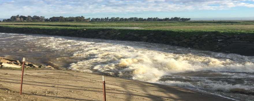
“We knew we had a serious problem and it was one we had to address if we wanted to continue the sustainability and longevity of the farm,” he said. “As a farmer, watching several million acre-feet of water pass along our western boundary that borders the north fork of the Kings River on its way to the ocean, that water quickly got my attention. So in 1982-83 which were big water years, we set up a diesel pumping unit as our first step in capturing floodwater, and our goal at that time was to use the water in-lieu of groundwater pumping. It was a better quality and we felt it would provide a lot of benefit and save the groundwater for uses for when we needed it later.”
“As the water flows down the north fork of the Kings River, the James Weir is the final diversion point for units on the Kings River so that water passing the weir essentially doesn’t have any rights associated with it other than the pre-1914 rights that KRWA had acquired,” he said. “It goes on a little further and joins the San Joaquin River and creates a lot of issues during flood years for flooding downstream.”
 The graph shows the high variability and frequency of magnitude on the north fork of the Kings River measured at James Weir. “It shows that when water flows, when we have flood years, we lose a lot of water that could remain within our basin. The median flow is 187,000 acre-feet per year when it does flow.”
In the past, people were reluctant to build infrastructure for a flow that is so variable; the infrastructure is expensive and floodwater didn’t have a lot of value to most people.
“But now that SGMA’s come along, everything’s changed,” said Mr. Cameron. “With SGMA, you have two choices. You’re either going to farm less ground or you’re going to do groundwater recharge. That simplifies SGMA down to those two choices. Nobody wants to have the State Water Board coming in and dictating how they are going to manage their aquifer.”
Climate change is going to make things worse with fluctuations in temperature and storms and more extreme climatic events. “We’re going to see different flows, and we know this will affect what we do in our farming day to day,” he said. “We’ve already seen changes during the summer in some of the crops that we grow. We’ve tended to move some of them away from the midsummer and into the shoulder periods to get away from some of the heat that we’ve seen.”


He presented a contour map of the groundwater basin (upper, right), noting that the blue arrow is pointing to a cone of depression, which is the deepest location. “We have a cone of depression caused by overlying farmers like myself that pump groundwater for irrigation to grow crops,” he said. “We also have an irrigation district to the west of us that has a 1919 easement through the area that allows for pumping of groundwater to be transferred over to their district to the west. In some years, they don’t pump any and there is floodwater available, but then during other years like what we saw during the five year drought, there was over 160,000 acre-feet drawn from the aquifer in addition to the farmers that pump the water here.”
Their groundwater subbasin is overdrafted around 125,000 acre-feet; their GSA is responsible for about 90,000 acre-feet of that overdraft, Mr. Cameron said. Their aquifer has a Corcoran clay base around 550 feet; the aquifer is currently around 240 feet; they think they can store 2.6 MAF in the space that’s within the aquifer.
 In 2010, Mr. Cameron received a $75,000 Conservation Innovation Grant from the NRCS that was matched with $75,000 from Terranova Ranch to implement the project to prove the concept that they could do on-farm aquifer recharge. They were ready in February of 2011 and began by bringing the water on the farm through the existing system and flooded fields for two months. They then let it dry down and turned around and planted a crop of processing tomatoes in late March.


“The yields were great and we had great infiltration,” he said. “Also as part of our project, we did salt monitoring for movement and also nitrogen management. We know that you’re going to have to have best management practices in place when you’re going to do any type of project like this.”
 “What really made us famous was when we started flooding our wine grapes,” he continued. “Traditionally, most growers don’t like to see their grapes underwater among other crops, but I felt confident. We put water on these fields for over 5 months, starting in February and ending in late June. We found that we could actually move quite a bit of water into these vineyards. Our neighbor thought we were a little crazy.”
Mr. Cameron recalled how back in 1992-93, the San Joaquin River flooded, and there was a vineyard that flooded with only the top foot of the vines out of the water for six months, and that vineyard suffered no permanent damage, so he figured he’d give it a try.
“What we found out was that once the air temperatures warmed up into the mid-90s, the water ended up warming up, and what I think happened is we lost oxygen content in the water and the vines turned a bright yellow. We pulled the water off because we didn’t want to lose the vines, and ten days later, these vines turned a dark green again and we had a normal crop harvested in mid-August, so we proved that year that we could do it.”
In 2012, they received a Floodwater Corridor grant from DWR to take water off the river so help reduce flooding downstream in the small communities that border the river. They turned it into a groundwater recharge project. It began as a $5 million grant from DWR with a $2 million match which would come from the sale of easements for flooding, so there are permanent flood easements on part of their property now, and the $2 million went back into the project, he said.
“We started in 2012, and we didn’t start building the project until the fall of 2018,” he said. “We had CEQA, we had permitting, we had agreements, engineering, and what started as a $7 million is now ramped up to be an $11.5 million project that we are responsible for funding the shortfall. We did enter into a 50-year agreement with KRWA to receive floodwater for the project.”


 The project has been broken into three phases with the first phase being 5500 acres in the center of their operations. They have constructed new headgates, a pumping station, and a canal; they are going to extend to the east and the north and add ponding basins at the upper locations and on the east side.
The system they started with in 2011 was pretty rudimentary; it could convey 17 cfs as best, he said. The new headgates have capacity for at least 500 cfs, so it has the capacity the convey 1000 cfs through the system.
In 2017, they flooded their pistachios and almonds, as well as open fields prior to planting.


They have monitoring wells in place with remote sensors so they are now monitoring water table elevations and are working on phase 2. By the time they finish phase 3, they will be recharging on 18,000 acres.
“The real issue that I see is where we have the worst overdraft issues, we don’t have infrastructure, we don’t have water deliveries, and we haven’t had irrigation districts, so it’s the white areas and the districts like the two that I’m in that never had water rights so they never had infrastructure to send water down their areas,” Mr. Cameron said. “Just going through what I’ve done in the last six years, if we don’t do this, we’re going to see our local communities suffer, jobs are going to be lost. Land values in our region have already dropped around $10,000 an acre due to SGMA. We think that the towns are going to be pretty much devastated in these local rural communities.”
DR. LAURA FOGLIA: Pilot study on the Cosumnes River
Dr. Laura Foglia is an Assistant Adjunct Professor at Department of Land, Air, and Water Resources at UC Davis, and she discussed a pilot study that is underway on the Cosumnes River. The project started as an Integrated Regional Water Management grant which had to be reconfigured because the original idea didn’t work; instead of building a reservoir, they are now doing more winter flooding on vineyards.
 The water district they are working with, the Omochumne-Hartnell Water District, is split between two basins for SGMA; the northern portion is in the South American Subbasin, the southern part is on the Cosumnes Basin. They are dealing with the development of two Groundwater Sustainability Plans, so this project could potentially have some benefits to both basins. The project has many partners, including the Cosumnes Coaliton and The Nature Conservancy, the UC Cooperative Extension, Sacramento State and UC Davis.
The project began in 2012, but due to permitting and funding issues, actual construction started just this month (March, 2019).
There are a number of questions about the project. Where is the recharge going? Is it flowing towards Sacramento so only the city is getting the benefit? Is the recharge water staying in the District? Is it flowing under the Cosumnes River and flowing into the Cosumnes subbasin? The question is how much water is providing to the different basins because the farmers want to be recognized for what they are doing, she said. They are also looking at the potential impacts to crops.
Of course, they want to know how much water, but Dr. Foglia said there is no way she would give them a number right now. “If I give them a number of possible recharge to one basin or the other basin, I will have to live for my entire life with that number, even its wrong,” she said. “So I told them, let’s put together a really careful implementation of data collection and models so we can really demonstrate what’s happening. A lot of environmental organizations are interested in what happens in the Cosumnes, so it would be good to show them we are benefitting not only the groundwater, but also benefitting the river later in the season.”
 The study is designed to be as comprehensive as possible; construction is currently underway. They are doing continuous groundwater monitoring, ET and plant stress monitoring as well as an extensive modeling effort. There are already models available for the area, but the idea is that to really be able to understand the local conditions, the models need to refined for the specific area, she said.
“We want to understand the benefits to the aquifers and to the river, and in the Cosumnes River, there are a lot of groundwater dependent ecosystems, so it’s important that we can show some kind of benefits for all the components of this system,” Dr. Foglia said.
 There are two vineyards totaling about 1000 acres that are being used as recharge sites and are shown in light blue and green on the map. They are working with the landowner to reach agreement on the property shown in orange. The fields are located between the Cosumnes River and Deer Creek; the Folsom South Canal is basically through in the middle between them. Farmers have done some infiltration testing and have demonstrated high numbers. The fields all have the facilities to pump water out of the Cosumnes River, so when the water is available, they flood their fields over the wintertime. Their permit allows them to divert water only between December and February.
The project is designed to work for the next ten years so they can develop a long-term picture of what is happening with the crops and the groundwater. They will begin with diverting at 4000 acre-feet per year, but the system is designed to divert up to 6000 acre-feet.
 They did a study on the historical flows on the Cosumnes River demonstrate that the water is really available most of the years. “We found out that 50% of the water years have enough flow in the river to allow the full 6000 acre-feet diversion, and 70% of the water years would have at least 4000,” Dr. Foglia said. “We are still debating with the State Water Board and still discussing about how much water, what’s the trigger, for deciding when we can divert the water so we don’t create any troubles to the ecosystem in the Cosumnes River.”
They are doing a lot of groundwater monitoring to measure the baseline conditions so they will be able to demonstrate what’s happening before and after. They have installed the four new groundwater monitoring wells in the area of the recharge site, and with the existing monitoring wells they will have ten locations with continuous groundwater level and temperature measurement. They are also including some electrical conductivity in some of the sites with the idea to use the electrical conductivity as a tracer. The plan is to make all of the data available to the farmers, and eventually available to the public online.
 There is also a larger UC Water monitoring network in the basin. The blue dots are the wells onsite where they are doing recharge; the red dots are wells in the Lower Cosumnes, and the yellow dots are wells that are being considered. Once completed, it will give a full picture of what’s happening, she said. They also have support from UC Santa Cruz as well as Lawrence Livermore Labs and Sacramento State, who have helped with installation of monitoring systems.
“The expectation is really that we can demonstrate with all this monitoring and all the data that we are collecting that we are just improving the quality of groundwater, that we are increasing the quantities, and the storage is increasing,” Dr. Foglia said. “We really most need to be able to answer the question about how much water and where it is going, so they can avoid future SGMA debate between the two basins.”
They are also working on groundwater modeling that will help them doing modeling of future scenarios. “With all the data we are collecting, we believe we will able to have a reliable calibration and we will be able to have a model that we can use for the future,” said Dr. Foglia. “What we really want to do with the model and the data is to try and understand the heterogeneity of the area and understand how this is really impacting the recharge rate, so at the end of the day, we can come up with for the entire Cosumnes River corridor with some kind of understanding of where to do it and how much we can recharge. I believe combining the model and the data that are we collecting, we may have a good argument to give some motivation to the stakeholders to do this type of recharge.”
FOR MORE INFORMATION:
 DISCUSSION HIGHLIGHTS

Commissioner Joe Del Bosque asks Dr. Laura Foglia about how fast groundwater infiltrates. “One thing about groundwater storage that is challenging is that you have a lot of water and you can’t store it as quickly as you can in above surface storage. How fast typically does water infiltrate into the basin? I know it’s going to vary a lot, but what’s the range like?”
Dr. Foglia said their instrumentation has just been installed, but the farmers in the past couple of years have measured about one foot per day without problems. “The idea with what we did right now is that the instruments that have been installed for measuring infiltration are really all distributed so we will have a better distribution and a better understanding of which are the best locations. It really depends on the soil. The reason we figure that this project was a good idea in the Cosumnes, really in the corridor between the Cosumnes and Deer Creek is because the farmers that did their preliminary study, they measured this rate of infiltration, they don’t expect even with the amount of water we are talking about, 4000 acre-feet per year, they don’t expect the water being ponding for many days.”
 Commissioner Del Bosque asks Dr. Dahlke about suitable soils. What’s suitable, what’s not suitable?

“The Soil Agriculture Groundwater Banking Index decision support tool that I had presented is using publicly available NRCS soil survey data,” replied Dr. Dahlke. “It’s considering five factors in the decision making. It’s using a factor called deep percolation, which is looking at the hydraulic connectivity of any soil layer in the soil profile; it’s looking at whether or not soil is deemed to be more prone to waterlogging or not; some chemical limitations are considered, such as whether or not a soil has naturally high salt content, salts which we don’t want to leach; also surface features such as whether or not the soil is prone to develop soil crusts; and then topography is the other factor, because we can’t really bank water on a slope. It’s mainly considering the upper 6 feet because that’s what the soil survey is looking at, so whatever happens underneath that is largely unknown.”
Commissioner Del Bosque asks about the depth of the existing water level. In some places it is 10 feet, in others it’s maybe 500 feet. Does that make a difference?
 “The water table depths is definitely something we are considering in our identification of primary locations,” said Dr. Dahlke. “The soil agricultural banking index, for example, excludes areas where the water table is within 10 feet of the soil surface, mainly because the alluvial aquifer that we have in the Central Valley, the sediment has air space in between, so we’re talking typically 10 to 30% of one foot soil depth, 20 or 30% of that can actually be filled with water, the rest is occupied by solids, so if you plan on putting 10 feet of water where you need 30 feet of space for that, roughly.”
Commissioner Del Bosque asks Don Cameron if he was storing water above the Corcoran clay.
“Yes, almost all of our wells are above the Corcoran clay,” said Mr. Cameron. “They are usually drilled to a depth of 550 or 600 feet; most of our water table is around 240 or 250 currently and continuing to drop. The water quality is fairly decent. We have a salt plume from an oil field to the north of us, but overall it’s acceptable for the crops that we grow now. Years ago, we grew cotton, alfalfa, and grain. We’ve changed; we really don’t grow any of those crops anymore, except for transitional to organic.”
Commissioner Del Bosque notes that for his colleagues, the Corcoran clay layer is an impervious layer down below where water infiltrates down to and then it stops and it starts to back up. “In some places, like in my area, where the water quality is extremely bad and we actually have to drain some of that salty water out of that area.”
“To the west of us as you get into Westlands, the water above the Corcoran clay is pretty poor,” acknowledged Mr. Cameron.
Commissioner Del Bosque asked, “What do you think would happen if they were to introduce a program like this. Would it make the problem worse?”
“In our area, we’re looking at improving water quality with the water we’re putting on, so long-term I think we’re going to have the benefit of better water quality and a higher water table with less pumping costs,” said Mr. Cameron. “Just a real win.”
“Would some of those areas like that be good candidates for this sort of program, in places where perched water tables a poor water quality?” asks Commissioner Del Bosque.
“I think it would depend on the conditions as the geological conditions are really important,” said Mr. Cameron. “We just happen to be in a more or less kind of an ideal area. Unfortunately it’s pumped to be a cone of depression but the other side of that, it gives us a large area to refill and not have it leave, so I guess we’re fortunate in that respect, but in a lot of areas where you have nitrate issues, where you have chemical issues in the water, if you do recharge in the right location, you can dilute it and actually improve water quality too which is going to help the communities as well.”
Commissioner Del Bosque asked about flooding the grapes. Was that constant or did you find that it’s better to do it intermittently?
 “We tried to keep it on consistently as there was no research, there was really no data that we could really fall back on,” Mr. Cameron said. “We just watched it and the vines grew; it was like a hydroponic situation and hey continued to grow. When we started seeing some yellowing once the temperatures changed, it got our attention real quick and we shut the water off, but we learned a lot. We even did olives for olive oil, which I thought they really wouldn’t be very tolerant of it, but they actually came through it in good shape. We tried a lot of different things. We took a lot of risks but we were careful to watch what we did.”
Commissioner Del Bosque asked about the challenges of expanding this program. “A year like this when we have a lot of storm flows, it would be great to get it anywhere we can. What are the challenges? Are there regulations or permits, what could we bring to our forum to alleviate these sorts of projects?”
“Money is always an issue for growers,” said Mr. Cameron. “Margins are difficult and tight in farming. The motivation is there, but I think a lot of time the permitting for putting something like this together on land that’s already being farmed, it really shouldn’t have a lot of environmental issues if it’s working land in production. Some of the temporary permitting with the State Water Board is difficult and it just seems like we should be able to simplify that process. I know they have their criteria for when you can take high peak flows, and it’s very limiting. The Kings River will flow from February to July because it’s based on snowmelt rather than just a storm that comes through during a particular period, so I asked them if they could look at each individual watershed separately and have recommendations for watershed development and permitting. The permit is needed to bring in the water, that’s difficult.”
Kamyar Guivetchi notes that the white paper lays out about a dozen topics that have been identified as challenges, so it’s not just one. “It depends on the scale of the activity. There’s no challenge that should prevent us to proceed today, so on farm recharge using high flows has been and can be done and we should proceed. We should also keep our eye on expanding the footprint and get to the watershed scale but that’s going to take more investment of time and more cooperation. What’s motivated us to put this research advisory committee together is to really get a better handle on where we should invest to get the additional information to overcome those challenges. We (meaning the larger community) have been working with the water board to see how we can improve and streamline the permitting, and the water board is considering options. Once this R&D plan comes out, we’d be happy to come back as a community and present the high leverage recommendations of the committee. That would be a good context to start thinking how could the Water Commission, the Flood Board, and the Food and Ag Board all begin to work together to advance state policy, state investments and state actions to help scale this up. Working at the farm scale, individual farmers, that’s great, we should do it, but it’s not going to really help GSAs and their constituents address what SGMA wants.”
Mr. Giuvetchi said that it’s also about flood risk reduction. “Given the climate dynamics, we are going to have and continue to have higher flood risk in the system that we have today, so we can certainly build bigger levees and more hardscape, and that may be part of the solution, but Flood MAR needs to be a big part of how we manage our flood risk because it also supplies water supply reliability and it will give us ecosystem benefits. It’s a win, win, win for California. It’s my personal opinion, it’s not the silver bullet, Flood MAR will not solve all the state’s water problems, but it will help broaden the water portfolio that we have.”
Commissioner Ball asked about the age of the trees. “I worry that when you start to flood a young tree, you’re going to promote shallow root growth that is then going to lead to the necessity to start pumping and flooding irrigation. We’ve done so much to try to get crops onto drip irrigation, so talk about the procedures you would need to take to ensure that you have a healthy tree that has deep roots and is going to be able to utilize drip irrigation during the summer months.”
Mr. Cameron agreed with Commissioner Ball. “When you have young trees, you have to be more careful and more diligent. You may be able to do periodic flushes of water and then let it move down, because they don’t have the root structure and they are more susceptible to root damage. … You have to be careful with it, because you do want to develop a good root system for the trees.”
 Commissioner Baker asked about the impacts of Flood MAR downstream. “If we did all this groundwater recharge in the Central Valley, both north and south, does that have any impacts on the flows going out of the Delta and out through San Pablo and San Francisco Bay? Because I’m imagining that you have to have some minimum flows going out so that those habitats don’t collapse.”

Kamyar Guivetchi noted that the slide with the graph from the AFR report looked at those high peaks. “Flood MAR is really looking at the water at the very top of these peaks, and with climate change, those peaks are going to become even higher, so from a mathematic perspective, yes when you take some of those highest peaks off, it will affect the water going out the Delta, but at that point in time, there are no control for water quality or other conditions. The system has more water than can be managed, so that’s part of this information and R&D plan is what is the balance, because one of the concerns of those who want to protect aquatic resources is making sure we don’t go overboard and take too much water out of the streams at critical times.”
“The other thing which is important to the community is keeping baseflows in the streams in the dry times,” continued Mr. Guivetchi. “With SGMA and Flood MAR, one can imagine an environmental water account under the ground where during these high flow periods, the state and feds could pay landowners to bank some of that water for environmental purposes, so that during the next dry period, rather than diverting water out of the stream, they could do in lieu recharge, use that water and keep the water in the stream for the fisheries which is when they’re most stressed. And as the groundwater basin levels rise, they get reconnected to these river systems and the base flow is increased, so that’s the balance we’re going to have to look for.”
FOR MORE INFORMATION …
DWR Resources on Flood MAR:
- Flood-MAR Fact Sheet
- Flood-MAR White Paper
- Draft Research and Data Development Framework
- DWR’s page on Flood MAR
UC Davis Decision Support Tools:
- Access the Soil Agricultural Groundwater Banking Index by clicking here.
- Access the Streamflow Availability for Recharge Rating tool by clicking here.

 Sign up for daily email service and you’ll never miss a post!
Sign up for daily emails and get all the Notebook’s aggregated and original water news content delivered to your email box by 9AM. Breaking news alerts, too. Sign me up!
