
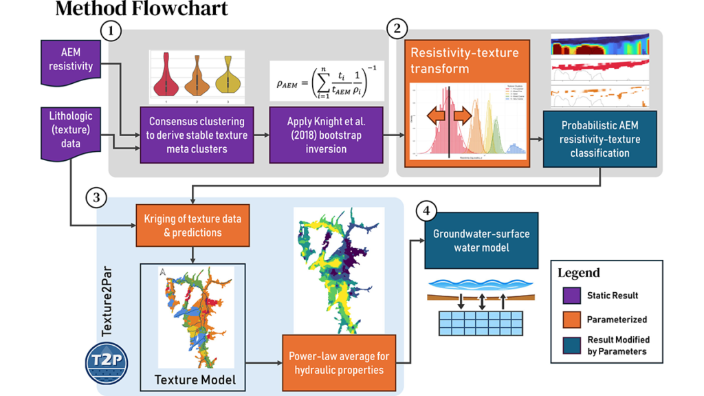
Scientists present a probabilistic framework for exploiting airborne geophysical data for groundwater model parameterization and apply it to the Scott River aquifer system in Northern California.
By Andrew Binley, EOS
Groundwater models are fundamental for tackling a wide range of water resources problems but are inherently challenging to parameterize due to the sparsity of subsurface data. Geophysical data can help address this by providing proxy measures of hydraulic properties, potentially offering a spatially rich dataset. There is growing interest in using airborne geophysical surveys for this purpose as they can provide insight into the spatial heterogeneity of an entire aquifer system.
Scantlebury and Harter [2026] offer a novel approach for deriving hydraulic structure models over large spatial scales from the integration of airborne geophysics models of subsurface electrical resistivity and borehole data, recognizing the uncertainty in resistivity-lithology relationships. The derived structures can then be incorporated into a groundwater model, as demonstrated by the authors in an application to the Scott Valley aquifer system. Such a workflow could improve significantly the utilization of large-scale geophysical data for reducing groundwater model predictive uncertainty.
RESEARCH ARTICLE: From Resistivity to Hydraulic Properties: Calibrating a Groundwater Flow Model by Integrating Airborne Electromagnetic and Borehole Data Into a Probabilistic Multi-Texture Framework
By Leland Scantlebury, Thomas Harter
 ABSTRACT: Airborne electromagnetic (AEM) surveys offer rapid, cost-effective subsurface imaging, yet converting their electrical resistivity (ER) models into physically meaningful hydraulic property fields for groundwater models remains a challenge. We develop and demonstrate a data-driven workflow for an unconsolidated sedimentary aquifer system in Scott Valley, northern California, USA, that incorporates AEM ER data with borehole logs to build and calibrate a geologically heterogeneous groundwater-surface water model.
ER and texture observations are first combined through consensus clustering into five meta-texture classes; a probabilistic ER-texture transform then converts ER data to cell-scale texture probabilities. These probabilities and borehole data are combined using Texture2Par to create a three-dimensional texture model, which is translated to grid-scale hydraulic conductivity and storage via power-law averaging. During calibration, we parameterized the ER-texture distributions, essentially allowing parameter estimation to adjust the estimated textures along the AEM flight lines. The texture-based groundwater-surface water model attains the same high goodness-of-fit as the previous zonal calibration (Fort Jones streamflow Nash-Sutcliffe efficiency = 0.84; groundwater heads r2 = 0.98), with more geologically plausible heterogeneity and improved simulation of groundwater-driven seasonally low streamflow. The proposed ER-to-texture workflow provides an adaptable workflow for embedding AEM information into basin-scale groundwater models.
PLAIN LANGUAGE SUMMARY: Groundwater models are commonly used for water management, and these models depend on accurate characterization of aquifer structure and its properties. Helicopter-mounted sensors that measure subsurface electrical resistivity provide a fast, relatively affordable scan of the subsurface, but converting these measurements into the hydraulic properties that control groundwater flow is not straightforward.
We tested a new method in Scott Valley, northern California, USA, that links resistivity estimates and sediment textures using a clustering method. This relationship allows us to convert resistivity into texture classes and merge them with the well log textures to estimate their distribution throughout the valley. We then estimate hydraulic properties for each texture by adjusting their values until the groundwater model matches historical streamflow and groundwater levels.
Although overall model calibration statistics were similar to a previous, simpler model, the new approach better simulated groundwater-dominated low-flow conditions in the Scott River during summer. It also provides a more realistic depiction of subsurface sediment distribution because it integrates information from both well logs and geophysical surveys. The workflow uses publicly available airborne data and open-source software, making it easy to apply to other basins seeking to integrate borehole and geophysical data into a groundwater model.

