
The Colorado River’s next operating era is beginning under unusually difficult conditions. On August 21, the Department of the Interior issued the final agency actions for the post-2026 Record of Decision and the operating guidelines for 2027 and 2028. Rather than establishing a fixed operating regime for the next decade, the Record of Decision creates a framework for shorter-term decisions. The two-year guidelines set the rules that will govern operations at Lake Powell and Lake Mead. They arrive as the basin faces some of the most severe conditions in the modern operating record: 26 years of drought, combined storage in Powell and Mead at its lowest level since Powell’s initial filling, and a winter that produced record-low snowpack.
At the August meeting of Metropolitan’s Imported Water Subcommittee, Colorado River Policy Manager Shanti Rosset briefed committee members on the new federal documents and their implications for Metropolitan’s water supplies.
“This is not a planning exercise for distant risk,” Ms. Rosset said. “The new rules are beginning with both reservoirs already under substantial stress.”
The Record of Decision framework
The existing operating framework expires this year. That framework includes the 2007 Interim Guidelines, the Drought Contingency Plan, and key binational agreements that have provided much of the structure water users have relied on. Because new reservoir operations at Lake Powell begin October 1, Interior had to act even though the seven basin states did not reach consensus on a long-term alternative.
The Record of Decision establishes four principles for each set of operating guidelines adopted within the 10-year framework:
- Operations are to respond to actual hydrology.
- Protection of critical infrastructure at the dams comes first.
- The guidelines are intended to implement the 1970 Long-Range Operating Criteria while allowing temporary action in extraordinary circumstances.
- Interior will give priority to consensus recommendations when they emerge. The Record of Decision preserves a path for the states to reach a consensus agreement that may be adopted if the recommendation is consistent with applicable law and the framework.
In practical terms, Ms. Rosset said the Record of Decision establishes the overall architecture but leaves many consequential operating choices to be made through each two-year decision.
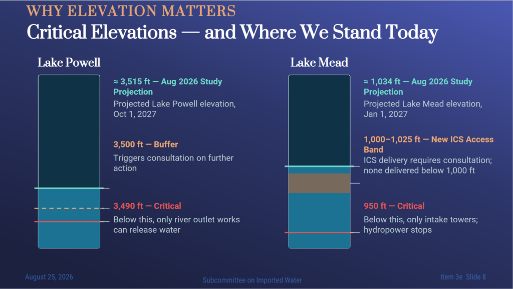
- For Lake Powell, the guidelines seek to maintain elevation 3,510 feet as the working target, with 3,500 feet identified as the critical reservoir threshold. Below 3,490 feet, releases can pass only through the river outlet works.
- At Lake Mead, 950 feet is the critical infrastructure elevation. For Metropolitan, the key range is between elevations 1,025 and 1,000 feet. In that range, delivery of Intentionally Created Surplus may be possible, but it is subject to consultation and may be reduced or denied if the delivery would cause Mead to fall below elevation 1,000 feet. No Intentionally Created Surplus may be delivered in a year when Mead’s January 1 elevation is below 1,000 feet.
The Record of Decision also defines the outer limits for future guidelines. Lower Basin shortages may be as high as 3 million acre-feet, and Lake Powell releases may range from 5 million to 12 million acre-feet. The framework also allows storage of up to 3 million acre-feet of conserved water in Lake Powell and up to 8 million acre-feet in Lake Mead, as well as limited surplus and voluntary Upper Basin contributions.
Ms. Rosset noted that these figures are sideboards, not automatic operating rules, and do not by themselves create an entitlement to store or recover water. Each future set of guidelines must select specific operations within those limits and comply with applicable law.
“For Metropolitan, that distinction is important,” she said. “A large Mead storage sideboard creates room for water management programs, but the terms governing creation, accounting, and delivery still have not yet been made concrete.”
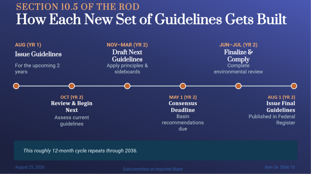
The framework then repeats the decision process approximately every two years. In the first year, Interior implements the current operating guidelines. In the second year, it evaluates performance, develops the next set of guidelines, and sets a May 1 deadline for consensus recommendations. If the basin states reach agreement, Interior gives that recommendation priority consideration. If they do not, the Secretary selects the next operations within the Record of Decision’s principles and sideboards.
The 2027-28 Operating Guidelines
The first operating period covers 2027 and 2028. For Lake Powell, the guidelines divide operations into three elevation ranges. The August 24-Month Study for water year 2027 places Powell in the low-elevation infrastructure protection range. Under that range, Reclamation begins with an expected release of 6 million to 7 million acre-feet and uses monthly modeling through April to maintain elevation 3,510 feet at Lake Powell. The final annual release is determined in April.
The guidelines also contemplate coordinated releases from the Upper Initial Units—Flaming Gorge, Aspinall, and Navajo—under a separate agreement among the Upper Division States and the United States. If that agreement is not reached, the Secretary will operate those reservoirs under existing authority.
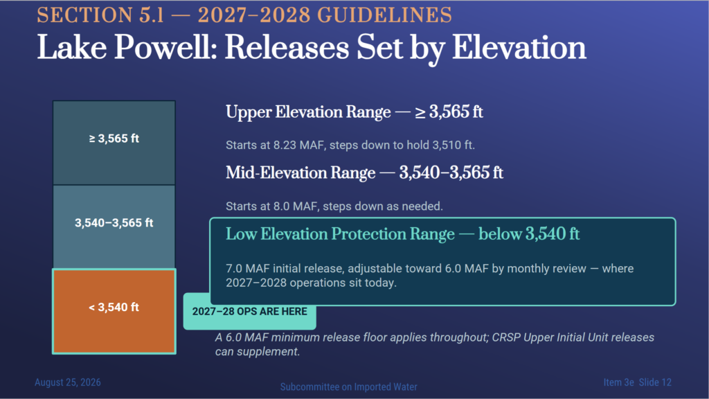
Ms. Rosset said the central change is that Lake Powell releases are now managed directly around infrastructure protection elevations, rather than around the 8.23 million acre-foot release objective alone. In ordinary operating ranges, the Powell release may be reduced to 6 million acre-feet; the broader framework contemplates releases as low as 5 million acre-feet in extraordinary circumstances. If a 24-Month Study projects Powell below elevation 3,500 feet through the following spring, the Secretary must promptly consult with the states, tribes, and affected parties on additional actions. Those measures would be temporary and would not amend the framework or establish a precedent.
LOWER BASIN OPERATIONS
At Lake Mead, Interior has already determined that a shortage condition will exist in 2027 and 2028. Under the guidelines, the amount available for consumptive use in the Lower Division states is 6.25 million acre-feet, which is 1.25 million acre-feet below the normal 7.5 million acre-foot Lower Basin allocation.
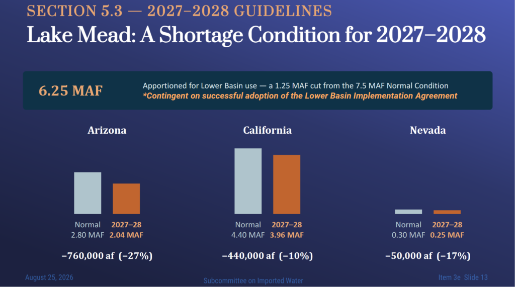
If the Lower Basin implementation agreement is executed, Arizona would receive 2.04 million acre-feet, California would receive 3.96 million acre-feet, and Nevada would receive 250,000 acre-feet. Those amounts reflect reductions of 760,000 acre-feet for Arizona, 440,000 acre-feet for California, and 50,000 acre-feet for Nevada. If the implementation agreement is not fully executed, the total shortage would still apply, but the Secretary would determine how that shortage is apportioned under applicable law. The guidelines also require consultation if Lake Mead is projected to fall below elevation 1,010 feet within the next 12 months.
Just for context, California’s basic Colorado River apportionment is 4.4 million acre-feet. Most of the water goes to the Imperial Irrigation District, and to a lesser extent, the Coachella Valley Water District, and Palo Verde Irrigation District, whose water rights are among the oldest on the river, and of a higher priority than Metropolitan’s. Metropolitan holds fourth-priority rights to 550,000 acre-feet and fifth-priority rights to another 550,000 acre-feet.
The guidelines also require 700,000 acre-feet of additional system conservation from 2026 through 2028, separate from the 1.25 million acre-feet in annual shortage reductions. This additional context comes from the Lower Division States’ May 1 proposal. In that proposal, the states described 700,000 acre-feet as the minimum cumulative contribution and set an aspirational target of at least 1 million acre-feet if sufficient appropriated funding is available. The proposal anticipated contributions of 300,000 acre-feet each from California and Arizona, and 100,000 acre-feet from Nevada.
Potential sources include existing conservation activities beyond those required for annual reductions, contributions of binational Intentionally Created Surplus and other stored water, and the new Lower Basin Conservation Program. The commitment was expressly contingent on adequate funding and a federal cost share.
Intentionally Created Surplus, or ICS
Intentionally Created Surplus, or ICS, is conserved Colorado River water that a state or contractor can leave in Lake Mead and later request for delivery under specified rules. Ms. Rosset highlighted two key points under the new guidelines: water already banked by contractors will continue to be honored and may be delivered through December 31, 2038, and contractors may continue creating new ICS through December 31, 2028, if the required agreement is completed. Without that agreement, the Secretary will deliver ICS created through 2036 under existing rules, but no new ICS may be created after December 31, 2026.
The slide below lists the numerical limits for ICS. California contractors may create up to 400,000 acre-feet of conserved ICS annually, accumulate up to 2 million acre-feet, and receive up to 400,000 acre-feet in annual ICS deliveries across the Lower Division states. Total ICS deliveries from January 2026 through December 2028 may not exceed 800,000 acre-feet. A one-time 10 percent assessment for evaporation generally applies when ICS is created, and remaining balances are reduced by 3 percent annually for evaporation.
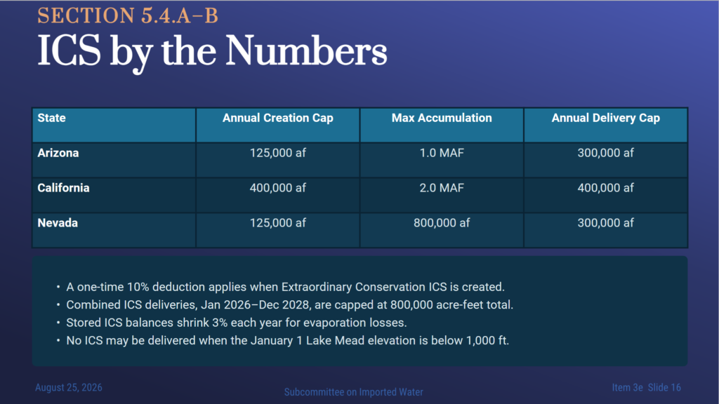
When Lake Mead is between elevations 1,025 and 1,000 feet, ICS delivery requests may require consultation. The Secretary may reduce or deny a request if the delivery would cause Lake Mead to fall below elevation 1,000 feet. If Lake Mead is below elevation 1,000 feet on January 1, no ICS may be delivered during that year.
Other provisions
Federal pool: The guidelines establish a federally managed water resources pool of up to 450,000 acre-feet of federally controlled ICS in Lake Mead for 2027 and 2028. The pool is used first to meet federal firming or other delivery obligations under congressionally authorized Indian water rights settlements. After those obligations are met, it may be used to offset up to 25 percent of qualifying Tribal shortages. Deliveries require federal agreements and count against the applicable state limits where they occur.
Mexico: Mexico remains on a separate legal and diplomatic track. Deliveries to Mexico are governed by the 1944 treaty and implementing minutes. Any reductions are determined through the International Boundary and Water Commission and are separate from the 6.25 million acre-feet available for Lower Basin consumptive use.
Environmental programs: The guidelines incorporate the new biological opinion and continue existing environmental and cultural resource commitments, including the Lower Colorado River Multi-Species Conservation Program, the Glen Canyon Dam Adaptive Management Program, and historic preservation requirements. Those obligations continue alongside the new reservoir operating rules.
Key takeaways
Interior’s final decisions move Colorado River operations from one long-standing set of guidelines to a 10-year framework built around shorter operating decisions, beginning with 2027 and 2028. Under that approach, Lake Powell releases will be managed around infrastructure protection elevations, the Lower Basin will take 1.25 million acre-feet of shortage reductions each year, and the guidelines call for 700,000 acre-feet of additional system conservation. The decisions also preserve important ICS tools, provided the necessary agreements are completed.
For Metropolitan, the immediate work will center on the Lower Basin Implementation Agreement and the California arrangements needed to carry out the 440,000 acre-foot reduction. Staff also will assess the protections needed for reliable access to stored water, the August operating determinations, and the parallel agreements required for upstream actions.
“The federal decisions are final,” Ms. Rosset said. “The work required to implement them is not.”
Turning operating guidelines into forecasts
Senior Engineer Laura Lamdin then described how Reclamation is incorporating the new operating guidelines into its forecasts.
The new guidelines have been added to the August 24-Month Study forecasts. Lake Powell’s operating tier is determined by the projected October 1 elevation in the most probable 24-Month Study. Under that forecast, Lake Powell is projected to be at elevation 3,515.8 feet, placing it in the low-elevation infrastructure protection range. In that tier, releases are set between 6 million and 7 million acre-feet for the next water year and are adjusted to maintain Lake Powell at or above elevation 3,510 feet.
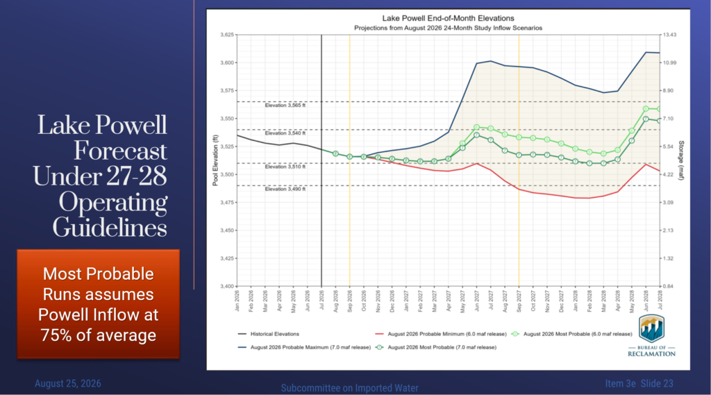
The slide shows the August 24-Month Study with the new rules incorporated. The graphic displays the full range of projected outcomes, including new minimum probable, maximum probable, and most probable conditions. In this context, most probable conditions mean inflows to Lake Powell equal to 75 percent of the 30-year average, reflecting the basin’s dry antecedent conditions. Minimum probable hydrology assumes conditions similar to the current year in overall inflows to Lake Powell. The August 24-Month Study included an evaluation of a 7 million acre-foot release from Lake Powell, showing the range of possible release schedules within the new low-elevation infrastructure protection range.
“What we can see is that even under the most probable conditions, under either release schedule, Lake Powell is expected to stay between elevations 3,510 and 3,540 over the next water year,” Ms. Lamdin said.
This tier is designed to adjust releases to maintain Powell above elevation 3510. That provides a 20-foot buffer to the critical elevation of 3490, which is Lake Powell’s minimum power pool level. If next year is just as dry as this one, the forecast shows that we would dip below that level around the end of next water year.
With Lake Powell releases between 6 and 7 million acre feet, Lake Mead is forecasted to decline significantly. Sometime over the fall or winter, Lake Mead is forecasted to decline below elevation 1035, the elevation at which power capacity at Hoover Dam is expected to be reduced.
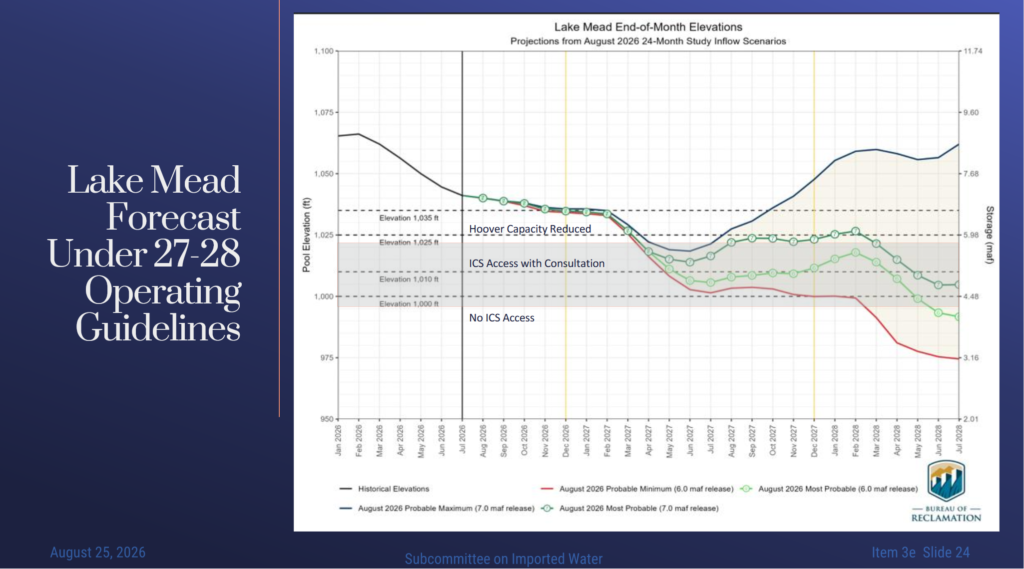
The next water year, Lake Mead is forecasted to fall below elevation 1025 under either a 6 or 7 million acre feet. This is the elevation at which ICS access would be restricted under the current 2007 guidelines DCP framework. However, under the new guidelines, we have access to ICS below 1025 down to elevation 1,000. With a 6 million acre-feet release from Lake Powell, Lake Mead is forecast to fall below 1010 in the summer of next year, which would be a trigger for reconsultation for potential additional actions.
“These results, while not unexpected, are very sobering,” said Ms. Lamdin.
Ms. Lamdin also identified several modeling assumptions that affect the forecast. Reclamation generally includes only actions that are known, contracted, and signed. As a result, the August 24-Month Study does not include all of the 700,000 acre-feet of additional conservation required under the new guidelines, because not all related contracts have been executed. It also does not include new California conservation actions to implement the 440,000 acre-foot reduction, because the intra-California agreements for allocating that reduction have not yet been completed. For modeling purposes, any remaining gap between projected California demands and the required 440,000 acre-foot reduction is represented as generic California ICS, without attributing the amount to a specific party.
“So while we know more now than we did, there are still some unknowns moving forward that will have impacts on the forecast and where exactly we end up,” she said.
Ms. Lamdin also addressed future access to ICS. Forecasts indicate that in 2028, Lake Mead may be between elevations 1,000 and 1,025 feet. In that range, ICS deliveries may still be available, but they would be subject to consultation with the Department of the Interior and could not cause Lake Mead to fall below the applicable protection elevation.
“So I would say 2027 we have access, and then 2028 is shaky,” she said.

