
Center for Coastal Climate Resilience finds mix of hard infrastructure and nature-based solutions offers best defense against sea-level rise in San Francisco Bay.
By Ashley Owen, UC Santa Cruz
Key takeaways
- Using sophisticated computer models to simulate complex, real-world dynamics, the new study finds that no single strategy can protect all Bay Area communities from coastal flooding—effective adaptation requires a mix of approaches tailored to local conditions.
- Nature-based solutions such as wetland and tidal marsh restoration emerged as especially promising, reducing water levels without unintended negative consequences.
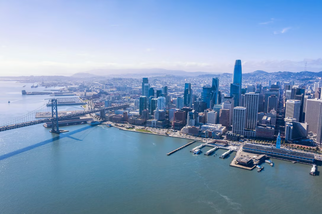
- With more than 100 cities and nine counties bordering San Francisco Bay, the research underscores the need for regional cooperation to address flood risks that will intensify with climate change.
Coastal communities around the world have long faced challenges related to flood risks. But as sea levels continue to rise and extreme weather events become more frequent, the need for more effective response strategies is greater than ever.
The San Francisco Bay is one such region experiencing this exact trajectory, making it a focal point for scientists like Patrick Barnard, research director for the Center for Coastal Climate Resilience at the University of California, Santa Cruz. Barnard co-authored a paper recently published in the ASCE Journal of Waterway, Port, Coastal, and Ocean Engineering that explores coastal flooding patterns and mitigation strategies throughout the bay region.
“This is a huge system and what we do physically affects very far reaches,” Barnard said. “Everything has implications and they have to be studied together to be understood.”
A prime region to research
Prior to relocating to Puget Sound in 2020, Barnard called Santa Cruz and San Francisco home for two decades while working for the U.S. Geological Survey and studying coastal hazards, climate adaptation, and resilience throughout the area. In 2019, his research detailed just how severe the region’s risks could be, stating that “over 400,000 residents and $150 billion in property could be exposed to flooding this century across San Francisco Bay communities, accounting for two-thirds of the coastal flood risk for California.”

For the new paper, Barnard and his co-authors built on existing collective studies to further examine future flood-risk patterns and viable adaptation tactics. Specifically, they set out to uncover how three different strategies—shoreline hardening, nature-based solutions, and subregional floodgates—would impact water levels within specific areas and across the broader region.
“For me, this really goes back 22 years of trying to understand this whole system—how beaches on the outer coast are affected by what we do in San Francisco Bay, what we do up the Delta, and what we do all the way up into the Sierras,” Barnard said. “It’s all connected.”
The team applied a numerical modeling exercise to understand how hydrodynamic processes shape spatial and temporal water-level changes in the San Francisco Estuary. They also worked to determine how different flood-reduction approaches may work against sea-level rise and storms projected over the next century.
Flood risk and the potential impacts on coastal communities in the region are compounded by a few factors. Much of the region is low lying, making it more vulnerable to climate change and rising water levels and storm surges. To add to that, more than 100 cities and nine counties border the bay, making it even more complicated to find solutions all agree on.
“It is a major challenge, but representative of the kind of challenges we have worldwide where no one can act in isolation and fix the problem for themselves,” Barnard said.
The results are in: variety is key
The team discovered that the answer to the bay’s flood risk is anything but one-size-fits-all. The findings point to a variety of methods implemented strategically across the region as the best way to adapt to future sea-level changes.
“No single strategy is sufficient for protecting every community. Especially in such a complicated area, it’s going to be a combination of interventions and adaptation solutions,” Barnard said.
Shoreline hardening, which is effective at reducing flood risk within a specific locality, was found to make water levels rise in other nearby areas. However, in some cases, shoreline-hardening methods are still the best option—like using sea walls to protect high-value, sensitive infrastructure such as a school or hospital located along the bay shoreline. On the flipside, local floodgates can lower surging water levels without outside effects; but these gates may be impacted by rising sea levels.
Nature-based solutions like tidal-marsh restoration were shown to reduce water levels without any unintended consequences. “Wetland restoration can actually provide a pretty significant benefit,” Barnard said. “Even a few inches of protection can make a big difference in how often flooding happens.”
In their study, the team found that wetlands can provide an estimated 20 centimeters of flood-risk reduction when implemented in key places in the Bay Area.
Looking ahead
Though much still needs to be done before the bay’s flood risks become a thing of the past, these findings can help all those involved—from scientists to engineers, governmental agencies, and other stakeholders—agree on solutions that will serve the entire region.
Beyond the bay, Barnard and his colleagues see this region’s response to rising sea levels as an opportunity to guide other coastal communities, while also reinforcing the benefits of emergent strategies like nature-based solutions.
“There’s been this movement toward nature-based solutions in recent decades, and that’s something the Center for Coastal Climate Resilience focuses on a lot,” Barnard said, “how we can use nature-based solutions to reduce risk for communities and also bring along the benefits of building with nature.”

