

Groundwater is a critical resource, supplying nearly 40% of the state with water to support cities and farms. With droughts increasing in severity and frequency and climate change putting stress on local communities across the state, it has become increasingly clear that California can no longer manage groundwater resources as we have in the past. This recognition led to the passage of the Sustainable Groundwater Management Act (SGMA) in 2014 – a law designed to provide statewide guidance for managing California’s precious groundwater resources sustainably. Eight years in, how is the implementation of SGMA going?
In a presentation to the Southern California Water Dialog, Ellen Hanak, vice president and director of the Water Policy Center and a senior fellow at the Public Policy Institute of California (PPIC), gave a status check on SGMA implementation with a focus on the San Joaquin Valley, which is ground zero for SGMA implementation.
In the San Joaquin Valley, bringing groundwater basins in to balance will necessitate significant amount of irrigated lands to come out of production. Ann Hayden, Interim Vice President of Climate Resilient Water Systems for the Environmental Defense Fund, discussed how the state’s Multibenefit Land Repurposing Program hopes to help with the transition.
Ellen Hanak: A status check on SGMA implementation
Ellen Hanak began by noting that the Public Policy Institute of California (PPIC) is a nonpartisan research organization that looks for pragmatic, cooperative solutions to the state’s big water and natural resource challenges, and implementing the Sustainable Groundwater Management Act (SGMA) is definitely one of those big challenges.
 The map shows the major groundwater basins in California. In Southern California, most groundwater basins are actively being managed and recharged and have been so for many decades. In the early part of the 20th century, with the increase in population came problems with overdraft, land subsidence, and saltwater intrusion. This led to adjudications of basins and the creation of special management districts, such as the Orange County Water District, which have special authorities to manage the basins. Also, Ms. Hanak noted that some of the groundwater basins on the Central Coast have also been adjudicated.
However, most groundwater basins elsewhere in the state were not managed, resulting in long-term overdraft, especially in agricultural areas such as the Central Coast and the San Joaquin Valley. The basins on the map shown in orange are considered critically overdrafted by the state and were required to develop and submit groundwater management plans to the Department of Water Resources by January 31, 2020. The basins shown in yellow are also subject to SGMA but weren’t considered in as dire of shape, so they had until January 31, 2022, to submit their plans.
 The Sustainable Groundwater Management Act (or SGMA) required the creation of local groundwater agencies to develop and implement groundwater management plans to achieve sustainability. A basin can have more than one GSA, but each land parcel can only be in one GSA. About 85 groundwater basins are subject to SGMA; some are quite big, and some are tiny.
SGMA requires a groundwater basin to be managed to avoid significant and unreasonable undesirable results, such as dry wells and land subsidence. SGMA also requires annual reporting and updates of the groundwater management plan every five years. The basins must reach sustainability by 2040 or 2042, twenty years after submitting the first plan. Ms. Hanak acknowledged that it’s a long time, but there was recognition that it would take some time to make the adjustments without a big shock to the system.
San Joaquin Valley in the crosshairs
The San Joaquin Valley, California’s largest agricultural region, is considered ground zero for SGMA implementation, as nearly all of its groundwater basins are critically overdrafted. Overdraft was estimated at 2 million acre-feet per year on average. The effects of the overpumping became apparent during the 2012-16 drought, when many wells went dry and infrastructure was damaged from land subsidence. SGMA was passed during that time.
“The big picture story in terms of the solution is that the basin can get to balanced by adding more supply or using less water (which is sometimes called managing demand), or some combination of both,” said Ms. Hanak. “Our analysis points to the need really to do both. We think that maybe you can deal with about a quarter of the deficit with cost-effective new supplies, and probably the rest has to do with demand management.”
“The economic problem with all of this is that some of the approaches and solutions are more costly than others, and that’s why some supplies might be feasible technically but not cost-effective – ocean desal is not going to work for supplying agriculture in the San Joaquin Valley even if it’s technically feasible to do it. So there are also different ways to manage demand; some are more costly than others.”
SGMA implementation: The good news and the bad news
So, there’s both good news and bad news, she said. “The good news is that in general, both in the Valley and across California, basins and the water users in the basins have met the early stage SGMA requirements and formed their GSAs on time. They, by and large, got their plans in on time. And that’s required a lot of work starting from almost scratch in terms of the kinds of data they have to build together. A lot of those plans are not bad at all; they are pretty good at meeting all the requirements. But in the San Joaquin Valley, it’s been a struggle on that score.”
The plans are submitted to the Department of Water Resources, which is responsible for reviewing those plans for adequacy and substantial compliance with the regulations. All critically overdrafted basin plans in the San Joaquin Valley were reviewed and deemed incomplete; those basins had six months to address the deficiencies and resubmit their plans. Ultimately, six of those plans were considered inadequate and referred to the State Water Board, which has the authority to put the basin on probation and take over management until the locals can acceptably address the issues. Probationary hearings on those basins could potentially start in December of this year.
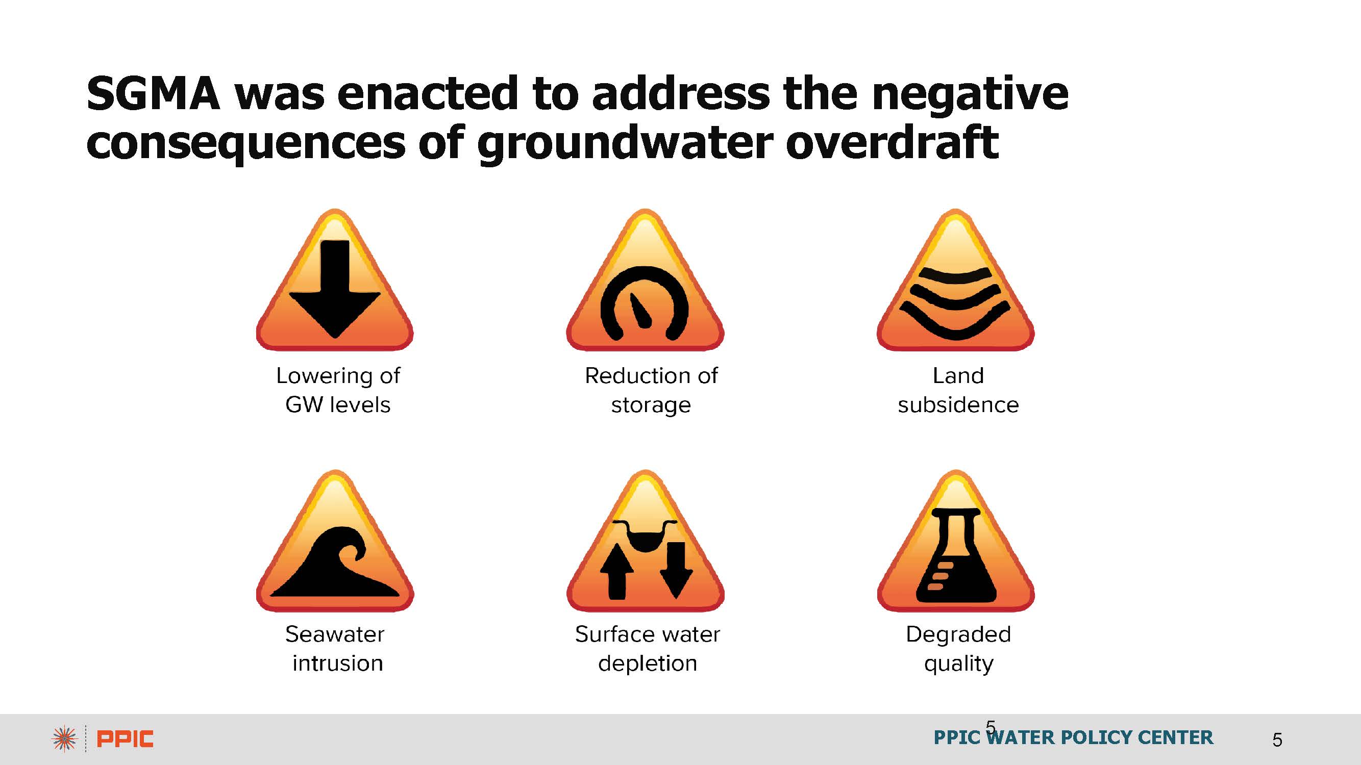
SGMA requires groundwater basins to be managed sustainably, defined in the legislation as avoiding the six undesirable results: lowering groundwater levels, reduction of groundwater storage, land subsidence, seawater intrusion, degradation of water quality, and depletions of interconnected surface waters. The Department of Water Resources cited inadequate attention to lowering groundwater levels and the impacts on domestic wells and not adequately addressing land subsidence as the reasons the plans were ultimately considered inadequate.
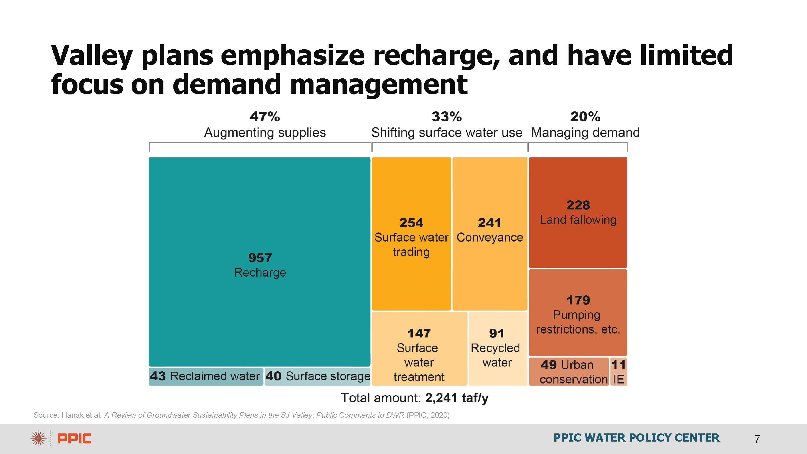
“The plans were extremely optimistic, in our view,” said Ms. Hanak. “Everybody wants to avoid land fallowing because basically, in an agricultural area, most of the water savings you’ll get will be from taking land out of production. But this is not something you can solve with irrigation efficiency. It’s only really by reducing the net amount of water that the crops are consuming. Some crop shifting can help, but mainly land fallowing.”
“The plans didn’t really do the math of where that water was coming from,” she continued. “They put a lot of emphasis on groundwater recharge, and that’s important to capture more flows from big storms. But that’s probably an overly optimistic number. And it was clear when you looked at all the plans together that folks were counting on the same drops of water to solve problems in different basins. This was also something that DWR flagged.”
“The potential hit to the agricultural economy was really large. We have done some updated analysis looking at the potential decline of water supplies on average by 2040, taking into account SGMA, plus some additional losses that might come from the changing climates and climate model predictions, as well as from new environmental flows that the State Water Board has proposed – you’re looking at up to 20% decline in annual water supplies, almost as much in terms of irrigated acreage, so up to about 900,000 acres of irrigated cropland that would be fallowed, 50,000 jobs lost, and about a 2.3% decline in total regional GDP from this reduced activity because of less water.”
Softening the transition in the San Joaquin Valley
Of course, GSAs would rather augment supplies than reduce groundwater use, but there’s growing recognition that demand management will have to be part of the story. So the PPIC has been studying ways to soften the transition using tools such as improving water trading rules, updating water infrastructure, recharging groundwater, increasing ag productivity, and finding productive uses for fallowed lands.
The chart below shows the decline in water availability for the San Joaquin Valley due to SGMA implementation. The first bar is water reductions due to SGMA; the second adds climate change, and the third adds environmental flows.

“That’s more than 3 million acre-feet of water that growers won’t be able to apply to their fields to get the kind of water savings that are needed to keep basins in balance, and the hit to Ag GDP that includes crop production, dairy, beef, and food and beverage processing could be quite significant,” said Ms. Hanak.
The additional bars on the chart below illustrate how water trading can significantly cushion the costs of reducing water supplies. Ms. Hanak pointed out that the reduction in applied water stays the same – the amount of water is not changing. However, with water trading, water can be moved around so that it goes to the most economically productive crops. Growers with high-value crops would want to buy the water, and growers with less economically productive crops would be willing to sell their water.
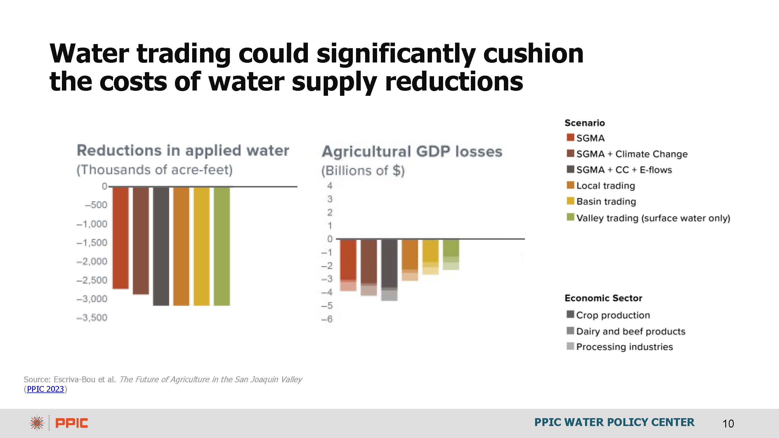
The colors of the bars indicate different levels of water trading. The brown bar represents inflexible management; water trading only locally with no flexibility. The yellow bar shows water trading within the whole groundwater basin. The green bar allows trading across the Valley where there is more surface water trading across basins; groundwater would stay within its basin, but surface water would move around.
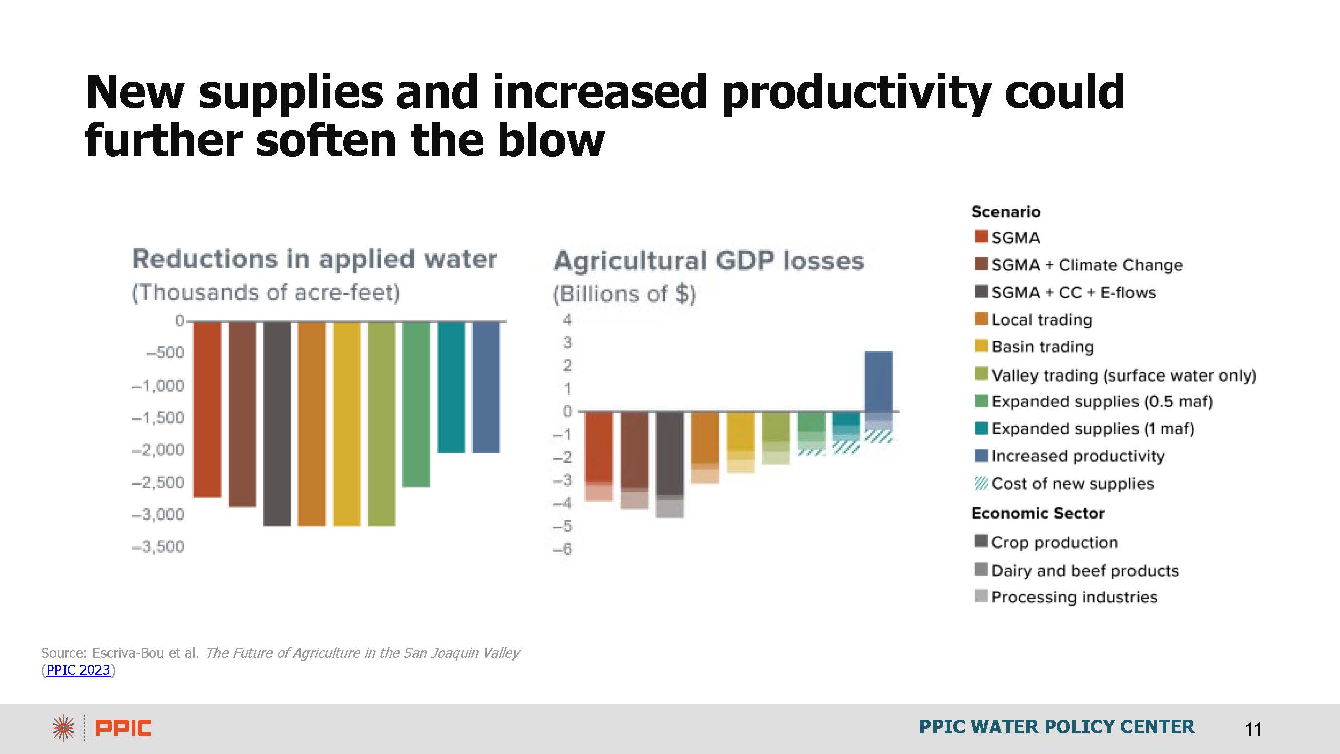
The last set of bars on the chart below show the additional economic value of adding new water and increasing agricultural productivity. “So there’s a good news story, which is that there’s a lot of innovative potential, and so folks will be innovating for sure and figuring out how to cope with shortages and the changing climate,” she said.
The set of graphics on the slide below shows how different levels of water trading would affect land fallowing. On the maps, the dark brown colors indicate areas with a high risk of land fallowing – more than 25%; gray areas have no risk, and the other colors are somewhere in between.
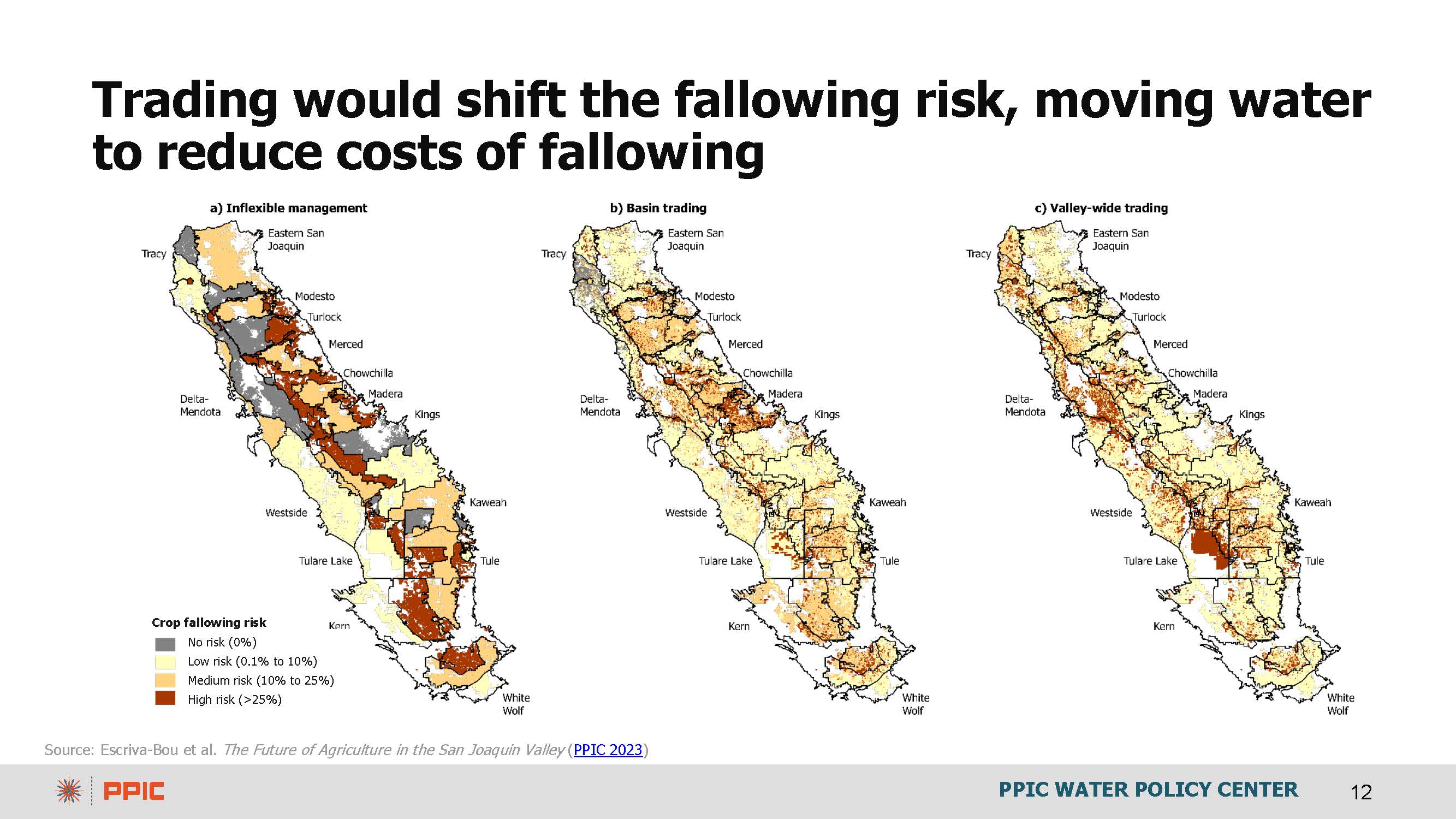
With inflexible trading rules, much land across the San Joaquin Valley is at risk of being fallowed, as shown on the map on the left. With basin trading, shown in the center, there is much less fallowing risk, and it is distributed across the Valley as water moves from alfalfa and field crops to perennials. With Valley-wide trading, depicted on the map on the right, the surface water moves out of some basins where conditions are unsuitable for higher-value crops and moves to other places.
The PPIC considered the opportunities for other productive uses for fallowed land. The map on the left shows the solar potential of the San Joaquin Valley, which is quite high. Solar installations would also bring jobs and help meet California’s clean energy goals. Ms. Hanak acknowledged the challenges in getting transmission into place, but it could be a win-win for the Valley.

The map on the right shows the habitat suitability for San Joaquin desert species based on work by the Nature Conservancy. Some basins, such as Kern County, have much more suitable habitat than projected fallowing.
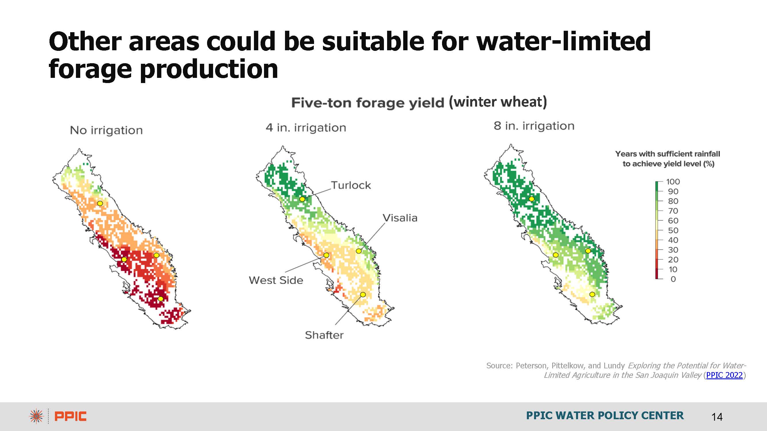
The PPIC also considered dryland farming for winter crops, using no irrigation water on the left and various amounts of irrigation to help with crop establishment as the graphic moves to the right. This work was done using winter wheat as a forage crop because there will likely be demand for increased sources of forage as alfalfa and irrigated pasture are likely to decline.
In conclusion …
“SGMA is key for the future, but it will shrink our irrigated agricultural footprint. Reducing water supplies in this way will call for both supply and demand side adaptations,” said Ms. Hanak. “There’s been a lot of innovation on the supply side this wet year. We’re seeing a lot of new kinds of recharge and some demand management experiments happening with allocations in some basins and the beginning of some groundwater trading, which is great. Careful management can soften the blow, such as flexible water use, trading, infrastructure and productivity investments, and incentives to productively repurpose the ag lands.”
Ms. Hanak pointed out these are looming issues across the West, especially in the Colorado basin, as folks must respond to dwindling Colorado River supplies. “California will not be able to stay out of that one. Even though we have the largest share of water and the most senior rights, our urban and farm communities will have to adapt, as will our partners in other western states. So some of these solutions in terms of innovation and management on the supply and demand side will be key there too.”
Reports from the PPIC on the San Joaquin Valley:
- Policy Brief: The Future of Agriculture in the San Joaquin Valley
- Solar Energy and Groundwater in the San Joaquin Valley
- Land Transitions and Dust in the San Joaquin Valley
- Exploring the Potential for Water-Limited Agriculture in the San Joaquin Valley
- Groundwater and Urban Growth in the San Joaquin Valley
Ann Hayden: California’s Multibenefit Land Repurposing Program Overview & Status Update
The Environmental Defense Fund is a global environmental organization that’s been around for over 50 years, addressing some of the world’s greatest environmental challenges. One of the areas that EDF focuses on is the arid West, where irrigated agriculture is the primary water use and where water scarcity is increasingly a pressing issue. EDF is working to develop replicable tools and multi-benefit solutions that build water and land resilience.
 The implementation of SGMA and the looming issue of water scarcity will significantly impact the state’s agricultural sector, with 750,000-1,000,000 acres potentially coming out of production as SGMA is implemented. The impact on the social fabric, the economy, the environment, and the air quality of the San Joaquin Valley could be significant.
If unmanaged, fallowed fields worsen already impaired air quality and host weeds and pests, impacting the remaining agricultural lands and marginalized communities. The cultural fabric of the San Joaquin Valley, which is tightly tied to agriculture, would also be significantly impacted.
But there is an alternative to just leaving fields idled: land repurposing.
 Multi-benefit land repurposing is the process of transitioning previously irrigated agricultural land to new uses that will conserve water and deliver a range of benefits to communities and ecosystems. The idea is here to reduce groundwater reliance and create local environmental and economic opportunities through changes in land use.
The possibilities include managed grazing, solar power, dryland crops, and recreational space. Groundwater recharge basins can be designed to recharge groundwater, create habitat for migratory birds, reduce flood risks to downstream communities, and improve water quality in drinking water wells. Habitat restoration is another possibility; currently, there are ‘islands’ of existing protected habitat, and a need to create more connectivity between them.
“The goal across all of these options is to help farmers to maintain cultivated fields where possible while also creating opportunities to repurpose fields and thereby reduce the economic impacts of this transition,” said Ms. Hayden.
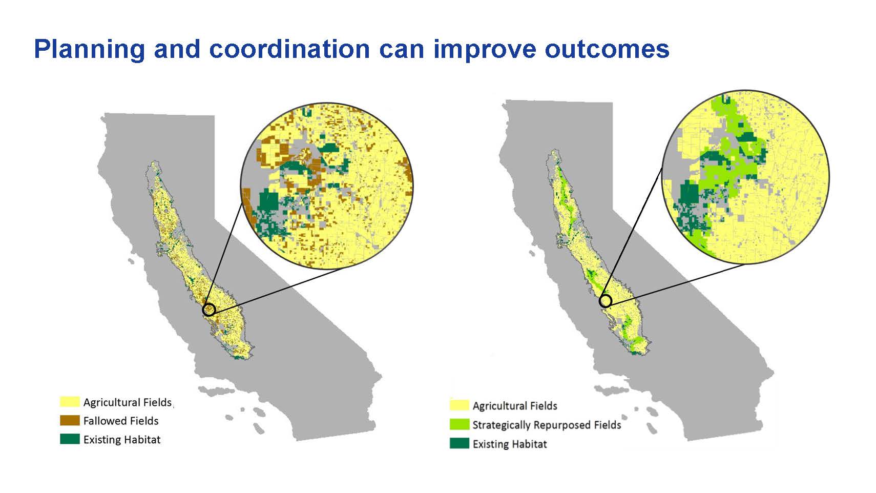 The slide gives a hypothetical example of how habitat restoration might play out on the landscape. The map on the left shows how fallowing might occur under inflexible trading rules; the fallowing is haphazard, creating a patchwork of fallowed fields interspersed among agricultural fields. On the map on the right, under flexible rules, the fallowing is more strategically located, working with farmers who would voluntarily repurpose some of their land that they no longer have water to irrigate and repurpose their land to create habitat adjacent to existing areas of habitat, shown in dark green.
“This type of repurposing EDF believes has the potential to really create a whole mosaic of new uses across the valley,” she said. “This should not just be about repurposing into one new use but a whole variety of uses depending on what communities want to see, what stakeholders want to see, and what is going to be most beneficial for the economy and public health.”
The effort to establish the Multibenefit Land Repurposing Program began about five years ago when EDF worked with legislators in the Valley to sponsor a bill to establish the program. They collaborated with numerous NGOs, water agencies, community-based organizations, and agricultural interests to design a framework for the program that could be broadly supported.
Ultimately in 2021, the governor approved $50 million to establish the multi-benefit land repurposing program at the Department of Conservation to provide funding for landowners who voluntarily can demonstrate a reduction in groundwater use and repurpose their lands for new uses that can create public benefits.
One thing EDF heard from the stakeholders was that the landowners needed flexibility in how the transition happens. Not every landowner will want to sign up to put an easement on their land and perpetually have habitat on these repurposed lands; many will be interested in a shorter-term commitment where they can experiment with some of the new uses. So the program intentionally allows the option of a minimum of 10 years for land repurposing as well as permanent land repurposing.
“This is really a companion program to the implementation of SGMA,” said Ms. Hayden. “SGMA is determining how folks will be ramping down their groundwater use and what allocations landowners will have. This program is here to help landowners have options about how they manage the land that they have with the water that they have.”
Program details
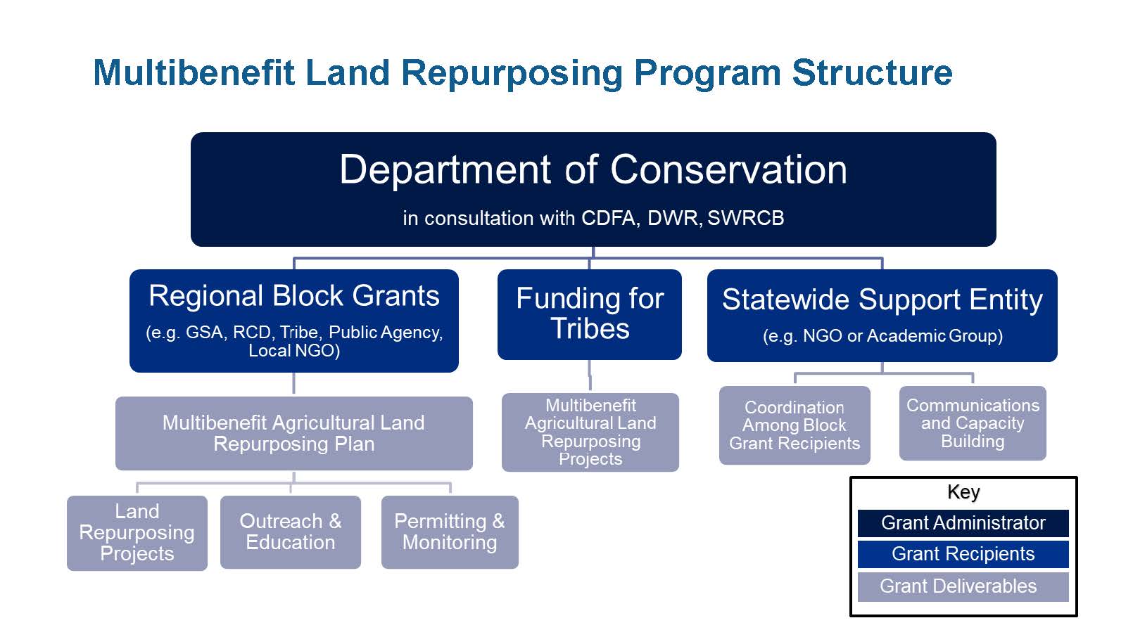 The Multibenefit Land Repurposing Program is housed with the Department of Conservation, which implements it in consultation with other state agencies involved in SGMA implementation, such as the Department of Water Resources, the Department of Food and Ag, and the State Water Board.
The goals of the MLRP are:
- Support coordinated, regional and basin-scale efforts to achieve groundwater sustainability
- Support long-term repurposing of lands and multi-benefit opportunities that convert land to less intensive water uses while maintaining natural and working lands
- Create or restore wildlife habitat and wildlife connectivity
- Support nature-based solutions to reduce the impacts of hazards on lives, property, and the economy from overdrafted groundwater basins
- Prioritize the achievement of disadvantaged community benefits
Local entities, such as groundwater sustainability agencies, resource conservation districts, tribes, public agencies, local NGOs, and land trusts are eligible to apply to the program, which can grant up to $9 million. Grant recipients are tasked with developing a plan for land repurposing, with a clear demonstration of partnerships and stakeholder engagement as a requirement.
Funding can be used for implementing land repurposing projects, facilitating outreach and education, or covering the costs of permitting and monitoring. Some funding has been set aside for tribes to participate in the program. The grant recipient also has some discretion to fund additional incentive payments for parcels of land that they might want to bring into the program. The program allows for both temporary and permanent projects.
Statewide Support Entity
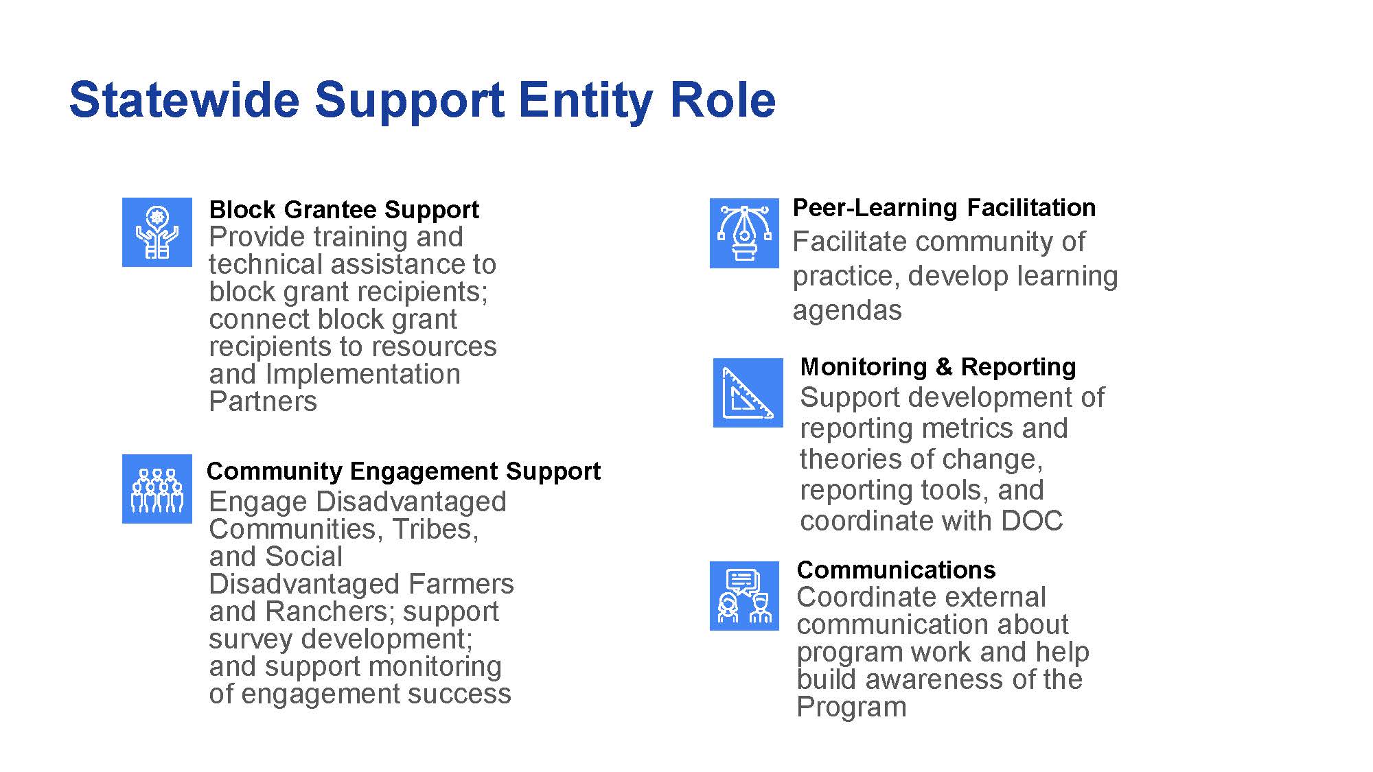 The program also establishes a new Statewide Support Entity to help with implementation, which EDF is co-chairing with Self Help Enterprises, a local community-based organization in the Valley.
“I see our role as creating a hub of the best available information on a whole suite of land repurposing strategies and to be a direct resource for the block grantees,” said Ms. Hayden. “We are also tasked with helping to shape community engagement for these block grants, ensuring that they’re bringing in voices from disadvantaged communities and socially disadvantaged farming and ranching individuals. We’re also helping to facilitate and a peer to peer learning and to create a community of practice.”
They are also tasked with developing the monitoring and reporting to measure and track the outcomes over time and communicating the success stories and lessons learned for others interested in repurposing land.
Grant awards to date
In the spring of 2022, 12 regions applied for funding, with requests far exceeding what was available. Four regions received $10 million each: The Lower Salinas Valley, the Tule Subbasin, the Kaweah Subbasin, and Madera County.
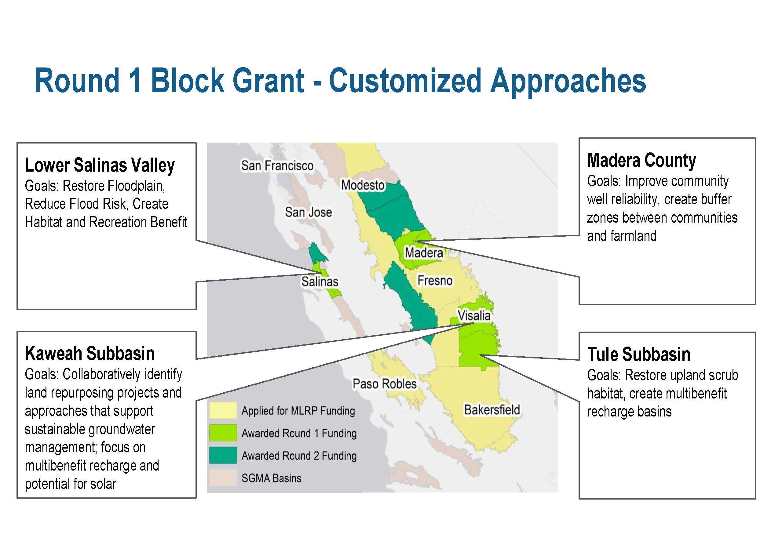 Another $40 million was made available in January 2023. Ten applications were received, and $35 million was awarded to four entities: Pajaro Valley, Westlands Water District, Merced Subbasin, and East Turlock.
Ms. Hayden noted that this program is not overly prescriptive. “The Department of Conservation really wants to allow for creativity, innovation, and customized approaches, so we’re going to see a variety of plan objectives included, from Madera really focused on improving community well reliability and buffer zones between communities and farmland to the Tule basin really focused on restoring upland scrub habitat and multi-benefit groundwater recharge basins.”
“As the statewide support entity, we will make sure that the block grant recipients are well aware of the full array of options that exists and that they are keeping their minds open about what’s possible in terms of what can be implemented on the ground to match the needs of the local communities,” she said.
Program principles
The principles of Multibenefit Land Repurposing Program are:
- Collaboratively developed programs
- Multi benefit outcomes
- Regionally-coordinated to maximize benefits
- Payments linked to benefits
- Permanent or reasonably durable projects
- Guaranteed demand reduction
- Monitoring and adaptive management
The MLRP gives a fair amount of discretion to the local entities implementing the programs, so they want to see collaboratively developed programs with a lot of clear stakeholder engagement that considers all the factors as land use change happens. They want to see multi-benefit outcomes achieved.
“We don’t want to be singularly focused on converting the Valley or any landscape to just solar, or even groundwater recharge for that matter. We really want to see a whole diversity of different benefits realized. There’s huge importance in a regionally coordinated approach to maximize benefits.”
“We want to see movement towards permanent repurposing of these lands, clearly with an eye on creating flexibility for landowners as they go through this transition. But we need to recognize that this demand reduction needs to be happening on a long-term basis, and we need to be smart about how we think about the long-term repurposing of these lands. To that point, we want to see guaranteed demand reduction associated with these projects, as well as clear monitoring and adaptive management.”
Going forward …
Ms. Hayden pointed out that there is more funding on the way from the state and possibly from the federal government.
- Multibenefit Land Repurposing Program, webpage at the Department of Conservation
QUESTIONS & ANSWERS
QUESTION: Other aquifers exist in the nation, such as the Ogallala in the Midwest. Where does California rate compare to the severity of the issues we’re trying to solve?
Ellen Hanak: “We’re not alone in having to manage our groundwater better. We were behind the curve compared to some of the other western states, but in some ways, we’re more resourced in terms of our ability to innovate, so I’m optimistic about our trajectory. But the Ogallala is a big one. That’s another place where the tools of thinking about how to farm differently or repurpose some farmland will be key. There’s a reason why there are long-term deficits of groundwater – it’s because demand exceeds supply. In ag areas, there’s land you could productively use the water on if you can pump it, so you need pumping controls. In California, we can take advantage of some of these high-flow events to add some water, but we won’t be able to fill the whole gap. That’s going to be true in some of the other regions of the West that have the same issues.”
Ann Hayden: “We’re paying a lot of attention to the places that are not quite where we are yet … there are stories and visuals of land subsidence and wells going dry … . Those stories are making it more into the headlines today. But places such as Eastern Oregon and Arizona are not too far off from heading to where California was pre-SGMA. We’re still impacting our groundwater basin as we speak, but at least we have a path towards sustainability charted out. We have plenty of places where it’s not too late for intervention if we’re really intentional and proactive about it.
QUESTION: How are farmers being compensated for the change in land use? How are they receiving the program?
Ann Hayden: “It’s in the early days of implementing the program. The first round of block grant recipients are still organizing themselves and making sure that they’re bringing in community interests as their land repurposing plans are being developed. So now is the time to be informing the vision for how they want land repurposing to be implemented in their particular boundary. I would say the receptivity to this concept of land repurposing has changed markedly … My experience in working with agricultural partners has changed dramatically over the past six or seven years when there just there was no room for dialogue around demand reduction or even how to minimize the impacts associated with demand reduction because there was this hyper-focus on getting as much supply into the Valley as possible so they wouldn’t have to really feel the impacts. I think a reckoning has happened and an acceptance that land is going to have to go out of production. That is paired with the fact that now there’s some state funding to help support the transition and the potential of federal funding, which is bringing more folks to the table to learn more about it. We’re definitely going to have the early adopters who will be critical to demonstrating how different strategies can work on the ground. They’re going to be the key messengers to the broader agricultural community about how this can work and how this can actually minimize impact.”
“No payments have happened yet. There are lots of conversations about the types of land repurposing projects that will be most viable depending on the local context, which strategies might be most profitable, etc. And not everything needs to fall within MLRP. There’s certainly solar development that can happen outside of MLRP. I think everyone’s trying to figure out how to replace some of this lost revenue in the least painful way as possible. And so, again, lots of room for creativity and innovation on that front. I would say the conversations are promising right now.”
QUESTION: The resurgence of Tulare Lake has been in the news recently. Since this area is where water is needed, how should DWR approach the re-establishment of the lake?
Ellen Hanak: “Tulare Lake is an area that is farmed normally, although not this year because it’s full of water. But it is not farmed with tree crops because it has flooding potential and it’s not got great soil for tree crops. It’s clay, so it’s not a place that’s good for recharge. So in our modeling, if you have the flexibility and water trading, the water would want to move away from Tulare Lake on things like annual crops …
“That’s a business decision for the growers in that area, whether they would want to do that or not. And no matter what our model says, if they feel that they’re doing fine with their ag operations, they’re not going to change that. They’re going to be getting probably some crop insurance right now for the flood damages. So they will be made maybe not completely whole, but somewhat. People are imagining what would happen if we let the lake come back and be there forever. You have to remember that this is a wet year, and it only floods now in really wet years because most of the water is taken off those rivers in normal years well before it gets to Tulare Lake, so they will require major changes in thinking about water management down there to restore it for the long term.
Ann Hayden: “Some folks are thinking about if there could be some intermittent wetland complex there, but that’s going to come down to the small number of very powerful landowners and their calculations on what’s going to make sense to them, given any number of factors … it’s just not that simple. It is layers and layers of complexity in terms of how it’s operated, water rights, land ownership, land value, and all of that.”

