
Written exclusively for Maven’s Notebook by hydrologist Robert Shibatani
 The past week has seen unprecedented weather across southern California, the Bay Area, and portions of the Sierra Nevada. While the storms have not matched the strength and immediate destruction of the New Year’s Atmospheric River, they have nevertheless resulted in record-breaking snow conditions throughout much of southern California and the Sierra Nevada as they head east, compounding problems across a wide swath of the midwestern and eastern U.S., still reeling from earlier storms.
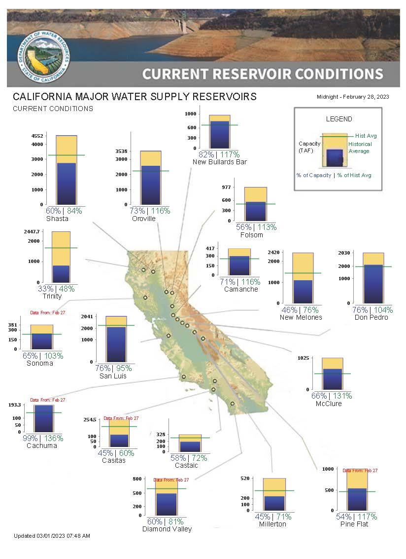
Here in California, reservoir storage across both federal and State facilities has been robust; total CVP reservoir storage was about 6.1 million acre-feet (MAF) as of yesterday (or 51% of total CVP capacity). Add in Oroville Reservoir, the largest SWP facility at 2.56 MAF and the total under storage stands at 8.63 MAF (or 56% of capacity of these facilities). I like to use to total CVP and Oroville as the primary indicator of federal/State reservoir storage.
Figure 1 below shows the Northern Sierra Precipitation: 8-Station Index for February 28, 2023. It reveals that the current index stands as 42.3 inches of precipitation, representing 118% of average for this date. Compare this to a month ago when the index was 139% of average. This is reflective of a relatively dry late January, early February.

Figure 1
Northern Sierra Precipitation:8-Station Index, February 28, 2023
Source: California Department of Water Resources
Despite a seemingly wet year, some may even say “overly wet”, the current WY is still only slightly above average as of this date. In fact, there is a very real chance that the WY ends up as average or marginally above-average barring a prodigious March and/or April.
By comparison, the San Joaquin Precipitation: 5-Station Index currently stands at 41.0 inches (or 154% of average for this date). Accumulated precipitation-to-date, already exceeds the annual average. In other words, even should no further precipitation fall in the San Joaquin Valley for the remainder of the winter/spring, the precipitation index will still declare this an above-average water year. The Tulare Basin Precipitation: 6-Station Index is 32.3 inches (equivalent to 172% of average for this date), also already above the annual average.
This has truly been a unique WY in the sense that the southern Sierra Nevada has experienced a much more vigorous hydroclimatic response than either the central or northern portions of the mountain range, a fact that is in stark contrast to most previous years.
Operationally, CVOC should be both pleased and wary. Reservoir refill is occurring at a manageable pace and operators have the assurance that a well-established snowpack across the entire Sierra Nevada can provide the much desired “top-off” as the precipitation season draws to a close and reservoir operators look to maximize storage before the high-demand irrigation season. The only regrettable fact is that without added storage capacity, many reservoirs have had no recourse but to “spill” or otherwise release significant quantities of accumulated stormwater, water that would be typically sought after, often times, desperately, in later months as surface and groundwater supplies become uncomfortably impaired. Folsom Reservoir, for example, has already “spilled” almost 190,000 acre-feet this WY; this does not include water released through various other means.
Nevertheless, the continually building California snowpack is an added water supply bonus this WY.
Statewide, the SWE stands at 42.0 inches. This represents about 162% of the April 1st average and 186% of the average for this date. As noted above, the southern Sierra SWE is calculated at 43.3 inches, or 224% of average. In the northern Sierra, the SWE is 37.1 inches (equivalent to 147% of the average for this date) and 44.4 inches in the central Sierra, or 191% of the average for this date. Clearly, snow contributions to the overall water supply outlook for 2023 can provide an important raw water augmentation once melted. But we must exercise caution. For as in previous years, water managers relying on SWE without carefully monitoring and accounting for hydroclimatic conditions run the very real risk of over estimating snowpack water availability, particularly under strong sublimating conditions.
We continue to closely monitoring daily CVOC actions to observe how integrated CVP/SWP operations are responding to hydroclimatological threats, both in the long- and short-terms. In particular, we want to identify and tally mandated flood “spills”, outlet releases, primary dam gate outflows, and powerplant discharges to compare against declared shortages and curtailment later in the season to help confirm ongoing State operational water “wastage” during flood episodes.
Current short-term forecasts project a period of 10-14 days of consecutive rain in north/central California starting this weekend. How these forecasts ultimately translate into broader Statewide precipitation accumulation (and managed releases) remains to be seen, but the water supply outlook for 2023 look promising.

