

The federal government has given the basin states until February 14 to reach a consensus solution that will serve as the basis for an agreement on the post-2026 guidelines. At the February 9 meeting of Metropolitan’s One Water and Adaptation Committee, Shanti Rosset, Metropolitan’s Colorado River policy manager, updated the committee members on the status of the basin states’ discussions. She also reported on the current hydrologic conditions, what they mean for those discussions, and how the DEIS frames Reclamation’s evaluation of its current decision.
The Bureau of Reclamation owns and operates Glen Canyon and Hoover Dams. It will ultimately decide how Lake Powell and Lake Mead are operated after 2026, consistent with the Law of the River. Under NEPA, Reclamation must complete an environmental review of post-2026 operations and issue a record of decision by October 1, 2026. This timeline is fixed.
The Draft Environmental Impact Statement (DEIS), released in January, is a legally required analysis of the environmental and other impacts from the proposed federal action. It does not select outcomes or represent a policy choice. However, it matters because the Bureau of Reclamation’s final decision must be justified and legally supported by the alternatives and analyses presented in that document. The federal deadline for the seven states to reach consensus is Saturday, February 14, at 5pm EST.
CONDITIONS ON THE COLORADO RIVER
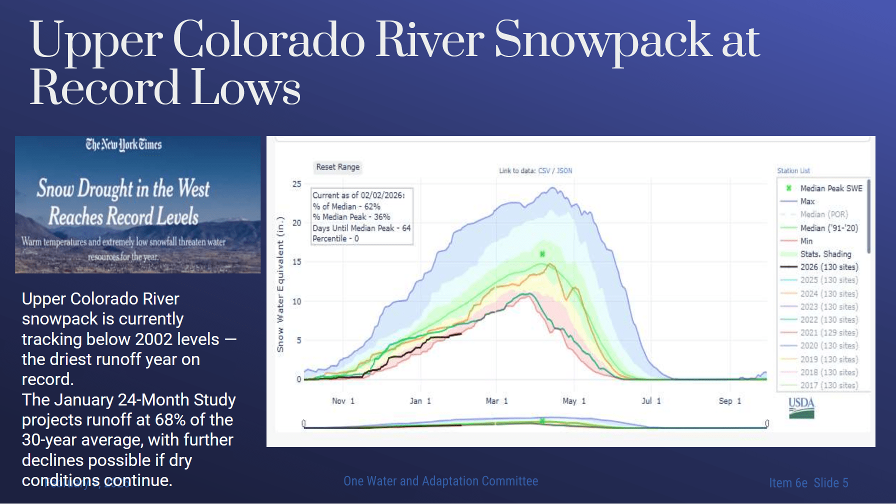
Ms. Rosset said this is tracking to be the driest year on record. Preliminary information shows that Reclamation’s February 24-month study—which forecasts river conditions over the next two years—will likely show about 1.5 million acre-feet less in forecasted inflow into Powell Reservoir than the January 24-month study.
As of this morning, the Upper Colorado River Basin snowpack is at 58% of the median. These conditions mean there will be lower initial levels at Lake Powell at the start of the post-2026 guidelines. Powell could reach record-low elevations sometime later this year.
“This makes post 2026 operations meaningfully harder,” said Ms. Rosset. “Starting closer to Lake Powell protection thresholds means less operational flexibility from the outset. There is a higher likelihood of lower Powell releases, earlier Lake Mead impacts, and fewer options to manage risk through timing or sequencing of actions.”
KEY ISSUES IN NEGOTIATIONS
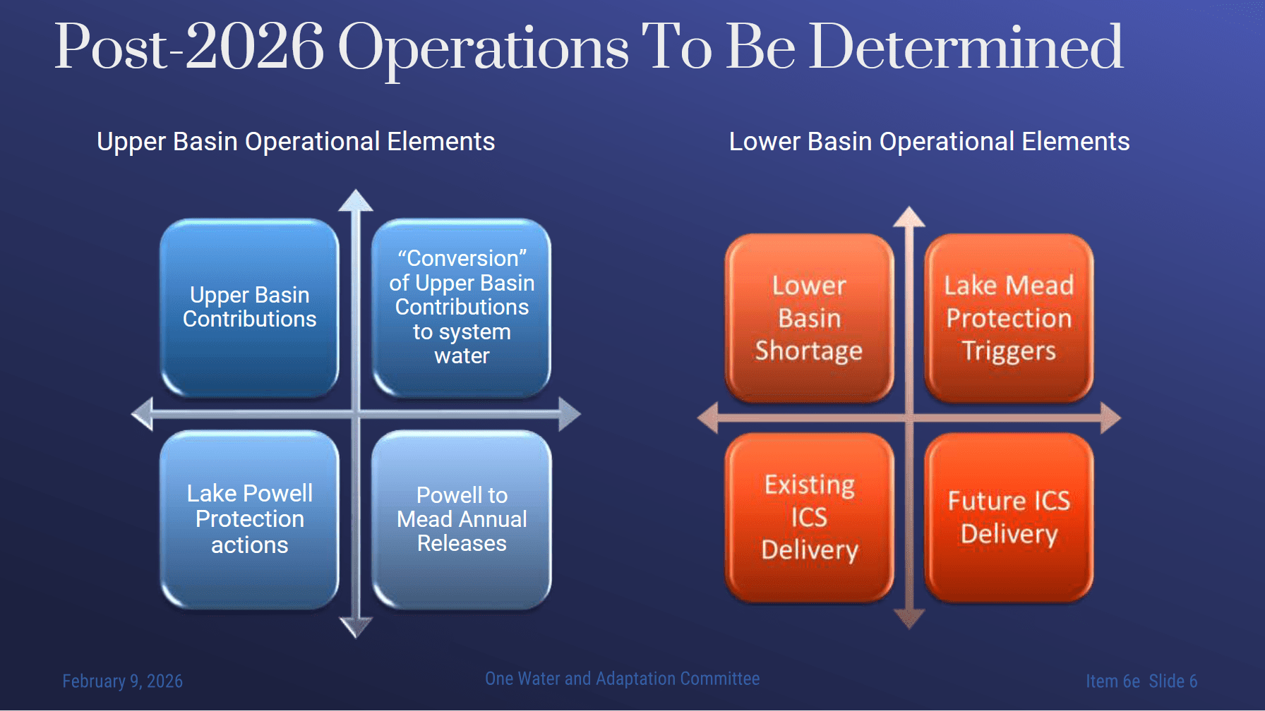 The negotiations remain fixed on key operational questions, which fall into two broad categories: operations in and above Lake Powell and operations in Lake Mead. For operations in the Upper Basin, the most consequential issue is Lake Powell releases, specifically, how annual releases from Powell to Mead are determined under increasingly dry conditions. Closely related is the question of upper basin conservation or contributions: how much water the Upper Basin would conserve over the term of the agreement, and whether such conservation would be mandatory.
Another central issue is the operation of the Colorado River storage projects in the Upper Basin, upstream of Lake Powell. Whether and how those releases are made to support Lower Basin releases or only to protect Glen Canyon Dam infrastructure remains a significant unresolved issue.
On the Lake Mead side, Arizona, California, and Nevada have tentatively agreed in concept on managing reductions of up to 1.5 million acre-feet for the Lower Basin and Mexico. However, it is still unresolved what would happen if more than 1.5 million acre-feet per year needs to be cut. It is also not clear how those additional reductions would be allocated, especially if Upper Basin actions are limited or voluntary.
For Metropolitan, Intentionally Created Surplus (ICS) supplies are particularly important. Metropolitan is looking to protect existing ICS supplies, ensure certainty that ICS can be accessed when needed, and preserve the ability to use ICS to meet Lower Basin reduction obligations. Metropolitan also wants to develop a new storage program, including the ability to support interstate exchanges, as part of a flexible and resilient post-2026 framework.
The term of the agreement is also a significant issue. Current basin state discussions have focused on a five-year agreement, reflecting uncertainty about hydrology and risk tolerance. Some states are talking about a phased approach, starting with a five-year phase-in, followed by an agreement on operations for years six through twenty. At this point, Ms. Rosset said it does not seem likely that the states will reach an agreement on a longer-term framework.
Finally, waivers have emerged as a central sticking point in the negotiations. Some upper basin states are seeking clear waivers from the lower basin as a condition of agreeing to upper basin conservation programs. At the same time, the lower basin states, particularly Arizona, have been clear that they will not grant a waiver absent a commitment for mandatory upper basin reductions. The tension between waivers and mandatory actions is a primary issue preventing convergence at this time.
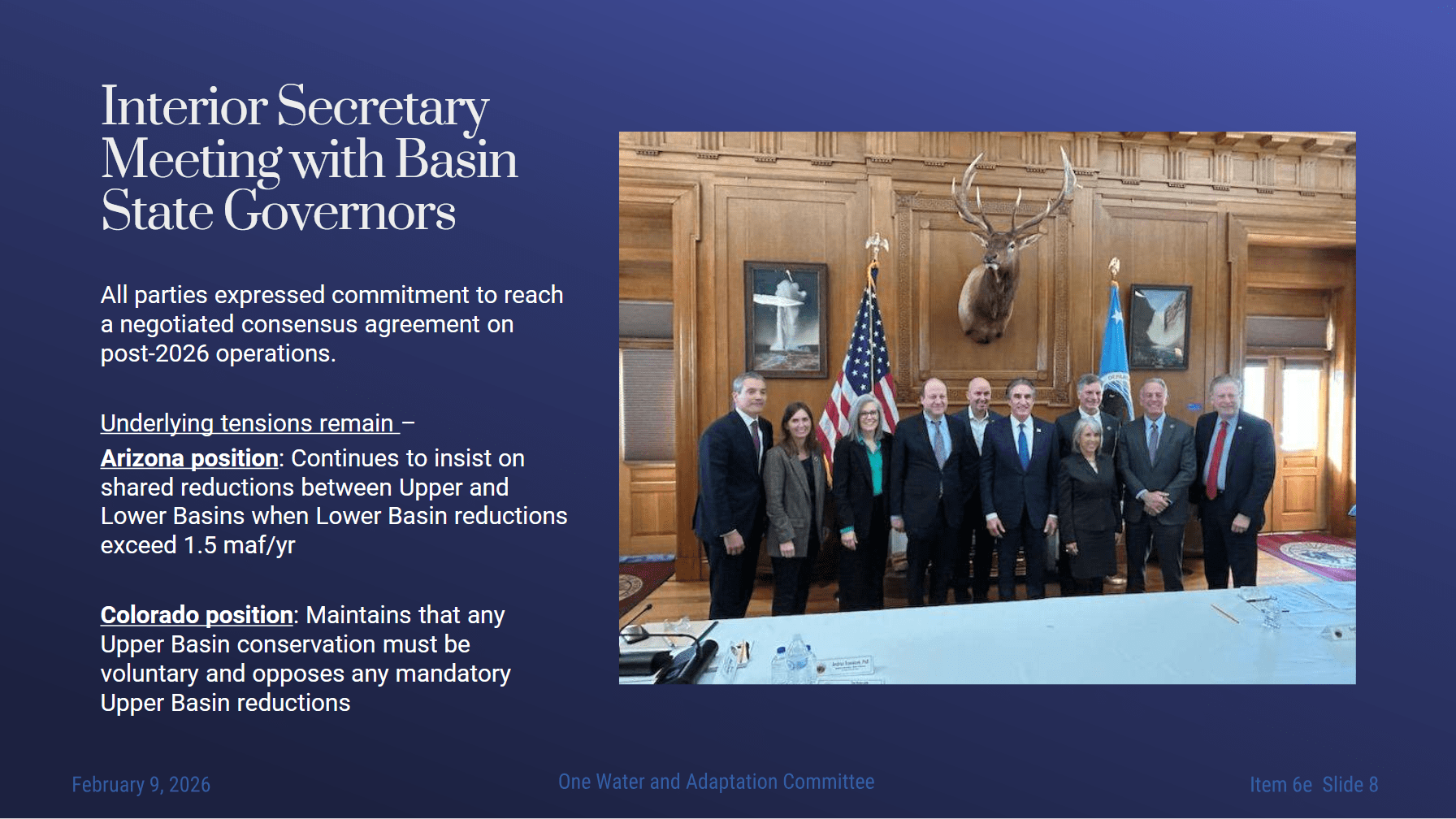 On January 27, the Interior Secretary met with the basin states’ governors in Washington DC. At this meeting, the governors publicly reaffirmed their commitment to pursuing a negotiated consensus on post-2026 operations. The message was deliberate and coordinated. At the same time, the meeting made clear that the lower basin states and the upper basin states remain stuck on whether the cuts would be taken in the lower basin only or shared between the upper and lower basin states once reductions exceed 1.5 million acre feet per year.
Arizona reiterated its position that reductions above 1.5 million acre feet should be shared. Colorado reiterated its view that any upper basin conservation should be voluntary and that the upper basin should not be subject to mandatory reductions.
So while the meeting demonstrated continued engagement at the governor level, it did not resolve the central disagreement, which continues to shape negotiations. It is also important context that Arizona is signaling internally that, absent a negotiated agreement that includes significant upper basin reductions, is unlikely to waive its compact rights and may pursue compact compliance claims.
Media coverage following the Secretary’s meetings with the governors reflected the heightened political attention, concern about the risk of impasse, and the growing interest in Washington in how the Colorado River operations will ultimately be resolved. This underscores the level of scrutiny Interior and Reclamation are operating under as they move toward a record of decision, and highlights the tensions between the states, up to the level of governors.
METROPOLITAN AND THE DEIS
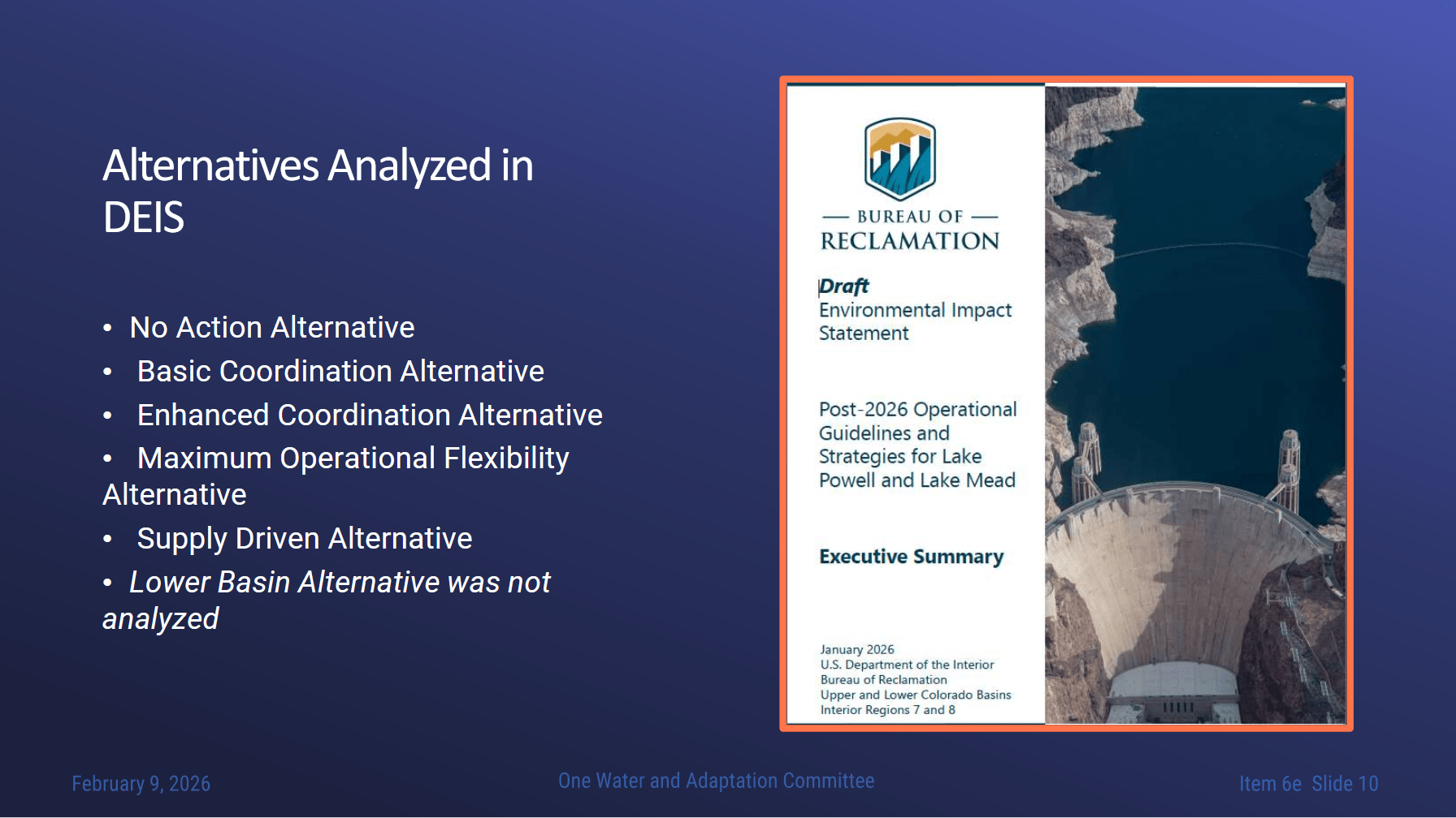 “The DEIS analyzes a wide range of potential post 2026 operations, including multiple coordination and supply-driven alternatives, but it does not meaningfully narrow the operational space in a policy sense,” said Ms. Rosset. “However, it does place sideboards around the possible post 2026 operations, because Reclamation’s final decision must be grounded on what is analyzed in the DEIS. The DEIS reflects a strong emphasis on protecting Glen Canyon Dam and Lake Powell infrastructure and several alternatives that protection is achieved primarily through reductions in supplies available to the Lower Basin and Mexico.”
For Metropolitan, the DEIS matters because it evaluates different operational frameworks for Powell-to-Mead releases, Lake Mead elevations, shortage determinations, ICS, and Hoover power generation. Metropolitan will submit independent DEIS comments by the March 2 deadline.
“Our comments will focus on modeling assumptions, legal authority, and the Law of the River interpretations used, water deliveries and shortages, Hoover power dam impacts, water quality, and protected species,” Ms. Rosset said. “The objective is to ensure that the final record of decision rests on realistic assumptions and sound legal and technical foundation.”
Outcomes are highly sensitive to the modeling assumptions that were used, particularly under critically dry conditions, she said, noting that the allocation method often matters as much as the total shortage volume, with direct implications for California and Metropolitan. Some modeled scenarios show significant impacts on Metropolitan, while other geographic and resource impacts are not fully analyzed in the DEIS.
MOVING FORWARD …
In closing, Ms. Rosset noted that they are operating in a constrained window with worsening hydrology, unresolved basin disagreements, and a DEIS that will define the bounds of Reclamation’s final decision.
“Taken together, the focus on short-term agreements, the central role of waivers, the prospect of litigation if consensus fails, and the emphasis on protecting Glen Canyon Dam underscore why the next several months are consequential for how much flexibility and risk are embedded in the post 2026 operations for Metropolitan,” she said. “Metropolitan remains actively engaged in the effort to reach a basin state agreement on the post 2026 guidelines, and we’re working towards the deadline for consensus on Saturday without certainty about where the negotiations will land. At this stage, there is still a long way to go before we can reach an agreement among the seven states, and it is not clear whether it’s possible. We will continue to keep the board informed as negotiations proceed.”
Bill Hasencamp, manager of Colorado River Resources, reiterated how dire the situation was becoming. “It is by far the worst snow pack in the history of snow pack measurements, which go back to the mid 80s, so at least in the last 50 years,” he said. “It’s the worst conditions by far – the warmest and lowest snow. And it means the Upper Basin will have to take some cuts this year because Mother Nature isn’t providing water. So farmers will have to stop irrigating halfway through summer, and even some cities may have to put on water restrictions. Places like Denver that have storage are probably okay this year, but they’ll be in bad shape if next year’s dry, and that’s with the upper basin not doing anything. That’s just status quo.”
He noted that the Lower Basin has exceeded its target of 3 million acre-feet of additional conservation over four years, yet with both reservoirs dropping fast and hydrology so poor, it’s ramping up stress across the basin.
“Tough choices have to be made, no matter what agreements we reach, or if things go to litigation – none of that’s going to add snow or water to the system,” he said. “We’re going to have to figure out, as a seven-state community, how to live with this new reality that we’re facing. Either we do it on our own, the feds tell us what to do, or a court tells us what to do – either way, it’s going to be difficult.”
Mr. Hasencamp acknowledged that everyone across the basin is working really hard. “But so far, we haven’t been able to get past some pretty hard lines that certain states have dug in the sand. California tends to be more moderate than the others, trying to bring us all to a deal, but so far, we’re not there today.”
WHAT ABOUT THIS YEAR?
Committee Vice Chair Nancy Sutley (LADWP) asked what the plan is for this year, given these incredibly dry conditions. Under the current operating guidelines, does the Department of the Interior have tools it can use, or is this something else that has to be done by consensus?
Ms. Rosset said there is a process, known as a 6E consultation, which references a provision in the 2024 SEIS. It is triggered when the 24-month study indicates a chance that Lake Powell will reach the elevation of 3525. The Interior Department initiates consultation with the basin states on the operations of Lake Powell to ensure it remains above the critical elevation of 3500. It’s a three-step process that includes changing reservoir releases, making additional releases from upstream reservoirs, and, if there is still risk of Lake Powell reaching elevation 3500 feet, reducing releases from Lake Powell.
“The releases from Lake Powell scheduled for this year are 7.48 million acre feet, and they could go down to as low as 6 million acre feet,” she said. “So we are definitely at risk, depending on how bad the runoff ends up being this spring.”

