

Subsidence from groundwater pumping has severely impacted land surfaces and infrastructure in parts of California. Rates of subsidence and its associated impacts have increased in some areas of California due to unsustainable groundwater pumping and practices and increasing climate aridification. The effects are costing Californians hundreds of millions of dollars annually in damage repairs, reducing water supply reliability, and jeopardizing public safety.
The August meeting of the California Water Commission featured an in-depth presentation on the Department of Water Resources’ (DWR) draft Best Management Practices for addressing land subsidence in California. These practices are designed to help local groundwater sustainability agencies better understand the causes of subsidence, how to monitor it effectively, and strategies for managing its impacts. The presentation was led by Paul Gosselin, DWR’s Deputy Director for Sustainable Water Management, and Shane Edmunds, leader of the Groundwater Sustainability Plan Review Section.
Subsidence is one of the six sustainability indicators required to be managed under SGMA. The Subsidence BMP does not supersede or replace any existing local, state, or federal regulations. Rather, it is meant to help Groundwater Sustainability Agencies and the public better understand land subsidence and how it can be managed.
As mandated by the Sustainable Groundwater Management Act (SGMA), DWR is required to present updates to the Water Commission and host three public workshops across the state to engage stakeholders.
Land subsidence in California
 The development of SGMA in 2014 was a response to the severe impacts of the drought, which led farmers to rely more heavily on groundwater to offset reduced surface water deliveries. This increased pumping led to thousands of dry wells and rapidly accelerating rates of subsidence.
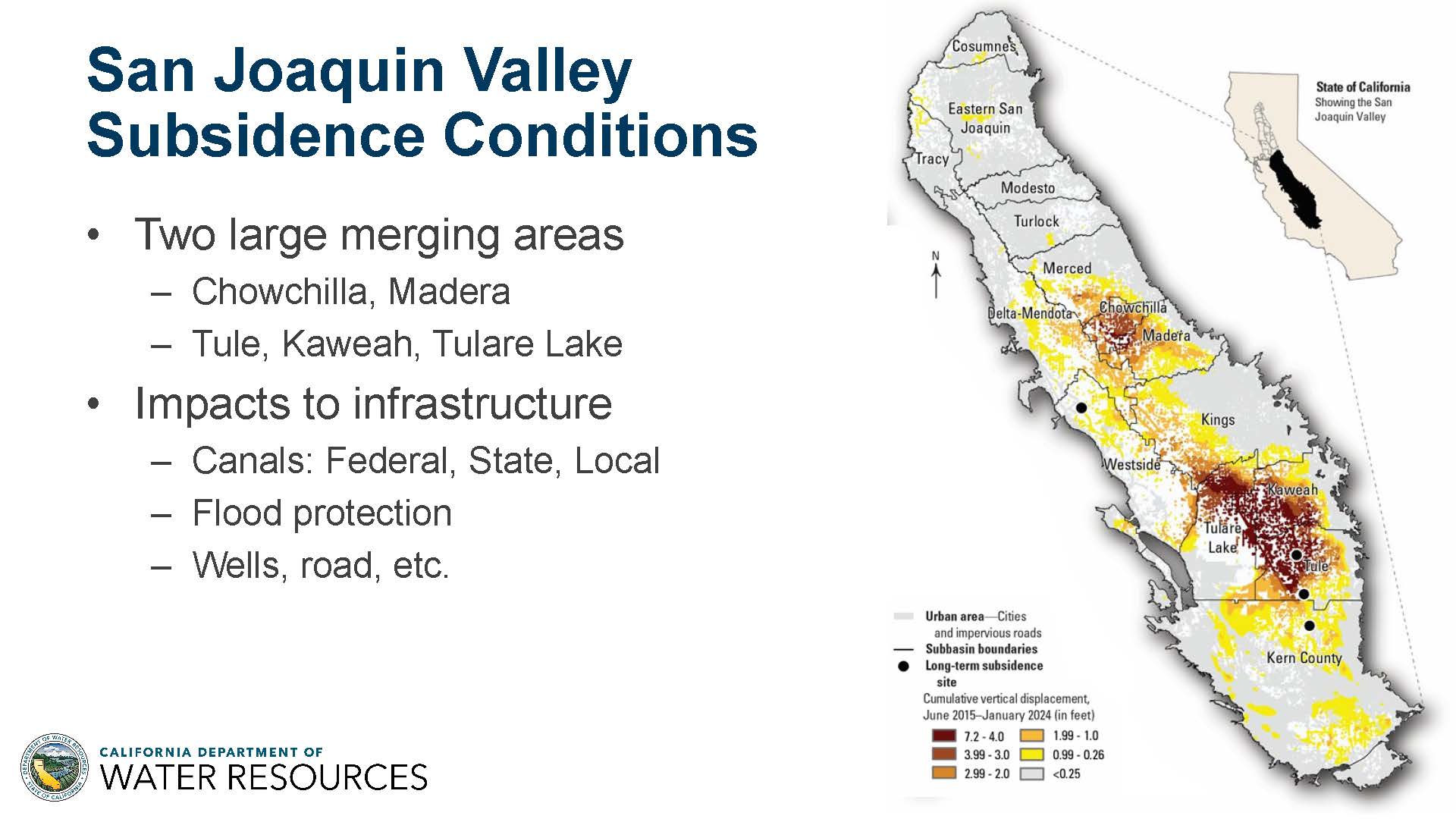
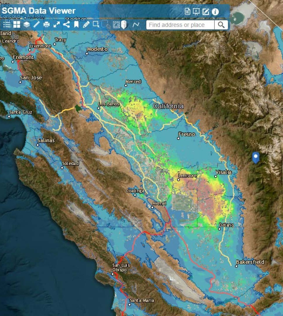
The graphic on the slide illustrates the extent of subsidence in the San Joaquin Valley since SGMA’s enactment in 2015. In some areas, subsidence has reached as much as seven feet over the past decade. Two primary areas of concern, or “bowls” of subsidence, have been identified: one near the Chowchilla and Madera region, and another spanning the Tulare Lake, Kaweah, and Tule sub-basins.
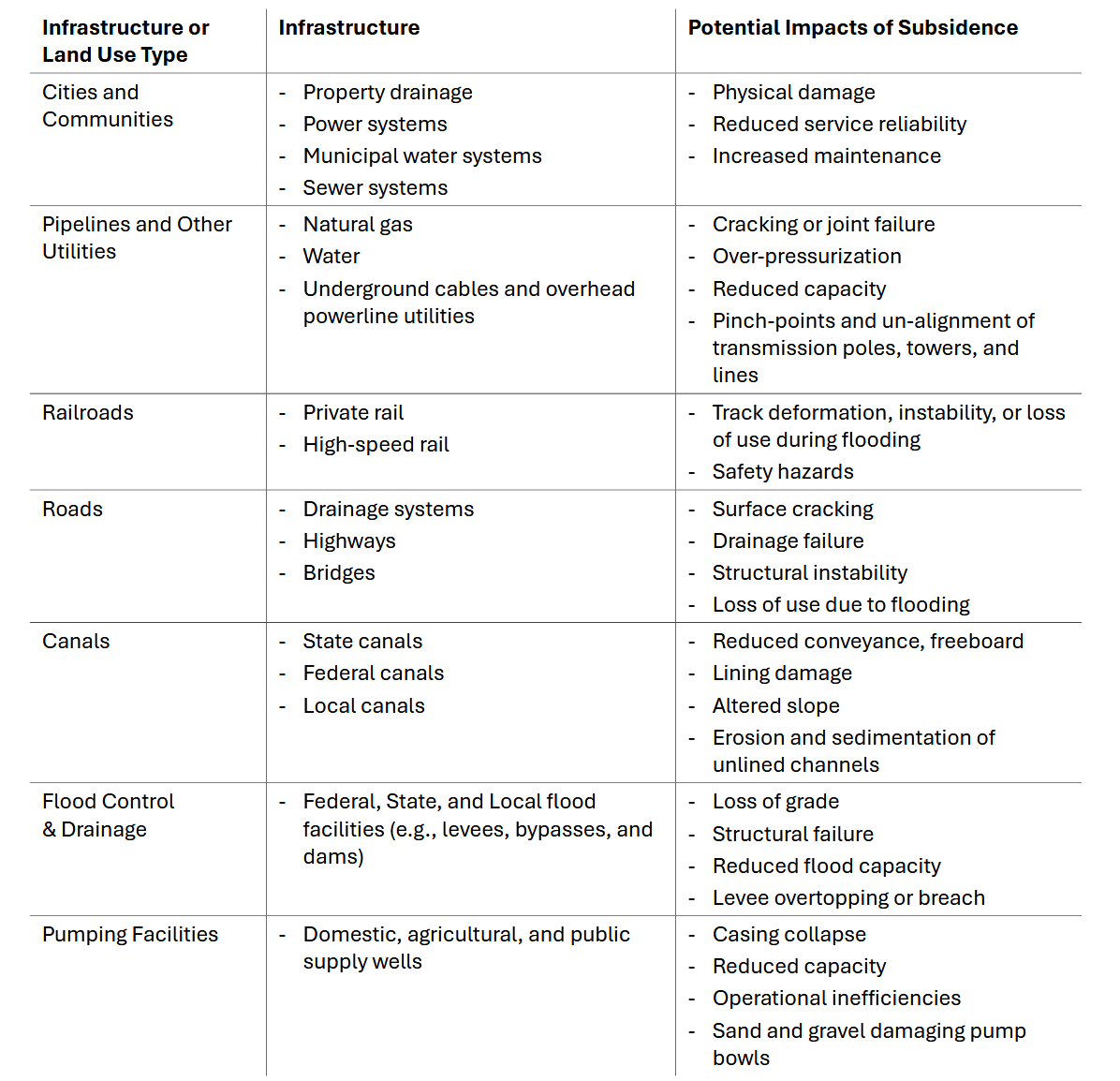
Subsidence poses significant challenges for critical infrastructure. Key systems tied to the State Water Project and Central Valley Project are being affected, along with flood protection levees, wells, roads, and buildings. These impacts highlight the importance of addressing subsidence as part of sustainable groundwater management efforts.
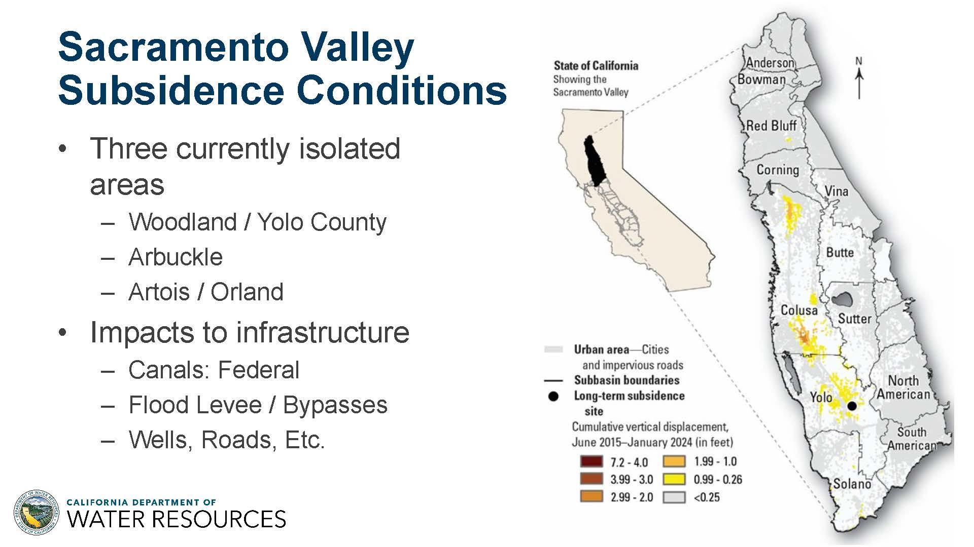 The Sacramento Valley is becoming an emerging area of concern for subsidence, a phenomenon not historically observed in this region. Since 2015, subsidence has been detected in three key areas: near Woodland, Yolo (close to the city of Arbuckle), and the Artois-Orland region.
While the extent of subsidence here is less severe than in the San Joaquin Valley—measuring around two to three feet—it still poses significant challenges. This subsidence is impacting critical flood infrastructure, as well as wells, roads, and other essential systems.
Structure of the BMP
The significance of subsidence and its role in groundwater sustainability plans prompted DWR to release the subsidence BMP. The BMP is designed to provide valuable information and guidance that can benefit all groundwater basins. “We wanted to make sure in the BMP, there’s something that all GSAs could look at and understand how it could impact them at the local level,” said Mr. Edmunds.
The BMP itself is approximately 45 pages. There are three main components of the BMP: Fundamentals of subsidence, including the causes of subsidence and how to minimize it; technical assistance for measuring and modeling subsidence; and subsidence management, which outlines the steps to take for effective subsidence management.
Fundamentals
The fundamentals section introduces key concepts essential to understanding subsidence:
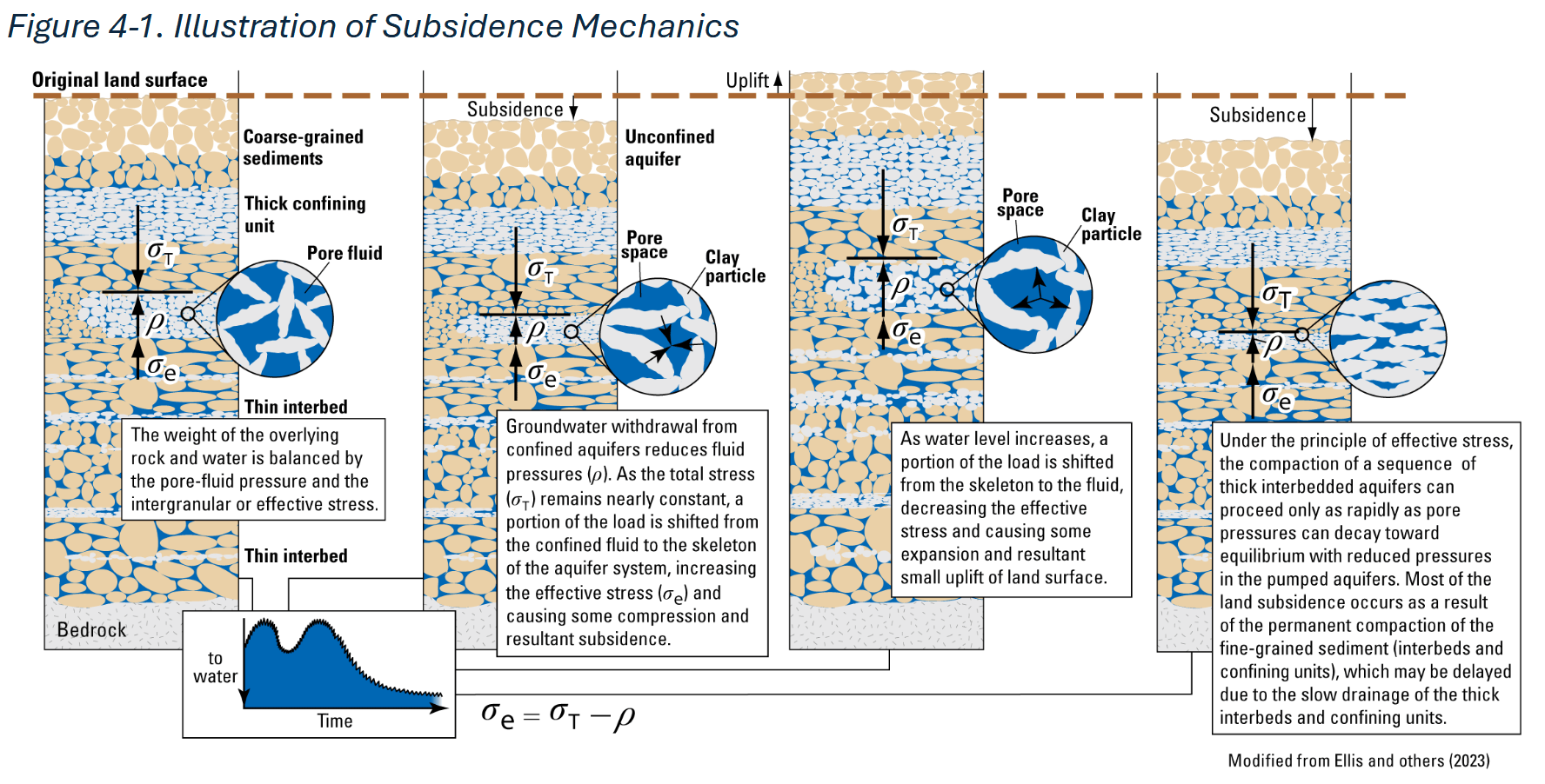
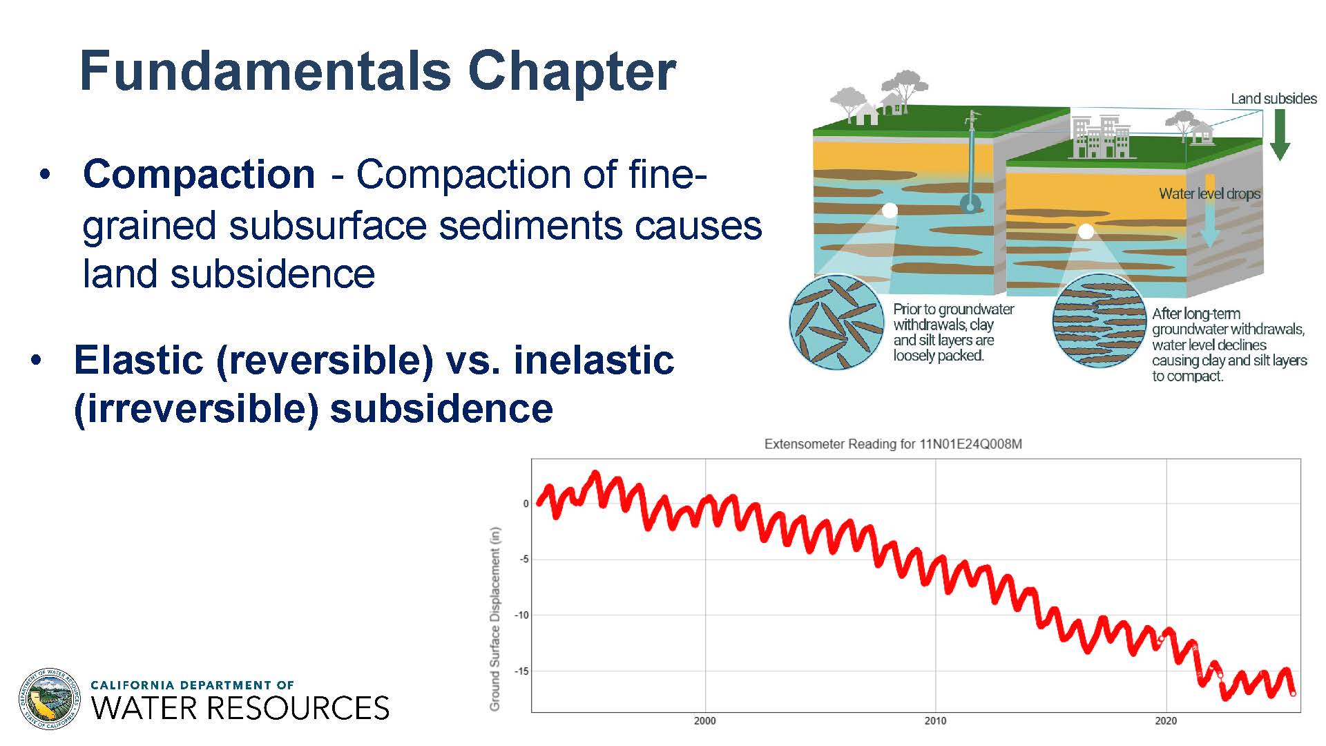 Compaction: The figure in the upper right provides a simplified illustration of compaction. When water is removed from the ground, fine-grained sediments collapse, leading to a lowering of the land surface elevation.
Elastic and Inelastic Subsidence: The graph on the bottom right offers a theoretical depiction of land surface changes over time. Elastic, or reversible, subsidence represents the annual fluctuations in land elevation as groundwater levels decline during the irrigation season and then recover during recharge. However, when groundwater extraction exceeds recharge, inelastic subsidence occurs, resulting in a permanent lowering of the land surface over time.
Critical Head: Critical head refers to the groundwater level below which inelastic subsidence begins. The figure below illustrates this concept, showing land surface elevation (red line) and groundwater levels (blue line with dots) from 1900 to the present. As groundwater levels declined, particularly around 1950, subsidence became evident as the red line dropped. The light blue line represents the critical head value. When groundwater levels fell below this threshold, inelastic subsidence occurred. However, around 1950, an inflection point is visible—groundwater levels began to rise above the critical head, halting inelastic subsidence.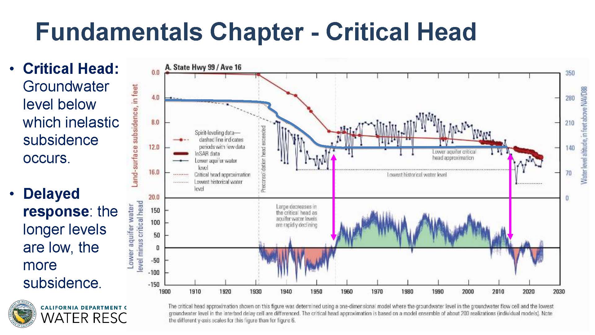
“So from about 1955 to about 2015, we were seeing residual subsidence, but that inelastic, active subsidence was no longer occurring because groundwater levels are above that critical head value,” said Mr. Edmunds. “Once again, in 2015 with the onset of the most recent drought, water levels once again dipped below critical head, and inelastic subsidence resumed. So this is a complicated figure, but it’s a core concept of the BMP is that if you manage water levels at or above critical head, inelastic subsidence will not be occurring.”
Key takeaways from this section are that to effectively minimize subsidence, groundwater levels must be raised as quickly and as far above the critical head value as possible. Adaptive management of groundwater levels is crucial to achieving this goal and preventing further inelastic subsidence.
Technical assistance
The technical assistance section focuses on monitoring and provides a comprehensive overview of methods to measure and manage subsidence. It explores various approaches to monitoring subsidence, including how to measure it effectively, and delves into the concept of critical head, offering three methods for calculating this threshold. Additionally, the chapter addresses infrastructure—how to identify it, the types of infrastructure affected by subsidence, and the importance of modeling subsidence to help GSA managers plan for the future.
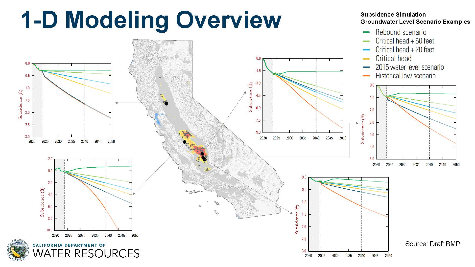 The BMP includes modeling results for five sites across California, marked on the map with large black dots. These models are forward-looking, simulating different water level management scenarios at each location. The graphs illustrate the critical head value and demonstrate how managing water levels above or below this threshold significantly impacts the extent of future subsidence at each site.
In addition to the five sites included in the BMP, an additional 45 locations will be featured in Bulletin 118, California’s Groundwater Update 2025, providing even more data for groundwater managers.
Key takeaways from this chapter are that subsidence can be measured using multiple methods, and there is a wealth of subsidence data available to local groundwater managers. While future subsidence involves some uncertainty, it can be effectively modeled to inform decision-making. Critical head, which declines over time as groundwater levels drop, can be estimated, though it also carries some uncertainty.
Subsidence Management
Two chapters in the BMP are dedicated to management strategies. Chapter 6 focuses on land subsidence within the framework of the Sustainable Groundwater Management Act (SGMA), while Chapter 7 provides a broader approach to land subsidence management, including an adaptive management strategy.
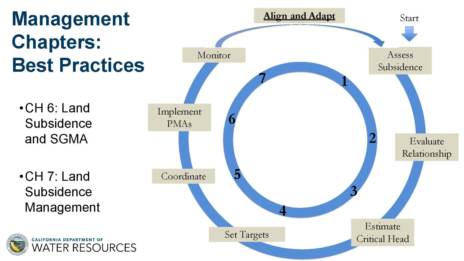 The first step for a GSA manager is to assess subsidence. This involves determining whether subsidence is currently occurring in the area or has occurred historically. Managers should analyze the relationship between water levels and subsidence to identify the critical head level, estimate it for their location, and set targets accordingly. Next, GSAs should implement projects and management actions (PMAs) designed to avoid or minimize subsidence. Monitoring the results is critical to ensure alignment with the Groundwater Sustainability Plan (GSP). Adaptive management allows GSAs to adjust their strategies based on monitoring data to better mitigate or prevent subsidence.
Coordination is another key step. GSAs should work collaboratively within their basin and across basin boundaries, as subsidence often extends beyond a single basin. Regional coordination is essential to address the issue effectively.
The BMP provides guidance on identifying infrastructure and offers recommendations for coordinating with the entities responsible for its operation and maintenance. It suggests that GSAs set subsidence targets in collaboration with infrastructure managers. Additionally, the BMP outlines methods for estimating future subsidence near infrastructure and emphasizes the importance of managing groundwater levels at or above the critical head level in areas adjacent to critical infrastructure.
The BMP concludes with four hypothetical management scenarios, designed to help GSAs consider and address subsidence in their basins. These scenarios are not basin-specific but provide examples of how to approach subsidence management:
- Scenario One: Groundwater levels are at or above historical lows, and the risk of subsidence is low. In this case, monitoring is recommended to ensure subsidence does not begin.
- Scenario Two: The basin has no history of subsidence, but GSAs are lowering water levels. Monitoring is essential, and GSAs should be prepared to act quickly if subsidence begins, with PMAs ready to mitigate its onset.
- Scenario Three: The basin has historically experienced subsidence but has since stabilized its water levels. GSAs should continue monitoring and managing to maintain stability.
- Scenario Four: The basin is experiencing active subsidence, and groundwater levels are being lowered. The BMP provides a range of recommendations for GSAs to address this situation.
“The key takeaway from the management chapters is that subsidence can be managed,” said Mr. Edmunds. “It is difficult, but overdraft really needs to be stopped in those areas. Because of uncertainty and the consequences, it’s really best to set conservative goals as a groundwater manager. And, as with many other aspects of SGMA, subsidence management is not a one-size-fits-all. Every basin is going to have its own individual local management strategies to avoid or minimize subsidence.”
Years of residual subsidence ahead
Subsidence stands apart from other sustainability indicators, like declining groundwater levels or seawater intrusion, because even with prompt action to address it, residual subsidence can continue for years, leading to ongoing and significant impacts.
Mr. Gosselin pointed out that the rate of subsidence has increased with every drought period since SGMA has gone into place, which is very alarming. “This is caused not only impacts to roads, levees, and wells, but also water supply conveyances, which, ironically, cuts off surface water supplies, which increases groundwater demand, which increases the rates of subsidence. So it’s a very circular aspect that’s causing negative impacts, and it’s taking billions of dollars of federal, state, and local dollars to just keep pace with addressing the continued problems of subsidence. That’s taking money away that could be put towards projects, actions, and other things.”
Next steps
The Department aims to finalize the subsidence BMP by the end of the year. Currently, DWR is not planning to introduce new regulations. Following a comprehensive review of scientific research, historical data, and existing SGMA regulations, it was concluded that an additional regulation is not necessary at this time. However, DWR remains open to implementing regulatory measures in the future if circumstances warrant it.
“This BMP does fit within the traditional aspects of how we’ve been addressing SGMA issues with GSAs by giving the broad breadth of options to agencies to address these issues through the range of monitoring aspects, the technical assistance we provide, the modeling aspects on critical head, and the other aspects for them to choose,” said Mr. Gosselin. “But we’re not just going to leave this BMP out there and see what their reaction is going to be. We are going to work shoulder to shoulder with the basins, particularly those experiencing subsidence right now, to provide technical and facilitation assistance. Because it’s really in all of our interests that this becomes successful. So we intend to have this BMP come out and to engage the basins in a very collaborative way.”
Mr. Gosselin emphasized that addressing subsidence is going to be ‘enormously’ hard. “It’s going to be more than raising it above the historic lows; in many cases, raising it many times higher than that, which is going to be enormously difficult, and which is probably one of the reasons why this has kind of lagged behind a lot of other indicators.”
“We are targeting the best management practice document to be completed by the end of the calendar year,” said Mr. Gosselin. “We’re going to gauge that on the comments we get and just make sure that we get a final piece that is the best product we can get, and then get that out and start working with the local agencies on implementation.”
Public meetings this week; Comments due by September 22
The DWR’s 60-day public comment period for the draft Land Subsidence Best Management Practices (BMP) document closes on September 22, 2025. To submit comments, interested parties can email sgmps@water.ca.gov or attend one of the upcoming in-person public meetings in Clovis, Delano, or Willows.

