

This periodically recurring atmospheric phenomenon in recent years has become just too unreliable to count on.
 By Robert Krier, Voice of San Diego
El Niño, once feared and nearly revered, has lost cachet.
It poses the threat of massive, damaging storms in California and also the potential to quickly wipe out severe drought. But this periodically recurring atmospheric phenomenon in recent years has become just too unreliable to count on.
This winter, a big emerging El Niño might bring Southern California deluges, perhaps destruction, as it did in the winters of 1982-83 and 1997-98. Many coastal roads, restaurants and businesses in San Diego County suffered damages in 1982-83. Statewide, damages topped $2 billion; in 1997-98, they topped $1 billion.
But the coming El Niño could also be like the 2015-16 version, which was billed by some as a can’t-miss “Godzilla” that would inundate the state. Instead of a monster, that one turned out to be a mouse.
California water managers were counting on that El Niño to produce, because the state was mired in a multi-year drought. But the 2015-16 El Niño mainly left the state high and drier.
After the very wet year that is just ending, the state doesn’t need another super wet winter for its water supply. But knowing what’s coming – if that’s possible – would be very beneficial to local and state officials who must plan, budget and prepare for the coming conditions.
Jan Null, a former National Weather Service forecaster who now runs his own private consulting agency called Golden Gate Weather Services, has kept extensive records about how these weather events have performed across California over the years.
Null has concluded that banking on a productive El Niño is not a wise meteorological investment.
“I don’t think the skill is there to make a very good judgment” about what El Niño will bring, Null said. “It very well could be a big event, but I will not reach into my wallet and put 20 bucks on it.”
The science just isn’t there yet, Null said. Going two for three in a baseball game is very good, but missing one out of three major seasonal forecasts, when the potential impacts are enormous, diminishes the value of the predictions.
Even the Climate Prediction Center, which issues El Niño forecasts, has toned down its wording this year as El Niño nears. The center learned its lesson after 2016. The current forecast calls for the emergence of a strong El Niño, but that “does not necessarily equate to strong El Niño impacts locally, with the odds of related climate anomalies often lower than the chances of El Niño itself.”
In other words, something big is definitely brewing, but what that will mean to us is hard to say. So far.
What Is El Niño?
El Niños happen, on average, every two to seven years. They are marked by unusually warm waters in the equatorial Pacific, a minimum of 0.5 of a degrees Celsius (0.9 of a degree Fahrenheit) above normal, over a multi-month period. Those warm waters pump energy and moisture into the atmosphere, and they can alter temperature and precipitation patterns around the globe.
Coupled with changes in the trade winds, they can help shift the jet stream and winter storm track south and bring above-normal rainfall to Southern California.
 Up until 2015-16, climatologists thought the warmer those waters in the Central Pacific, the bigger and more reliable the impacts. In 1982-83, the equatorial sea surface was 2.2 C above normal. In 1997-98, the waters reached 2.4 C above normal.
Both of those winters were extremely wet in Southern California, and coastal erosion and flooding problems were rampant, including in San Diego County.. The city of San Diego recorded 18.49 and 17.16 inches, respectively. Normal for a year in town is 9.79.
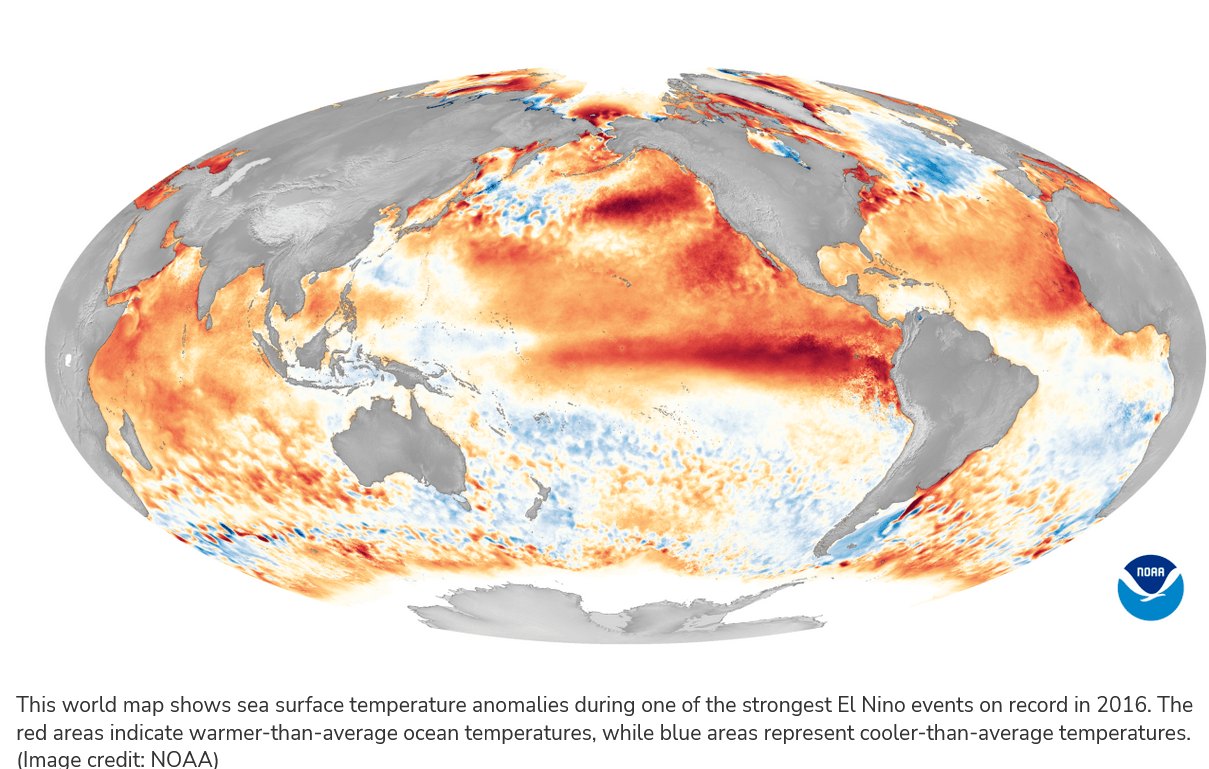
In 2015-16, the waters along the equator reached 2.6 C above normal, supposedly signaling an even stronger episode. Many chickens were counted before that winter hatched. But the impacts did not match the hype. San Diego got 8.18 inches, below normal, as was most of the state.
Since then, La Niña, which is marked by cooler-than-normal waters in the Central Pacific and usually signals winter dryness for most of California, has befuddled forecasters – twice. The year after the 2015-16 dud El Niño was a La Niña year, but it ended up being one of the wettest years in California history. Last year, another extremely wet year for the state, was another La Niña.
This year, in mid-September, the waters in that key region of the Pacific were running about 1.6 C above normal. That puts this El Niño in what the Climate Prediction Center considers the “strong” category. Some forecast models project those waters will continue to warm and get to around 2015-16 levels before winter, but the majority of the models show the warmth peaking not quite as high.
Is it time to worry, wonder, or relax?
Dan Cayan, a climate researcher at the Scripps Institution of Oceanography, said at the very least, the evolving El Niño bears watching.
“It’s an impressive event,” Cayan said. “It’s on pace to be a pretty strong El Niño.”
But Cayan, like many climatologists chastened after 2015-16, is careful with his wording about what he thinks is on tap.
“I don’t want to be overly exuberant,” Cayan said. “We’ve been humbled enough in the past to avoid that.”
In general terms, he said, the warm waters in the central Pacific have increased the odds of a good winter in Southern California.
“I would place my bets on wetter than normal from Point Conception southward,” Cayan said. “If the total ends up 15 percent or more greater than normal, I’ll feel vindicated.”
An encouraging sign is how the tropical atmosphere is starting to respond to the warming ocean, Cayan said. Cloud formation from the International Dateline east toward the Americas has been enhanced, while the western Pacific around Indonesia has seen reduced storm formation. Both are signs that this El Niño is behaving as expected – unlike in 2015-16.
“It’s early, but that’s a signal that ocean warming is impactful,” Cayan said. “I think the odds have shifted toward a lower Northern Pacific storm track that is active and at least from time to time will spawn cyclones that will make it into California and the West.”
That sounds like 1982-83 and 1997-98. Cayan doesn’t rule out 150 percent of normal precipitation in Southern California this coming winter. If massive storms coincide with high tides as they did in 1983, Cayan said, they could cause even more coastal damage because sea levels have since risen due to climate change.
But Cayan also doesn’t rule out a calmer winter with 90 percent of normal precipitation – which sounds like 2015-16.
Inherent Forecast Uncertainty
Michelle L’Heureux, who heads the Climate Prediction Center’s team that monitors the El Niño and La Niña cycle (called ENSO), said via email she hopes that after 2016, both climate scientists and the public have a “better appreciation for the uncertainty that is inherent” in seasonal forecasts.
“I consider it a good sign that no one has named this El Niño after a mythical beast this year,” she said.
 There has been a lot of El Niño-related published literature since 2015-16, L’Heureux said, but she’s not sure anyone has a surefire explanation for why we did not see wetter-than-average conditions in Southern California during that event.
“We still cannot rule out that just ‘random variability’ happened, and random variability can happen in any given year,” she said. “That chance is why we don’t offer guarantees and provide probabilities for certain impacts.”
Months before that recalcitrant El Niño in 2015-16, the prediction center listed a 40 to 60 percent chance of a wetter-than-normal winter in Southern California. L’Heureux said that’s far from a 100 percent promise.
“No one will ever get a guarantee with a seasonal climate outlook,” she said. But she said the impacts the CPC expected did develop elsewhere in the U.S. in 2016.
L’Heureux has studied previous El Niño events, including 2015-16. Her 2021 paper noted that even the most extreme El Niños offer limited predictability of California precipitation on seasonal time scales. She and other climate scientists did find a correlation between upper-level winds in the Eastern Pacific and statewide precipitation, but that link does not help forecasters predict more than a month ahead.
While a strong El Niño does appear to prime the pump for winter storminess in Southern California, other things going on in the atmosphere can interfere or muck up the works. The influence of climate change on El Niño is not fully understood, and there’s an alphabet soup of other large-scale oscillations in the Arctic, Atlantic and the Pacific (including the AO, NAO, MJO, and PDO) that could override or reduce El Niño impacts.
“Even if (big if) you could perfectly predict that alphabet soup of climate phenomena,” L’Heureux said, “you would still have a certain percent that can never be predicted because of chaos (butterfly flaps its wings).”
The ENSO cycle remains the biggest driver of seasonal forecasts, L’Heureux said, along with climate change/trends. It’s possible that some parts of the globe could, once again, not experience typical El Niño impacts. But given the strength of the current El Niño, it’s unlikely it will be shoved to the background everywhere, she said.
The center’s latest forecast maps show just a small tilt in the odds toward wetter-than-normal conditions in Southern California from December through March. The center’s forecasts still leave a better than 50 percent chance the winter will be either normal or drier than normal.
Despite El Niño’s presence and promise, Californians may not know if the state will fulfill its deluge potential until well into winter.
Continued Cool
September has continued San Diego’s long streak of cooler-than-normal months. The average temperature for the month, as measured at the city’s official weather station at San Diego International Airport, was 71.1 degrees, or 0.8 of a degree cooler than normal, though Thursday. This will be city’s 11th straight month, going back to November of last year, that finished cooler than normal.
This article was first published at the Voice of San Diego.

