

In California water news today …
Here’s the science behind the endless storms drenching California this winter
“This winter has been one for the record books, with the snowpack built up to colossal heights across the state. In the southern Sierra Nevada, the amount of snow is literally off the charts. “The graph had to be extended in the vertical, or y-axis, direction,” said Benjamin Hatchett, an Earth systems scientist at the Western Regional Climate Center and the Desert Research Institute, during a drought webinar on Monday. This bounty isn’t because of any single storm this winter — it’s due to an endless barrage of storms over recent months that came as something of a surprise to scientists. … ” Read more from the San Francisco Chronicle (gift article).
SEE ALSO:
- What the science says about California’s record–setting snow, from Nature
- Bomb cyclone, atmospheric river, polar vortex: How our weather terminology has grown with recent wild storms, from the LA Times
Drought Monitor shows majority of California no longer in drought. Here’s how that is figured out
 “More than half of California is no longer considered to be in a drought. That is according to this week’s Drought Monitor update, which was released Thursday morning. The outlook is produced by the National Drought Mitigation Center in collaboration with the National Oceanic and Atmospheric Administration, and the United States Department of Agriculture. This week’s update shows that 45% of the state is considered “abnormally dry.” That is down from 51% one week ago. The Sacramento area, San Joaquin Valley, Foothills, and Central and South Sierra are no longer experiencing drought conditions, according to the Drought Monitor. This trend is a positive one for the state, but it is important to remember that the Drought Monitor is one of many lenses that can be used to examine the status of drought. … ” Read more from KCRA.
SEE ALSO: Drought still grips these California counties as 72% of state recovers. Here’s where, from the Sacramento Bee
California’s snowpack soars to record high after 17 atmospheric rivers
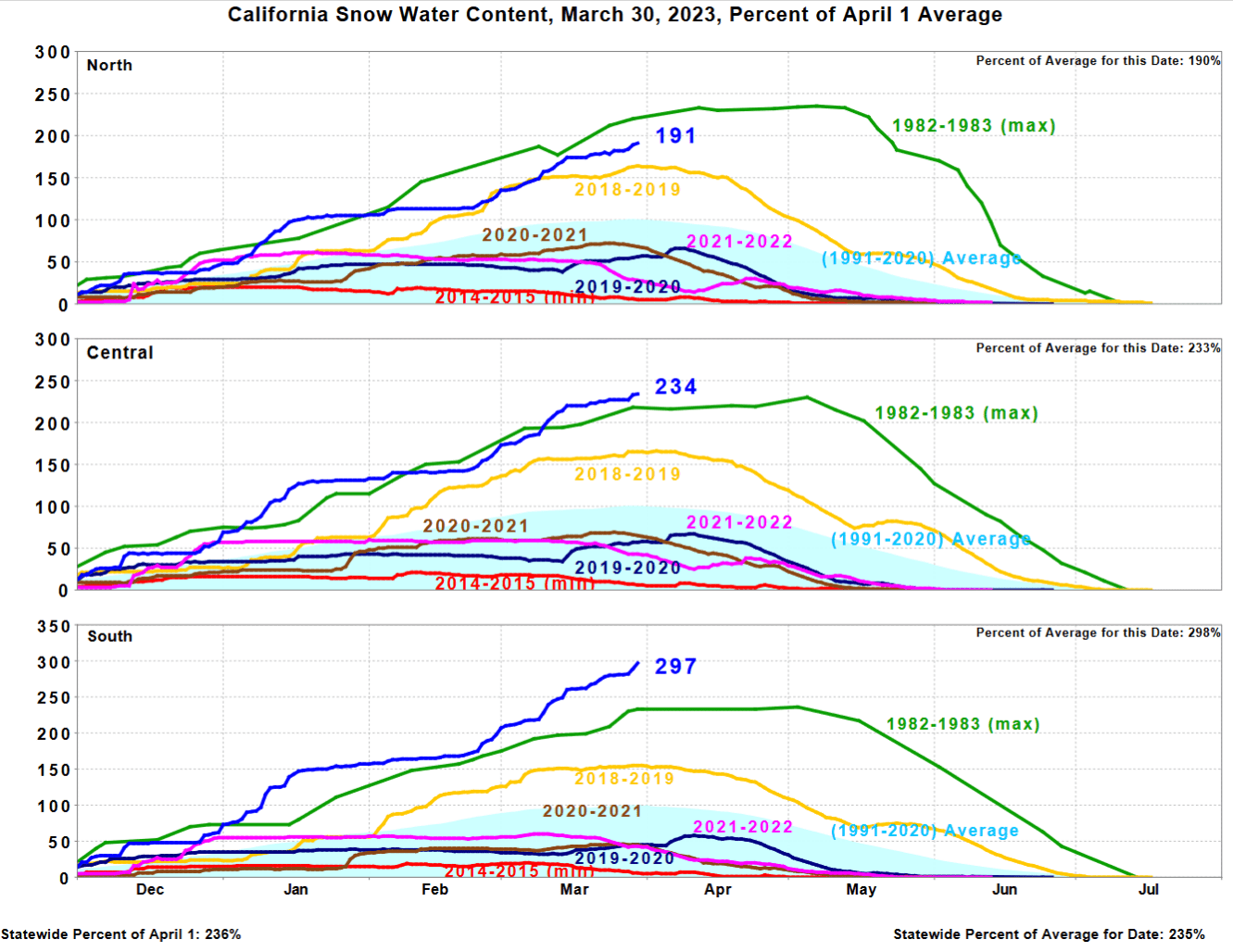 “The latest in the long onslaught of storms that began in December has pushed California’s snowpack to its highest level on record. This week’s storm dumped another one to two feet in the Sierra Nevada helping this season eclipse 1982-83, the previous record-holder. The water stored in the state’s snowpack is 235 percent of normal, according to the California Department of Water Resources, surpassing 234 percent in 1982-83. By far, the central and southern Sierra have seen the most unusual amounts of snow, with their snow water content 233 percent and 298 percent of normal, respectively. Comparatively less snow has fallen in the northern Sierra, whose snow water content is 190 percent of normal and still trails 1982-83. … ” Read more from the Washington Post (gift article).
SEE ALSO:
- Atmospheric Rivers Leave California Ag in Wait-and-See Mode, from Progressive Farmer
- Flood or feast: Drought-busting storms create winners and losers among farmers, from Cronkite News
This winter’s floods may be ‘only a taste’ of the megafloods to come, climate scientists warn
“The street in front of Antonio Hueso’s two-story, yellow-daisy-colored home in Pajaro turned into a 5-foot-deep muddy river in the early morning hours of March 12, submerging his baby-blue Ford F-150 truck and flooding his first floor. “In Pajaro, nothing is going to change because poor people live here,” said Hueso, 72, a retired farmworker, recounting more than three decades of requests from the community for local, state and federal officials to fix the aging levee on the Pajaro River, 4 miles upstream of his town. Several weeks after the levee failed — once again — forcing thousands of Pajaro residents to flee in the predawn darkness as water rushed toward their lower-income community in northern Monterey County, Hueso is beginning the arduous task of renovating his flood-damaged home. … ” Read more from KQED.
The coming flood: Meet the flood watchers
“Floods in California rarely attract the sort of attention that earthquakes, wildfires or even shark attacks do. Perhaps it has something to do with the severity of an unprecedented, yearslong drought that is far from over. This winter’s deluge — particularly in the northern and central regions — was a jolting reminder that rainfall remains a deadly, destructive force to be reckoned with, though it has been many decades since the Golden State experienced truly catastrophic flooding. Climate scientists, however, note that higher temperatures due to global warming mean the air can hold more moisture, resulting in more of the atmospheric rivers that have brought heavy rain to the state. It’s only a matter of time, they warn, before a sufficiently massive storm arrives to add to California’s legacy of devastating floods. … ” Read more from the University of California.
Madera County: Recent action on groundwater plan invites state to intervene
“Despite years of work and coordinated efforts, the Madera Subbasin appears headed for state intervention as only six of seven Groundwater Sustainability Agencies (GSA) approved a revised Groundwater Sustainable Plan (GSP). As the GSA with the greatest share of historical overdraft in the Madera Subbasin, the County GSA began developing an allocation in 2019 with the County GSA Advisory Committee to achieve nearly 40% reductions in the use of groundwater by irrigated agriculture. In 2019 and 2020, an allocation approach was developed and allocations for irrigated agriculture were adopted. Allocations were in place in 2021 as a “dry run,” and in 2022 as well with a penalty adopted for implementation in 2023. To date, preliminary findings indicate that the County GSA is well under its allocated water in the Madera Subbasin. Unfortunately, other GSAs have not developed allocations to manage their recognized share of overdraft, so it is not known whether sufficient demand management is taking place elsewhere in this subbasin. … ”
Experts weigh in on recent water at ‘Future of Ag’ summit
“Farmers, environmental experts, and scientists came together for Thursday’s ‘Future of Ag’ summit at Fresno State. They talked about everything from sustainable farming practices to new technology, and of course water. It came at an especially difficult time for farmers, with flooded fields and wet conditions, that have halted production and ruined crops. The excess water and moisture have been something on the minds of almost everyone in the Central Valley. The impacts from it have been felt across the board, especially in the ag world. … ” Read more from Your Central Valley.
Wet winter rains optimism for salmon releases
“A tanker trunk backed confidently down a boat ramp at Boyd’s Landing in Yolo County, looking as if it were about to dump a load of fuel into the briskly flowing Feather River. But as the driver flipped a metal lever on the back of the tank, the stream flowing into the river was instead a torrent of water flecked with the gyrating bodies of hundreds of thousands of chinook salmon smolts. This release of salmon, reared from eggs in the nearby Feather River Fish Hatchery, represents a future investment in the state’s salmon population — even as the current ocean population of chinook is so depleted from drought that fishery managers cancelled the 2023 salmon season fishery for only the second time in history. “The fish that are returning this coming fall were experiencing some of the worst drought years we’ve had,” said Jason Julienne, senior environmental scientist supervisor with the Calif. Department of Fish and Wildlife. … ” Read more from NBC Bay Area.
Salmon fishermen reflect on causes, future as closure looms
“For Jared Davis, the announcement was already a foregone conclusion. California’s salmon season will be closed in 2023, and he said there’s not any other option. “I think everybody was just here to send their support to the salmon advisory subcommittee that had a tough time trying to come up with these options, knowing the negative repercussions that it’s going to have on the fishing communities,” Davis said. The thread woven through all the challenges facing salmon and the fishing industry, is as Dominic Weaver, a recreational fisherman from the Mendocino Coast said: water. “The habitats that are threatened, it’s not because of the fishing, it’s not because of the predation out in the ocean,” Weaver said. “It’s coming down to not enough water because they’re diverting it and sending it other places.” … ” Read more from Northern California Public Media.
Suisun’s working landscapes support fish
 “On a sunny spring day in 2014, two UC Davis PhD candidates in waders pulled a 30-foot seine through Luco Pond (also known as the Potrero Duck Club) in Suisun Marsh. Luco Pond is within the Nurse-Denverton Slough Complex where duck clubs use tidal gates to control water exchange. After 45 minutes of counting diminutive fish, Brian Williamshen and Melissa Riley were excited to tally more than 6,900 sticklebacks, a thorny-backed native fish in the Sacramento-San Joaquin River Delta. “There was definitely a moment of excitement,” Williamshen says. “But when we were at our 50th fish, and the little spines kept poking us in the fingers, our emotions shifted to like, oh man, we still have hundreds more to go!” … ” Read more from Estuary News.
Bill proposes using satellites to study water consumption in West
“With drought taxing water supplies across the West, federal lawmakers introduced a bipartisan bill Thursday to better understand how much water we have, by figuring out just how much we lose. The legislation would create a new program under the Department of Interior to use satellite imagery to estimate how much water is lost to evapotranspiration from crops, which makes up one of the largest chunks of water consumption in arid environments like the American West. Evapotranspiration is the water from the ground and surfaces of plants that is lost to the atmosphere. Sen. Catherine Cortez Masto, D-Nev., and Rep. Susie Lee, D-Nev., reintroduced the Open Access Evapotranspiration Data Act on their respective congressional floors Thursday alongside Sen. John Hickenlooper, D-Colo., and Reps. Chris Stewart, R-Utah, Jared Huffman, D-Calif., and Burgess Owens, R-Utah. Similar legislation was introduced in 2021 and passed by the House before it died in the Senate. … ” Read more from the Las Vegas Review-Journal.
The Western Great Basin has an arsenic problem—blame its geology
“Thousands of private groundwater wells used by 49,000 people across the western Great Basin could be laced with dangerous levels of arsenic, new research suggests. Scientists at the Desert Research Institute in Reno, Nev., combined measurements of arsenic in water samples from across the western Great Basin with geological data to create a model that can predict where groundwater is likely to be contaminated. The results allowed the researchers to map the risk of arsenic exposure across the region. Tectonic and geothermal factors such as proximity to young faults and hydrothermal areas were among the strongest predictors of dangerous levels of arsenic. The findings were published in Environmental Science and Technology. … ” Read more from EOS.
California lawmakers join US Forest Service in battle to continue the use of aerial fire retardant
 “A lawsuit filed by Forest Service Employees For Environmental Ethics (FSEEE) is seeking to see the United States Forest Service end the use of aerial firefighting retardants claiming it is not in line with the Clean Water Act. The FSEEE is alleging that the USFS’s use of fire retardant on water is a pollutant and a National Pollutant Discharge System (NPDES) permit is needed under the Clean Water Act in order to drop pollutant’s into any navigable waters. The lawsuit was filed on Oct. 11, 2022 with the United States District Court for the District of Montana Missoula Division. … ” Read more from Fox 40.
SEE ALSO: ‘Just a placebo’: Lawsuit calls fire retardant ineffective and harmful, from the San Francisco Chronicle
Millions of trees have died in California forests. This map shows the hardest-hit areas
“California’s national forests, particularly those in the state’s northern interior, have lost millions of trees as the forests endure cycles of worsening drought. An aerial survey of forests in 2022 showed more than 36 million tree deaths statewide — nearly three times as many as the number recorded in 2021. The 36 million figure does not include trees that burned in wildfires, another major cause of tree deaths. Wildfire damage is tracked separately. Major causes of tree mortality in California include insects, diseases, wildlife and natural disasters, such as drought and flooding. This record number of tree deaths follows the hottest and driest three-year period for California, said Jeff Moore, survey program manager for region five, which includes California. … ” Read more from the San Francisco Chronicle.
In commentary today …
California may lose 10% of its water supply but a solution ‘is right under our feet.’
Sean Bigley, assistant environmental utilities director for the City of Roseville, and Dan York, general manager of the Sacramento Suburban Water District, write, “California’s rivers are once again surging with winter runoff, a beautiful sight after several consecutive dry years. Sacramento-area water providers have been working together to capture as much of excess water as possible for use during drier days. Yet, we could be doing so much more with additional support from state and federal decision-makers. Additional water storage is right in front of our eyes — or, more specifically, right under our feet. The City of Roseville, for example, captured surplus flows from Folsom Reservoir and stored this water in the groundwater aquifer using specialized Aquifer Storage and Recovery wells. Just a year ago, Roseville stored enough water to fill 160 Olympic-sized pools. Later, in 2022, we delivered that water to customers, leaving water in Folsom Reservoir to benefit our environment. … ” Read more from the Sacramento Bee.
Sustainable Groundwater Management is a David and Goliath story
Juliet Christian-Smith, Western States Regional Director with the Union of Concerned Scientists, writes, “Picture the small shepherd boy, David, pitted against the enormous warrior, Goliath. This is how it can feel when I step up to the microphone in the Capitol in Sacramento, California, to discuss some science-based analysis with policy makers. There is usually a line of lobbyists waiting to dispute any and all facts I, and other scientists like me, present. These, often well-heeled, Sacramento insiders represent oil companies, irrigation districts, and water agencies. They tend to have a similar set of talking points, written well in advance of the discussion, which they read off their cell phones before ducking out to do the same at another hearing in a different room. In such moments, it can be easy to feel overwhelmed, unheard, even helpless. Whenever I feel this way, I stop and remind myself that, sometimes, the little guy wins. Indeed, that is the story I would like to tell you: a true tale of the trials, tribulations, and eventual triumph of the underdog. … ” Read more from the Union of Concerned Scientists.
In regional water news and commentary today …
NORTH COAST
Yurok tribe, fishing groups sue over water delivery to farms
 “A northern California tribe is pressing the federal government to stop water deliveries for farming in southern Oregon and northern California unless a federal agency can show it’s met all legal requirements for endangered species, including salmon and killer whales. The Yurok Tribe, Pacific Coast Federation of Fishermen’s Associations and Institute for Fisheries Resources filed a motion for a preliminary injunction last week, the Capital Press reported. It’s part of a 2019 lawsuit against the federal Bureau of Reclamation and the National Marine Fisheries Service. The Bureau of Reclamation operates the Klamath Project, which provides water for about 200,000 acres (80,937 hectares) of farmland in southern Oregon and northern California. But the operations cannot threaten the survival of endangered species. … ” Read more from US News & World Report.
Lacks Creek restoration project funded by Bipartisan Infrastructure Law
“The Bureau of Land Management has announced $100,000 from President Biden’s Bipartisan Infrastructure Law will go towards completing restoration and improvement projects in the Lacks Creek Management Area in northwest California. The projects will support fire resilience and advance Tribal co-stewardship, with forestry crews from the Hoopa Valley Tribe completing projects on public lands within the Tribe’s ancestral homeland. Projects will include hazardous fuels reduction, prairie and oak woodland restoration and maintenance of previous fuels treatments completed by the Tribe. BLM California State Director Karen Mouritsen said the agency values the partnership with the Tribe and looks forward to upcoming accomplishments. … ” Read more from the Mad River Union.
MOUNTAIN COUNTIES
More cold temps, snow, wind expected Sunday/Monday at Lake Tahoe
“Maybe the biggest news for Lake Tahoe weather is that Friday is expected to be sunny with no snow showers, rain or strong winds, a first in several days, although temperatures remain well below seasonal averages. The sunny, clear day will be short-lived with another storm headed for the basin that will reboot more wind and snow on Sunday into Monday, according to a special statement from the National Weather Service in Reno. Light snow showers and breezy winds return on Saturday before travel may become impacted late Sunday into Monday which could affect the morning work commute. The highest snowfall rates are possible Sunday night, with a rain snow-mix Western Nevada cities. Along Interstate 80 and the Sierra crest, west of the basin, there is a 60% chance for up to 10 inches of snow, with a 15% chance of thunder embedded in the snow showers. For other areas of the basin, such as South Lake Tahoe, the service is calling for 2 to 6 inches. … ” Read more from the Tahoe Daily Tribune.
SACRAMENTO VALLEY
DWR continues flow reduction into Feather River
“The California Department of Water Resources could keep the Oroville Dam spillway open through spring as snowmelt and the potential for storms continues. On March 8, the spillway opened for its second time since it was built in 2018 to allow for some relief from Lake Oroville as storms piled on Northern California causing waves of heavy rain and low snow levels. Since the opening of the spillway, DWR has released just short of 800,000 acre-feet of water, said DWR State Water Operations Manager Molly White. “DWR has released a total of 787,417 acre-feet of water for storage management and flood control required by the U.S. Army Corps of Engineers between March 8 and March 29,” White said. … ” Read more from the Chico Enterprise-Record.
How much rain and snow fell across Sacramento and Tahoe in latest storm? Here’s an update
“After two days of on-and-off showers, Sacramento gets a sunny break with cool temperatures. This week’s storm brought moments of heavy precipitation to the Sacramento region. For the rest of the week you can expect tranquil weather with cooler than normal temperatures, said Scott Rowe, a National Weather Service meteorologist. “We should be right around 70 or 71 for this time of year in late March,” Rowe said. “We’re going to be well below that, but warmer than yesterday.” … ” Read more from the Sacramento Bee.
NAPA/SONOMA
Water rate hikes loom from Sonoma Water
“The Bay Area may be officially out of drought after recent rains filled up reservoirs, but they haven’t washed away fiscal issues water agencies have around the Bay, including Sonoma Water. Half full reservoirs captured the public’s attention in recent years, but water and the lack of it, isn’t the only challenge facing water managers. Even as the Bay Area exits drought, water use isn’t expected to sky rocket. It’s left utilities in a tough spot; people are saving so much water, it’s cutting into the money left for upkeep. “Our rates are fully volumetric and that means all else being equal,” Jake Spaulding said. “If we’re budgeting with lower deliveries, rates are going to increase and vice versa.” … ” Read more from Northern California Public Media.
BAY AREA
April storm for the Bay Area? Here’s what you need to know
“The Bay Area’s parade of March storms came to an end Wednesday afternoon as the weather pendulum swung from cold and wet to warm and dry. But things may swing back yet again early next week as weather models hint at another low-pressure system for the West Coast. What are the odds that it evolves into yet another storm? While weather models cycle through all the tracks the low-pressure system could take as it approaches California, a secondary tool kit in the weather arsenal — known as ensembles — help take a better snapshot of the system. These ensembles allow meteorologists to frame a picture of the low-pressure system’s wind and rain potential, highlighting its odds of becoming a storm by the time it arrives in the Bay Area around Tuesday. … For now, it looks like the consensus in weather models is that there may be some rain on Tuesday. … ” Read more from the San Francisco Chronicle.
When red tide smothered Lake Merritt, citizen scientists sounded the alarm
“It was the morning of August 28, 2022 and Lake Merritt’s red tide outbreak had made it a graveyard. The shore sediments were covered with silver dashes of goby fish and tiny dead sea life covered the edges of the Oakland estuary. … Within a day, the mild fishy smell had grown into a pungent foul odor. Navigating the lake, Damon Tighe, a self-described citizen scientist, was shocked at the unfamiliar and alarming sights: lifeless clams, their shells wide open as if to surrender their vitality; carcasses of countless aquatic animals embedded in the mud; in the water, schools of smelts and gobies frantically swimming towards the surface seeking oxygen as the bottom of the lake grew increasingly hypoxic. The magnitude of this massive die-off led Tighe to launch a campaign to crowd-source efforts to document the loss of biodiversity. His key tool was iNaturalist — an online platform that aggregates users’ pictures of flora and fauna and the observed location. … ” Read more from & the West.
More mud please for Novato Baylands
“Imagine a complex of tidal wetlands skirting San Pablo Bay unbroken from China Camp to Mare Island, providing vital wildlife habitat and protecting inland communities from storm surge and sea-level rise. With stretches of this shoreline formerly diked and drained (or in Hamilton Wetlands’ case, converted to a military airfield), reconnecting it may have once seemed unlikely. Yet today just two gaps remain, one of which is included in a restoration project that’s already underway: Bel Marin Keys. And it’s a doozy. The problem is one of scope—and more specifically of mud. The project site, currently partitioned into fields for agricultural use by a grid of berms and drainage ditches, is so large (1,900 acres), and the land so subsided that breaching its Bay-fronting concrete-and-riprap levee would flood much of the property, berms included, with multiple feet of saltwater. … ” Read more from Estuary News.
A steelhead renaissance in San Mateo Creek
“Rich Johnson steps through an inconspicuous gate between two backyards not far from the downtown San Mateo Caltrain station and points down a steep, overgrown streambank to a piece of PVC piping, barely visible beneath the tumbling water. “That’s our furthest downstream PIT array,” says Johnson, an aquatic biologist with the San Francisco Public Utilities Commission (SFPUC). The Passive Integrated Transponder array is one of four stations along San Mateo Creek that capture signals from tagged steelhead as they migrate up and down the creek. More than a month after a series of atmospheric rivers deluged the Bay Area in January, San Mateo Creek is still running high, fed by unusually large releases from Crystal Springs Reservoir. The high flows have prevented Johnson and his team from replacing damaged equipment, and delayed their annual fish spawning survey. Nevertheless, says Johnson, “I think there have probably been adults coming upstream” from the Bay. The return of steelhead to the creek is recent, and a testament to the power of freshwater flows to restore native fish populations. … ” Read more from Estuary News.
CENTRAL COAST
The power of water: Why levees don’t work, and the challenge of designing them differently
Journalist Kathryn McKenzie writes, “There has been a lot of discussion about why the Pájaro River levee failed, and who’s to blame for the breach that has decimated the Pájaro community. Likely there will be discussion about this for many moons to come. But consider that the ultimate fault may lie with the levee system itself, which has shown over and over to be doomed to failure. Levees across the United States have been repeatedly broken, breached and overtopped in the past century due to storm action, despite the best efforts of the U.S. Army Corps of Engineers and many other entities. Levee breaks have flooded many communities, often low-income neighborhoods occupied by people of color. Most notably this happened during Hurricane Katrina in New Orleans in 2005, when more than 50 levees and flood walls failed, inundating more than 100,000 homes and businesses and causing months, if not years, of misery for affected residents. … ” Read more from the Voices of Monterey Bay.
Weeks after flood, Pajaro residents still waiting to hear if their drinking water is safe
“Nearly three weeks after a chronically faulty levee broke and flooded the town of Pajaro in Monterey County, residents who recently returned to their flood-damaged homes are still awaiting test results to confirm their water is safe to drink, which will take another week, officials said. The Pajaro/Sunny Mesa Community Services District restored water service in Pajaro on Saturday morning, two days after evacuation orders were lifted. But the community’s nearly 2,000 residents are being urged not to drink it because it is “possibly contaminated” and could “result in illness,” according to notices on the district’s web page. … ” Read more from the San Francisco Chronicle.
SAN JOAQUIN VALLEY
Where do Valley rivers start – and end? Examining our ‘tremendously engineered’ system
“California has one of the most complex water systems in the world. And so, the factors giving rise to our region’s floods are more complicated than the simple cascading of rain and snowmelt downhill during a rainier-than-average wet season. We are well into one of the wettest winters on record in the San Joaquin Valley. Historic precipitation levels have buried the high Sierra Nevada under more than 50 total feet of snow. And parts of the Valley, stricken for years by severe drought, are underwater. The water in our region is delivered by rivers. Most of the major rivers in our region flow through reservoirs and dams, which, during normal years, help prevent flooding, but now are being forced to discharge huge volumes of water.Meanwhile, many of those rivers don’t actually flow all the way to the ocean – and all the water that drains here is overtaking the infrastructure that typically keeps it contained. … ” Read more from KVPR.
Tulare County: Recent rain is reprieve from atmospheric rivers
“The latest atmospheric river to hit the Valley may be more of an atmospheric creek. After two huge storms flooded parts of Tulare County earlier this month, the most recent storm on March 29 was a drop in the bucket on the Department of Water Resources’ runoff and flow charts. Tulare County’s two reservoirs – Lakes Kaweah and Success – have released a combined 80,000 acre feet of water since the second atmospheric river hit on March 15. The Army Corps of Engineers have been releasing massive amounts of water down rivers and canals, flooding areas along the foothills, in order to avoid overwhelming Schafer Dam near Porterville and Terminus Dam near Three Rivers. Warming weather and more rain are likely to combine to melt the record snowpack being stored at higher elevations and the Corps will continue releasing water to make room for those inevitable inflows. … ” Read more from the Foothills Sun-Gazette.
Allensworth residents no longer under evacuation order but are still struggling with White River flood water, other issues
“The evacuation order in Allensworth was downgraded to a warning on Monday as flooding and breaches don’t pose an immediate threat to the community for the time being, said Carrie Monteiro, public information officer for the Tulare County Emergency Operations Center. But the warning in place means there is still a potential threat and residents should be ready to leave, she added. The historic Black town of Allensworth sits on what was the southeastern edge of the old Tulare Lake bed, which was drained for farming more than 100 years ago. But the onslaught of storms starting in December has brought so much water, parts of the old lake are refilling. And new areas where land has collapsed from overpumping groundwater during the drought are also being flooded. … ” Read more from SJV Water.
Believe it or not, Tule River Reservation still has water issues
“It’s hard to believe but the tremendous rainfall and snowpack hasn’t really done anything to solve the Tule River Indian Reservation’s water crisis. That was the message presented by Tule River Tribal Council Chairman Neil Peyron in a video and press release posted on the Eagle Mountain Casino website. Peyron said the Tribe can’t store all the water that’s come from the recent storms in the video, adding the reservation needs an upgraded reservoir. ‘Recently we’ve been receiving a lot of rain, a lot of precipitation, a lot of snowpack on the reservation,” Peyron said. “You would thing it would help the tribe with its ongoing water crisis that it has during drier times of the year but unfortunately it does not. … ” Read more from the Porterville Recorder.
SOUTHERN CALIFORNIA
Skylinks project would treat wetlands-bound water, increase groundwater supply
“A new stormwater capture project at the Skylinks at Long Beach golf course near Long Beach Airport could help protect the Los Cerritos Wetlands from pollution and bolster the city’s groundwater supply once it’s completed in late 2024, a city consultant said. The project has been in the works for some time, but a design of the proposal, which would be installed on the eastern portion of the golf course between Fire Station 19 and Rosie the Riveter Park, was presented to the public Wednesday night. The project is being funded by a $10.5 million grant from Los Angeles County through the county’s Measure W parcel tax that was approved by voters in 2018 to create revenue for stormwater recycling projects. … ” Read more from the Long Beach Post.
SAN DIEGO
Diversity, inclusion key themes at Women in Water Symposium
“San Diego County Water Authority General Manager Sandra L. Kerl delivered an inspiring keynote address at the 2023 Women in Water Symposium at Cuyamaca College. The conference was not held at the college in 2021 or 2022 due to the coronavirus pandemic. And Kerl’s address focused on the sixth annual conference theme, “Building Resilience In Post-Pandemic Times.” At the March 29 symposium, Kerl shared insights and lessons from leading the Water Authority during the coronavirus pandemic. One lesson was learning how to do business in a different way while still meeting the Water Authority’s essential mission. “We need talent, knowledge, and fresh ideas from a wide range of people with a wide range of perspectives and life experiences and that is how we navigate a volatile, uncertain, complex, and ambiguous world,” said Kerl. … ” Read more from the Water News Network.
Along the Colorado River …
Senators to tour Colorado River as water negotiations reach critical juncture
“A bipartisan delegation of Western senators and federal officials will tour key points along the Colorado River next week to see the nation’s depleted reservoirs and the basin’s vast water infrastructure. The trip, which is being organized by Colorado Sen. Michael Bennet, a Democrat, comes amid tense state negotiations and looming federal action to address the fast-moving water crisis on the Colorado River. Water levels in the nation’s largest reservoirs Lakes Mead and Powell have dropped precipitously in recent years due to decades of overuse and hotter, drier weather driven by climate change. As the river basin declines, Western states are in a standoff over how to further cut water use – water that is used to not only grow the country’s produce and raise cattle, but for municipal household use and industry. … ” Read more from CNN.
It’s all white: Colorado’s statewide snowpack tops 140%, though reservoirs are still low
“Colorado is awash in white this spring, with statewide snowpack topping 140% of average this week, well above the reading a year ago, when it stood at just 97% of normal. “Conditions in the American West are way better than they were last year at this time,” state climatologist Russ Schumacher said Tuesday at a joint meeting Tuesday of the Water Availability Task Force and the Governor’s Flood Task Force. “In Colorado we went from drought covering most of the state to most of the state being out of drought.” Like other Western states, mountain snowpacks in Colorado are closely monitored because as they melt in the spring and summer, their runoff delivers much of the state’s water. … ” Read more from the Colorado Sun.
In national water news today …
Senate passes congressional review of WOTUS, Biden expected to veto
“The U.S. Senate passed the Congressional Review Act joint resolution of disapproval to overturn the Biden Administration’s Waters of the United States Rule. It passed by a 53-43 vote with four Democrats and one independent joining all the voting Republicans to pass the act. They include Democrats Joe Manchin of West Virginia, Jon Tester of Montana, Catherine Cortez Masto and Jacky Rosen of Nevada, and independent Kyrsten Sinema of Arizona. Senator Shelley Moore Capito, a Republican from West Virginia, introduced the resolution in February. In December 2022, the Biden Administration announced a new rule that repealed the Navigable Waters Protection Rule and changed the definition of WOTUS in a way that will significantly expand regulatory authority. … ” Read more from Ag Net West.
National water and climate update …
The Natural Resources Conservation Service produces this weekly report using data and products from the National Water and Climate Center and other agencies. The report focuses on seasonal snowpack, precipitation, temperature, and drought conditions in the U.S.
dmrpt-20230330
