
On the calendar today …
- MEETING: California Water Commission beginning at 9:30am. Agenda items include election of Commission officers, 2023 Commission workplan, Tribal representative comment policy, 2022 Annual Review of the State Water Project, Water Storage Investment Program: Road to final funding; Long-term drought: Overview of state drought actions. Click here for the agenda and remote access instructions.
- MEETING: State Water Resources Control Board beginning at 9:30am. Agenda items include Update on monthly water production and conservation data as reported by urban retail water suppliers, Racial Equity Action Plan, Consideration of a proposed Resolution to Amend the State Water Board’s Conflict of Interest Code, and discussion of yearly strategic work plan and board priorities. Click here for the complete agenda and remote access instructions.
- FREE WEBINAR: Calibrating Water Solutions to Climate Challenges: A Water Resilience Revolution from 10am to 11am. Climate change impacts are widely understood to be disruptive, primarily through expressions of the water cycle. However, uncertainties about how hydrological change will continue to evolve are also testing long-standing assumptions of how we best study, manage, value, pay for, and govern water resources. Long-standing measures of effective water management such as efficiency, optimization, sustainability, conservation, and reliability are at best weak indicators of climate adaptation. Water resilience is an emerging approach to develop systemic solutions to current and future climate threats. This talk will describe some of the outlines of water resilience that have been appearing globally, across a wide range of institutions. As new insights are embodied in decision making systems, we will explore how we can accelerate research and implementation to match the growing scope of the challenges we face. Click here to register.
- WORKSHOP: Fisheries Restoration Grant Program 2023 PSN Online Workshop from 10am to 11am. Agenda items include an overview of the 2023 PSN and guidelines, updates from 2022 PSN, and how to apply. Click here for the full agenda and remote access instructions.
- OCWA HYBRID EVENT: Metropolitan Water District update from 11:30am to 1:00pm. Attend in person or virtually. Click here to register.
- PUBLIC HEARING: Army Corps Delta Conveyance Project DEIS from 12pm to 2pm. The public draft Environmental Impact Statement (Draft EIS) for the Delta Conveyance project is available for public review and comment from December 16, 2022 through February 14, 2023. The notice and the draft EIS are available here. Three public meetings to receive comments from the public on the project and the draft document will be held on zoom. This is the last of the three meetings. Click here to access the meeting. Or by telephone: 1-833-548-0276 (Toll Free) Webinar ID: 850 6654 2191 Passcode: 026045
- WEBINAR: Whiplash Weather: Lessons from California’s Deadly 2023 Storms from 12:30pm – 1:30pm. Join the Stanford Woods Institute for the Environment for a panel discussion exploring the extent to which climate change is contributing to the intensity of California’s ongoing deadly storms, what modeling is telling us to expect in the future and how residents and decision-makers can plan and prepare for those projected impacts, particularly in overburdened communities. A panel of Stanford scientists joined by community leaders and responders will discuss the science behind this latest example of climate-fueled weather extremes, in addition to assessing implications for the state’s drought recovery and lessons for community preparedness. The discussion will also explore where resilience and adaptation or emergency planning efforts paid off at the local level and what tools and methods are available to provide solutions to both drought and flooding water storage challenges. Click here to register.
- WEBINAR: Sustainable Groundwater in California: The Challenges Ahead at 4pm. The Piedmont League of Women Voters is hosting Paul Gosselin, Deputy Director of Sustainable Groundwater Management in the California Department of Water Resources. During times of drought, groundwater accounts for up to 60% of the state’s water. Overdrafting is threatening supply, yet farmers need water for agriculture. The talk will be held live on Zoom and YouTube streaming and will include an audience question and answer session. Click here for more information and to register.
- WEBINAR: CW3E Forecast Tool Briefing from 4pm to 5pm. The Center for Western Weather and Water Extremes (CW3E) at Scripps Institution of Oceanography, UC San Diego will host a virtual technical briefing for water agencies on forecasting tools and watershed precipitation on Wednesday, Jan. 18 4-5 pm PT via Zoom. Please RSVP here to attend and receive the Zoom login link.
- GRA SF BAY: Annual Water board Update (virutal) from 6pm to 7:30pm. Topics include board news, sea level rise/groundwater level rise, Vapor intrusion mitigation guidance and policy, and case intake process. Click here to register.
- TOWN HALL: Rep. Harder’s Town Hall on Army Corps Delta Conveyance Project DEIS at 6pm in French Camp. The town hall will feature Harder as well as water experts from across San Joaquin County. After opening remarks, members of the community will have the opportunity to make their voices heard as it relates to the Delta Tunnel project. Harder’s office will then pass that feedback on directly to the Army Corps of Engineers. San Joaquin Health Plan Community Room, 7751 South Manthey Road, French Camp.
In California water news today …
Can we capture more water in the Delta?
 “A massive amount of water is moving through the Sacramento–San Joaquin Delta in the wake of recent storms, and calls have risen from all quarters to capture more of this bounty while it’s here. We spoke with PPIC Water Policy Center adjunct fellow Greg Gartrell to understand what’s preventing that—and to dispel the myth of “water wasted to the sea.” Q: Your recent policy brief said that California doesn’t do a good enough job of managing water supply in the Sacramento–San Joaquin Delta in wet years. Are we likely to see some of the effects that you highlighted this year? A: Yes. The brief focused on where we could have improved water management during California’s last three really wet years, which were 2011, 2017, and 2019. All three years had periods when the San Joaquin River was flooding, protections for salmon and steelhead were suspended, and the two water projects—Central Valley Project and State Water Project—could pump without restrictions. But the major reservoir south of the Delta—San Luis—was full, and there was simply no place to put the additional water. We could see that again this year, though a couple of things make that less likely. … ” Read more from the PPIC here: Can we capture more water in the Delta?
California faces catastrophic flood dangers — and a need to invest billions in protection
 “The storms that have been battering California offer a glimpse of the catastrophic floods that scientists warn will come in the future and that the state is unprepared to endure. Giant floods like those that inundated the Central Valley in 1861 and 1862 are part of California’s natural cycle, but the latest science shows that the coming megafloods, intensified by climate change, will be much bigger and more destructive than anything the state or the country has ever seen. A new state flood protection plan for the Central Valley presents a stark picture of the dangers. It says catastrophic flooding would threaten millions of Californians, putting many areas underwater and causing death and destruction on an unprecedented scale. The damage could total as much as $1 trillion. The plan, approved last month, calls for $25 billion to $30 billion in investments over the next 30 years in the Central Valley, and outlines recommendations that include strengthening levees and restoring natural floodplains along rivers. … ” Read more from the LA Times here: California faces catastrophic flood dangers — and a need to invest billions in protection | Read via Yahoo News
SEE ALSO: California’s storms are almost over. Its reckoning with flood insurance is about to begin, from Grist
Valadao, GOPers demand answers into Biden’s teardown of Valley water boost
“California Republicans are pressing President Joe Biden’s administration for answers regarding its proposed teardown of a 2019 environmental document that shapes the flow of water throughout the Golden State and drove an increase in water supplies to Valley farms. Rep. David Valadao (R–Hanford) led the way in December by making the request to Secretary of the Interior Deb Haaland. The backstory: In 2019, President Donal Trump’s administration issued new biological opinions governing the the management of California’s State Water Project and the Federally-run Central Valley Project. The previous biological opinions were issued in 2008 and 2009. ... ” Read more from the San Joaquin Valley Sun here: Valadao, GOPers demand answers into Biden’s teardown of Valley water boost
Here’s how California is trying to hold on to its rainwater
“California is trying to hold on to as much of its rain water as it can even as it deals with a terrible series of storms that has led to widespread flooding, 19 deaths and more than 20,000 homes without power. The reason is simple: the Golden State is also experiencing a three-year drought that had left Californians short of water. The state has experimented with a number of ways to hold on to the rain when it comes. Groundwater recharge: Researchers across the west are investigating and implementing groundwater recharge projects, or man-made interventions aimed at helping aquifers replenish themselves. “The general concept is you’ve got enough water on the surface. You’d like to put it in the ground,” explained Andrew Fisher, a professor of earth and planetary sciences at the University of California, Santa Cruz. … ” Read more from The Hill here: Here’s how California is trying to hold on to its rainwater
SEE ALSO:
- How torrential downpours make it harder for California to save up water, from Vox
- As California faces droughts and floods together, farmers look to new water technologies, from the CBC
- Michael Smolens column: Suddenly, water is everywhere. So are questions about saving more of it, from the San Diego Union-Tribune
Felicia Marcus: “Water is at the center of climate adaptation and where so many solutions lie”
 “The United States is facing various pressing water challenges, including drought, rising sea levels, ageing water infrastructure and polluted waterways. We speak to Felicia Marcus, William C. Landreth Fellow, Stanford University Water in the West Program, Founding Member, Water Policy Group, about some of these questions. Founding member of the Water Policy Group and the William C. Landreth Visiting Fellow at Stanford’s University’s Water in the West Program, Felicia Marcus has worked in most areas of the water sector, having turned her volunteer work into a successful and buzzing career. Serving in positions in government, the non-profit and private sector, she shares with SWM her vast experience and views on various pressing water issues, including the 50th anniversary of the U.S. Clean Water Act, climate mitigation, and the provision of clean water in disadvantaged communities, a topic particularly close to her heart. … ” Read more from Smart Water Magazine here: Felicia Marcus: “Water is at the center of climate adaptation and where so many solutions lie”
Holding Back a Flood: As California moves toward reintroducing beavers, landowners have turned to artificial beaver dams to protect their properties
“When the Sheep Fire swept through nearly 30,000 acres in and around Susanville, California in August, 2020, Hannah Tangeman’s Hulsman Ranch was badly burned. With all the vegetation burnt, there was no longer anything holding the soil together. A little more than a year later, in October, 2021, a powerful bomb cyclone hit Susanville, along with the rest of the Western United States and Canada. Fearing her house might be swept away during one flash storm, Tangeman fled her property and waited out the weather at a friend’s home. When the rains eased, Tangeman went back up to the ranch to see what the storm had done to her land. Parts of the main house flooded, and areas of the ranch were stripped clean of plant-life. But to her great surprise, the land near the stream was almost completely preserved. It seemed like a miracle, but the closer she looked, Tangeman realized it may have been more than good fortune. The parts of her land that escaped destruction were downstream from a couple Beaver Dam Analogs, man-made structures she and the company Symbiotic Restoration built the year prior that mimic a beaver dam and can slow and attenuate floodwaters. “I was stunned,’’ Tangeman says. “I was absolutely stunned.” … ” Read more from the Earth Island Journal here: Holding Back a Flood: As California moves toward reintroducing beavers, landowners have turned to artificial beaver dams to protect their properties
All the rain and snow in California may result in a big year for hydro — and that’s good news for the grid
“Torrential rain across California in recent weeks has caused plenty of misery, but it could also generate some good news on the energy front: If rain and snow totals hold up, all the precipitation will boost hydroelectric production — and that would help the Golden State’s electric grid, especially in the summertime when the system comes under strain. “Based on the reservoir levels and what we’re seeing this year, we expect to have more hydroelectricity generated this year than we have for the last several years,” said Lindsay Buckley, director of communications at the California Energy Commission. Lake Shasta near Redding is home to California’s largest reservoir, feeding the Shasta Powerplant, which produces hydroelectric power for the 15-state western power grid. As of midnight Monday, Lake Shasta was up to 83 percent of average, according to the Department of Water Resources. ... ” Read more from the San Diego Union-Tribune here: All the rain and snow in California may result in a big year for hydro — and that’s good news for the grid
Eating one fish from U.S. lakes or rivers likened to drinking month’s worth of contaminated water
“Eating one freshwater fish caught in a river or lake in the United States is the equivalent of drinking a month’s worth of water contaminated with toxic “forever chemicals,” new research said on Tuesday. The invisible chemicals, called PFAS, were first developed in the 1940s to resist water and heat and are now used in items such as non-stick pans, textiles, fire suppression foams and food packaging. But the indestructibility of PFAS, per- and polyfluoroalkyl substances, means the pollutants have built up over time in the air, soil, lakes, rivers, food, drinking water and even our bodies. … To find out PFAS contamination in locally caught fish, a team of researchers analyzed more than 500 samples from rivers and lakes across the United States between 2013 and 2015. … ” Continue reading at CBS News here: Eating one fish from U.S. lakes or rivers likened to drinking month’s worth of contaminated water
The field report: New research shows dangerous levels of ‘forever chemicals’ in freshwater fish
“In a study published yesterday, researchers at the Environmental Working Group (EWG) included alarming news for people who consume fish from lakes and rivers across the country. According to their analysis, eating just one serving of freshwater fish could be equivalent to a full month of drinking PFAS-contaminated water. While the data related to these “forever chemicals” isn’t new, Tasha Stoiber, a senior scientist at EWG and co-author of the new paper, told Civil Eats that the new analysis is significant because it shows that “even infrequent consumption of freshwater fish can have a significant impact on PFAS serum levels.” … ” Read more from Civil Eats here: The field report: New research shows dangerous levels of ‘forever chemicals’ in freshwater fish
California storms …
Final atmospheric river storm will slam the Bay Area today. Here are the biggest impacts
 “A strong high-pressure system in the eastern Pacific Ocean is creeping toward the West Coast, and it’s slated to shut California’s storm door. This is good news for residents across the state who are still reeling from the impacts that were brought on by nearly three weeks of storms — enhanced by a series of powerful atmospheric rivers. But this historic wet pattern isn’t done with Northern California just yet. A final round of moisture from the Pacific Ocean will stream into the Bay Area and Sierra Nevada this afternoon, ushering one last round of rain and snow bands before the wet pattern ends. ... ” Read more from the San Francisco Chronicle here: Final atmospheric river storm will slam the Bay Area today. Here are the biggest impacts
Rain and research opportunities abound with parade of atmospheric rivers
“The series of atmospheric rivers hitting the west coast have caused serious damage to infrastructure. The storms are also being studied extensively, including by Ryan Torn. “My work relates to understanding what is the predictability of landfall atmospheric rivers on the west coast of the United States,” Torn said. Torn is the chair of Atmospheric and Environmental Sciences at the State University of New York at Albany, and a researcher of atmospheric rivers at the Center for Western Weather and Water Extremes. “What are the factors in the processes that allow us to predict those features well in some circumstances,” Torn said. “And what are the circumstances and processes that create a lack of predictability?” … ” Read more from Northern California Public Media here: Rain and research opportunities abound with parade of atmospheric rivers
Storms bring water and havoc to farms
“Historic storms have hammered California for more than two weeks, causing widespread flooding, road closures, power outages and evacuations in numerous counties. As the state received roughly five times its average rainfall, the deluge offered water relief for drought-stricken farmlands. But the storms also inflicted a harsh toll on agriculture. Since Dec. 31, showers, mudslides and fierce winds ruined thousands of acres of crops, flooding vegetable fields with filthy water and wreaking havoc on orchards. In Sacramento County, a row of towering oak trees, planted as a property boundary, stood for over a hundred years before flood waters and “horrific” winds brought seven of them crashing into Ken and Charlotte Mitchell’s walnut orchard in Elk Grove. The oaks crushed more than a dozen nut trees, each of them a long-term investment worth thousands of dollars. ... ” Read more from Ag Alert here: Storms bring water and havoc to farms
Dry spell expected to slow California’s record snowpack pace
“California’s snowpack continues to grow at a record pace. However, an extended dry period will slow the growth for at least a couple of weeks. As of Monday, all three major basins were pacing above 200% of normal for Jan. 16, according to Department of Water Resources. In Northern California, the Northern Sierra/Trinity Basin was 209%. The Central Sierra was 246%, and the Southern Sierra was an astounding 288%. Experts say the most recent storm that moved out Monday will be the last significant moisture California receives in January as high pressure builds over the region. … ” Read more from Channel 12 here: Dry spell expected to slow California’s record snowpack pace
SEE ALSO: Sierra snowfall totals pile up after weekend storms, from the San Francisco Chronicle
500 mudslides, flooded communities, broken bridges: California faces long, costly storm recovery
“A pier in Santa Cruz split in half. Extensive flooding in Soquel Village, Capitola and Planada. Vital bridges badly battered or closed. More than 500 reported mudslides across California in the last few weeks, including some that damaged homes and cars in L.A. hillside communities. The atmospheric river storms that pummeled California for weeks inflicted “extensive” damage to as many as 40 of the state’s 58 counties, and total repairs could reach as much as $1 billion, according to authorities. The estimated cost is likely to change as teams of local, state and federal officials on Saturday began damage assessment that is expected to continue for several weeks, according to Brian Ferguson, a spokesperson for the Governor’s Office of Emergency Services. … ” Read more from the LA Times here: 500 mudslides, flooded communities, broken bridges: California faces long, costly storm recovery
Farmers frustrated with lack of water storage during heavy rains
“Water has been a hot topic after all the rainfall over the past few weeks, now many are asking how this helps with the state-wide drought. Jason Giannelli, a fourth-generation Kern County farmer, says farmers in the Central Valley pay for 100% of their surface water allocation, but only got 5% of it last year. He says if the water storage was better, we would be well prepared for dry conditions. “With the current storage we have, if they were at full capacity, if we were able to have 100% of storage on all the dams, we would have enough capacity for five years of drought,” Giannelli, said. ... ” Read more from Bakersfield Now here: Farmers frustrated with lack of water storage during heavy rains
SEE ALSO:
- Thirsty California reservoirs benefit from atmospheric river storms but drought is far from over, from Fox News
- Last of series of storms expected this week; snowpack at ‘epic’ levels, from the Lake County News
- Reflecting on three weeks of extraordinary weather, from the New York Times
- Stormy Winter: California Takes Steps to Manage Impact of Weather and Water, from the Sacramento Observer
In commentary today …
Rain finally came to California. We blew our chance to use it
Richard G. Luthy, a professor of civil and environmental engineering at Stanford University, writes, “After the driest three-year period on record in state history, Pacific storms, known as atmospheric rivers, just deluged California cities. But as much as we needed this water, a large fraction of it was lost by runoff to the ocean. This largely untapped resource that we can capture and use for water supply by reimagining how we deal with stormwater. This won’t be easy because we have more than 100 years of experience with treating urban runoff as flood control and property protection problems rather than a water supply opportunity. Reimagining how we use stormwater is important for California and relevant to other water-scarce places. … ” Read more from the San Francisco Chronicle here: Rain finally came to California. We blew our chance to use it
Water, water everywhere — but where is the science supporting its management in the Delta?
Dennis D. Murphy writes, “Much of the California public suffering from yet another round of flooding would be astonished to know that the water-export pumps in the south Sacramento-San Joaquin Delta serving agricultural and urban water users in the southern half of the state were operating at less than half of their capacity. State Water Project pumps that can operate at levels up to 8,500 cfs, had been reduced to just 2,000 cfs at the start of January, less than a quarter of their capacity. During the first week of this new year more than 200,000 acre-feet of water a day was flowing into the Delta and then out to San Francisco Bay. Last week that outflow had increased to over 300,000 acre-feet per day. For context, 300,000 acre-feet is about a third of the capacity of Folsom Lake. As California struggles to recover from three years of intensive drought and as water users in the San Joaquin Valley desperately yearn to restore groundwater supplies, this ongoing management of the state’s increasingly scarce water resources is mystifying. … ” Read more from the Center for California Water Resources Policy and Management here: Water, water everywhere — but where is the science supporting its management in the Delta?
California’s mega water wasters
Edward Ring, a senior fellow of the Center for American Greatness and contributing editor and senior fellow with the California Policy Center, writes, “It’s illegal to serve drinking water in a California restaurant unless the customer asks for it. Billboards sponsored by the state urge residents to put a bucket in their shower to capture water for their gardens. These symbolic pittances, along with escalating restrictions on water use by farmers and households that are anything but trivial, are the products of a deeply flawed mentality governing water policy in California. At the same time as government bureaucrats commit to ongoing water rationing, ferocious winter storms lash the state with hundreds of millions of acre-feet of precipitation. If this storm runoff were captured and stored, there would never be water scarcity again. But instead, it merely causes flooding and havoc, then runs into the vast Pacific Ocean. This is the story of California’s mega water wasters, one of the most delusional, self-righteous, destructive cults in the history of civilization. … ” Read more from American Greatness here: California’s mega water wasters
In regional water news and commentary today …
NORTH COAST
EPA proposes cleanup plan for Sulphur Bank Mercury Mine Superfund site

“The U.S. Environmental Protection Agency has released its preferred cleanup plan for the Sulphur Bank Mercury Mine Superfund site and is inviting the public to review and comment on the plan. The plan proposes cleaning up significant portions of the site in Clearlake Oaks, specifically the mine area, the sovereign territory of the Elem Indian Colony Tribe and contaminated soils in the residential area to the southwest of the site. “This proposed plan is the first step needed to reduce mercury levels in Clear Lake and address contaminated soil. These efforts will enhance public health and environmental safeguards, and advance environmental justice in the area,” said EPA Pacific Southwest Regional Administrator Martha Guzman. “EPA is committed to continuing to work with the Elem Indian Colony, the greater Clear Lake community and the Tribal nations as we develop a plan to clean up the Sulphur Bank site. We look forward to hearing the community’s feedback on our proposed plan.” ... ” Read more from the Lake County News here: EPA proposes cleanup plan for Sulphur Bank Mercury Mine Superfund site
MOUNTAIN COUNTIES
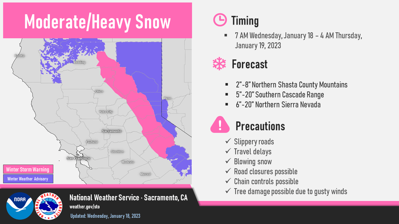
Fast-moving storm could drop a foot of snow at Lake Tahoe
“It’s frigid Wednesday morning in South Lake Tahoe with the thermometer showing 1 degree. The chilly temps are expected to last through the week and another storm drops into the region tonight, maybe the last storm for January. A fast-moving cold front moving into the basin Wednesday night could bring several inches of snow and travel disruptions over mountain passes and for the Thursday morning commute. The National Weather Service in Reno issued a winter weather advisory that goes into effect at 6 p.m. Wednesday and lasts until 4 a.m. Thursday. The service expects 3 to 8 inches of snow for Lake Tahoe and up to a foot above 7,000 feet and added that strong winds could hit 90 mph on Sierra ridges which will impact aviation and backcountry recreation. … ” Read more from the Tahoe Daily Tribune here: Fast-moving storm could drop a foot of snow at Lake Tahoe
Field Note: Monitoring Sierra Meadows for soil & water indicators of meadow health
Kam Bezdek writes, “In mid-October of this past year, CalTrout Sierra Headwaters Project Manager Marrina Nation and I ventured to Double Bunk Meadows and Horse Meadows, near the Trail of 100 Giants in the southern Sierra Nevada. The goal of the trip was to accomplish some field work before the winter season and to enhance my policy and advocacy work for CalTrout by learning more about the Sierra Meadows projects and the restoration practices involved. In preparation for some of the policy work I was beginning to delve into, I researched CalTrout’s work in the Sierra and read through the WRAMP protocols. SM-WRAMP stands for Sierra Meadows Wetland and Riparian Area Monitoring Plan. This Plan is a set of field protocols designed to quantify the success of mountain meadow restoration projects by assessing pre- and post- restoration conditions. SM-WRAMP was developed according to a statewide framework by the Sierra Meadows Partnership. CalTrout spearheaded the effort to bring these complex guidelines into a cohesive working document to standardize data collection and reporting. I was so excited when CalTrout Sierra Headwaters Director Sandra Jacobson suggested that I make a trip to the meadows to see CalTrout’s restoration work in person. … ” Read more from Cal Trout here: Field Note: Monitoring Sierra Meadows for soil & water indicators of meadow health
Placer County Water Agency files suit against PG&E for breach of contract
“Placer County Water Agency (PCWA) has filed suit against Pacific Gas & Electric Company (PG&E) in Sacramento County Superior Court for breach of contract. This action follows disclosure of PG&E’s intent to transfer substantially all its power generating assets, including its Drum-Spaulding Hydroelectric Project in Placer County, to a subsidiary recently formed by PG&E. Under a Water Supply Agreement with PG&E, PCWA is entitled to approximately 125,000 acre-feet of water supplied by this project, which is the principal source of water for Placer County residents and businesses. The Water Supply Agreement between PCWA and PG&E was amended in 2015 to require PG&E to give PCWA at least six months advance notice if it intends to sell some or all of the Drum-Spaulding Hydroelectric Project facilities. During this time, PCWA has the right to discuss its interests and options to secure this source of water for Placer County. PG&E failed to honor this six-month negotiation window. … ” Read more from YubaNet here: Placer County Water Agency files suit against PG&E for breach of contract
SACRAMENTO VALLEY
Shasta Dam’s water releases, explained
“In the wake of the 12th wettest start to a year on record, concerns over where that water is ending up have risen. Lake levels have risen as well, but have water releases from Shasta Dam hampered that storage? “Well right now we’ve had a spectacular two weeks; the lake has come up 50 feet since the first of the year, which is tremendous news for us. What we’re doing right now though is holding back every last drop of water we can because we started so low. So right now we’re doing minimum releases out of Shasta, out of Keswick; downstream of that, the creeks were running really high because of all the rain so that was what was impacting all the people down south of us,” explained Don Bader, the Area Manager of the Bureau of Reclamation. The swollen river and creek levels were not an impact of the dam’s outflows, but what explains the ever-changing release levels? … ” Read more from KRCR here: Shasta Dam’s water releases, explained
Tehama County hosting workshop on well registration program
“The Tehama County Flood Control and Water Conservation District are inviting the public to participate in an interactive public workshop to learn and share input about the Tehama County Well Registration Program. The meeting will take place from 6-8 p.m., Feb. 8, at the Red Bluff Community Center, 1500 South Jackson St. This will be an in-person workshop. During the workshop, an overview of the Tehama County GSA Well Registration Program will be followed by a question and answer period. Assistance with completing well registration forms will be provided too. … ” Read more from the Red Bluff Daily News here: Tehama County hosting workshop on well registration program
State allocates up to $4M for ‘critical repairs’ on Sutter Bypass levee
“Officials announced last week the signing of a partnership between the Sutter Butte Flood Control Agency (SBFCA) and the California Department of Water Resources (DWR) for the design, environmental and permitting work that will be needed for critical repairs to four areas of the Sutter Bypass east levee. Even though more than $300 million already has been invested by local, state and federal agencies in repairs to the west Feather River levee since 2010, properties south of Yuba City are still vulnerable to potential flooding from other sources, such as the Sutter Bypass, officials said. In order to address that issue, the partnership between SBFCA and DWR was made official. … ” Read more from the Appeal Democrat here: State allocates up to $4M for ‘critical repairs’ on Sutter Bypass levee
Cordova Creek Naturalization Project nears final phase
“The Water Forum is making strides to complete the naturalization of Cordova Creek, one of the few tributaries of the Lower American River with year-round water flow. These flows, derived primarily from clean water outflows from Aerojet’s upstream groundwater treatment plant, make the creek especially important to the Parkway’s riparian plants, wildlife, and fish including juvenile salmon and steelhead. But, for decades, the creek has been accessible to fish only when American River flows are very high. That’s because the transition from creek to river is very steep, the result of a drainage ditch project in the last century that paved the creek in an attempt to reduce erosion. … ” Read more from the Water Forum here: Cordova Creek Naturalization Project nears final phase
Flood pumps pushing maximum capacity as officials look for funds to replace them
“Homeowners could see an increase on their bills as Reclamation District 1000 launches Proposition 218 to make improvements. The district is currently pumping out the canals to make sure there isn’t any flooding. “We have been pumping pretty consistently since the first of the year since that big storm on New Year’s Eve. At one point, we pumped for about seven consecutive days,” said general manager Kevin King. The district is missing almost 35% of its pumping capacity. “We are 30 years behind on deferred maintenance and capitol replacement,” said King. That’s why residents are now getting notices about the 30-year capital improvement plan. … ” Read more from Channel 10 here: Flood pumps pushing maximum capacity as officials look for funds to replace them
BAY AREA
Rainfall totals for parts of the Bay Area so far are staggering
“Northern California and the San Francisco Bay Area have seen a parade of storms since last December, and the rainfall totals are beginning to add up as the local reservoirs fill up. The National Weather Service said Monday morning that its gauge at the San Francisco International Airport had recorded 20.30 inches since Oct. 1, surpassing the average for a water year, the 12-month period running from Oct. 1 to Sept. 30. This site, on average, records 19.64 inches in a water year. Water managers use the water year, which follows the water cycle starting in the rainy season and running through spring and summer when the snowpack melts and its runoff flows into reservoirs and streams. … ” Read more from SF Gate here: Rainfall totals for parts of the Bay Area so far are staggering
SEE ALSO: The past three weeks were the wettest in 161 years in the Bay Area, from the San Jose Mercury News
Navy plan to destroy wetlands lacks scientific backing
“Most Alamedans have read about the Navy’s plan for upgrading and expanding wetlands at Alameda Point where a regional park is planned. Unexpectedly, however, and behind closed doors, a single advisory staff member at a state agency halted the approved wetland expansion plan. He did so as work was already underway, and over 7,000 truckloads of soil had been delivered to upgrade the site. The controversy centers on the health risk that radium-226 luminescent paint waste artifacts may or may not pose to park visitors. Rajiv Mishra, the supervising health physicist in the California Department of Public Health – Radiologic Health Branch (CDPH-RHB) told the Navy and other regulators during a July 2020 meeting that a wetland above any area that might contain radiological material is not allowed. This assertion turned out to be not true. ... ” Read more from the Alameda Post here: Navy plan to destroy wetlands lacks scientific backing
New study finds rising groundwater is a major Bay Area flooding risk
“As recent storms have shown just how vulnerable the Bay Area is to flooding, a new study finds that rising groundwater is a crucial contributor to the region’s flooding challenges. The study’s goal in four counties — Alameda, Marin, San Francisco and San Mateo — is huge. “It’s to make the Bay Area the most climate-resilient coastal region in the world,” said Adrian Covert, senior vice president of the Bay Area Council, a business association that helped fund the research. In partnership with local climate scientists at Pathways Climate Institute, the San Francisco Estuary Institute, UC Berkeley, regional agencies and the counties, the study took existing groundwater levels and imagined how they would push up around the lip of the bay as seas rise. The authors also created maps to provide a high-level overview of this challenge. … ” Read more from KQED here: New study finds rising groundwater is a major Bay Area flooding risk
CENTRAL COAST
Monterey County officials estimate at least $30 million in storm damages
“Residents around the region could breathe a sigh of relief Tuesday afternoon as Monterey County officials lifted, or at the least downgraded, any lasting evacuation orders for local communities that have been in place since last week. Now, recovery can begin. But local officials are looking at a long road ahead, even with dry days – finally – in the forecast. Between weeks of relentless heavy weather and swollen rivers splicing the region, Monterey County is facing storm damages in the millions, initial estimates show. After a preliminary assessment of losses incurred since the statewide onslaught of repeated wind and rain began in late December, county officials reckon at least $30 million in public infrastructure damages due to winter storms. ... ” Read more from the San Jose Mercury News here: Monterey County officials estimate at least $30 million in storm damages
Help pours into San Ardo after floodwaters contaminate drinking water
“The small community of San Ardo is seeing an outpouring of support and relief efforts after floodwaters contaminated the town’s water system forcing Monterey County to order all residents not to drink or cook with the tap water. The latest help came from the Food Bank for Monterey county after it pulled into town Tuesday afternoon with three truckloads of bottled water and emergency food boxes. “There’s a lot of people here in town that are kind of less fortunate too, groceries are crazy expensive right now but it’s amazing what they’re doing for everybody,” said San Ardo resident Molly Sayarath. … ” Read more from KSBY here: Help pours into San Ardo after floodwaters contaminate drinking water
SAN JOAQUIN VALLEY
Tuesday was dry, but storm aftermath struggle continues for San Joaquin County residents
“Two very different scenes near Woodbridge paint a picture of the magnitude and impact recent storms are having in and around the Sacramento and San Joaquin Valley regions. A miles-long backup of vehicles could be seen beside the Woodbridge Road bridge overlooking Highway 99. Some drivers were seemingly frustrated as they tried to cut around the line of traffic. Portions of the highway were closed due to heavy flooding, making it impossible for any vehicles to roll through. Southbound lanes of Highway 99 reopened early Wednesday morning. … ” Read more from KCRA Channel 3 here: Tuesday was dry, but storm aftermath struggle continues for San Joaquin County residents
Floodwaters recede near Acampo neighborhood, but safety is still an issue
“The water was slowly going down just east of Highway 99 on Tuesday, but not fast enough. While navigating through the floodwater, the Lopez family kept a watchful eye on the sky. “With the storm – not a big storm on Wednesday – we’ll see how that works,” Saul Lopez said. So far, the water stopped short of entering their home. Nearby, a man kept his floatation device just in case. “Too much water at one time,” Bruce Lemos said. … ” Read more from CBS News here: Floodwaters recede near Acampo neighborhood, but safety is still an issue
Local lakes are filling, Kern isn’t getting as much benefit
“After two weeks of storms Kern has water in our parks and in our lakes throughout the county. But what does it mean for the short term and for the long term? It might have meant progress in the state’s long-running quest to deal effectively with the drought – if we had the means and will to capture and store more of that water. But, according to former state Senator Dean Florez, now a member of the California Air Resources Board, we don’t. More than 2 million acre-feet of water has entered the Sacramento-San Joaquin Delta in the past month but the state missed the opportunity to capture 200,000 acre-feet of it. Florez said Gov. Gavin Newsom needs to prioritize water storage infrastructure the way he managed another persistent problem. … ” Read more from KGET here: Local lakes are filling, Kern isn’t getting as much benefit
EASTERN SIERRA
Water District aims to retain Zdeba as interim general manager after his retirement
“Don Zdeba has been the general manager of the Indian Wells Valley Water District since 2012, and he was set to retire from the position on December 31 of 2022. That was, until the Water District’s candidate to replace him backed out of the offer. The Water District board of directors held a special meeting on December 21, 2022 to approve a measure employing Zdeba as the interim general manager for up to nine months while they find a new permanent general manager. However, this temporary solution is contingent on a few factors. Zdeba will be waiting on the green light from CalPERS, the California Public Employees’ Retirement System. Zdeba said, “It’s very important to me that CalPERS signs off this agreement before I sign because my pension is at stake if there’s something that goes wrong.” … ” Read more from the Ridgecrest Independent here: Water District aims to retain Zdeba as interim general manager after his retirement
SOUTHERN CALIFORNIA
L.A.’s water diversions threaten critical habitat far to the north

“The nonprofit Mono Lake Committee recently filed a request with the State Water Resources Control Board that asks for the suspension of Los Angeles Department of Water and Power’s (LADWP) water diversions from Mono Lake, located about 330 miles away from Los Angeles, east of the Sierra Nevada mountain range. According to an article by Louis Sahagún for the Los Angeles Times, the Mono Lake Committee hopes to alleviate a threat to natural habitat at the lake. … ” Read more from Planetizen here: L.A.’s water diversions threaten critical habitat far to the north
Los Angeles County’s black residents are most at risk in major floods
“When it rains in Queen Hollins’s West Long Beach neighborhood, bordering a freeway with the Los Angeles River just beyond, the storm drains overflow, filling the sides of each street with several inches of water. Then the sun comes out, the water recedes, and the neighbors go back to worrying about all of the obvious environmental hazards of living in a Southern California neighborhood bordered by three freeways and the Port of Long Beach: heat, drought, air quality and aging infrastructure. Yet another, invisible hazard may lurk in Ms. Hollins’s neighborhood as well: the threat of severe flooding. More than 400,000 people live in parts of Los Angeles County that could be inundated with a foot or more of floodwater in a 100-year-flood event, the kind that has a 1 percent chance of occurring in any year, according to a recent study by researchers at University of California, Irvine. And a disproportionate share of the most vulnerable residents are Black. … ” Read more from the New York Times here: Los Angeles County’s black residents are most at risk in major floods
Former owner of Orange County wastewater treatment company pleads guilty to federal environmental criminal charge
“The former owner of a wastewater treatment facility in Orange County and his company each pleaded guilty today to a federal environmental criminal charge for discharging untreated industrial wastewater into the county’s sewer system. Tim Miller, 65, of Kewaskum, Wisconsin, and his company, Klean Waters Inc., pleaded guilty to one felony count of knowingly violating a requirement of an approved pretreatment program. According to their plea agreements, from 2013 to April 2015, Miller was the owner and president of Klean Waters, a wastewater treatment facility in Orange. Klean Waters was permitted to receive non-hazardous industrial wastewater, treat it for pollutants if needed, and then discharge the water into the Orange County Sanitation District’s (OCSD) sewer. … ” Read more from the Department of Justice here: Former owner of Orange County wastewater treatment company pleads guilty to federal environmental criminal charge
SAN DIEGO
Heavy rain runoff and sewage spills close down San Diego Bay, several beaches
“Several beaches and bodies of water — including San Diego Bay — remain closed Tuesday owing to sewage spills, according to the county’s Department of Environmental Health and Quality. The new beach management actions were announced late Monday, and include the closures of Sweetwater Regional Park’s Morrison Pond, South Ponto State Beach and San Diego Bay “including all water north and west of Chollas Creek, up to Shelter Island.” The public is advised that the water contains sewage and may cause illness. … ” Read more from KPBS here: Heavy rain runoff and sewage spills close down San Diego Bay, several beaches
Rainstorms are boosting San Diego’s water supplies — but it’s not enough
“San Diego’s recent rainstorms was a much-needed boost to 24 reservoirs around the county. “We talk about often as pennies from the sky and yesterday was millions from the sky,” smiled Carlos Quintero, the General Manager for the Sweetwater Authority. Quintero said the Sweetwater Reservoir in Spring Valley collected about 1,700 acre-feet of water on Monday alone. “That is about 10% of all of our water supply for one year in one day,” he beamed. “It was a big day.” ... ” Read more from NBC San Diego here: Rainstorms are boosting San Diego’s water supplies — but it’s not enough
San Diego County Water Authority delivers emergency water supply to Tijuana
“Emergency water deliveries started last week after a coordinated effort between the Water Authority, Otay Water District, and Metropolitan Water District of Southern California (MWD). The typical multi-month approval process was compressed into a few days to avoid additional water supply shortages in Tijuana. “We’re extremely proud of how quickly the Water Authority staff worked to meet the emergency water needs of our neighbors to the south,” said Mel Katz, Water Authority Board Chair. “Coordinating with multiple agencies and getting the necessary approvals in just three days was a team effort and is a credit to the Water Resources and Operations & Maintenance departments.” … ” Read more from the San Diego County Water Authority here: San Diego County Water Authority delivers emergency water supply to Tijuana
Along the Colorado River …
Growers brace to give up some Colorado River water
 “Across the sun-cooked flatlands of the Imperial Valley, water flows with uncanny abundance. The valley, which straddles the U.S.-Mexico border, is naturally a desert. Yet canals here are filled with water, lush alfalfa grows from sodden soil and rows of vegetables stretch for miles. Within this grid of greenery, near the desert town of Brawley, Mark McBroom grows 6,000 acres of hay crops, like alfalfa, and fruit orchards, all irrigated by water imported from the Colorado River. But now, as a record-breaking megadrought and endless withdrawals wring the Colorado River dry, Imperial Valley growers will have to cut back on the water they import. The federal government has told seven states to come up with a plan by Jan. 31 to reduce their water supply by 30%, or 4 million acre feet. ... ” Read more from Cal Matters here: Growers brace to give up some Colorado River water
What will happen to Las Vegas if Lake Mead water level gets too low?
“As Lake Mead’s water levels continue to decline, nearby cities like Las Vegas could be in trouble. … The lake is rapidly approaching dead pool due to severe drought conditions gripping the region. The lake’s water levels currently stand at 1,045.54 feet, as of January 15. But experts predict that in a few years, the lake’s water levels could be as low as 895 feet, which would be too low to flow past the dam. This would mean dire things for nearby cities like Las Vegas. Dr. Joellen Russell, a climate scientist and professor at the University of Arizona, told Newsweek: “Lake Mead and Hoover Dam are about 100 to 150 feet from ‘dead pool’ conditions, at which point neither water nor electricity will flow from the dam. … ” Read more from MSN News here: What will happen to Las Vegas if Lake Mead water level gets too low?
Arizona’s dry wells not Saudi Arabia’s fault
“If you are following American media, Arizona’s water is running worryingly low. You might think it’s a local story but it’s really your story too. It’s one about local resources and who should own them. In dry Arizona, residents are cutting back, collecting rainwater in buckets and tanks, using paper plates, cutting back on showers. They are making their own water runs to fill up their stores, with some paying a thousand dollars a month for a household’s water use. It’s no surprise then, when we learn that private companies access American resources and water, like Saudi Arabia’s largest dairy company, nearly for free. According to Responsible Statecraft, over the past several years, Saudi Arabia has added eight new wells, increasing water production to new heights and even leading to accusations of over-pumping from the groundwater of rural Arizona. … ” Read more from the Green Prophet here: Arizona’s dry wells not Saudi Arabia’s fault
Water fight heads to court as Rio Verde Foothills near Scottsdale runs dry
“Rio Verde Foothills residents have filed an injunction against the city of Scottsdale after it shut down water delivery services to the community. The city had cited worsening drought conditions, but it leaves hundreds of homes just days from running out of water, or having to buy it on the open, and more expensive, market. Rio Verde Foothills resident Cody Reim was among several residents to address the City Council. … ” Read more from KJZZ here: Water fight heads to court as Rio Verde Foothills near Scottsdale runs dry
Lake Powell water level update as Arizona city begins to conserve water
“Lake Powell water levels continue to fall, and at least one Arizona city has taken the next steps in its drought management plan to preserve water. As Lake Powell levels fall, the Colorado River is impacted. The U.S. Bureau of Reclamation has declared a water shortage in Arizona, which will see a 21 percent decrease in its annual water allocation from the river. In a statement sent to Newsweek from Scottsdale Water, the city says it has enough water to continue supplying the community’s demands. However, it is beginning to implement its drought management plan. One part of the plan means Scottsdale no longer supplies municipal water to Rio Verde Foothills, an unincorporated area in Maricopa County. ... ” Read more from Newsweek here: Lake Powell water level update as Arizona city begins to conserve water

