
On the calendar today …
- WORKSHOP: Cannabis Cultivation in the Yuba Watershed: Clarifying Common Misconceptions from 5:30pm to 6:45 in Nevada City. Through Growing Green for the Yuba, SYRCL’s goal is to inspire the community to engage in sustainable and ecologically sound cannabis cultivation in the Yuba River watershed. Join the South Yuba River Citzens League, with guest speakers from the Nevada County Cannabis Alliance, at Nevada County Media for a FREE WORKSHOP to discuss the community impacts of cannabis cultivation, regulation considerations, and dive into some of the myths surrounding cannabis cultivation practices. In this workshop we will unpack the results of a 2021 community wide survey, discuss the array of cultivation types and respective implications of these practices in the watershed, and aim to dispel some of the common misconceptions surrounding cannabis cultivation. This will also be an opportunity to ask questions and network with your peers and community members. Click here to register.
California storm train …
California is recovering from deadly storms that brought rainfall totals 400% to 600% above average – and more rain is on the way
 “Response crews are busy clearing flooded neighborhoods and crumbled roadways after a powerful storm walloped California with heavy downpours and strong winds, forcing thousands of evacuations – and another round of rain is on the way. Already, storms that battered California in recent weeks have left at least 17 people dead as much of the state received rainfall totals 400% to 600% above average. The rain tapered of in Southern California by Tuesday night, but across the state, more than 6 million people were still under flood alerts as the next in a barrage of atmospheric rivers was forecast to bring heavy rain and potentially more flooding to Northern California beginning Wednesday. … ” Read more from CNN here: California is recovering from deadly storms that brought rainfall totals 400% to 600% above average – and more rain is on the way
No rest for the weary: More flooding rain to eye California
“AccuWeather meteorologists say that more rain is in the forecast for California, as additional storms from the Pacific are expected to reach the western United States in the coming days. Multiple large and powerful storms have hit California since New Year’s Eve, making for a disastrous start to 2023 for the state. The most recent California storm killed at least three people and dumped nearly 10 inches of rain on southern parts of the state and around 2 feet of snow in the Sierra Nevada. Forecasters say the active pattern in the western U.S. will continue, and at least another pair of storms is set to pummel the region in the coming week. These additional waves of moisture will tap into a substantial atmospheric river, bringing additional flooding risks. … ” Read more from AccuWeather here: No rest for the weary: More flooding rain to eye California
Maps and charts show the awful impact of the California storms
“A parade of storms known as atmospheric rivers has dumped massive amounts of rain and snow on California since late December. The storms have produced deadly flooding, crippling snow, dangerous mudslides, severe thunderstorms and tornadoes. Here are five images that help demonstrate the breadth and power of the storms — part of a weather pattern that could continue for another week or more. … ” Read more from the Washington Post here: Maps and charts show the awful impact of the California storms
CW3E AR Update: Increased Atmospheric River Activity Forecast to Continue over California during the next 7–10 days
 “A strong atmospheric river (AR) made landfall Sunday night, resulting in very heavy rainfall and flooding in portions of Central and Southern California. This episode of increased AR activity across the Western U.S. is forecast to continue with four additional ARs predicted to make landfall over the next week. The first AR will bring long duration and southerly AR conditions to a portion of the North-Coast tomorrow into Friday. The storm track is forecast to shift southward as two additional ARs are forecast to make landfall over Central California on Saturday and Sunday. … ” Get the full update from the Center for Western Weather & Water Extremes here: CW3E AR Update: Increased Atmospheric River Activity Forecast to Continue over California during the next 7–10 days
EXPLORE MORE STORM COVERAGE:
 California Atmospheric River Storms Captured by NASA’s AIRS, from NASA’s JPL
- From Drought to Disaster: The Lights and Glam of Hollywood and California Deluged by Megastorm, from Yahoo Entertainment
- California to see more severe weather this week; Newsom tours ravaged Santa Cruz area, from the San Francisco Chronicle
- Strongest atmospheric river yet slams California with deadly impacts, from AccuWeather
- California Storm Siege A Stunning Reversal From Recent Winters, from The Weather Channel
- Reservoirs, snowpack are benefitting big time from California’s stormy pattern, from KCRA
- Latest Storms Are Filling Reservoirs, But Most Remain Below Capacity, from San Jose Inside
- Water officials warn public not to play in storm runoff, from Spectrum 1
- Soaked California Faces More Rain as Residents Are Forced to Flee, from Bloomberg
- California storm damage could top $1 billion, from the New York Times
- Crushed by falling trees. Drowned in floodwaters. The deadly toll of California storms worsens, from the LA Times
- Photo galleries: California atmospheric river photos: Floating cars, crushed roofs, from the Marin Independent Journal; California flooding, from CNN
California storm-related news …
California flooding could bring deluge of snakes
“As torrential rainfall continues to batter the West coast, you may be wondering how all of this wet weather is affecting California’s wildlife. In Australia at the end of last year, heavy rain and floods caused snake sightings to soar across the country—could the same thing happen in California? “Rapidly rising flood water from heavy rain can displace wildlife, including rattlesnakes,” Bryan Hughes, owner of Arizona-based snake rescue service Rattlesnake Solutions, told Newsweek. “This can mean that in some areas, there will be a temporary increase of the likelihood of random encounters.” … ” Read more from Newsweek here: California flooding could bring deluge of snakes
A silver lining of the storms: Mountain snowpack will feed California’s reservoirs.
“There is at least one silver lining to the punishing storms that have been sweeping across the Pacific Ocean and battering California recently: The snow they have dumped in the Sierra Nevada will do wonders for the state’s beleaguered reservoirs. As of Tuesday, California’s mountain snowpack held more than twice the water content that would be there at this time in an average year, and was close to matching the April 1 average with more than two months still to go, according to the state’s Department of Water Resources. That matters because as the Sierra Nevada snowpack melts in the warmer months, it typically provides about 30 percent of the water supply for a state that has been reeling for years from punishing droughts and the major wildfires they help to fuel. … ” Read more from the New York Times here: A silver lining of the storms: Mountain snowpack will feed California’s reservoirs.
EXPLAINER: How much will the rain help California’s drought?
“California has experienced a devastating, multi-year drought that’s depleted reservoirs, forced officials to plead with residents to conserve water and constrained supplies to vital farmland. Suddenly, the state has been hit by a severe series of storms, with more expected in the coming days. The rain is soaking a state that desperately needs water, even as it takes a devastating human toll. Experts say it will help drought conditions, but it isn’t yet clear exactly how much. And the rain and snow won’t be enough to fix some of California’s long-term water problems that climate change is making worse. “We are transitioning to a climate that is warming and more arid,” said Jeannie Jones, the interstate resources manager at California Department of Water Resources. Here’s how the storms will affect California’s long struggle with drought … ” Read more from the Associated Press here: EXPLAINER: How much will the rain help California’s drought?
SEE ALSO: California Deluge Is Still Far Too Little to End Drought’s Grip, from Bloomberg
Snowpack, storms lift water-supply hopes
“Barely more than a year ago, California’s first seasonal snowpack survey provided promising results—a deep-snow measurement totaling 160% of average. Then came the driest January, February and March in more than 100 years—resulting in unprecedented cuts in water deliveries to farmers, who went on to fallow an estimated 750,000 additional acres of cropland. Understandably, the enthusiasm was muted early last week, when the first 2023 snow survey by the California Department of Water Resources revealed a snowpack of 55.5 inches, or 174% of normal for early January. It was the third-best seasonal snowpack report in 40 years, ranking behind 1983 and 2011. … ” Read more from Ag Alert here: Snowpack, storms lift water-supply hopes
California struggles with major storms and plans to bolster flood protections
“A series of severe winter storms has caused flooding, mudslides and power outages in parts of California, resulting in 14 deaths in the past week and an undetermined amount of damage. In response to a request by Gov. Gavin Newsom, President Joe Biden approved an emergency declaration in a 17-county area. Forecasters say more storms are still on the way. The California Dept. of Water Resources activated its flood operations center with round-the-clock monitoring Jan. 3. Jeremy Arrich, manager of DWR’s flood management division, says the agency is focused on Pajaro River in Santa Cruz and Monterey counties, Salinas River in San Luis Obispo and Monterey counties, Cosumnes River in Sacramento County, Bear Creek in Merced County and Russian River in Mendocino and Sonoma counties. Seven locations are forecast to exceed flood stage within the next five days, and 20 more are expected to exceed monitor stage, which can result in overflow from weirs into bypass areas. … ” Read more from Engineering News-Record here: California struggles with major storms and plans to bolster flood protections
SEE ALSO:
- California’s paradox: Confronting too little water, and too much, from the Washington Post
- Potential for Continued Drought Impacts Despite Flood Emergency, from Ag Net West
- Flood adaptation: What California can learn from Washington, Texas, from the Cornell Chronicles
California’s lengthy drought made mudslides more likely when the rains came.
“After several years of intense drought, California is now being pummeled by weeks of heavy rain. As the state’s residents are discovering, the two opposite meteorological conditions can combine to make for severe mudslides.In a prolonged drought, soils dry out, harden and become less permeable to water, said Dan Shugar, a geoscientist at the University of Calgary in Canada. When heavy rain falls on soil like that, less of the water soaks in. … Water can pond quickly on the hardened soil, and, depending on the terrain, will eventually run off. On steep slopes, the water rushing downhill can accelerate, eroding soil in its path, picking up rocks and debris and joining with other rivulets of water to make a growing and potentially destructive mudslide. … ” Read more from the New York Times here: California’s lengthy drought made mudslides more likely when the rains came.
Atmospheric rivers over California’s wildfire burn scars raise fears of deadly mudslides – this is what cascading climate disasters look like
“Rivers of muddy water from heavy rainfall raced through city streets as thousands of people evacuated homes downhill from California’s wildfire burn scars amid atmospheric river storms drenching the state in early January 2023. The evacuations at one point included all of Montecito, home to around 8,000 people – and the site of the state’s deadliest mudslide on record exactly five years earlier. Wildfire burn scars are particularly risky because wildfires strip away vegetation and make the soil hydrophobic – meaning it is less able to absorb water. A downpour on these vulnerable landscapes can quickly erode the ground, and fast-moving water can carry the debris, rocks and mud with it. … I study cascading hazards like this, in which consecutive events lead to human disasters. Studies show climate change is raising the risk of multiple compound disasters, including new research showing increasing risks to energy infrastructure. ... ” Read more from The Conversation here: Atmospheric rivers over California’s wildfire burn scars raise fears of deadly mudslides – this is what cascading climate disasters look like
SEE ALSO: With all this relentless rain, how much more risk is there of landslides?, from the San Jose Mercury News
Too much rain, but not enough water
“We were doing a great job fending off our editor’s queries about whether the massive storms California’s been getting over the past month will end its punishing drought (“Ask me again in two months!”) Then came a story in the Mercury News last week with an eyebrow-raising assertion from Marty Ralph, director of the Center for Western Weather and Water Extremes at the University of California, San Diego: “If these storms continue to come onshore for the next two or three weeks, that will end the drought.” Really? Can two months of storms erase three years of drought? In short, no, according to California’s state climatologist, Michael Anderson. “He and I had a conversation about that,” Anderson said Monday. … ” Read more from Politico here: Too much rain, but not enough water
California’s weather is what climate change looks like
“Two seemingly contradictory things are expected to happen more frequently as the world continues to warm: There will be longer, more severe droughts — and there will be bigger storms that produce more precipitation. The science isn’t that complicated. Warmer air helps water evaporate more quickly, and it means that precipitation is more likely to fall as rain than snow, reducing snowpacks that help prevent or ameliorate drought. But warmer air also holds more moisture, so rainstorms will drop more rain and snowstorms more snow. In general, these effects will happen in different places. Wetter places will be wetter still; drier places will become more dry. But then we have the state of California, where a lengthy drought is suddenly being replaced by successive torrential rainstorms. It’s tricky, particularly in the moment, to attribute isolated weather events to climate change. But the whipsaw experienced in California offers a preview of what scientists figure climate change will look like. … ” Read more from the Washington Post here: California’s weather is what climate change looks like
In other California water news today …
Valadao rolls out sweeping overhaul of Calif. water policy
“A comprehensive overhaul of water policy affecting the San Joaquin Valley is back on the table, courtesy of Rep. David Valadao (R–Hanford). Valadao initially introduced the Working to Advance Tangible and Effective Reforms (WATER) for California Act last September and is bringing it back, this time with a Republican-controlled House. The entire California Republican delegation joined Valadao as co-sponsors on the bill. The big picture: The WATER for California Act will streamline operations, expand water storage infrastructure and increase accountability of water use in the Golden State. … ” Read more from the San Joaquin Valley Sun here: Valadao rolls out sweeping overhaul of Calif. water policy
Interior Secretary Haaland’s memo reverses Trump policy defunding CVPIA environmental restoration
“On Dec. 15, Secretary of the Interior Debra Haaland executed a memorandum that ensures statutory funding to protect fish and wildlife as required under the Central Valley Project Improvement Act (CVPIA). The memo reverses a Trump administration action to defund environmental mitigation and restoration, as required under the CVPIA. … “The action by Secretary Haaland means that CVP water contractors will resume payment for projects to create and improve floodplain and other habitat for salmon, waterfowl, and other fish and wildlife,” according to a press statement from the California Sportfishing Protection Alliance (CSPA) and the Pacific Coast Federation of Fishermen’s Assocations (PCFFA). “The payments are required by the CVPIA, passed in 1992 to require the CVP to put fish and wildlife protection on an equal footing with water supply.” … ” Interior Secretary Haaland’s Memo Reverses Trump Policy Defunding CVPIA Environmental Restoration
Feds inch toward listing California, Oregon Chinook salmon as threatened
“The Biden administration said Tuesday it will consider adding Chinook salmon in Oregon and Northern California to the endangered or threatened species lists. “Based on information provided by the petitioners, as well as information readily available in our files, we find that hatcheries and climate change may be posing threats to the continued existence of SONCC Chinook salmon,” the notice from the National Oceanic and Atmospheric Administration, part of the Department of Commerce, said. The decision comes in response to a petition from three nonprofit organizations — the Native Fish Society, Center for Biological Diversity, and Umpqua Watersheds — filed this past August, and is based on a 90-day review. The National Oceanic and Atmospheric Administration (NOAA) will now conduct a longer review, expected to be concluded in August of this year, before deciding whether or not the species — the largest of the salmonids — is eligible for protected status. … ” Read more from the Courthouse News Service here: Feds inch toward listing California, Oregon Chinook salmon as threatened
SGMA implementation and CEQA: Is now the time to reconsider a statutory exemption?
“The Sustainable Groundwater Management Act (SGMA), which requires local agencies to form Groundwater Sustainability Agencies (GSAs) to adopt Groundwater Sustainability Plans (GSPs) to ensure sustainable groundwater management in all high- and medium-priority groundwater basins, is well into its implementation phase. The deadlines for GSAs to submit GSPs for all high- and medium-priority basins have passed, and the Department of Water Resources continues to issue determinations on submitted GSPs. As GSPs are approved, GSAs have begun to pursue projects to implement their GSPs, primarily comprising groundwater recharge projects. These projects are generally subject to the requirements of the California Environmental Quality Act (CEQA), which mandates environmental review of discretionary public agency actions. … ” Read more from Somach Simmons & Dunn here: SGMA implementation and CEQA: Is now the time to reconsider a statutory exemption?
In commentary today …
Commentary: In defense of alfalfa: Important crop gets a bad rap
Mike Wade, executive director of the California Farm Water Coalition, writes, “California is the most populous state in the nation and the nation’s biggest agricultural producer. That combination can occasionally lead to misunderstandings between consumers in cities and suburbs and growers in farming communities. That extends to public perceptions about decisions farmers make to grow crops such as alfalfa. The crop is an important part of our food chain that most of us depend on every day. But very few people understand that. The Family Farm Alliance and the California Farm Water Coalition, which is supported by the California Farm Bureau, have set out to educate the public about why farmers grow the crops that they do. We see it all the time when water supplies are scarce. Critics emerge, confident that they know how the state should manage water resources and what crops farmers should and shouldn’t be growing. ... ” Read more from Ag Alert here: Commentary: In defense of alfalfa: Important crop gets a bad rap
Today’s featured article …
Governor Newsom releases 2023-24 state budget proposal; Here’s what is proposed for water and climate spending
 Governor Gavin Newsom today introduced his 2023-24 state budget proposal. Funding for water resilience and drought is included under the climate change section.
The budget for 2021 and 2022 allocated approximately $54 billion over five years to address climate change; Newsom’s proposal maintains approximately $48 billion (or 89 percent). With the projected decline of revenues, the budget proposal across several programs which are partially offset by shifts to other funding sources. These reductions will be restored if there is sufficient revenue next year.
The specifics are below; the budget proposal for climate change spending is embedded at the bottom of this post.
In regional water news and commentary today …
NORTH COAST
California’s redwood parks are taking a beating from storms
“California’s famous redwood forests along the North Coast have taken a beating during the spate of storms wreaking havoc across the state, prompting the parks where the trees are located to shut down for an unspecified period of time. Torrential rains and powerful wind gusts have uprooted trees, felled power lines, flooded roads and damaged trails, campgrounds and visitor centers across a wide swath of coast extending from Mendocino County north to the Oregon border — much of which is enveloped by state parks and national forests. … ” Read more from the San Francisco Chronicle here: California’s redwood parks are taking a beating from storms
MOUNTAIN COUNTIES
Tahoe to see several more feet of snow leading up to holiday weekend
“Snow has been piling up in the mountains around Lake Tahoe for weeks, and the most recent storm cycle could bring a fresh dump of potentially 4 feet to parts of the region by Wednesday morning. The UC Berkeley Central Sierra Snow Lab, near Donner Pass, as well as most of the region’s 10 major ski areas, reported having received between 20 and 24 inches of snow on Monday and Tuesday combined. Ski areas have reported receiving between about 150-200% of their seasonal average snowfall to date. A winter storm warning is in effect for the greater Tahoe region through Wednesday morning due to the snowfall and gale-force winds, according to the National Weather Service. Also, the excessive rainfall at lower elevations had prompted a flood advisory for much of the central Sierra. … ” Read more from the San Francisco Chronicle here: Tahoe to see several more feet of snow leading up to holiday weekend
Storm dumps about 2 feet of snow at Tahoe ski resorts; Much more on way
“The latest snowstorm at Lake Tahoe dropped about 2 feet of snow in the last 24 hours leading to chain restrictions and road and school closures and more snow is on the way. Tahoe ski resorts are reporting up to 2 feet of snow, some a little more, some a little less, and the National Weather Service in Reno has a winter weather advisory in place from 10 a.m. to 10 p.m. Wednesday for more accumulation, including 2 to 5 inches at lake level and 5 to 10 inches above 7,000 feet. The evening work commute may be impacted. Strong winds are expected to gust as high as 70 mph which the service said could lead to extensive tree damage. … ” Read more from the Tahoe Daily Tribune here: Storm dumps about 2 feet of snow at Tahoe ski resorts; Much more on way
Video: What 7 feet of new snow in 10 days looks like at Lake Tahoe resort
Palisades Tahoe ski resort in the Lake Tahoe area of California woke up on Jan. 10, 2023 to 7 feet of new snow since New Years, Jan. 1, 2023
Atmospheric River brings massive snowfall to Mammoth and surrounding mountains
“Another major storm in this Hyperactive Atmospheric River is pounding California. At the Mammoth Mountain main lodge on January 10, the snow removal crews were dealing with three feet of new snow, nearly burying The Yodeler Restaurant deck, and leaving the iconic Mammoth sculpture chest deep in fresh powder. Despite the blizzard-like conditions, a few locals were out. “Blizzard squared, you can see but if you’re not a good skier you might want to wait awhile,” one skier told CBS 8 Meteorologist Shawn Styles. ... ” Read more from Channel 8 here: Atmospheric River brings massive snowfall to Mammoth and surrounding mountains
SACRAMENTO VALLEY
How can we keep the waters of the Cosumnes River from flooding Elk Grove and Galt?
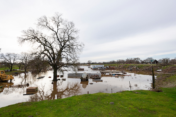
Andrew Innerarity / DWR
“Fallow and sun-baked in the summer, the Cosumnes River comes to life in the wet winter months. Sierra snow melt and valley rains meet at Michigan Bar near Rancho Murieta feeding the waterway for the final leg of its journey through south Sacramento County. Most years the Cosumnes minds its own, winding through broad, flat fields, pastureland and ancient oak groves, farmers and ranchers taking their share. Groundwater seeps into the soil there, filling the taps of the cities to its north and south, booming Elk Grove and smaller cousin Galt. And the river creates home and habitat for thousands of native and migratory birds at Cosumnes River Preserve as it flows into the Delta. January’s record-setting rains have also shown the meandering Cosumnes to be what it has always been — one of California’s last free-flowing rivers and, as such, capable of unstoppable force. … ” Read more from the Sacramento Bee here: How can we keep the waters of the Cosumnes River from flooding Elk Grove and Galt?
‘Looking more promising.’ Floodwaters receding in many Sacramento-area rivers, creeks
“Emergency officials are finally expressing optimism about Sacramento-area rivers and creeks. The Cosumnes and Mokelumne rivers south of Elk Grove are both predicted to remain in a flood monitor stage at least through the weekend, falling comfortably short of flooding. The Cosumnes, in particular, has been a focus for state and local water officials who have repaired thousands of feet of private levees and dispatched multiple flood fighting teams to the area. Three more storms are expected to hit the state over the next week, a forecast that provides some uncertainty to the long-range outlook for waterways like the Cosumnes. … ” Read more from the Sacramento Bee here: ‘Looking more promising.’ Floodwaters receding in many Sacramento-area rivers, creeks
Can our infrastructure withstand a ‘megaflood?’ Here’s what the experts say
“From drought to flood, it’s the vicious cycle of weather extremes in California. It may be hard to imagine more than seven million Californians are at risk of flooding as we enter our fourth year of drought. In fact, in the past 20 years, every California county has received a flood-related emergency. In the second part of our “megaflood” series, we’re looking at why our system of river levees, dams, and reservoirs put the Sacramento and San Joaquin Valleys at one of the top spots in the country for flood risk. “We’re already in a world where the likelihood of a catastrophic flood has doubled in any given year,” said Brian Johnson with the Central Valley Flood Protection Board. “That’s the kind of thing that keeps people like us up at night.” … ” Read more from Channel 10 here: Can our infrastructure withstand a ‘megaflood?’ Here’s what the experts say
SEE ALSO: Where could Sacramento County flood? This interactive map shows risk areas, from the Sacramento Bee
NAPA/SONOMA
Weather roller coast continues on storm-battered North Coast as flood threat persists
“The fallout from two weeks of punishing storms across the North Coast is beginning to become clear even as forecasters warn of new rainstorms and potential flooding ahead. Though the Russian River began receding Tuesday after peaking just below flood stage in the early morning, another round of sustained rainfall predicted to come through Wednesday and Thursday is expected to drive it upward again and reach just above the 32-foot flood stage in Guerneville. That somewhat unwelcome news came as Sonoma County officials announced an initial $11 million estimate in damage to local roads and infrastructure from the storms. The countywide toll was most pronounced in soggy west county. On Salmon Creek Road, east of Bodega Bay, a massive washout left about 15 residents unable to leave their neighborhood. … ” Read more from the Santa Rosa Press Democrat here: Weather roller coast continues on storm-battered North Coast as flood threat persists
No power, no heat: For these Russian River residents, blackout is biggest hardship
“The receding waters of the lower Russian River offered only partial consolation Tuesday to those who are still without electricity here. It’s been a week since intense winds and torrential rain brought down trees and toppled power lines, casting thousands of households across western Sonoma County into darkness. While many of those customers have had their power restored, for many others, the wait goes on. To the flood-hardened residents in communities like Monte Rio, Guerneville and Rio Nido, that has been the biggest hardship — enduring day after day without electricity, poor cell service, cold baths and no heat. … ” Read more from the Santa Rosa Press Democrat here: No power, no heat: For these Russian River residents, blackout is biggest hardship
Sonoma County officials estimate $11 million in initial storm damage
“The onslaught of heavy rain and wind-driven storms over the past two weeks has caused about $11 million in initial damage to local roads and other public infrastructure, Sonoma County officials estimate. Five atmospheric river storms have battered the county since late December and more storms are expected to hit the county before any significant break in the weather, Chris Godley, the county’s emergency management director, said Tuesday as he briefed the Board of Supervisors. He added that the upcoming storms, while still substantial, were not expected to fuel the kind of widespread flooding seen Monday in the region. Estimates show the county’s emergency response has cost about $378,000 to date, including employee overtime, supplies and equipment, Godley said. … ” Read more from the Santa Rosa Press Democrat here: Sonoma County officials estimate $11 million in initial storm damage
BAY AREA
How much rain did San Francisco get from California’s atmospheric river?
“A downpour of rain fell over downtown San Francisco at about 2 a.m. Tuesday as a frontal band barreled across the city and the greater Bay Area. Rivers of rain gushed down roadways in the torrential downpour as winds kicked up. How much rain has the city recorded in this atmospheric river event that first arrived Sunday and is continuing into Tuesday? As of 8:30 a.m., the National Weather Service’s gauge has recorded 1.84 inches since Sunday, forecaster Ryan Walbrun said. … ” Read more from SF Gate here: How much rain did San Francisco get from California’s atmospheric river?
Another pineapple express is rolling into Northern California today. Here are the impacts for the Bay Area
“Following Tuesday’s thunderstorms across Northern California, the storm door is looking to remain wide open today. That’s thanks to a low-pressure system off the coast of the Pacific Northwest that will quickly funnel atmospheric moisture from Hawai’i toward Northern California and the Oregon border. Thankfully, the bulk of that moisture is slated to stay north of the Bay Area, but remnant water vapor from yesterday’s thunderstorms will merge with some of today’s moisture and produce another round of showers in the region. And depending on how intense some of today’s isolated thundershowers become, the excess rain will only slow down the receding floodwaters that have been sitting over low-lying areas and floodplains for days. ... ” Read more from the San Francisco Chronicle here: Another pineapple express is rolling into Northern California today. Here are the impacts for the Bay Area
SEE ALSO:
- Bay Area storm outlook: Here’s when — and where — the next rains will hit hardest
- ‘This place is soaked’: California tallies damage, girds for more rain after deadly atmospheric rivers, from the San Jose Mercury News
Marin storms bring annoyance, anxiety and devastation
“In the last two weeks, Marin County residents have seen storm damage run the gamut — from nasty commutes and soggy yards to washed-out homes and sunken shelter craft. From West Marin to the San Pablo Bay, county residents have endured nearly two weeks straight of daily rain, adding up to more than 18 inches at the top of Mount Tamalpais, 9.01 inches in Tiburon, 16.16 inches in Mill Valley, 16.71 inches in San Anselmo, 8.87 inches in the Point Reyes National Seashore and 8 inches in Dillon Beach since Dec. 28, according to the National Weather Service. Tuesday brought pea-sized hail and scattered thunder and lightning along with the rain and wind as Marin residents fit storm-related chores in between their daily travels. ... ” Read more from the Marin Independent Journal here: Marin storms bring annoyance, anxiety and devastation
‘Don’t jump in puddles’: Sewage is overflowing into San Francisco Bay and city streets during storms
“Millions of gallons of storm water mixed with raw sewage made its way into creeks, the bay and city streets during recent heavy rainstorms that overwhelmed dozens of Bay Area sewers and some treatment plants. Some raw sewage seeped out of manholes or backed up sewer drains, calling into question even the idea of kids splashing in their rainboots. “Don’t jump in puddles. Especially in San Francisco — you want to be careful that there (could be) sewage in that,” said Eileen White, executive officer of the San Francisco Bay Regional Water Quality Control Board, referring to flooded areas when the city’s unique sanitary system that combines storm water and wastewater is backed up during heavy rain. … ” Read more from the San Francisco Chronicle here: ‘Don’t jump in puddles’: Sewage is overflowing into San Francisco Bay and city streets during storms
CENTRAL COAST
California storm destroys popular Santa Cruz beach area, images show
“The storm-related destruction at Seacliff State Beach south of Capitola goes well beyond damage to the cherished wooden pier, as new images from California State Parks show. “People are shocked,” Santa Cruz Public Safety Superintendent Gabe McKenna told SFGATE on Tuesday. “Seacliff State Beach is one of the most popular in Santa Cruz County and the greater Bay Area. Visitation is extremely high. It’s one of those places that’s kind of multigenerational. People have been going there for a long time.”The obliteration of Seacliff Pier in Aptos in last week’s atmospheric river storm has left many in utter disbelief. ... ” Read more from SF Gate here: California storm destroys popular Santa Cruz beach area, images show
Santa Cruz County to begin Pajaro River levee repairs today
“Santa Cruz County officials have observed signs of seepage along an earthen levee of the Pajaro River levee system and will quickly move to engage in emergency repairs, according to a county release Tuesday night. The repairs – set to begin Wednesday morning – will take place in an agricultural section of the levee more than a mile upstream of the confluence of the Pajaro River and Salsipuedes Creek and are expected to take about one week to finish. Known among water engineering experts as a “seepage berm,” the effort will add support and structure to the levee system until levee replacement work previously authorized by the U.S. Army Corps of Engineers begins. County officials say the work is similar to a 1,600-foot repair that was completed in 2017 at a section just south of the currently concerning area. … ” Read more from the San Jose Mercury News here: Santa Cruz County to begin Pajaro River levee repairs today
Monterey Peninsula housing and water: two parts of the same problem
“When the topic of housing needs along the Monterey Peninsula comes up, it’s inextricably tied to water supply, a topic that water experts and housing advocates came together on Monday to try and flush out what the intersection of those critical needs will look like. Until a new, permanent water supply project comes online, a state-ordered moratorium on new water hookups on the Peninsula will stay in place and will do so for anywhere from a couple of years to possibly a decade from now. And without the revocation of the state’s cease-and-desist order that limits the amount of water that can be taken from the Carmel River, new housing for the area isn’t likely to see the light of day anytime soon. … ” Read more from the Monterey Herald here: Monterey Peninsula housing and water: two parts of the same problem
San Luis Obispo County looks toward recovery after the worst of massive winter storm passes
“With the worst of this week’s winter storm now passed, San Luis Obispo County is managing resources and recovery while preparing for future rain. … SLO County Emergency Services Coordinator Rachel Dion said crews are assessing damage across the county. “We’re working with County Planning and Building to get out to all of the homes that were damaged to assess the damage and whether or not those structures can still be inhabited. Our Public Works Crews have been working like crazy — they’re out assessing our roadways that have issues and still working on things like downed trees,” Dion said. … ” Read more from KCBX here: San Luis Obispo County looks toward recovery after the worst of massive winter storm passes
Lake Cachuma expected to fill and spill in wake of major storms
“Swelled by heavy runoff from recent large storms, Lake Cachuma is expected to fill and spill by this weekend, according to Santa Barbara County officials. The lake level continued to rise at the rate of about one foot per hour on Tuesday, and by 7 p.m. was at 78% of capacity, and about 15 feet below spill level, according to the county Public Works Department. “We’ll still be getting inflows to the lake for the next few days,” an obviously happy Matt Young, manager of the county Water Agency, told Noozhawk. … ” Read more from Noozhawk here: Lake Cachuma expected to fill and spill in wake of major storms
Santa Barbara County to conduct sediment-deposit operations at Goleta Beach
“Due to recent rainfall and the increased chance of future storms, the Santa Barbara County Public Works Department will begin sediment deposit operations at Goleta Beach Park. The sediment deposit will start as soon as Wednesday, Jan. 11, and will continue as needed until facilities have been cleared. Operations will occur Monday through Friday. Weekend work may be required to complete the process sooner and minimize beach closures. Santa Barbara County Flood Control Director Walter Rubalcava said, “Monday’s storm delivered a substantial amount of material through the watershed. Most of today will be spent clearing out the rocks and sediment from the basins to decrease the potential for runoff to vulnerable areas during future storms.” … ” Read more from Noozhawk here: Santa Barbara County to conduct sediment-deposit operations at Goleta Beach
SAN JOAQUIN VALLEY
Commentary: San Joaquin Valley at a crossroads
Scott Hamilton writes, “The San Joaquin Valley, its people, its environment, and its economy stand at a crossroads, perhaps even a precipice. For too long the SJV has been drawing on groundwater resources faster than they can be replenished. That condition was simply unsustainable, and it led to implementation of the Sustainable Groundwater Management Act (SGMA) by the California legislature. The Act requires these groundwater resources be sustainable by the year 2040. There are only two ways to achieve sustainability: to decrease demand – requiring the fallowing of vast acreages of productive farmland or increasing the rate of ground water replenishment. The first alternative has dire consequences. … ” Read more from Water Wrights here: San Joaquin Valley at a crossroads
‘Water was coming in our house.’ Residents evacuated amid relentless Merced County storm
“The extreme rainstorm that Merced County has seen over the past days reached a critical stage Tuesday, as some residents fled their homes at a moment’s notice amid rising floodwaters. The Merced County community of Planada is one of the hardest hit, where all residents were evacuated by Sheriff’s Office deputies and other emergency personnel in the early morning hours. In the city of Merced, Bear Creek flooded over its banks. The creek is considered to be at flood stage when it reaches a depth of 23 feet; by Tuesday morning, the creek was at 26 feet. … ” Read more from the Merced Sun-Star here: ‘Water was coming in our house.’ Residents evacuated amid relentless Merced County storm
‘It’s really devastating’: A tiny California town is underwater after storm deluge
“The entire community of Planada, a town of about 4,000 people just east of Merced, was evacuated Tuesday morning amid rising waters from a breached levee. By late morning, street after street was flooded with brown water that sent cars bobbing along like boats, drifting near half-submerged stop signs. Merced County Supervisor Rodrigo Espinosa, who represents the area, said he spent Monday evening trying to lay sandbags in a fruitless attempt to hold back the water. But after several hours, as the water kept rising, it became clear the whole community would have to be evacuated. “We didn’t think it was going to be that bad,” he said of the flood risk. “And there are two more storms coming.” ... ” Read more from Yahoo News here: ‘It’s really devastating’: A tiny California town is underwater after storm deluge
Ceres: River water coming to your tap this year
“While there will be no noticeable difference in taste, filtered water from the Tuolumne River will be piped to Ceres households this summer for the first time ever. The treated river water will be comingled with water pumped from the ground as a project three decades in the making comes to fruition for the cities of Ceres and Turlock. The Regional Surface Water Supply Project was formed in 2011 as the two cities, in cooperation with Turlock Irrigation District, to start the process of building a plant to deliver treated Tuolumne River water to residents. Ceres has been working for 30 years to secure this alternate drinking source, as currently all water from the tap comes from underground aquifers. … ” Read more from the Ceres Courier here: River water coming to your tap this year
Tehachapi: Recent rains have not made much difference with local water situation
“Yes, Tehachapi has received rain and snow during recent storms that hammered areas of the state. But no, the drought is not over and there is not yet any indication that the Department of Water Resources will allocate more water from the State Water Project this year. Tom Neisler, general manager of Tehachapi-Cummings County Water District, shared that grim news with members of the Board of Directors of the district and others gathered for a workshop during a special meeting held Monday afternoon, Jan. 9. The district set the special meeting to discuss the allocation of imported water from the SWP and related matters, including this year’s water priority ordinance. … ” Read more from the Tehachapi News here: Recent rains have not made much difference with local water situation
SOUTHERN CALIFORNIA
L.A. digs out from mudslides, sinkholes and flooding — with another big storm on the way
“Southern California on Tuesday began digging out from a storm that forced mass evacuations, damaged homes, left roads impassable and made a muddy, wet mess of Los Angeles hillside neighborhoods. The system has moved out of the region, but only after landing a powerful punch. The National Weather Service called it “the most impressive” storm since 2005, soaking some parts of the Central Coast with more than a foot of rain. The latest in a series of atmospheric rivers to pound an already drenched California brought astonishing rainfall to L.A. County as well — including more than 6 inches in Bel Air, Porter Ranch, Woodland Hills and Alhambra; more than 5 inches in Beverly Hills, La Cañada Flintridge, Sierra Madre and Pasadena; and more than 4 inches in Agoura Hills and Calabasas. … ” Read more from the LA Times here: L.A. digs out from mudslides, sinkholes and flooding — with another big storm on the way
Column: It’s flooding in Southern California. 85 years ago, the damage was way worse
Columnist Gustavo Arellano writes, “My umbrella was wide and sturdy, my rain slicker insulated and as yellow as a Minion. I wore thick Dickies and my good pair of Doc Martens. It didn’t matter. Just minutes after I stepped out of my Yukon to walk around Parque de los Niños in Placentia’s Atwood barrio last week, I was thoroughly soaked. A strong wind made the rain whip at a 45-degree angle. Drops hit the baseball diamond with such force that mud leaped into the air. At the southern edge of the small park, the water in the Atwood Channel usually amounts to little more than a puddle. But by 9 a.m. that day, with rain coming down hard but not as hard as forecasters had predicted, the concrete wash was a roaring rapids, and rising fast. … ” Read more from the LA Times here: Column: It’s flooding in Southern California. 85 years ago, the damage was way worse
Willowbrook Park, fed by rainwater, is an example of LA’s stormwater treatment future
“The prevailing goal in Southern California has been to get water that falls from the sky away from our roads and buildings as quickly as possible. Much of the rain washes out to the ocean — often carrying trash and other pollutants. The L.A. Times reported up to 10 billion gallons poured into the Los Angeles Basin in recent storms and only about 20% will be captured. “We thought of [stormwater] as a liability as a society,” said waterworks engineer Art Castro at L.A. Department of Water and Power’s Watershed Management Group. “Now we’re moving into, ‘let’s reuse that water. It’s a precious resource’.” … ” Read more from the LAist here: Willowbrook Park, fed by rainwater, is an example of LA’s stormwater treatment future
Landscaping for drought: we’re doing it wrong
“Despite recent, torrential rains, most of Southern California remains in a drought. Accordingly, many residents plant trees prized for drought tolerance, but a new UC Riverside-led study shows these trees lose this tolerance once they’re watered. One goal of the study was to understand how artificial irrigation affects the trees’ carbon and water use. To find out, the researchers examined 30 species of trees spread across Southern California’s urban areas from the coast to the desert. They then compared those trees with the same species growing wild. “We found that, particularly as you move toward the desert regions, the same species of urban trees use much more water than their natural counterparts, even trees considered drought tolerant,” said study lead and former UC Riverside botany graduate student Peter Ibsen, currently with the U.S. Geological Survey. ... ” Read more from UC Riverside here: Landscaping for drought: we’re doing it wrong
Ballona Wetlands night access banned by L.A. City Council
“The Los Angeles City Council voted Tuesday to ban nighttime public access to the Ballona Wetlands in an effort to protect environmentally sensitive areas around the area. The wetlands, the largest remaining wetland habitat in Los Angeles County, have dealt with people lighting campfires and dumping waste, which has caused “significant damage” to the sensitive habitat area, according to the ordinance. The ordinance prohibits people from entering portions of the Ballona Wetlands Ecological Reserve east and north of Playa del Rey and Westchester, west of Lincoln Boulevard and south of the city boundary along Ballona Creek. … ” Read more from CBS News here: Ballona Wetlands night access banned by L.A. City Council
IMPERIAL/COACHELLA VALLEYS
Pacific sea water via tunnel would enable a lithium recovery economic development zone
John Treichler, a retired aerospace engineer, writes, “The above chart depicts the striking water decline at Lake Mead. Dr. Spencer’s analysis concluded that increased usage of Colorado River water, plus La Niña, contribute to the declining level of Lake Mead. Even if La Niña moderates to greater precipitation, increased industrial and city demand for water will result in the continuing decline of Lake Mead. (Trendlines and notes are mine.) Following my column last month proposing a tunnel from the Pacific to provide replacement seawater for the Salton Sea, I received an email from Desert Sun reader Jeff Geraci who had calculated the net evaporation loss from the Salton Sea and concluded that one tunnel from the Pacific would not suffice. He was correct. ... ” Read more from The Desert Sun here: Pacific sea water via tunnel would enable a lithium recovery economic development zone
La Jolla: Local wetlands to get a look in Scripps Oceanography study of carbon storage in coastal ecosystems
“Looking to fill in a missing piece of the climate change puzzle, the work of a former researcher at UC San Diego’s Scripps Institution of Oceanography in La Jolla that studied carbon capture by mangroves in far parts of the world is making its way to San Diego-area wetlands. A Scripps Oceanography-led study published late last year examined how some aquatic ecosystems sequester more carbon from the atmosphere than others and provided an analysis of more than 100 sediment cores from mangrove forests on the Baja Peninsula in Mexico, the Galapagos Islands and the Caribbean and Pacific coasts of Panama. Mangroves are trees that grow in tropical environments and can survive at the edge of the ocean. Moving the work forward, researchers plan in coming months to do fieldwork at San Diego County sites such as San Dieguito Lagoon, Famosa Slough and Kendall-Frost Mission Bay Marsh Reserve to take sediment samples and catalog the amount of carbon stored in them. … ” Read more from the La Jolla Light here: La Jolla: Local wetlands to get a look in Scripps Oceanography study of carbon storage in coastal ecosystems
Along the Colorado River …
Commentary: Department of Interior needs to review agricultural use of water amid negotiations for Colorado River cuts

Bruce Babbitt, former governor of Arizona and former Secretary of the Interior, writes, “As Lake Mead continues to decline toward dead pool, federal officials are requesting the Colorado River states to offer major cuts in water usage. Nevada has responded with a detailed and innovative plan set forth in a December 20, 2022 letter to the Bureau of Reclamation, calling for basic reform of water management throughout the entire Colorado River system. It is centered on protecting water levels in Lake Powell and Lake Mead with new rules for apportioning reduced water deliveries throughout the system. The plan calls on the three lower Basin states, Arizona, California and Nevada, to offer a million and a half acre feet of reductions, in addition to cuts previously agreed upon in the 2019 Drought Contingency Plan (DCP). This new round of cuts calls for “equitable sharing of evaporation and system losses” among the three states in proportion to their “average annual consumptive use for the period 2019 to 2021.” ... ” Read more from the Nevada Independent here: Commentary: Department of Interior needs to review agricultural use of water amid negotiations for Colorado River cuts
In a water deficit, Arizona contemplates a future without Colorado River access
“Water from the Colorado River covers more than a third of Arizona’s total water usage, but the state is increasingly losing access to that supply. The state is no longer in what Terry Goddard, the president of the Central Arizona Water Conservation District Board of Directors, called “a fool’s paradise.” Arizona had maintined a surplus of water since the mid-1980s, but that’s not the case today. Now, it’s losing water, and it’s losing it fast. That loss, and potential future loss, was the focal point of Arizona’s state legislature Tuesday, starting with a presentation from the Central Arizona Project on the status of the state’s water supply in which legislators heard about the tensions between Arizona and other Colorado River Basin states over access to groundwater. … ” Read more from the Courthouse News here: In a water deficit, Arizona contemplates a future without Colorado River access
Arizona: ‘All groundwater is spoken for’: New West Valley construction can no longer rely on groundwater after release of new report
“The middle of Arizona is turning grey. The brown desert landscape has been sprawling into a metropolitan expanse for decades, spreading outward in every direction from central Phoenix. The Valley welcomes a new resident every six minutes, and with them come new development. That spread may greatly slow or even stop in the West Valley after the Arizona Department of Water Resources (ADWR) released a new report on Monday. All of the groundwater in the nearby Hassayampa sub-basin is spoken for, the report found. Any new home builders in the area who haven’t already been approved will have to bring in their own source of water. ... ” Continue reading from Channel 12 here: Arizona: ‘All groundwater is spoken for’: New West Valley construction can no longer rely on groundwater after release of new report
Hobbs faces tough GOP resistance, crucially on groundwater
Columnist Tim Steller writes, “Much is routine about an Arizona governor’s state of the state speech, whether the officeholder is a Republican or Democrat. They talk about improving education. They say we have a good business climate, but it still needs to improve. They reference the federal government’s failures on immigration and at the border. The approaches and details vary, of course, but the broad swaths tend to stay the same. After reading about Monday’s state of the state speech in the Capitol and watching a new version at the Tucson Convention Center on Tuesday, I noticed two new details, though: One is about Republican legislators, the other is about perhaps the state’s biggest issue — water. … ” Read more from the Arizona Daily Star here: Hobbs faces tough GOP resistance, crucially on groundwater
‘It’s our livelihood’: Rio Verde residents protest Scottsdale’s decision to stop water supply
“Time is running out for those who live in the Rio Verde Foothills. On January 1, the city of Scottsdale officially stopped transporting water to the community, which means residents are now counting down the days until their taps run dry. On Tuesday, they took their fight to the city’s first council meeting of 2023. Mayor David Ortega welcomed new and returning councilmembers to City Hall as family, friends, and other city officials cheered on. Outside though, celebrations turned to frustration as a crowd gathered, hopeful for change. “I’m really pissed off,” said Jessica Mehlman. “It’s just human decency.” … ” Read more from Channel 12 here: ‘It’s our livelihood’: Rio Verde residents protest Scottsdale’s decision to stop water supply
Explaining water flows: Why Sierra Nevada snow won’t fix Lake Mead
“A big snowstorm in California is welcome news, as long as floods and mudslides aren’t wrecking lives. Snow and rain bring some relief from the drought, but it matters where the snow falls. The current storms are drenching central California and dumping snow in the Sierra Nevada, the beautiful mountain range that’s home to national parks and scenic mountain trails and roads. That snow is never going to make a difference at Lake Mead — the focal point of the 23-year “megadrought” gripping the desert Southwest. … ” Read more from KLAS here: Explaining water flows: Why Sierra Nevada snow won’t fix Lake Mead
Wyoming: State legislators look to create a commission for Wyoming’s stake in the Colorado River
“The Wyoming State Legislature begins its lawmaking session this week. One bill, called the “Colorado River Authority of Wyoming Act,” would create a board and commissioner to manage Wyoming’s water in the Colorado River Basin. The system drains about 17 percent of the Cowboy State’s land area and is critical for agriculture, energy development and residential use in cities. The entire Colorado River Basin is currently under stress due to drought conditions and human development in the Southwest. The bill, sponsored by Rep. Albert Sommers (R-Pinedale) and Sen. Larry Hicks (R-Baggs) is similar to those previously passed in several other states that depend on the Colorado River. “We feel it’s very important to have those people that are actually going to be affected that live in the Colorado River Basin [to] have an opportunity to participate in these policy-level decisions that’s going to affect your everyday life,” Hicks said. … ” Read more from Wyoming Public Media here: Wyoming: State legislators look to create a commission for Wyoming’s stake in the Colorado River
Lake Powell water level stagnates despite rain
“Unusually wet weather has spread through Utah and Arizona this week. But the rain and snow have done nothing to raise the water level that is currently at a record low in the nation’s second largest reservoir. Lake Powell has missed out on most of the heavy rain in the last few weeks but slight improvements have already been seen in water levels at neighboring Lake Mead. It is hoped that continued rainfall will improve water levels for Lake Powell. However, heavy rainfall will need to be sustained over a prolonged period to have any significant effects on water levels. … ” Read more from Newsweek here: Lake Powell water level stagnates despite rain
In national water news today …
Final rule seen as muddying waters for ag landowners
“In its latest attempt to define which bodies of water fall under federal protection, the U.S. government said its new rule would provide more certainty for farmers and other landowners. But farm groups say the new “Waters of the United States” rule, or WOTUS, will only create more confusion and cause disruptions to routine agricultural activities. They previously called on the Biden administration to halt its rulemaking until after the U.S. Supreme Court weighs in. Instead, the U.S. Environmental Protection Agency and the U.S. Department of the Army late last month finalized the rule, which updates which “navigable waters” are subject to regulation under the Clean Water Act. … ” Read more from Ag Alert here: Final rule seen as muddying waters for ag landowners
Navigable waters: The Supreme Court case that could upend the Clean Water Act
“Everyone wants clean water, and America’s public waterways haven’t always been very clean. In 1969, the Cuyahoga River in Ohio was so polluted by Cleveland’s manufacturing industry that it caught on fire, which inspired a Time magazine feature describing a river that “oozes rather than flows.” In 1970, President Richard Nixon signed the National Environmental Policy Act, and later that year he established the Environmental Protection Agency (EPA) to “make a coordinated attack on the pollutants which debase the air we breathe, the water we drink, and the land that grows our food.” But in fighting to reduce the pollution of air, land, and water, the EPA has dictated to Americans what they can do on their property even when it has no clear environmental benefit or exceeds the agency’s authority. Now the agency’s broad mandate, for the first time since its creation, is facing a serious court challenge. It’s a case that started 15 years ago with a couple living in a small town in Idaho. … ” Read more from Reason here: Navigable waters: The Supreme Court case that could upend the Clean Water Act
Record drought gripped much of the U.S. in 2022
“The large coverage and long duration of drought conditions across the U.S. set several records in 2022. The year was also marked by numerous severe weather events, devastating hurricanes and deadly flooding across parts of the country. Here is a summary of the climate and extreme weather events across the U.S. in 2022 … ” Read more from NOAA here: Record drought gripped much of the U.S. in 2022
The year ahead in water and drought
“Don’t be fooled by the massive storms and floods hitting California right now: The U.S. (and California in particular) was pretty damn dry in 2022, and it’s likely that 2023 will be another dry year.The American West has wilted under a megadrought —the worst drought that region has seen in over 1,000 years. Scientists have connected this drought to rising temperatures that have been partially fueled by human activity. The Colorado River, which provides water to seven states and about 40 million people, has seen dwindling water levels for years, but things got really bad in 2022. Reservoirs along the river, like Lake Mead and Lake Powell, have seen historically low water levels, receding so badly that several sets of human remains were found at Lake Mead. … ” Read more from Gizmodo here: The year ahead in water and drought
Microplastics: Size does not matter
“The recent storm littered local beaches with driftwood and trash. Plastic pieces of all sizes tumbled in the surf and settled into the rubble. But the storm didn’t bring the plastic—it just highlighted its existence. Some of the particles will get picked up by volunteers and mindful beachgoers. But lots of it will wash back out to sea and break down into smaller and smaller pieces. When it degrades to less than five millimeters long—about the size of a pencil eraser—it’s microplastic. In a recent study, scientists found microplastics inside an alarming number of seabirds and anchovies from Monterey Bay. The research, published in the scientific journal Environmental Pollution, also suggested that some particles could disrupt hormones, potentially spelling trouble for wildlife populations. … ” Read more from Good Times here: Microplastics: Size does not matter
Global ocean temperatures hit new record in 2022
“The world’s oceans hit their highest temperatures in recorded history, according to a study published in the journal Advances in Atmospheric Science on Wednesday. For the study, 24 scientists across 16 institutions worldwide analyzed observations of ocean heat content and its impact dating back to the 1950s. They found that changes in Earth’s ocean heat content, salinity and stratification — the separation of water into layers — provide vital indicators for changes in heat distribution and the hydrological cycle. “First of all, the oceans hold the key to the climate. The oceans are what absorb almost all of global warming heat. So, if you want to know how fast the Earth is warming, the answer is in the oceans. If you want to know what our future climate is going to look like, the answer is in the oceans,” said John Abraham, study co-writer and professor of mechanical engineering at St. Thomas University. … ” Read more from the Courthouse News Service here: Global ocean temperatures hit new record in 2022
Also on Maven’s Notebook today …
SAVE THE DATE: Mono Lake Workshop on February 15, 2023
UPDATE: All Curtailments in the Delta Watershed Remain Temporarily Suspended
FUNDING OPPORTUNITY: CDFW Cannabis Restoration Grant Program: 2023 Proposal Solicitation Notices Are Open for the Qualified Cultivator Funding Opportunity (QCFO) and the Cleanup, Remediation, and Watershed Enhancement (CRWE) Funding Opportunity

