

Article written by Robin Meadows, Estuary News
In just a few years, tracking the West Coast’s atmospheric rivers by airplane has gone from what one hydrologist called “really-wild-eyed stuff” to a Congressionally-funded operation. This Atmospheric River Reconnaissance program, which wrapped up its latest season in March, monitors these increasingly powerful storms as they shoot across the Pacific Ocean and delivers real-time data to National Weather Service forecasters. Knowing when, where and how hard atmospheric rivers will hit is vital to ensuring water supplies and avoiding floods.
“California can swing from 20 inches to 60 inches of rainfall per year,” says Atmospheric River Reconnaissance lead Marty Ralph, a research meteorologist at Scripps Institution of Oceanography. “We’re very different from the rest of the country — that’s why we need a special program.”
Atmospheric rivers are ribbons of water vapor that form in the tropics and are so wet they’re close to 100% humidity. They can also be amazingly long at up to 5,000 kilometers from end to end — stretching halfway across the Pacific — as well as quite narrow at just a few hundred kilometers from side to side. These exceptionally moist storms can come in fast, moving at up to 100 kilometers per hour. The biggest atmospheric rivers carry enough water vapor to match the daily outflow of the Amazon River and, once over land, can release a torrent of rain and snow for three days in a row.
Not every atmospheric river is fearsome. “They can be beneficial,” says Alan Rhoades, a hydroclimate scientist at Lawrence Berkeley National Laboratory. They deliver about half of the West’s precipitation, replenishing reservoirs as well as the mountain snowpacks that store much of the region’s water. “But,” he continues, “they can also be hazardous.”

Atmospheric rivers cause most of the flooding in the West, with economic damages reaching $1 billion a year. And these storms will likely be even more intense as the world warms. Bigger, wetter atmospheric rivers will heighten the risks of catastrophic flooding and landslides, as well as of levee breaches in the Sacramento-San Joaquin River Delta, threatening the state’s water supply. A new 1-5 scale categorizes the potential of an atmospheric river to help or harm.
Warming will likely shift the West Coast’s atmospheric rivers towards the higher, more hazardous end of this scale, according to a 2021 study in Weather and Climate Extremes led by Rhoades. The researchers compared landfalling atmospheric rivers in future worlds with varying degrees of warming to those in a past, pre-industrial world without climate change. “For every degree of warming, atmospheric rivers were 15% larger and lasted six hours longer,” Rhoades says, explaining that air can hold more water vapor as temperatures rise.
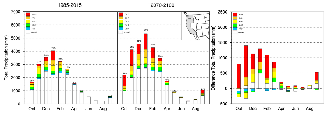
On the 1-5 scale, the average atmospheric river intensified from a 1.8 in the pre-industrial world to a 2.4 in a future world that is 3 ⁰C warmer. The researchers also found that this climate scenario quadrupled the prevalence of category 4 and 5 — the most hazardous — atmospheric rivers and tripled flood damages.
Back-to-back atmospheric rivers could also be more common in a warmer world. This could complicate current efforts to manage surface water more effectively. These efforts include Forecast Informed Reservoir Operation (FIRO), which uses atmospheric river predictions to determine whether it’s safe to keep water in a reservoir or whether it should be released to make room for stormwater, and Flood-Managed Aquifer Recharge (Flood-MAR), which conveys water to agricultural fields or flood plains for percolation into an aquifer.
“Back-to-back atmospheric rivers could hamper the effectiveness of FIRO combined with managed aquifer recharge,” Rhoades says, explaining that if storms are too close together, there may not be enough time to convey reservoir releases to recharge sites. This could increase the risk of flooding near the reservoir.
Oroville Orwellian in Retrospect
When atmospheric rivers come in pairs, the combination can be on the hazardous end of the scale even if the individual storms would be at the beneficial end on their own. “The first primes the soil with moisture and the second, even if it’s a low category, could cause flooding,” Rhoades explains. A one-two atmospheric river punch contributed to the February 2017 Oroville Dam crisis, when spillway damage led to fears of catastrophic failure and flooding, and evacuation of 188,000 people downstream of the reservoir along the Feather River.
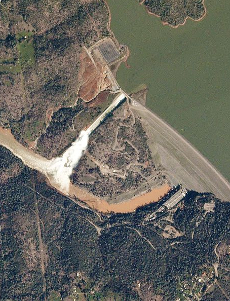
New research shows that climate change also contributed to the Oroville Dam incident. The first storm pulse saturated the soil at lower elevations in the Feather River Basin, and also piled a lot of new snow on an already deep snowpack in the upper basin. The second pulse was much warmer than the first, dropping rain on all that snow. The ensuing rush of water, up to half of which was snowmelt, came as a surprise.
This atmospheric river had been forecast as moderate two days before landfall and as strong one day before landfall. But the storm actually turned out to be extreme. “There was a lot more runoff than predicted,” says Alexander Gershunov, a climate scientist at Scripps Institution of Oceanography who is a co-author on the study, which was reported in 2022 in Earth’s Future. “The reservoir was already so full it couldn’t contain much more water.”
Gershunov and colleagues assessed the impact of global warming on the two storm pulses by modeling their precipitation in climate epochs ranging from pre-industrial to modern day to the end of this century. The researchers estimated that today’s warming increased the Feather River Basin’s precipitation by 11% for the initial pulse and 15% for the second pulse. Under the worst case business-as-usual warming scenario, these figures rose to 21% and 59%, respectively, by 2100.
“Documenting the contribution of climate change to a specific extreme event is important,” says Gershunov. “It’s something people can relate to.”
Next he’d like to document how much the warming-driven precipitation increase contributed to the gush of runoff into Lake Oroville, as well as the total economic impact of the crisis. While dam repairs ran about $1 billion, the private costs incurred by the many people forced to evacuate are unknown.
River Recon
Figuring out what to expect from an incoming atmospheric river is hindered by gaps in weather data. These storms travel so low, typically skimming just a couple of kilometers above the Earth’s surface, that they are often obscured from satellites by high-elevation clouds. The Atmospheric River Reconnaissance (AR Recon) program is filling these data gaps.
“We need to know how much moisture is coming in and how fast,” says AR Recon field research manager Anna Wilson, a Scripps Institution of Oceanography environmental engineer. “The goal is to better predict precipitation over land — how much, where, how long it’ll last, and whether it’s coming as rain or snow.”
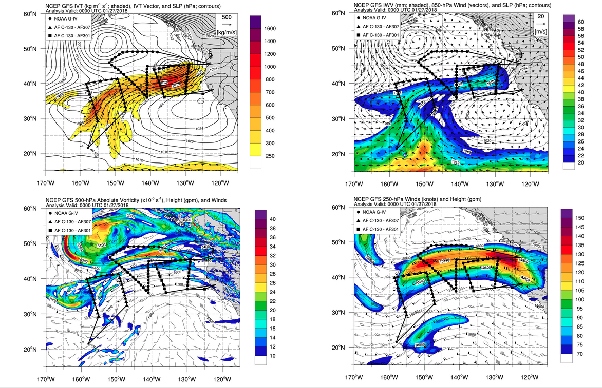
Since launching as a pilot program in 2016, AR Recon has expanded the number of atmospheric river monitoring missions from three during its first season to as many as 30 in recent seasons. Tracking these storms takes up to three airplanes, two stationed in California and one in Hawaii, which is near where many of the West Coast’s atmospheric rivers start.
“We need to be able to cover a lot of ground,” Wilson explains. “Atmospheric rivers can take different shapes, sizes, and orientations, so the forecast can jump around.”
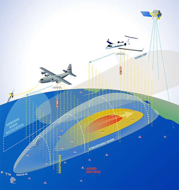
The airplanes fly out to meet the storm, zooming above it as high as 40,000 feet (about 12 kilometers) and dropping weather instruments called dropsondes down into it. Dropsondes take readings of water vapor, wind and temperature at a rapid clip until they hit the ocean, transmitting a nearly continuous stream of data that weather forecasters use in real time.
Other AR recon instruments include drifting buoys that measure air pressure and water temperature at the sea surface and, like dropsondes, transmit data in real time. A more recent, experimental addition to AR Recon is a technique called airborne radio occultation, which measures the moisture and temperature downwards along the path of the airplanes.
“It’s a perfect complement to the dropsondes,” Wilson says. Airborne radio occultation gives weather profiles lengthwise along the side of an atmospheric river, while dropsondes give profiles across its width.
“All the atmospheric river action is at low levels but the surrounding atmospheric processes affect them,” Wilson continues. “Observations both in and outside of atmospheric rivers will help us understand where they might move and when they might change direction or stall.”
Did it Work? What Next?
As an initial test of whether all this AR Recon information translates to better weather predictions, researchers assessed how dropsonde data affected atmospheric river forecasts. The team compared the accuracy of forecasts both with and without dropsonde observations, an approach called a data denial experiment, for 15 storms tracked during the first few years of the program. “Running a model with and without the observations tells us did we help, and how?” explains Wilson.
The study, reported in 2021 in JGR Atmospheres, showed that dropsonde data increased the accuracy in predicting how much moisture these 15 atmospheric rivers carried (intensity) and how much rain and snow they dropped after landfall. “The AR Recon data reduced the error in forecasting intensity by up to 25% and precipitation by up to 20%,” says study co-author Zhenhai Zhang, an atmospheric scientist at Scripps Institution of Oceanography.
Similar data denial studies are now underway to assess AR Recon’s impact on advancing the lead time for predicting these storms as well as on pinpointing where they will make landfall. Currently, landfall forecasts that are three days out can be off by 400 kilometers.
“Atmospheric rivers are a relatively young science,” Zhang points out. First recognized in the 1990s, this type of storm has only been studied intensively for about a decade. “There are so many things we need to know about atmospheric rivers,” he continues. “It’s a hot topic.”

More AR Recon instrumentation would help. Inspired by a similar program in the Atlantic Ocean, Wilson hopes to add weather balloon releases from what she calls “ships of opportunity,” which are vessels that just happen to be traveling under atmospheric rivers.
“It would be awesome to do it here in the Pacific too,” she says. Weather balloons provide data similar to that from dropsondes but in the opposite direction, starting at the ocean surface and ascending through an atmospheric river from bottom to top. Then the balloons keep rising until they burst at roughly 80,000 feet, collecting information all that way up on conditions that can affect atmospheric rivers.
Extending the AR Recon season would help too. Ideally, program lead Marty Ralph would like to start in November, two months earlier than usual. Tracking now runs from January through March, which is when atmospheric rivers have historically peaked in California.

But the really scary storms can also hit much earlier in the rainy season, as the Bay Area’s record-breaking atmospheric river in late October 2021 shows. That astonishing downpour dumped 4 inches of rain on San Francisco and 7.8 inches on Santa Rosa in a single day, flooding roads, cutting power, and driving people from their homes, as well as disrupting flights across the West.
Ralph also wants to extend AR Recon geographically, basing an airplane in Japan as well as in Hawaii. While many atmospheric rivers begin near the Hawaiian Islands, the waters near Japan are even more of a hot spot for creating these storms. And the latter storms are often more costly. Atmospheric rivers with economic damages upwards of $20 million tend to start closer to Japan, shows a 2021 Geophysical Research Letters study co-authored by Ralph.
“Some of the most destructive atmospheric rivers cross the whole Pacific,” Wilson says. This is partly because these storms travel further across the ocean before reaching the West Coast, scooping up more water vapor and so becoming wetter and wetter en route. Ralph acknowledges that his dream of tracking storms from Japan is “super ambitious” — but the payoff could be huge.
This story was produced by Estuary News Group and co-published by Maven’s Notebook under a grant for in-depth science coverage supported by the Delta Stewardship Council.
Related Estuary Stories
Recent Science
- Climate Change Enhanced Atmospheric River, Contributing to Oroville Dam Crisis, AGU Feb 2022: https://agupubs.onlinelibrary.wiley.com/doi/full/10.1029/2021EF002537
- Improved Forecast Skill Through the Assimilation of Dropsonde Observations From the Atmospheric River Reconnaissance Program-AGU-October 2021: https://agupubs.onlinelibrary.wiley.com/doi/full/10.1029/2021JD034967
- Genesis Locations of the Costliest Atmospheric Rivers Impacting Western US, AGU Sept 2021: https://agupubs.onlinelibrary.wiley.com/doi/abs/10.1029/2021GL093947

