

On the calendar today …
- PUBLIC WORKSHOP: Nutrient Management beginning at 9am. The State Water Resources Control Board will hold a public staff workshop to present information on the impact of nutrient discharges on inland and ocean waters and activities underway or planned to address nutrients. Click here for the full meeting notice.
- CEQA SCOPING MEETING: Tuolumne River Voluntary Agreement beginning at 10am. The State Water Resources Control Board will be the lead agency and is planning to prepare a staff report, including a substitute environmental document (SED) and a report documenting the scientific basis for consideration of potential updates to the Water Quality Control Plan for the San Francisco Bay/Sacramento–San Joaquin Delta Estuary (Bay–Delta Plan) to incorporate a proposed voluntary agreement for the Tuolumne River (Tuolumne River Voluntary Agreement). Click here for the notice.
- WORKSHOP: California Water Plan Update 2023 – Desalination Resource Management Strategy from 10am to 12pm. The California Water Plan describes and updates a broad set of resource management strategies (RMSs) that help local agencies and governments manage their water and related resources. Every RMS can be a technique, program, or policy that can be used to meet water-related management needs of a region and the state as a whole. During this workshop, the Water Plan Team will gather comments on the draft Desalination RMS. This will be an online only workshop, please register to receive the link.
- WEBINAR: Treatment strategies for PFAS in water reuse from 11am to 12pm. Per-and-polyfluoroalkyl substances (PFAS) pose a challenge to many water reuse applications due to concerns about potential contamination of soils and groundwater. Impending U.S. EPA rulemaking is making removal of PFAS for potable reuse projects particularly critical. Join us on Thursday, May 18 to learn from the experts about the impact of PFAS on water reuse, potential mitigation strategies, and what you need to do to be prepared for new regulations. Click here to register.
- WEBINAR: What are Californians doing about…Weather Whiplash? from 12pm to 1:30pm. Californians are living through record-breaking extreme weather, from crippling drought to dangerous flooding. How is state government adjusting to these intensifying climate extremes? How can our state continue to thrive as the dryer periods become dryer, and the wetter periods become wetter? What investments, policies programs are needed? What can everyday Californians do? Join scientific experts and state leaders unpack and discuss this critical topic. Click here to register.
- SCOPING MEETING: Imperial Streams Salton Sea & Tributaries Feasibility Study from 1pm to 3pm. The U.S. Army Corps of Engineers in partnership with the Salton Sea Management Program and the Salton Sea Authority, are hosting two virtual public scoping meetings to begin a new feasibility study. Zoom Link: https://bit.ly/SaltonSeaMeeting
- MEETING: Delta Protection Commission from 4pm to 7pm in Oakley. Agenda items include the Executive Director’s report, Delta Leadership program presentation, Delta Watermaster update, and Delta Protection Advisory Committee report. For the full, click here.
- SCOPING MEETING: Imperial Streams Salton Sea & Tributaries Feasibility Study from 5:30pm to 7:30pm. The U.S. Army Corps of Engineers in partnership with the Salton Sea Management Program and the Salton Sea Authority, are hosting two virtual public scoping meetings to begin a new feasibility study. Zoom Link: https://bit.ly/SaltonSeaMeeting
- GRA CENTRAL COAST BRANCH: How Have Central Coast Groundwater Levels Responded to 2023’s Historic Rainfall? from 6pm to 8pm. Want to see how the Central Coast’s groundwater basins have responded to this year’s historic rainfall? Come attend our May 18th, 2023, Central Coast GRA Branch Meeting to get a sneak peek at results from Spring 2023 groundwater monitoring programs for groundwater basins in Ventura, Santa Barbara, and San Luis Obispo Counties. Click here to register.
In California water news today …
Proposed reservoir in Northern California would boost Folsom Lake water storage
“No matter if it’s a dry year or wet year, there are continued pleas for more water storage. Now, an American River Basin study is showing how a strategically placed high Sierra reservoir might be part of the water solution. The concern to capture Sierra runoff is seeing increased interest as California experiences even bigger climate whiplash years – going from droughts to floods. The big snowpack in the Sierra this year stands out as an anomaly with climate models forecasting more rain than snow falling in the lower mountains by the end of the century. The other concern is the earlier runoff and having to store and manage reservoir water over a longer period of time through the dry summer months. To help ease that tension, a new reservoir is being considered near Alder Creek in the Sierra. This is just above Pollock Pines in El Dorado County just off Highway 50. … ” Read more from Channel 10.
Newsom chides McCarthy over California water money
“Gov. Gavin Newsom is ramping up his pressure campaign against Republicans as a slow-moving natural disaster hits a conservative-leaning region of California. And the Democrat is using a perennial Republican calling card — water funding — to drive home his message. Newsom, who has grown increasingly frustrated over the lack of federal action, is casting Republicans as unwilling to fund critical flood protection in the Central Valley, where record snowmelt has already submerged farms and will continue to threaten communities into the summer, while California steps up to front the money. Now, he’s singling out House Speaker Kevin McCarthy and Rep. David Valadao, who represent the region, in a letter shared with POLITICO that marks an unusual escalation for a governor more used to calling out his foes in speeches and tweets than issuing stern, behind-the-scenes appeals for their cooperation. … ” Read more from Politico.
Efforts to recharge California’s underground aquifers show mixed results
“From extreme drought to extreme floods, this is what California is experiencing this year after a series of epic winter storms. And it’s a window into the state’s climate future. You see, California is trying to capture as much water in wet years like this one as it can, and its biggest storage container is underground. But as NPR’s Nathan Rott reports, in the largely developed Central Valley, it’s hard to figure out how to get water there. … ” Listen or read transcript from NPR.
Friant-Kern Canal fix raising flows, hopes of more water infrastructure projects
“A major project that will enhance California’s water delivery system is moving along in the form of repairing the Friant-Kern Canal. Friant Water Authority Chief Operating Officer Johnny Amaral spoke with The Sun for Wednesday’s episode Sunrise FM to provide an update on the project, among a variety of other water-related issues. The backstory: Around six years ago, the Friant Water Authority, which operates the Friant-Kern Canal, noticed a major problem throughout a 30-mile stretch between Porterville and Delano. The canal was suffering from an issue called subsidence, which is the sinking of the ground due to decades of groundwater overdraft. … ” Read more from the San Joaquin Valley Sun.
Water whiplash: See how California’s drought disappeared in a few months
“California has been on an amazing roller coaster of drought and floods recently. The three years from 2020 to 2022 were the driest three-year period in the state’s recorded history, breaking the old record set during the previous drought from 2013 to 2015, according to the state Department of Water Resources. But after a deluge this winter, reservoirs are full. Wildfire risk has dropped. Groundwater tables in many areas have risen. The Sierra snowpack, the source of 30% of California’s water supply, was at 324% of normal on Thursday, the highest level in 40 years. The extreme swings have been documented each week in color-coded maps issued by the U.S. Drought Monitor, a weekly report by the NOAA, the USDA and the University of Nebraska. … ” Read more from the San Jose Mercury News (gift article).
New research: Climate impacts widespread across California, fueling worries over water supply
“As water system managers across California devise strategies to help secure their water supply, they often face a major obstacle to implementing those measures: a lack of interest or will to act among community members. “One of the things that the literature has found is that even if water system managers and local decisionmakers are really worried about climate change and water security, a lot of the adaptation strategies that they have in their toolbox actually require support from residents,” said Kristin Dobbin, a UC Cooperative Extension specialist focused on water justice planning and policy. Because popular support is essential for realizing many water-related adaptations – from changing the rate structure to approving bonds for new infrastructure – Dobbin and her colleagues recently published a paper looking deeper at residents’ experiences of, and concern about, climate impacts to household water supply. … ” Read more from The Confluence.
Newsom touts $60-million plan for ‘fishway’ along Yuba River; critics say it falls short
 “Citing the need to boost survival rates for imperiled salmon and sturgeon along the heavily dammed Yuba River, state, local and federal officials have announced a $60-million plan to build a channel that will allow fish to swim easily around a dam that has impeded their passage for more than a century. Joined by Gov. Gavin Newsom on Tuesday, officials announced that the fishway would bypass the DaGuerre Point Dam, in Marysville, and allow spring-run chinook salmon, green sturgeon, steelhead, and lamprey to access 10 to 12 miles of spawning habitat upstream. “The fishway at DaGuerre Point will be an unprecedented action to restore habitat and contribute to the recovery of threatened species by providing unobstructed passage to habitat that’s been incredibly challenging for them to access,” said Willie Whittlesey, general manager of the Yuba Water Agency. … ” Read more from the LA Times. | Read via AOL News.
Partnering to restore the Yuba River for native fish and water supply
“It was a great moment on the Yuba River yesterday when Yuba Water Agency joined Governor Newsom and state and federal fish and wildlife agencies to advance an ambitious restoration effort that will reopen habitat to multiple native fish species and promote the return of spring-run Chinook salmon to their native habitat in the North Yuba River for the first time in more than 100 years. This restoration effort will include a new fishway–a channel resembling a natural river that salmon, steelhead, sturgeon and lamprey can follow to get around the U.S. Army Corps of Engineers’ Daguerre Point Dam to reach more than 10 miles of healthy spawning habitat, as well as a water diversion to supply irrigation water south of the lower Yuba River that will protect fish passing the intake. It also includes initiation of a comprehensive reintroduction program to support recovery efforts of spring-run Chinook salmon with a goal of returning them to their original habitat in the North Yuba River above New Bullards Bar Reservoir as soon as 2025. … ” Read more from the Northern California Water Association.
Groups, Tribes left out of Yuba River fish passage plan as salmon-killing water projects forge ahead
Dan Bacher writes, “In a widely-broadcasted press conference held on the banks of the lower Yuba River yesterday, Governor Gavin Newsom, the Yuba Water Agency, the California Department of Fish and Wildlife (CDFW) and the National Marine Fisheries Service (NMFS) announced a controversial plan to build a fish passage canal around Daguerre Point Dam and begin a reintroduction trap-and- haul effort around New Bullards Bar Dam. Shockingly, no representatives of fishing groups, environmental groups and Tribes were invited to be part of the negotiations for the restoration effort nor invited to the press conference by a state government that has constantly gushed about “inclusion” and “diversity” but has done the very opposite in practice. … ” Read more from the Daily Kos.
New report finds proposed Delta Tunnel could bankrupt Metropolitan Water District
“In a report sponsored by the California Water Impact Network, policy expert Max Gomberg revealed that the continued funding of the controversial Delta Tunnel – also known as the Delta Conveyance Project – could bankrupt the powerful Metropolitan Water District of Southern California. Gomberg is the former climate change and water conservation manager for the State Water Resources Control Board. According to Gomberg, the embattled attempt to build a giant tunnel under the Sacramento-San Joaquin River Delta “threatens MWD’s fiscal solvency, promises dramatically higher ratepayer bills, and does nothing to secure long-term water security for the 19 million residents within the district’s service area.” Gomberg discussed his report and fielded questions from reporters in a press conference on May 9. … ” Read more from the Sacramento News & Review.
Drinking water at 1 in 4 California child-care centers tests dangerously high for lead
“In test results that suggest thousands of California infants, toddlers and children continue to be exposed to brain-damaging lead, data released by the state Department of Social Services has revealed that 1 in 4 of the state’s child-care centers has dangerously high levels of the metal in their drinking water. Lead, a potent neurotoxin that poses a particularly grave threat to children, was discovered in the water systems of nearly 1,700 child-care centers licensed by the state. The highest results came from a facility in San Diego that recorded 11,300 parts per billion at the time of testing — well above the state’s limit of 5 ppb in child-care centers. One ppb is the equivalent of one drop of contaminant in 500 barrels of water. … ” Read more from the LA Times.
SEE ALSO: Dangerous levels of metal found in water at California child care centers. Search our data, from the Sacramento Bee
Valley congressman fighting for water rights, transit needs
“Congressman John Duarte, a freshman Republican lawmaker who represents the new 13th District, which includes Ceres, as well as some surrounding neighborhoods, and reaches up to Lathrop, down through Patterson and Mendota, and into Coalinga in Fresno County, sat down for an update on his first months in office. … Q: You have some really important committee appointments — Transportation Infrastructure, Agriculture and Natural Resources. Tell us about those. … A: In the Natural Resources Committee, I am on the Water Subcommittee which is Water, Wildlife and Fisheries and that’s where we deal with endangered species issues, we deal with water policy. We just pushed to pass David Valadao’s WATER for California bill, which is very important. I sit on that committee with Tom McClintock and Doug LaMalfa, again from up north, and in that committee we will really have it out. The Democrats in that committee tend to be to the left and a lot of the Republicans in that committee tend to be from rural areas. … ” Read more from the Ceres Courier.
DWR launches ‘Be Well Prepared’ program to ensure safe and reliable drinking water for households and communities dependent on groundwater
” DWR today announced the official launch of the new Be Well Prepared program that provides information and resources to help well owners, well users, and local agencies be ready for impacts of climate-driven weather extremes on groundwater supplies and drinking water wells. Groundwater is a critical component of California’s water supply and is heavily relied upon by communities, agriculture and the environment, especially during dry and drought years. While California’s surface water conditions have greatly improved thanks to recent storms, many communities across the state that rely on groundwater basins are still experiencing drinking water impacts from three years of extreme drought. Being well prepared empowers well owners, as well as state and local agencies, to understand local groundwater conditions, identify areas where drinking water supplies may be at risk and know how to access and allocate assistance when and where it is needed. … ” Read more from DWR News.
DWR delivers $143.7 million to local communities to address regional water supply challenges and build climate resilience
“To help empower local communities and address impacts caused by climate change, the Department of Water Resources (DWR) has awarded $143.7 million to implement 115 projects that support groundwater recharge, strengthen flood management, increase water conservation and improve water quality through the Integrated Regional Water Management (IRWM) program. “California’s changing climate presents unique challenges to our regions across the state,” said DWR Director Karla Nemeth. “These projects meet multiple needs including constructing new water infrastructure, improving water quality, protecting wildlife and preparing for a hotter and drier future. Equally important, they leverage local, federal and other state dollars to help ensure water security for all Californians is affordable.” … ” Read more from DWR News.
Governor Newsom signs executive order to support ongoing Central Valley flood response
“In response to the latest runoff conditions and flood impact modeling, Governor Gavin Newsom today signed an executive order updating and extending recent emergency actions to allow expedited floodwater diversion, debris removal, levee repairs and other flood preparation and response activities in the Tulare Lake and San Joaquin River Basins, and to allow diversion of floodwater for groundwater recharge purposes statewide. Today’s order extends to the San Joaquin River Basin floodwater diversion waivers included in a prior executive order covering the Tulare Lake Basin. The San Joaquin River Basin may face increased flood risk as the historic snowpack in the Sierra Nevada continues to melt. The order includes refined requirements for new flood diversion and groundwater recharge efforts in the Tulare Lake and San Joaquin River Basins to protect water quality, infrastructure and wildlife habitats. … ” Read more from the Office of the Governor.
California’s wet winter fueled flowers, but will also fuel wildfires
“In California’s Central Valley, vibrant wildflower blooms are drying into brittle fuel for wildfires. Now land managers and property owners are under deadlines to clear brush and mitigate risk before peak fire season later this year. The state’s wet winter, which saw nearly two years-worth of precipitation, resulted in a so-called super bloom blanketing the low hills of the state’s valleys with yellow fiddlenecks, purple lupine and orange California poppies. Tourists flocked from all over the U.S. and the world to see them, and satellite photos even captured their colorful streaks from space. … ” Read more from KSBY.
Today’s featured article …

SoCAL WATER: The impact of Reclamation’s SEIS alternatives on Metropolitan’s Colorado River supplies; Abundant precipitation refills storage
Metropolitan’s One Water and Stewardship Committee meeting on May 8 featured a presentation on the Bureau of Reclamation’s draft Supplemental Environmental Impact Statement (SEIS) and what it means for Metropolitan’s Colorado River supplies. They also discussed how the improved water supply will affect Lake Mead and Southern California’s water supplies.
In regional water news and commentary today …
NORTH COAST
Klamath Tribes collaborate with other agencies to return Chinook salmon to Upper Klamath Basin
“There is a stir of excitement at the Klamath Tribes Ambodat Department with the first steps being taken to bring Chinook salmon back to their Klamath homeland. Recently, Shahnie Rich and Lottie Riddle, Klamath Tribal members and employees at Ambodat, joined a team of biologists and partners in tagging juvenile Chinook in order to study their downstream movement through the Upper Klamath Basin. Rich was one of several fish surgeons that implanted acoustic tags in the juvenile salmon to track their movements from their release sites on the Wood and Williamson Rivers, through Upper Klamath Lake and downstream in the Klamath River. This was a collaborative effort involving the Klamath Tribes, Trout Unlimited, Bureau of Reclamation, Bureau of Land Management, California Department of Fish and Wildlife, Cal Poly Humboldt, Oregon State University, U.S. Geological Survey, National Marine Fisheries Service and U.C. Davis. … ” Read more from the Herald & News.
Environmental, fisheries groups sue PG&E over Potter Valley Project operations
“The coalition of fishing and conservation groups that sued the Federal Energy Regulatory Commission (FERC) last summer has now filed a lawsuit against Pacific Gas & Electric (PG&E), which operates the Potter Valley Project, claiming that the project fosters illegal “take” of threatened salmon and steelhead populations. The groups hope the lawsuit will lead to operations changes ahead of imminent decommissioning of the project, for which PG&E will submit its final surrender application to FERC in 2025. The suit says PG&E maintains water temperatures below the dams that are too high for salmonids, operates Cape Horn Dam and its fish passages facilities in a manner that injures and kills species listed under the Endangered Species Act (ESA), blocks access to high-quality habitat above the dams, and makes it difficult for juvenile fish to migrate out to sea. … ” Read more from the Mendocino Voice.
SEE ALSO: PG&E sued over Eel River dams, fish, from the Eureka Times-Standard
PG&E plans to remove both Potter Valley Project Dams—Mendo, Humboldt, Lake and Sonoma fight
“A planning group for the Russian River Water Forum, which is preparing for life after PG&E decommissions the Potter Valley Project, met for the first time yesterday in Ukiah. PG&E said in a town hall last month that its version of decommissioning means removing both dams. That’s unless an entity that is capable of running them steps forward before it submits a draft of the decommissioning plan to the Federal Energy Regulatory Commission, or FERC. Tony Gigliotti, PG&E’s senior licensing project manager, laid out the timeline at a town hall about Scott Dam and Lake Pillsbury on April 27th. “When we say decommissioning in this case, both dams will be removed as part of that, unless somebody comes forward with a proposal that PG&E looks at and accepts,” he said. “We need to ensure they can operate the dams after we give up ownership. In terms of timelines for the surrender application, there will be an initial draft November, 2023. A second draft, also available for public review, May 2024, and then the final application will be filed with FERC in January, 2025.” … ” Read more from the Redheaded Blackbelt.
MOUNTAIN COUNTIES
Pacific Crest Trail hikers are dealing with California’s historic snow, climate change
“Tommy Slabaugh and a group of fellow northbound Pacific Crest Trail hikers set up camp for the night on May 9 near Apache Peak, located near mile 169 of the 2,650-mile trek in the San Jacinto Mountains. It was windy, but the sky was clear and precipitation wasn’t in the forecast ― so the group decided to cowboy camp, or sleep out on the ground without a tent or shelter, rather than deal with the struggle of setting up tents and keeping them up overnight during windy conditions. But at some point between 9 p.m. and midnight, it started raining, then later snowing. A little before midnight, Slabaugh decided to bail. “I was starting to not be able to feel certain parts of my body,” he said of the cold and wet weather. … ” Read more from the Desert Sun. | Read via Yahoo News.
Melting snowpack: Unseasonably warm temps lead to flood watch for Lake Tahoe
“The unseasonably warm temperatures at Lake Tahoe have prompted officials to issue a flood warning for a rapidly melting snowpack. The National Weather Service in Reno issued a flood watch for the region that goes into effect at 8 p.m. Thursday, May 18, and lasts through 8 p.m., Monday, May 22, for excessive runoff that may result in flooding of rivers, creeks, streams, and other low-lying and flood-prone locations. Creeks and streams may rise out of their banks and low-water crossings may be flooded, the advisory said. “The current period of unseasonably warmer temperatures will result in excessive snowmelt and runoff from higher mountain areas into lower elevation locations along the Carson River, Walker River basins, and eastern Sierra basins. Creeks, streams, and main stem river areas will continue to run high, fast, and cold after expiration of this watch,” said the advisory. “Through the diurnal melt cycle, peak flow and heights will occur overnight and early morning in many cases.” … ” Read more from the Tahoe Daily Tribune.
Caution advised around rivers, streams with warm temps accelerating snowmelt at Truckee-Tahoe
“With temperatures at Truckee-Tahoe unseasonably warm, it might sound like a good idea to jump into area lakes and streams, but officials are advising caution with water being extremely cold from snowmelt. High temperatures in the low to mid 70s this week will be about 10 degrees above normal for the time of year that will rapidly melt the snowpack leading to strong, rushing rivers and streams. “Rising temperatures will continue accelerating snowmelt this week,” the National Weather Service said Tuesday in a special statement. “If planning outdoor recreation, avoid streams and rivers as they will flow fast, cold, and high. The water is extremely cold and shock can quickly set in, causing loss of motor function. There are also likely to be snow bridges present in the backcountry with water flowing beneath them. Use extreme caution.” … ” Read more from the Sierra Sun.
Legislation protecting Lake Tahoe, Ruby Mountains clears committee hurdle
“U.S. Senator Catherine Cortez Masto (D-Nev.) on Wednesday passed legislation to protect Lake Tahoe and Nevada’s Ruby Mountains through the Senate Committee on Energy and Natural Resources, said a press release from her office. Her bipartisan, bicameral legislation to extend the authorization of the Lake Tahoe Restoration Act will help deliver more federal funding to Lake Tahoe to support environmental protection and habitat restoration programs. Her Ruby Mountains Protection Act prohibits oil and gas development. Both bills will now advance to the full Senate for consideration. “Thousands of Nevada families enjoy our beautiful outdoor spaces each year, and my bills will help ensure the Ruby Mountains and Lake Tahoe are protected for generations to come,” said Cortez Masto in the release. “I’ll continue to work with my colleagues to support our public lands and outdoor recreation economy.” … ” Read more from the Tahoe Daily Tribune.
‘This is not our usual river’: Nevada County officials warn of dangerous river conditions
“For those hoping the torrential winter the county experienced this year was done with its rage, there’s some subsequent repercussions that will have to be considered in the name of safety. On Wednesday morning, a press event was held, organized by the county in partnership with South Yuba River Public Safety Cohort members including Nevada County, California State Parks, Nevada County Consolidated Fire District, Nevada County Sheriff Office’s Search & Rescue, U.S. Forest Service – Tahoe National Forest, Sierra Gold Parks Foundation, South Yuba River Citizens League, and more. The event took place in an ongoing effort to remind the community and beyond the importance of water safety, especially as temperatures climb. “I think the big message today is to be cautious and even stay out of the river until the water levels come down,” said Nevada County Consolidated Fire Operations Chief Pat Sullivan. … ” Read more from The Union.
Sierra Nevada Conservancy to consider $22.5 million in forest resilience, land conservation, and recreation grants
“The Sierra Nevada Conservancy (SNC), a California state agency focused on supporting and improving the environmental, economic, and social well-being of the Sierra-Cascade region, will host its quarterly board meeting beginning at 9 a.m. Thursday, June 1 in the town of Chester, Ca. The day before, May 31, the SNC will host a field tour of wildfire recovery and forest resilience projects in the area. Up for consideration are 24 different grants totaling $22.5 million to wildfire recovery and forest resilience, land conservation, and recreation projects throughout the Sierra-Cascade region. With Governing Board approval, nine projects would receive just under $14.5 million through SNC’s Wildfire Recovery and Forest Resilience Directed Grant Program. Another nine would be awarded just under $6.3 million via SNC’s Strategic Land Conservation Directed Grant Program and nearly $2 million would go to six Vibrant Recreation and Tourism Directed Grant Program applicants. … ” Read more from the Sierra Nevada Conservancy.
SACRAMENTO VALLEY
Wild rice farm will sustain both family agriculture and the environment under land trust conservation agreement

“For more than twenty-five years, the Noel family have farmed wild rice in the Fall River Valley in Northeastern Shasta County. Their 318 acres of land will now be permanently protected through a collaboration with the Shasta Land Trust and the California Department of Conservation. Ted Noel, the property’s owner, told the Shasta Land Trust he’s pleased that the conservation agreement allows the property to continue to be used as a working wild rice farm while benefiting wildlife. “The property is important for migrating waterfowl,” Noel said, “with our rice fields acting as a surrogate wetland for bird species migrating up in the spring, and down in the fall.” … ” Read more from the Shasta Scout.
“Up to 1,000 gallons per day”: Roseville to covert wastewater into methane to power waste collection fleet
“The City of Roseville has a new way to power its vehicles: they’re using wastewater and turning it into fuel. Believe it or not, what goes down, will soon power up part of Roseville. “We’re really excited about this because we’ve been planning since 2016,” said Devin Whittington, assistant utility director for the city. Whittington said it’s called the Energy Recovery Project. Essentially, they’re taking wastewater, converting it into methane, and putting it into a form that can fuel their waste collection fleet. … ” Read more from CBS Sacramento.
SEE ALSO: Roseville addressing climate change by using wastewater to fuel garbage trucks, from KCRA
‘We don’t look at profits over safety’: American River Raft Rentals temporarily closes due to dangerous conditions
“The water is flowing high at rivers across our area right now making for dangerous conditions. American River Raft Rentals in Rancho Cordova is temporarily closing because it does not want to put people at risk trying to raft in these conditions. Co-owner at American River Raft Rentals Kent Hansen said the shop stops renting these rafts when the water flow gets above 8,000 cubic feet per second. “Mother’s Day was a great weekend and then Monday we got the word that the river was going to move to 10,000 cfs,” said Hansen. … ” Read more from CBS Sacramento.
NAPA/SONOMA
PG&E plans could mean troubled waters for Sonoma County
“Pacific Gas and Electric (PG&E), the utility that owns and operates the Potter Valley Project, is considering speeding up the removal of Scott Dam due to seismic concerns. This could lead to a decrease in the water level of Lake Pillsbury, the reservoir behind the dam, by as much as 26%. Implications for local water availability: The water availability is expected to be similar to the dry conditions experienced in 2020 and 2021, with the dam gates remaining open. This could have serious implications for local water users, including those in Sonoma County, as the project diverts water from the Eel River into the Russian River. The utility is in the process of developing a plan to surrender the entire project, signaling a potential end to a system that has been in place for over a century. … ” Read more from the Sonoma Gazette.
BAY AREA
El Niño likely to bring wetter winter to San Francisco Bay Area
“The National Oceanic and Atmospheric Administration has predicted a strong El Niño event for the coming winter meaning the Bay Area is likely to experience above-average rainfall and snow. The El Niño climate pattern occurs when the Pacific Ocean warms up causing a significant impact on weather patterns around the world, including in the San Francisco Bay Area. During El Niño winters, the Bay Area typically experiences warmer temperatures along with and more rain and snow than usual which can lead to flooding and mudslides, as well as increased water levels in reservoirs. … ” Read more from The Patch.
Marin Municipal Water District adopts historic rate hikes for water supply projects
“A majority of Marin residents’ water bills will see significant increases beginning in July as the Marin Municipal Water District looks to make historic investments in new water supplies and recover from the recent drought. The agency’s board of directors voted 4-1, with Director Larry Russell dissenting, on Tuesday to approve a plan to hike water rates and fees for the next four years. The rate increases will be the largest the district has passed in recent memory. A typical single-family home should expect to see about a 20% increase in water bill costs beginning July 1. Bimonthly water bill amounts for these customers are estimated to increase from about $139 to about $171 in the first year, according to district estimates. … ” Read more from the Marin Independent Journal.
East Corte Madera $2.6M flood project planned
“Corte Madera is moving forward with an estimated $2.6 million rehabilitation of a pump station pipe that helps prevent flooding on the east side of town. The San Clemente pump station, one of the largest of nine flood control systems in Corte Madera, is situated at Madera Del Presidio Drive at Paradise Drive. The station’s 54-inch diameter outfall pipe runs underneath the roads. It collects water from a 410-acre watershed and carries it to San Clemente Creek, which feeds into the bay. The Town Council voted 4-0 on Tuesday, authorizing staff to solicit contractors to bid on the project that will rehabilitate the 805-foot long pipe that has corroded and caused several sinkholes in recent years. Mayor Charles Lee did not vote because he owns property within 500 feet of the project site. … ” Read more from the Marin Independent Journal.
Point Reyes National Seashore’s Wildcat Beach named one of America’s best secret beaches
“Point Reyes National Seashore’s Wildcat Beach was named one of the best secret beaches in the United States, according to Family Destinations Guide. The list of 100 beaches was compiled from a poll of 3,000 families. It’s no surprise that beach-blessed Hawaii and Florida took seven out of the top 10 spots — but California beaches had a good showing, too. Eight Golden State beaches appear on the top 100, such as Wildcat Beach in Point Reyes at No. 8, Bowling Ball Beach in Mendocino (No. 22) and Gray Whale Cove near Pacifica (No. 25). … ” Read more from the Marin Independent Journal.
Dam fine: East Bay MUD’s 100 years of a whole lotta water
“Turn on the tap and water gushes out, for washing hands, doing dishes or watering plants. But it wasn’t always that easy for East Bay residents. On May 8, 1923, they voted to form the East Bay Municipal Utility District, aka East Bay MUD, which marks its centennial this year. Today. EBMUD’s water system serves around 1.4 million people in a 332-square-mile area, extending north from Crockett, south to San Lorenzo (encompassing Oakland and Berkeley), east from San Francisco to Walnut Creek, and south through the San Ramon Valley. … ” Read more from the East Bay Express.
East Bay companies allegedly discharging PFAS into source of drinking water
“Environmental advocates are taking legal action to stop the dumping of “forever chemicals” into a source of East Bay drinking water. This month, the Center for Environmental Health, an Oakland-based environmental watchdog, filed 60-day notices against two metal-plating facilities — Electro-Coatings of California and Teikuro Corporation — for discharging harmful contaminants, known as PFAS, into groundwater wells. The notices, a precursor to a formal lawsuit, invoke Proposition 65, which prohibits the discharge of hazardous chemicals into known sources of drinking water — including groundwater. … ” Read more from the San Francisco Examiner.
Pleasanton council votes to bring wells back online in case of emergency during summer
“The Pleasanton City Council granted staff authority Tuesday to use the city’s groundwater wells 5 and 6 as deemed necessary during this summer’s peak water demands with the caveats that staff must test the wells every month and continue to stress the importance of water conservation locally. The decision to reactivate two of three city-operated wells facing PFAS contamination to supplement Pleasanton’s water supply removed the need to adopt a mandatory demand for 15% water conservation for the council majority, with the city instead to focus on encouraging voluntary cutbacks among residents and businesses. “We are going to hit the conservation message as hard as we can over the coming months to make sure that folks know that we are doing our very best to create less stress on our water infrastructure during this period of time,” City Manager Gerry Beaudin said during Tuesday’s regular meeting. “But … if we can’t get there, then we would use the wells … ” Continue reading at Pleasanton Weekly.
City, state agency can’t retreat from planning effort
“Pacifica’s staff and City Council have been working on a plan to address rising sea levels since 2018. After a three-year back-and-forth with the California Coastal Commission that had stalled significant progress, the council’s new work plan commits to working closely with the Coastal Commission to get a plan approved by the end of the year. The loggerhead is indicative of different priorities of the city and the Coastal Commission, and reflects wider statewide challenges in planning for a future made uncertain by climate change. One undisputed result of a warming planet is that sea levels are rising, and Pacifica has become a poster child for the effects of waves overtopping seawalls, flooding seaside residences and eroding cliffs. The Local Coastal Land Use Plan — a state-required document — outlines how the city intends to address this growing threat over the next decades. … ” Read more from the Pacifica Tribune.
CENTRAL COAST
Construction underway for the College Lake Water Supply Project to protect Pajaro Valley’s groundwater resources
“Construction on the College Lake Water Supply Project, which will help achieve sustainable water resources within the Pajaro Valley, is underway. The contractor has prepared the site located at 76 Holohan Road for the future water treatment facility.The Pajaro Valley Water Management Agency (PV Water) project will develop College Lake as a new water supply for the Pajaro Valley. For the last century, a reclamation district drained the lake annually so property owners could farm their land. The new project will use the water to reduce groundwater pumping. The project will help to reduce groundwater overdraft and seawater intrusion, while also improving habitat for the endangered South–central California coast steelhead. … ” Read more from the Pajaro Valley Water Management Agency.
Pajaro must wait for the Army Corps of Engineers, who has failed to act
“For decades the Army Corps of Engineers continued to focus their flood protection plans on more affluent communities, leaving areas like Pajaro to fend for themselves. Frustration, anger and anxiety from Pajaro residents after a levee break in March forced them from their homes and into shelters, motels and with some choosing to sleep in their cars. “I’m proud of all the people that I live around and they love their community and we love our community and we’re going to keep it going as long as we can. But we can’t live with the threat of that levee breaking again next year or two years from now, or five years from now. It’s not fair to us,” said Pajaro resident Mark Martinez. That fear and frustration are decades in the making. … ” Read more from KSBW.
Morro Bay: ‘Six times the size of Yosemite’: the new tribal sanctuary off the super-rich CA coast
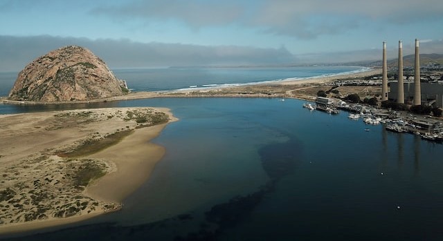 “The Chumash people viewed the Pacific Ocean as their first home. Their territory once spanned 7,000 sq miles, from the rolling hills of Paso Robles to the white sand beaches of Malibu. Now, the region is one of the most expensive in the US, home to resort hotels, vineyards and multimillion-dollar mansions. The average house price in Avila Beach, California, where Violet Sage Walker grew up hunting for grunion in the midnight hours, is $1.9m (£1.5m). “My father would walk across the creek on the backs of steelhead and salmon,” says Walker, the Chumash tribal chair. “They were that abundant. Now the water’s contaminated, from sewage, runoff and overpopulation. In one generation we’ve lost the ability to feed ourselves off the land.” As stewards of that land, however, the Chumash remain an active presence. … ” Read more from The Guardian.
Reservoir project for Cuyama vineyard falls through
“A proposal to develop more than 15 acres of new water reservoirs in the Cuyama Valley stirred division among local farmers and county officials at a recent public hearing. During the Santa Barbara County Planning Commission’s May 10 meeting, county staff presented findings to deny the project, which would include the construction of three frost ponds at North Fork Ranch to store water for its vineyards. The ranch is located within the Cuyama Valley groundwater basin, an area listed as “critically overdrafted” by the California Department of Water Resources. Staff determined that the site is unfit to accommodate the proposed frost ponds partly due to the overdraft conditions documented in the area. … ” Read more from the Santa Maria Sun.
Montecito Groundwater Sustainability Agency to consider adopting management plan
“The Montecito Water District and private well owners rely on the groundwater basin for water supplies, and for the past five years, the Groundwater Sustainability Agency has been working on a long-term management plan. The GSA board members, who are also on the water district board, will meet Friday to consider adopting the Groundwater Sustainability Plan and submitting it to the California Department of Water Resources. … “Groundwater is an important local source of water that is heavily relied upon by our entire community, particularly during drought. To that end, our sustainability goal is to prevent undesirable results and optimize long-term use of the groundwater basin for the benefit of all stakeholders,” GSA board president Brian Goebel wrote in the forward for the draft plan. … ” Read more from the Noozhawk.
SAN JOAQUIN VALLEY
Kern County makes river flood maps available to the public
“The Kern River is rising fast and, so far, the public hasn’t been given very good information on the one question on everyone’s mind: Where’s it going to flood? Wednesday, the Kern County Office of Emergency Services put out detailed, locally built maps that attempt to answer that question under various flow scenarios. The upshot is there is no current emergency but people with property and animals in low lying areas from Hart Park to the Manor Street area should prepare as much as possible with sandbags and other measures and be ready to leave if necessary, according to responder agencies. “We want to be very transparent and we want to provide information so the community can be prepared,” said Kern County Fire Chief Aaron Duncan during a press conference Wednesday where the maps were unveiled. … ” Read more from SJV Water.
EASTERN SIERRA
Wild horses further impact South Tufa at Mono Lake
“Last winter wild horses overwintered along the south shore of Mono Lake throughout South Tufa and Navy Beach. Record winter snow and poconip fog dramatically reduced public access and between 30 and 200 horses lingered in the area until spring. The impact was significant. Nearly every square meter of trail at South Tufa and Navy Beach was covered in manure, and manure piles blocked handicap access along the boardwalk from the parking lot to the lake. Several horses died at South Tufa over the winter and their scavenged carcasses were draped between tufa towers and along the lakeshore. Volunteer clean-up crews, including Mono Lake Volunteers, Inyo National Forest staff, and Mono Lake Committee staff have worked over multiple days to remove most of the manure from the trails and shoreline to preserve access and maintain some quality of visitor experience. … ” Read more from the Mono Lake Committee.
SEE ALSO: ‘Macabre’: Wild horses are mysteriously turning up dead at Mono Lake, from the San Francisco Chronicle
Eastern Sierra’s record-breaking rain and snow pack: the “gift” that keeps on giving
“Inyo County Supervisors got an update on efforts to deal with an anticipated run-off as epic as this past winter’s snowfall. Working with the Los Angeles Department of Water and Power, County road crews are working on repairing damaged roads and river undercuts. But, one ugly reality reared its head after staff outlined infrastructure hardening efforts: mosquitos. Inyo/Mono Ag Commissioner Nate Reade delivered the dire warning. With the Owens Valley serving as the river’s flood plain anticipated to be underwater through the summer, mosquitos will be drawn to the standing water bringing with them the threat of West Nile Virus. In other words, the Owens Valley may see a repeat of the summer of 2017 scenario. Reade doesn’t anticipate a real health issue until later this summer. His plan is to launch a public awareness campaign closer in time to the anticipated public health issue so locals won’t go “tone deaf” to the dangers. Plans include a larvicide drop early to mid-June, primarily close to population centers. … ” Continue reading from the Sierra Wave.
Ridgecrest: Details about LADWP water release at the Groundwater Authority meeting
“The Los Angeles Department of Water and Power is releasing water due to excessively high precipitation last winter, and five points of the release are flowing into the Indian Wells Valley. Since the releases started on March 29, they’ve already released over half the amount of water that usually flows into the local groundwater basin usually in a year. Jean Moran, senior hydrogeologist for Stetson Engineers, presented information on the release for the Indian Wells Valley Groundwater Authority at their regular board meeting on May 10. Her presentation showed the locations of the releases and the average rates of water being released from each. … ” Read more from the Ridgecrest Independent.
SOUTHERN CALIFORNIA
Environmental group victorious in legal challenge to Ballona Wetlands Project
“A judge Wednesday ruled in favor of an environmental group whose members alleged the state’s approval of a state restoration project for the Ballona Wetlands Ecological Reserve near Los Angeles International Airport failed to properly protect wildlife species. Los Angeles Superior Court Judge James C. Chalfant’s 67-page opinion in favor of Protect Ballona Wetlands also stated that engineers’ designs for excavating and bulldozing more than two million cubic yards of soil and removing levees did not use the correct flood risk standards. … ” Read more from My News LA.
Long Beach Utilities Commission to weigh plan that could stiffen penalties for water wasters
“The Long Beach Utilities Department is looking to update its water shortage contingency plan, which outlines what activities are prohibited during different stages of drought—and a new proposal could lead to steep fines for water wasters in the future. After an exceptionally wet winter, most of the state, including Long Beach, is out of drought-like conditions. With water agencies projected to get 100% of their requested water supplies from the state, many are looking to rescind some restrictions. … The Utilities Commission is expected to revise its shortage stage in June. … ” Read more from the Long Beach Post.
As high tides hit Southern California, NWS advises of regional beach hazards
“A Southern California beach hazard statement issued by the National Weather Service on Wednesday afternoon was extended to Orange County beaches until Thursday evening amid high surf and minor flooding. Waves were expected to be 4-7 feet and reach up to 8 feet at Orange County beaches, according to the NWS, which warned of dangerous swimming and surfing conditions. Minor flooding was expected due to the high tide; by Wednesday evening, some flooding had popped up near the Seal Beach Pier. On social media, the Seal Beach Police Department on Wednesday night said there was a high tide advisory in Old Town between 10th Street and 12th Street. Public Works and lifeguard crews were aware of the situation, police said. … ” Read more from the LA Daily News.
IMPERIAL/COACHELLA VALLEYS
1M Californians are in the dark about potential steep water rate hikes. Are you one?
“Diana Juarez’ granddaughters, 9 and 11, want her to buy them a kiddie pool to splash in on triple-digit days in Niland, a tiny town tucked in California’s blisteringly hot southeastern corner. No way, she tells them firmly. With summer water bills that can approach $200 a month, “that’s just water down the drain. We can’t afford that.” Juarez and her neighbors soon could face even higher bills. Once again, Golden State Water Company, the investor-owned utility that serves her and more than 1 million customers in 80 communities across California, has asked for rate increases. And once again, the California Public Utilities Commission is poised to approve a legal agreement that would raise rates, this time by nearly 14% for her community through 2024, and on average by 15% across the company’s service area, from parts of Sacramento and Simi Valley to Los Angeles and Orange County suburbs, and desert communities like Lucerne and Apple Valley. … ” Read more from the Desert Sun.
SAN DIEGO
Loveland Reservoir may be weeks away from partial reopening
“A group of East County residents made the trip to the South Bay Wednesday evening to fight for the reopening of Loveland Reservoir. It’s a topic they’ve been raising concern about for several months now. “We’re working with our insurance to make sure there’s no liability for the agency, so we will be looking at reopening the trail probably in the next few weeks,” said Carlos Quintero, General Manager at Sweetwater Authority. Community members from Alpine and the surrounding area near the Loveland Reservoir finally got the first glimmer of hope as to when the reservoir might reopen. … ” Read more from Channel 5.
Along the Colorado River …
Western states and feds are closing in on a landmark deal to prevent Lake Mead from plummeting further
 “Three Western states and the federal government are nearing a deal to leave millions of gallons of water in the Colorado River’s Lake Mead – water that would have otherwise been used to irrigate fields or generate hydropower – in exchange for at least $1 billion in federal funding for voluntary water cuts, according to two sources familiar with the plan. The Colorado River system provides water and electricity to more than 40 million people in seven states, as well as irrigation for Western farmers. But that system has shown alarming water loss after a multi-year, climate change-fueled drought collided with decades of overuse. Western states and the federal government have been in tense discussions for months to come up with a plan to prevent the Colorado River and the nation’s largest reservoirs, Lakes Mead and Powell, from teetering into disaster. … ” Read more from CNN.
SEE ALSO: A Solution to the Colorado River Crisis Could Be In Sight, from Esquire
Lake Mead water level rise steady as Lake Powell surges
“Over the last three weeks Lake Mead’s water level has risen 4.6 feet thanks mainly to extra water being released from Lake Powell beginning on April 24. On the morning of May 17, Lake Mead’s water level appeared to level off but its rise is expected to continue through at least the end of May. In fact, Lake Mead has actually risen 11.05 feet since hitting a low mark of 1,040.71 feet above sea level on July 27, 2022. Currently, Lake Mead’s water level is at 1,051.76 feet. Since the beginning of May, Lake Mead has been rising approximately three inches a day, which is great news for people who make a living at the lake and for anyone who boats, fishes, or swims there. However, three inches a day is nothing compared to how fast Lake Powell’s water level is rising. … ” Read more from KLAS.
Restrictions, emerging contaminants add to challenges of AZ water treatment
“Monitoring, testing and cleaning up Arizona drinking water is a gargantuan task. The Arizona Department of Environmental Quality (ADEQ) regulates 1,500 water systems across the state, from something as large as the Phoenix municipal network to something as small as a Mohave County gas station. “Our responsibility is to make sure that those water systems are regularly sampling for water contaminants,” said Trevor Baggiore, director of ADEQ’s Water Quality Division. That division helps ensure public water systems meet EPA Safe Drinking Water standards for around 90 microbes, chemicals and radiological particles. But the EPA cannot set standards until the research is in — if then. “The science around emerging contaminants is continually evolving,” said Baggiore. So, could — or does — Arizona water treatment cope with emerging contaminants? … ” Read more from KJZZ.
Arizona’s farms are running out of water, forcing farmers to confront climate change
“Farmers across southern Arizona are among those in the West facing the brunt of climate change. The drought, worsening fire seasons, temperature swings and monsoons all impact their businesses, food production, utility costs and livelihoods. Rural communities also tend to lean Republican politically, which can put them at odds with climate activists and environmental protection groups, which tend to be more aligned with Democrats. And the agriculture sector accounts for an estimated 11% of U.S. greenhouse gas emissions, putting farmers directly in the crosshairs of climate advocates. But farmers in this region, across the political spectrum, say they also want solutions on climate issues now. … ” Read more from NPR.
Report: Arizona must deploy a diverse range of strategies to solve water crisis
“Arizona’s water crisis is getting worse, and on Wednesday, environmental groups warned that there’s no “silver-bullet” solution that can fix it. In a new report by the Water for Arizona Coalition, analysts urge the state to embrace a diverse range of water conservation and management strategies — and to start investing in them fast. “It is imperative that the state make conscientious water investments to ensure long-term prosperity for Arizonans,” writes Rachel O’Connor, a climate resilient water systems manager with the Environmental Defense Fund, who partnered with the coalition on the report. … ” Continue reading at FERN’s Ag Insider.
Colorado’s above-average snowpack has an enemy: Out-of-state dust
“The story Susan Behery tells about dust blowing into Colorado from New Mexico and Arizona sounds almost Biblical, like cows dropping dead in their owners’ fields or swarms of locusts devouring their crops. A hydraulic engineer for the Bureau of Reclamation in Durango, Behery says she once saw dirt falling from the sky in the manner of rain. It was so heavy, she said, it splatted when it hit the ground. When the storm that brought it moved on, a brown residue covered Behery’s car, her lawn furniture, her house. In fact, it covered the town of Durango, the town of Silverton and the San Juan Mountains, where Behery’s colleague, Jeff Derry, does the bulk of his work as the executive director and lead scientist for the Center for Snow and Avalanche Studies and its Dust on Snow program. … ” Read more from the Colorado Sun.
In national water news today …
Judge panel orders EPA to regulate perchlorate-contaminated drinking water
“A three-judge panel has ruled unanimously that the U.S. EPA must reverse its recent decision not to regulate the presence of a notorious industrial contaminant in drinking water. “A federal appeals court rules … that the Environmental Protection Agency must regulate perchlorate, reversing a Trump-era rollback on a drinking water contaminant linked to brain damage in infants,” the Associated Press reported. “Circuit Judge Florence Pan … called the EPA’s decision not to regulate perchlorate ‘arbitrary’ and ‘capricious’ and rejected the agency’s assertion that perchlorate was occurring at lower levels than previously thought.” … ” Read more from Water Online.
Fitch Ratings: EPA’s cyber rules will add financial burden for utilities
“According to a release from credit rating firm Fitch Ratings, the U.S. Environmental Protection Agency’s (EPA) requirement that all public water systems incorporate cyber risk and resiliency in their periodic reviews will add an increased regulatory and financial burden that could be even greater for smaller systems and systems with minimal existing cyber infrastructure. Fitch Ratings says the requirement could have a significant effect on water utilities’ capex budgets, and margins would be pressured if systems are unable or unwilling to pass on the added costs to customers through rate increases. … ” Read more from Water Finance & Management.
The upper atmosphere is cooling, prompting new climate concerns
“There is a paradox at the heart of our changing climate. While the blanket of air close to the Earth’s surface is warming, most of the atmosphere above is becoming dramatically colder. The same gases that are warming the bottom few miles of air are cooling the much greater expanses above that stretch to the edge of space. This paradox has long been predicted by climate modelers, but only recently quantified in detail by satellite sensors. The new findings are providing a definitive confirmation on one important issue, but at the same time raising other questions. The good news for climate scientists is that the data on cooling aloft do more than confirm the accuracy of the models that identify surface warming as human-made. … ” Read more from Yale e360.
NASA near real-time SWE report …
20230515_RT_SWE_Report
