

On the calendar today …
- VIRTUAL PUBLIC MEETING: Colorado River Draft SEIS from 4:30pm to 7:00pm. Reclamation will hold four virtual public meetings to provide information on the draft SEIS, answer questions, and take verbal comment. This is the third of the four meetings. An interactive webpage with information on the project background and summaries of the draft SEIS alternatives and analyses will be posted on the project website prior to the virtual public meetings. Each virtual public meeting will begin with 30 minutes for participants to explore the background information on the webpage at their own pace. The formal meeting presentation will begin 30 minutes after the scheduled meeting start time. Reclamation will take questions and public comments following the presentation. The interactive webpage materials and the virtual public meetings will be available in Spanish. Click here to register.
In California water news today …
Will California’s ‘big melt’ cause catastrophic floods? Here are four scenarios.
“California’s “big melt” is underway, and if forecasts bear out, much of the water being held in mountain snow will flow downhill in May and June. But at the moment, the state’s snowpack remains huge — about three times its normal size for this time of year — and depending on coming conditions, the snow can either dissipate slowly or quickly cause trouble. Snowmelt often accelerates in May with warmer weather, longer days and a higher sun angle. “May is typically one of, if not the, month with the most melt,” said Andrew Schwartz, lead scientist at the University of California at Berkeley’s Central Sierra Snow Lab. “There is definitely going to be a whole lot of melt coming our way.” … With the weather driving how quickly snow will melt, here are four scenarios that could determine flood severity this spring and summer. … ” Read more from the Washington Post (gift article).
‘Astronomical’ western snow is now melting but not flowing where water managers need it
“Historic Western snow had so many who suffered through drought for years celebrating. But the snowpack, which acts as a frozen reservoir, is melting and not going exactly where water managers need it. “This is a classic water problem. We either have too much or too little and always at the wrong time,” Steven Fassnacht, professor of Snow Hydrology at Colorado State University, told FOX Weather. “For example, in California, some reservoirs are already full, and there’s not a lot of places we can put this excess water.” He points to Tulare Lake in California, which is reappearing after being gone for a century. … ” Read more from Fox Weather.
SEE ALSO: Striking satellite photos show the dramatic scale of California’s 2023 snowpack, from the LA Times
Experts signal cautious optimism amid mixed drought recovery in West
“While California’s water outlook saw marked improvement in the short term, climatologists say years of worsening conditions across the West will take far more than this winter’s storms to recuperate. Veva Deheza, executive director for the National Oceanic and Atmospheric Administration’s National Integrated Drought Information System, said in a briefing Tuesday that about 25% of the West remains in drought — compared to 74% at the start of the water year this past October. “However, we recognize that not all states received above-average precipitation,” Deheza said. “It will take more than one winter, albeit a very wet winter, to replenish the water in many areas as well as Lakes Powell and Mead — which are still at historic low levels.” … ” Read more from the Courthouse News Service.
SEE ALSO: Half of US West out of drought, but not fully recovered, from KTLA
Putting flood waters to work: State expedites efforts to maximize groundwater recharge
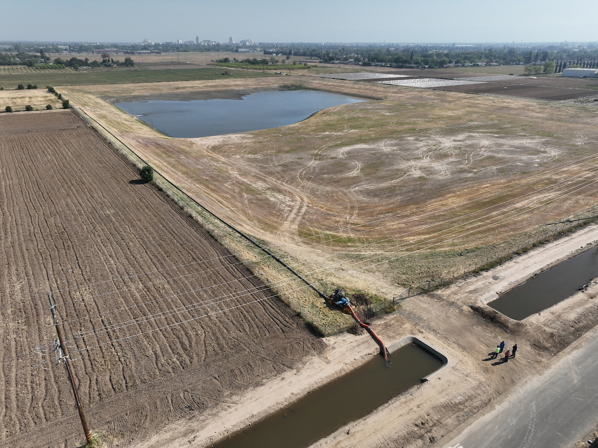 “The Department of Water Resources (DWR) is implementing an emergency program to divert high river flows away from flood-prone Central Valley communities and into groundwater recharge basins. DWR is working with local agencies and equipment vendors to provide funding and secure much-needed temporary diversion equipment, including pumps and siphons, and will support their deployment by local agencies. The first set of temporary pumps and siphons were deployed by Fresno Irrigation District on April 25, as seen in this video. The district is reducing downstream flood impacts in the Tulare Lake Region and expanding groundwater recharge efforts by diverting water from Kings River reaches to existing recharge facilities or working agricultural lands. … ” Read more from DWR.
The science behind atmospheric rivers
“Atmospheric rivers occur in the Earth’s atmosphere as a concentrated band of moisture and wind that transports large amounts of water vapour and are the largest and most important transport mechanisms of freshwater on Earth. Similar to terrestrial rivers, atmospheric rivers can vary in strength and size and can occur both in the Northern hemisphere – typically between December and February – and in the Southern hemisphere – typically between June and August, when extratropical cyclones are prevalent. In order for atmospheric rivers to form, the following conditions are required … ” Read more from Earth.org.
New study to examine ag regulations
“A new study announced by the California Department of Food and Agriculture will evaluate agriculture’s food safety and water quality regulatory reporting requirements as part of an effort to streamline administrative processes and optimize information collected by the state. The study is supported by funding in the 2021-22 budget. CDFA is contracting with Sacramento-based Crowe LLC to conduct the study. Crowe will map current CDFA and State Water Resources Control Board ag-related food safety and water quality reporting requirements. The results of the study will support the State’s protective food safety and water quality standards while advancing efficient reporting practices and opportunities to create synergistic partnerships between agencies on information collected. … ” Read more from Farm Progress.
Wet year allows more rice to be planted
“Thanks to a wet winter and spring, California rice country is humming with activity again, with planes dropping seed on flooded fields and equipment working the ground as planting ramps up in the Sacramento Valley. It’s a scene that Colusa County grower Bruce Rolen says he views with elation, considering he planted not one grain of rice a year ago. At the height of the state’s multiyear drought, reduced water deliveries to farms last season left “fallow fields that were just growing tumbleweeds and thistle plants,” he said. Plentiful rainfall, an enormous snowpack and brimming reservoirs have changed all that, with farmers “just tickled” that they will have enough water to plant their full acreage. … ” Read more from Ag Alert.
Almond acreage drops but rains, trade boost hopes
“Citing California’s improved water supply and increased almond shipments in early 2023, growers and almond sector leaders say the outlook has improved for the state’s No. 3 crop, valued at $5 billion. Three years of drought and a drop in the almond price prompted growers to remove orchards and plant fewer trees. However, conditions changed this winter after atmospheric river storms brought above-average snowpack and filled empty reservoirs. “We were on pins and needles that this was going to be another drought year, but our fortune changed quite dramatically with the winter that we had,” said Richard Waycott, president and CEO of the Almond Board of California. … ” Read more from Ag Alert.
As California attempts a ‘managed retreat,’ coastal homeowners sue to stay
“Mirada Road is a small cul-de-sac that runs right up to the edge of the Pacific Ocean, skirting the rim of a 30-foot bluff. Back in 2016, a storm sent huge waves crashing against the shoreline, destroying most of the bluff overnight and leaving the Mirada Road homes in danger of immediate collapse. The homeowners association rushed to build a rock wall that would protect their homes. The legal battle that followed was even more turbulent than the storm. … The fracas over Mirada Road is just the latest in a series of legal disputes over “managed retreat,” a controversial climate adaptation policy that calls for relocating and removing coastal structures rather than protecting them where they are. Experts say managed retreat is an important last-resort option for adapting to climate change, but California’s early attempts to implement the policy have provoked a backlash from homeowners and politicians. … ” Read the full story at Grist.
Fire retardant kills fish. Is it worth the risk?
“On a hot, dry August day in 2002, air tankers swooped over a small wildfire south of Bend, Oregon. The Forest Service hoped to suppress the flames by dropping over a thousand pounds of fire retardant on and around the fire — but the pilots missed. Instead, the neon-red liquid cascaded into the nearby Fall River, a tributary of the Deschutes. Soon after, at least 22,000 trout died — virtually all the fish living in a six-mile stretch. Retardant contains ammonium phosphate, which is highly toxic to fish and other aquatic life. In the years following the accident, Forest Service Employees for Environmental Ethics (FSEEE), a Eugene, Oregon-based nonprofit that represents former and current Forest Service employees, has called for policy changes regarding the use of retardant. The group has won two lawsuits against the Forest Service restricting its use and is now suing the agency over employing it in and around streams and creeks. The suit has reignited debates over retardant’s firefighting efficacy, and the outcome could change how it is used in the future. … ” Read more from High Country News.
The linked ecological futures of America and China
” … The cause — and perhaps solution — of the multi-decade megadrought stifling the American Southwest on a scale not seen in more than a millennium is tied in surprising ways to another desert, one on the other side of the world. Seven thousand miles away, in the Taklamakan Desert, dust is blown into the jet stream that links western China to the Western United States. This Asian dust, scientists have found, contributes to rainfall in America, a reminder of the planetary equilibrium the two countries are intimately enmeshed in. In this precarious symbiosis, discoveries by both nations in understanding and mitigating the plight of drought may forge a powerful bridge across divided deserts. …” Read more from Noema.
Delta Conveyance Project …
Report: How the Delta Conveyance Project could bankrupt the Metropolitan Water District

Max Gomberg, formerly with the State Water Board and now an independent consultant working with California-based and national advocates on water affordability and climate equity, writes, “This assessment has been prepared for the California Water Impact Network (C-WIN), a statewide non-profit organization dedicated to the equitable and sustainable distribution of water in California. Its purpose is to present an assessment of risks and potential impacts from the Metropolitan Water District’s (MWD or Metropolitan) continued pursuit of new water delivery infrastructure from the Sacramento-San Joaquin Delta (Delta). … It is my sincere hope that MWD and other policymakers seriously grapple with the issues raised in this assessment, regardless of their views on C-WIN’s advocacy. California’s climate is changing rapidly, and its disadvantaged communities are bearing the brunt of the impacts. We need new approaches to water management that are rooted in equity and elevate ecological resilience and affordability over unconstrained agricultural production and lush urban landscapes. There is no such thing as an economically and environmentally responsible “all of the above” strategy. We face tough choices and a need for leaders willing to make them. … ” Read the full press release and access the report at C-WIN.
Report urges Metropolitan Water District to abandon Newsom’s $16-billion delta tunnel plan
“Gov. Gavin Newsom and his administration have touted plans to build a tunnel to transport water beneath the Sacramento-San Joaquin River Delta, saying the project would modernize California’s water infrastructure and help the state adapt to climate change. But an advocacy group is urging the Metropolitan Water District of Southern California to abandon the $16-billion project, saying it doesn’t make financial sense for the state’s largest urban water agency. In a report released this week, the California Water Impact Network said the delta tunnel may seem like a viable alternative but has three major flaws: “an exorbitant price tag, environmental restrictions on operations and the impacts of climate change on deliveries.” “This is a critical decision point,” said Max Gomberg, a former State Water Resources Control Board staffer who wrote the report and has criticized the Newsom administration. … ” Read more from the LA Times. | Read via Yahoo News.
Statewide poll shows 76% of voters support the Delta Conveyance Project to modernize CA’s main water distribution infrastructure
“Today, Californians for Water Security released results of a recent statewide poll showing that voters across all regions, political parties and major demographics are highly supportive of the Governor’s Delta Conveyance Project. Seventy-six percent (76%) of voters say they support the Delta Conveyance Project when read a description, including 40% of voters that strongly favor the project. Only 13% of voters oppose the project. And voters across party and region also strongly support the project, with 81% of Democrats, 65% of Republicans and 76% of No Party Preference voters expressing support. “Californians are saying loud and clear: it’s time to move forward with the Delta Conveyance Project to improve the reliability of our state’s water supply,” said Jennifer Pierre, General Manager of the State Water Contractors. … ”
In commentary today …
California holds the key to Western water security
Edward Ring, contributing editor and senior fellow with the California Policy Center, writes, “Dams and aqueducts on the Colorado River make civilization possible in the American Southwest. But for the last 20 years, as a prolonged drought has gripped the region, withdrawals from the river have averaged 15 million acre-feet per year, while inflows into Lake Mead and Lake Powell have averaged only 12 million acre feet per year. … Despite months of negotiation, the seven states that draw water from the Colorado River have failed to come to an agreement on how to adapt to its dwindling flow. The current deadlock pits California against the other six states – Wyoming, Colorado, Utah, New Mexico, Nevada, and Arizona. But if they had the political will, California could solve the whole problem for everyone. … ” Read more from the California Globe.
Today’s featured article …
FEATURE: Ecosystem Restoration Progress Review for the Delta and Suisun Marsh

The Delta and Suisun Marsh are among the most important ecosystems in the state, providing vital habitat for a variety of plant and animal species, supporting numerous recreational activities, and supplying drinking water for millions of people. However, the Delta’s ecosystem and native species have been declining for decades, with loss of habitat among the numerous factors. In recent years, significant efforts have been made to restore habitat. At the 2023 Interagency Ecological Program Annual Meeting, Daniel Constable, environmental program manager with the Delta Stewardship Council, reviewed the restoration progress made in the Delta and Suisun Marsh.
In regional water news and commentary today …
NORTH COAST
Snowfall in Klamath National Forest above average
“The Klamath National Forest has completed the May 1 snow surveys. These measurements are a part of the statewide California Cooperative Snow Survey program, which helps the state forecast the quantity of water available for agriculture, power generation, recreation, and stream flow releases later in the year. Spring has arrived, along with warmer temperatures. Despite elevated temperatures, including unseasonable highs during the last week of April, the snow pack continues to persist in the high country even as it melts from the lower slopes. According to measurements taken for the May survey, the snowpack is at 170% of the long-term average snow height (snow depth) and at 159% of the long-term Snow Water Equivalent across all survey points. … ” Read more from Herald & News.
Clear Lake tule has rich history
“The aquatic plant in Clear Lake that has been around the longest is without question the tule. That plant has been part of Clear Lake for at least several thousand years and is the most common aquatic plant on the lake. The tule is easily recognized. It’s a tall plant ranging in height from 3-6 feet. The stem is round, green in color and topped with brown seed clusters. The tule is almost always found standing in water. They are located around the lake and are a native plant. Tules die during the winter months and come back in the spring and early summer months. They are a hardy plant and can withstand drought as well as flooding. The lake’s shoreline was originally covered with tules stretching out into the lake for up to hundreds of yards. … ” Read more from the Lake Record Bee.
MOUNTAIN COUNTIES
A photographic journey of snow melt across the Truckee River
“Even while the recent heatwave is over and warming temperatures are ahead, the central Sierra snowpack remains at nearly 300% of normal, with much of the Truckee River watershed at 200%. The heatwave brought regional-wide record temperatures which accelerated melting of the snowpack, raising the river and enacting a flood watch. This also had officials warning the public to avoid swimming in the river as it is running cold and fast. With more snowpack melting soon, we wanted to take a chance to see what rising water across the Truckee River looks like, and see what those images can tell us about the river’s health, ecology and development. … ” Read more from the Sierra Nevada Ally.
SACRAMENTO VALLEY
Lake Shasta, rivers filling. Why boaters and swimmers should beware
“As the weather warms and people venture onto North State lakes and waterways, law enforcement and park officials in Shasta and Siskiyou counties are warning of fast-moving, frigid water that sweeps along logs, branches and other dangerous debris. They’re asking swimmers, boaters and kayakers to check conditions before taking the plunge. Noting “warmer temperatures finally hitting our area and a nearly full Shasta Lake,” the Shasta County Sheriff’s Boating Safety Unit recently issued an announcement letting the public know that hazards also exist. Those include sections of the lake where the water remains extremely cold, even if the air is warm. “Even experienced swimmers can lose muscle control quickly in cold water,” officials said. … ” Read more from the Redding Record Searchlight.
Butte County Supervisors hear 2022 groundwater report
 “Last year didn’t do any favors for the California drought. In the winter months from January onward in 2022, Butte County, along with other Northern California regions, saw little to no rain — and what bit of winter weather it did see came in the form of a freeze during the almond bloom. In addition to consistent drought conditions, local groundwater suffered significantly. On Tuesday, members of the Butte County Department of Water and Resource Conservation provided a presentation before the Board of Supervisors on the year in terms of groundwater as well as an update on where the county is so far in 2023, which has been considerably wetter. Water Resources Scientist Kelly Peterson led the presentation alongside department Director Kamie Loeser and Assistant Director Christina Buck, who’s also a water scientist. … ” Read more from the Chico Enterprise-Record.
City of Vacaville, Solano County Water Agency partner for rebate program
“Thanks to a partnership between the City of Vacaville and the Solano County Water Agency (SCWA), there are several water conservation rebates and programs available to qualifying residents. As part of the City Council District 5 Benefit Program, Vacaville residents are now eligible for a rebate of $2 per square foot for a maximum of 1,000 square feet, or $2,000, for replacing their existing turf with water efficient landscaping. This rebate has been raised from its previous rate of $1.50 per square foot. The $2 rebate applies to applications dated May 5, 2023 or later and may not be applied retroactively. Turf replacement rebates are subject to available funding. A pre-inspection prior to removal of existing turf is required and replacement of turf with artificial grass and/or concrete is not eligible. … ” Read more from the City of Vacaville.
BAY AREA
Stinson Beach to begin study of sea-level rise defenses
 “As sea level rise threatens to inundate hundreds of homes, cut off roads and swallow the sands of Stinson Beach, Marin planners and town residents are preparing a new defense plan in an effort to save the popular coastal destination. Bordered by both the Pacific Ocean and Bolinas Lagoon, the town of about 500 residents is in the vanguard of Marin communities most vulnerable to rising ocean waters. Residents such as Jeff Loomans, who has owned a home in the town for 13 years, said the future their community faces is driven home by recent incidents such as the January winter storms that battered homes, broke pilings, flooded roads and washed away tons of sand. “I would say sea level rise is already here. It’s not something that is just coming,” said Loomans, who also serves on the Stinson Beach Village Association’s sea level rise committee. … ” Read more from the Marin Independent Journal.
Work begins to refill Shadow Cliffs Lake
“For the first time since 2020, the lake at Pleasanton’s Shadow Cliffs Regional Recreation Area could soon have enough water for people to swim, fish and drive their boats if all continues to go well with recent water-pumping efforts. The water refill project, which is currently using two diesel-powered water pumps to move water from the Arroyo Del Valle water stream into Shadow Cliffs Lake, came together after the recent winter storms basically ended the year-long drought that plagued lakes and water supplies across California. “The past several years of drought have left the Shadow Cliffs Regional Recreational Area water level much lower than our community is used to, and we anticipate residents will be happy to see the water level higher this summer,” Heather Tiernan, communications manager for the city of Pleasanton, told the Weekly. … ” Read more from Pleasanton Weekly.
Valley Water inspects pipeline that moves water into Santa Clara County
“In March 2023, Valley Water completed the first phase of a shutdown and inspection of a large section of pipeline that delivers water from San Luis Reservoir into Santa Clara County. The pipeline, known as the Santa Clara Conduit, runs for about 22 miles from San Luis Reservoir off Highway 152 to the Coyote Pumping Plant in Morgan Hill. The pipeline, built in 1982 by the U.S. Bureau of Reclamation, is operated and maintained by Valley Water. Last winter, the Santa Clara Conduit was shut down for about five months. Work crews inspected approximately 10 miles of the pipeline (from Casa De Fruta to Leavesley Road in Gilroy) and installed state-of-the-art monitoring equipment to better monitor the infrastructure’s condition in the future. … ” Read more from Valley Water News.
More grant money means expanded fire mitigation in Los Gatos Creek Watershed
“The Los Gatos Creek Watershed Collaborative received one of the largest awards last week in CAL FIRE’s latest round of Forest Health Grants. The $6.3 million grant will go toward expanding the collaborative’s project area by 841 acres to include Aldercroft Heights and Lupin Lodge, residential neighborhoods in the Santa Cruz Mountains, bringing overall coverage to 2,700 acres. Aldercroft Heights and Lupin Lodge have a handful of areas that are at a high fire risk. Residents have to travel one-lane roads during evacuations, which can cause traffic and congestion, said Seth Schalet, chief executive officer of the Saratoga-based Santa Clara County FireSafe Council. The watershed is located in the Santa Cruz Mountains that border Saratoga, Los Gatos and San Jose, near where the CZU Lightning Complex Fire burned 86,509 acres in Santa Cruz and San Mateo counties in 2020. It also holds water reservoirs that serve more than 100,000 people. … ” Read more from the San Jose Mercury News.
CENTRAL COAST
Commentary: Farmers seek solutions for flood-control failures
Norm Groot, executive director of the Monterey County Farm Bureau, writes, “The destruction to agricultural properties and crops from January and March flooding in Monterey County is considerable. There is frustration about a failure to address known dangers that caused or worsened the flood toll in this critical farming region. For decades, the Salinas River channel has been clogged with excessive vegetation, much of it non-native Arundo donax, a bamboo-like reed that grows to over 30 feet at maturity and creates vegetative dams. Significant sediment buildup also decreased the flow capacity of the river during heavy storms, such as the atmospheric rivers this winter. Fortunately, in January, our reservoirs were nearly empty and could capture much of the flood capacity before it contributed to river drainage flows. That was not the case in March when reservoirs were forced to release water to increase storage space for incoming water. … ” Continue reading from Ag Alert.
SAN JOAQUIN VALLEY
Fresno Irrigation District diverts Kings River floodwater into aquifer
“With many residents on high alert for flooding from the Sierra snowmelt, the state Department of Water Resources has begun an effort to divert high river flows from flood-prone Central Valley communities and into groundwater recharge basins. DWR is working with local agencies and equipment vendors to provide funding and secure much-needed temporary diversion equipment, including pumps and siphons, in support of local agencies. The first temporary pumps and siphons were deployed by the Fresno Irrigation District on April 25. The district is reducing downstream flood impacts in the Tulare Lake region and expanding groundwater recharge by diverting water from Kings River reaches to existing recharge facilities and farmland. … ” Read more from GV Wire.
Concerns for large mosquito population this summer in Central California
“Mosquito bites can be irritating, but they can also carry diseases. That’s why Kings County leaders want the public’s help in reducing the number of mosquitoes seen this summer. A wet spring and winter, flooding caused by snowmelt, and plenty of standing water are creating the perfect breeding conditions for mosquitoes. “It’s kind of unprecedented level of probably mosquito production, we’re gonna see this year with all the water,” said Michael Cavanagh, District Manager of Kings Mosquito Abatement District. “So there’s a natural link, I think, to potential disease transmission, West Nile virus and some of the other diseases that mosquitoes carry.” … ” Read more from KFSN.
Officials identify local infrastructure at risk of flooding in Bakersfield
“Senior Kern County officials assessing flood risks to critical local infrastructure have identified Bakersfield Heart Hospital as potentially vulnerable to inundation in the weeks ahead, followed to a lesser degree by Mercy Southwest and the former Big West refinery on Rosedale Highway. In case either medical center does flood, a plan has been put in place for other local hospitals to take in patients who might have to be evacuated, said the county’s director of emergency services, Aaron Duncan, who emphasized he was not saying the area around Bakersfield Heart will flood. “I’m saying we need to be prepared,” Duncan said, adding, “Right now, there’s no risk to any hospitals.” … ” Read more from SJV Water.
Army Corps prepares for large-volume snowmelt at Isabella Lake
“Due to record-high snowpack over the winter, the USACE Sacramento District is preparing for above-average inflows to and outflows from USACE-managed reservoirs throughout California’s Central Valley, including Isabella Lake. The district expects Isabella Lake to exceed gross pool of 568,000 acre-feet this summer, which will cause the dam’s service spillway to release water for the first time since 1983. Based on the rate and timing of snowmelt, this spill could last several weeks, beginning sometime between late May and mid-June. There is no expectation that water levels will reach the top of the new labyrinth weir or spill into the emergency spillway. The emergency spillway is designed to be used in a 4,000-year flood situation, meaning that in any given year there is a 1 in 4,000 chance of such an event. Current snowmelt projections are far below this level and are not expected to get there. … ” Read more from the Army Corps of Engineers.
SOUTHERN CALIFORNIA
Candidates sought to fill vacant AVEK board seat
“The Antelope Valley-East Kern Water Agency is seeking a board member for the Division 1 seat. The agency is seeking candidates to fill the unexpired term for Director Shelley Sorsabal until the November 2024 elections. Candidates must reside within the AVEK Division 1 boundaries, which run south of the Kern County line from Frazier Park in the west to the San Bernardino County line in the east. The division’s southern boundary is roughly Avenue J in the east and the foothills west of Palmdale in the west, with carve-outs around the cities of Lancaster and Palmdale. … ” Read more from the Antelope Valley Press.
State agency fails to protect San Gabriel Valley from Quemetco’s contamination
“California’s environmental regulatory system and its systemic failures has been increasingly questioned by residents of the East San Gabriel Valley community in Los Angeles. The struggle for a safe environment is exacerbated by Quemetco’s chronic toxic contamination from the byproducts of lead-smelting and the failure of state agencies like the Department of Toxic Substance Control to protect communities from toxic exposure. This is further evidenced in the fractured renewal process enabled by DTSC allowing Quemetco to continue its ongoing pollution. In a meeting in early February, 200 community members attended a Settlement Agreement Workshop hosted by DTSC. The community demanded answers to DTSC’s failure to regulate Quemetco’s egregious violations, such as the containment leak in the building used to store hazardous waste and the failed implementation of a proper groundwater monitoring network for nearly two decades. The San Gabriel aquifer, a source of drinking water for 1.2 million SGV residents, faces a risk of further contamination due to DTSC failing to fulfill its job. … ” Read more from Liberation.
Joint venture inked for ‘landmark’ Southern California water reuse program
“A joint venture of AECOM and Brown and Caldwell (AECOM-BC Team) has been chosen to provide program and project management support and engineering design services for the Pure Water Southern California program, one of the largest water reuse programs in the world. The innovative program, being developed by the Metropolitan Water District of Southern California (Metropolitan) in partnership with the Los Angeles County Sanitation Districts (Sanitation Districts), will produce up to 150 million gallons of high-quality, purified water per day for up to 15 million people. Anticipated for water delivery by 2032 and potentially earlier, the program will reuse the largest untapped wastewater source in the region that currently flows to the ocean to increase water resiliency, enhance water quality, and fuel economic growth. It will lower Southern California’s reliance on imported water supplies from the Colorado River and Sierra Nevada and replenish groundwater basins while leveraging cutting-edge research and development to increase regional water reuse. … ” Read more from Water Finance & Management.
Long Beach moves to hold water polluters accountable
“Long Beach will begin work on identifying the responsible parties for recent sewage spills into the city’s coastal areas — and determining whether the city can seek any cost reimbursement for damages caused by the pollution — after the City Council OK’d an item requesting city staff look in to the problem on Tuesday, May 9. The unanimously-approved item, which was brought forward by Third District Representative Kristina Duggan and co-signed by Vice Mayor Cindy Allen and First District Representative Mary Zendejas, also requested the Climate, Environment, and Costal Protection Committee to prepare a report outlining the environmental, public health, social, and economic impacts of sewage spills in the city. Over the past 15 years, more than 42 million gallons of sewage entered Los Angeles County waterways — the vast majority of which was released by the nearly catastrophic disaster at the Hyperion Water Reclamation Plant and the sudden collapse of a sewer system in Carson in 2021 — according to data obtained by the county Public Health Department data dating back to 2007. … ” Read more from the Long Beach Press Telegram.
In Southern California, everything is blooming everywhere all at once
“There is always something growing inside the gated courtyard of the L.A. Catholic Worker Hospitality Kitchen, the Skid Row food distribution center better known as the “Hippie Kitchen.” But this spring has super-charged the courtyard’s trees and lush greenery, which offer shade and sanctuary to the hundreds of neighborhood residents who come for the kitchen’s thrice-weekly meals. “This plant here — I’ve never seen so many flowers on it,” marveled organizer Matt Harper, pointing to the berry-like blooms on a natal lily. Magenta explosions of bougainvillea frothed over the kitchen’s gates and the cinder-block walls of the vacant lot next door. The Indian coral tree’s fire-colored blossoms popped against green leaves. There was even a calla lily blooming from a patch of dirt everyone at the kitchen thought had gone barren. … ” Read more from the LA Times.
USACE, San Clemente enter 50-year shoreline protection agreement
“The U.S. Army Corps of Engineers (USACE) Los Angeles District has signed a ceremonial project partnership agreement to protect the San Clemente, California shoreline, combatting coastal erosion with an extensive beach nourishment project. The press conference and ceremonial signing celebrates the collaboration between USACE and the City of San Clemente. The collaboration is for a 50-foot-wide beach nourishment project along a 3,412-foot-long stretch of shoreline using a replenishment of 200,000 cubic yards of compatible sediment every six years on average for the next 50 years. The initial construction is an estimated $15 million with a 65/35 cost share between the Corps and the City of San Clemente. … ” Read more from Stormwater Solutions.
Along the Colorado River …
Colorado River reservoirs buoyed by snowmelt, but officials brace for drier times ahead
“This year’s unusually deep Rocky Mountain snowpack is now expected to lift both Lake Mead and Lake Powell from critically low water storage levels and leave them about one-third full, federal and state officials said Friday at a joint Colorado River briefing in Phoenix. It means the Southwest’s shortage won’t worsen in the coming year, and that Lake Powell will be able to repay a debt to Lake Mead, the larger reservoir downstream, incurred last year when the government held back water to protect hydropower generating capacity at Glen Canyon Dam. At least until snow starts flying again this fall, that’s where the good news begins and ends. The river remains in crisis, and recent history during a 23-year megadrought suggests scarcity may reassert itself in the coming year. … ” Read more from the Spectrum.
Indigenous tribes were pushed away from the Colorado River. A new generation is fighting to save it.
“A pivotal place in the history of the Colorado River is down a narrow desert road in Northern Arizona. To get there, you have to drive through towering canyons of rust-colored rocks, and past herds of bighorn sheep. When the road finally reaches a parking lot near the river’s edge, you’ll see a wide expanse of clear water, some dilapidated stone buildings and people applying sunscreen. This is Lee’s Ferry, a popular spot downstream from Lake Powell where people launch their boats for a journey through the Grand Canyon. But the spot hasn’t always been a recreational destination. Indigenous people first used this place as an important river crossing. Then it was settled by Latter-Day Saints, who were some of the first white colonizers in this area. The group saw it as their mission to spread across the southwest, establishing farmland and communities and evangelizing their religion. They set up this spot as a river ferry, with a man named John Lee as the ferryman who moved people, supplies, livestock and anything else they needed across the water. … ” Continue reading at Colorado Public Radio.
Commentary: Bottom line is, we all face using a lot less water from the Colorado River
Ken Neubecker, worked for American Rivers for nearly 10 years and now owner of Western Rivers LLC, writes, “This winter has been a record breaker. The Upper Basin snowpack is at an all-time high and the runoff in our rivers is expected to be similar. While the Drought Monitor shows nearly all of Colorado being drought free, we are by no means out of the woods. Make no mistake, we are still in the grips of the megadrought, or aridification, that began 23 years ago. This year’s runoff will help put a bit of water back into Lakes Mead and Powell, but they are still at record lows and it will take far more than one winter’s snowpack to bring them back. The Federal government, through the Department of Interior, issued an ultimatum to the seven Colorado River Basin states to find water and help these reservoirs through conservation, to the tune of 2 to 4 million acre feet. That’s a lot of water. … ” Read more from the Glenwood Post Independent.
‘Water cops’: How Las Vegas slashed water use with dawn patrols and lawn bans
“Leaky hose pipe? Watch out for the water cops. Home to thousands of clubs, luxury hotels, and giant casinos, Las Vegas is known as an oasis of overindulgence. But the desert city has emerged as a surprising model of austerity and prudence when it comes to water. After years of drought, Nevada state authorities have taken drastic anti-water waste action – including banning lawns and capping the size of swimming pools. “Las Vegas has done a very good job selling the facade of excess and decadence,” says Bronson Mack, Southern Nevada Water Authority spokesman. … ” Read more from EuroNews.
How the mirage of oil shale riches in Utah threatens the Colorado River
“The GPS coordinates weren’t especially helpful last May as we drove across the remote Tavaputs Plateau in Utah’s Uinta Basin. Cell service was spotty in the vast expanse of land crosshatched with unpaved roads identified on the map only as “Well Road 4304735551” or “Chevron Pipeline Road.” Photographer Russel Albert Daniels and I had set off that morning from Vernal (population 10,241), in search of a 15-square-mile plot of undeveloped land purchased in 2011 by the Estonian-government-owned energy company Enefit. On that land, the Estonians had hoped to create the first commercial-scale oil shale mining and processing facility in the United States, with a 320-acre industrial plant that would process 28 million tons of strip-mined shale and turn it into 50,000 barrels of oil every day for 30 years. … At a public meeting back in 2013, former Rep. Rob Bishop (R-Utah) told the Deseret News that the “exciting” Enefit project “has the potential to create significant revenue and jobs here in Utah and help with energy independence nationwide.” … The prognosis was not quite as bright in Estonia. … ” Read more from the Bulletin of Atomic Scientists.
Scientists are using lasers to uncover the secrets of Colorado’s snowpack. So what does it mean for your water supply?
“On a sunny day in mid-April, scientist Jeff Deems strapped on his backcountry skis, tromped out to a snow-covered field and began digging. “I was expecting there to be a little more than 70 centimeters here,” he said, standing in the middle of a snow pit that looked vaguely like a shallow grave. Somewhere overhead, out of sight, his team was in an airplane over the Roaring Fork Valley mapping its snowpack from above. Each year, Deems and his partners at Airborne Snow Observatories Inc. use lasers, planes and their own two feet to calculate how much water is in the mountain snowpack, where most of the state’s water supply is stored before it melts each spring. Their monitoring technique, developed at NASA, offers better accuracy than other tools and can gather snow data where other monitoring programs are blind. That’s particularly helpful now when two decades of drought have tightened water supplies in the Colorado River Basin. … ” Read more from Vail Daily.
In national water news today …
Federal money is coming to fix aging flood control systems – but plans all too often reflect historical patterns and not future risks
“Heavy downpours and a thick snowpack in the Western mountains and Upper Midwest have put communities in several states at risk of flooding this spring – or already under water. Flooding is the costliest type of natural disaster in the U.S., responsible for about 90% of the damage from natural disasters each year. It happens almost every day somewhere in the country. Yet, much of the aging infrastructure meant to protect U.S. communities is in bad shape and, in some cases, failing. The American Society of Civil Engineers gave the nation’s dams, levees and stormwater infrastructure a D grade in its latest report card, in 2021. Help is coming. Congress authorized billions of dollars for infrastructure projects under the Infrastructure Investment and Jobs Act in 2021. But there’s a problem: New infrastructure planning frequently relies on historical flood patterns for its benchmarks rather than forecasts of changing risks as the climate warms. … ” Read more from The Conversation.
EPA must regulate rocket fuel chemical in drinking water after Trump, Biden declined: court
“A federal court on Tuesday tossed out a decision from the Environmental Protection Agency (EPA) not to regulate a chemical used in rocket fuel in drinking water. The Trump administration decided in 2020 not to regulate a chemical called perchlorate that can interfere with thyroid function and may harm fetal brain development. The Biden administration upheld that decision last year. But, a federal appeals court in Washington, D.C., reversed the decision on Tuesday. The opinion of the three-judge panel, authored by David Sentelle — a Reagan administration appointee — argued that the Safe Drinking Water Act did not give the EPA the authority to reverse a 2011 decision in favor of issuing drinking water standards for perchlorate. … ” Read more from The Hill.

