
California storms …
Most of California could experience significant flooding this week

“Significant widespread flooding is possible across much of California on Monday as more heavy rain hits the state, forecasters say. “The longevity and intensity of rain, combined with the cumulative effect of successive heavy rain events dating back to the end of December, will lead to widespread and potentially significant flood impacts,” the Weather Prediction Center said Sunday morning. A “significant” atmospheric river event is expected to impact much of the state early this week, according to the prediction center. Two major bouts of rain will impact the West Coast over the next few days. The concern is not just the rain, snow and wind, but there will be not much of a break in between events for the water to recede or cleanup to be completed. “Numerous flash flooding events likely, some possibly significant, especially over burn scars,” the prediction center said. ... ” Read more from CNN here: Most of California could experience significant flooding this week
Very wet pattern continues, with another high-impact storm centered on Central CA Mon-Tue; hints of moderation in medium term?
 Dr. Daniel Swain writes, “It…has been a bit of a week in terms of storm impacts in Northern California. Although the effects of these powerful (and sometimes sneaky) storm events, the past 7 days have brought a verifiable onslaught of active and often damaging weather conditions to the northern half of the state. … Another high-impact storm event will affect California beginning overnight tonight in NorCal and continuing through Tuesday AM in SoCal. This storm will take the shape of another strong atmospheric river. The exact position of this AR and its associated parent low pressure area has been bouncing around a lot in the models over the past few days, but today the consensus seems to have settled on a landfall somewhere around the SF Bay Area and a subsequent possible stall somewhere from the SF South Bay Area to Santa Barbara County. So it now appears that *peak* storm impacts will likely be felt a bit farther south than initially anticipated, likely from Monterey County south to Ventura County along the coast as well as the central & southern Sierra. … ” Read the full post at Weather West here: Very wet pattern continues, with another high-impact storm centered on Central CA Mon-Tue; hints of moderation in medium term?
California’s DWR says Shasta and Oroville reservoir storage can absorb incoming storms
“To prepare for the week’s incoming storms, California’s Department of Water Resources has confirmed that reservoirs throughout the Northstate have enough storage space to absorb the large amounts of precipitation expected to hit the region. In a Facebook post, the state agency affirmed that “main reservoirs connected to the Sacramento River; Shasta and Oroville, have a large amount of storage and are expected to have enough capacity within the system to absorb the precipitation from these incoming storms.” … ” Read more from KRCR here: California’s DWR says Shasta and Oroville reservoir storage can absorb incoming storms
NOAA’s hurricane hunters are now targeting the West Coast’s atmospheric rivers
“NOAA’s hurricane hunters might be just as busy now as they were during hurricane season. However, it’s not hurricanes they are flying through, but the atmospheric river systems plaguing California since Christmas week. Atmospheric rivers may not make headlines in the same way hurricanes do, but they can have extreme consequences. “Atmospheric rivers can span the whole Pacific. They are long and narrow, but they’re way larger than hurricanes,” Atmospheric River Reconnaissance Coordinator Anna Wilson said. They are crucial to the West Coast. Half the rain and snow the West gets comes from atmospheric rivers, which are plumes of moisture coming in from the Pacific Ocean. And they cross an area with very few observation sites, making them challenging to forecast. ... ” Read more from the San Jose Mercury News here: NOAA’s hurricane hunters are now targeting the West Coast’s atmospheric rivers
Governor Newsom requests Presidential Emergency Declaration to support California’s response to deadly storms
“As winter storms continue to pummel California, Governor Gavin Newsom today submitted a request to the White House for a Presidential Emergency Declaration to support ongoing storm response and recovery efforts. If approved, the declaration will activate the full weight of the federal government behind California’s storm response and allow the state to immediately access federal resources and personnel. The Governor’s request to President Biden and the Federal Emergency Management Agency can be found here. … “We are in the middle of a deadly barrage of winter storms – and California is using every resource at its disposal to protect lives and limit damage,” said Governor Newsom. “We are taking the threat from these storms seriously, and want to make sure that Californians stay vigilant as more storms head our way.” … ” Read more from the Office of the Governor here: Governor Newsom requests Presidential Emergency Declaration to support California’s response to deadly storms
EXPLORE MORE STORM COVERAGE:
- California atmospheric river map tracker: Latest data on power outages, flood and wind alerts, rain totals, from Fox News
- Will California’s long-term drought improve after atmospheric rivers hammer the West?, from Fox News
- Deadly deluge: California flooding risk rises, from Cal Matters
- California flood fears as reservoir water levels exceed seasonal averages, from MSN News
- California Faces Another Week of Heavy Rain and Flooding, from Bloomberg via Yahoo News
- California Hit by More Storms, Braces for Potential Floods, from NBC Bay Area
- Atmospheric Rivers missions ramp up operations, from YubaNet
- ‘Multiple’ storms keep flood risk high in Northern California, including Sacramento, from the Sacramento Bee
- California storm: Fierce atmospheric river brings heavy rains, damaging winds, from the San Francisco Chronicle
- ‘The worst of it still in front of us’ as new storms set to pound a rain-weary California, from the LA Times
- Extreme flooding risk in coming days as Northern California storms swell rivers, from the LA Times
In other California water news today …
How did a La Niña winter become so rainy?
“As rain has deluged our parched state since New Year’s Eve, many Californians have found themselves asking a familiar question: Is this somehow because of El Niño? In the California imagination, the climate pattern known as El Niño has an almost mythological status as a harbinger of prolonged wet spells, while its counterpart, La Niña, is associated with drought. The past three years have been La Niña years. The continuing procession of storms this winter has drawn comparisons to the famed wet winter of 1997-98, when rain driven by El Niño drenched the Golden State. Californians are bracing for one of the season’s most intense storms to date on Monday and Tuesday. But Daniel L. Swain, a climate scientist at the University of California, Los Angeles, said that El Niño hasn’t taken over — yet. … ” Continue reading from the New York Times here (gift article): How did a La Niña winter become so rainy?
These 2 corners of California are no longer in a drought
 “It’s early in California’s rainy season, but a series of atmospheric rivers has already made an impact – for better or worse. In just two weeks, the state’s drought situation saw notable improvement. The worst classification, “exceptional drought,” was completely wiped off the map. While the vast majority of California – 97.9%, to be exact – is still experiencing some magnitude of drought, two tiny slivers are nearly in the clear. In the far northern and far southern reaches of the state are two areas shaded in yellow, meaning they are only “abnormally dry” – not technically in a drought. ... ” Read more from KTLA here: These 2 corners of California are no longer in a drought
All this rain means another superbloom is likely, but experts fear the trampling hordes
“Following three consecutive atmospheric rivers, much of California’s drought-ridden landscape is now drenched. Although these storms resulted in flooded highways and downed trees, one silver lining is the possibility of a “superbloom” that may hit California’s arid interior this spring. Superblooms are a relatively rare occurrence, even in a state renowned for colorful wildflowers and diverse plant ecosystems. Following heavy winter rains, annual or short-lived perennial flowers will bloom briefly—and all at once—in the spring. The event, which last happened in 2019, creates cascades of native flowers in regions across California, turning rolling hills and valleys rainbow-colored. … It’s not all sunshine and roses, either. California’s splendiferous blooms might be in jeopardy, and it all comes down to two key factors: climate and people. … ” Read more from the San Francisco Standard here: All this rain means another superbloom is likely, but experts fear the trampling hordes
In commentary today …
Will current storms be an opportunity lost?
Todd Fitchette with the Western Farm Press writes, “California is on the cusp of an opportunity squandered. The atmospheric river and “cyclone bomb” projections suggest well over 10 inches of rain and as many feet of snow could fall on the state within a week’s time. What is California doing, amidst the governor’s declared state of emergency, to squirrel away as much of that runoff and flood water as the state’s infrastructure will allow? There are two pumping stations in the San Joaquin River Delta region that move water into San Luis Reservoir, an off-stream storage site near Los Banos that President Kennedy dedicated in the early 1960s. The reservoir holds just over two million acre-feet of water. Right now, it’s about one-third full. With all this known water coming into the system, why isn’t the State of California moving as much water as can physically be moved into San Luis Reservoir? ... ” Continue reading at the Western Farm Press here: Will current storms be an opportunity lost?
Editorial: California is leading the nation on cutting plastic trash. But it still needs to do more
“Last year was a good one for trash. Or, rather, for the prospects of reducing it. For the last several years, lawmakers have passed new laws aimed at curbing plastic, from the 2014 ban on single-use plastic grocery bags to restrictions on use of plastic straws. But in 2022, they went big and broad, enacting Senate Bill 54, a revolutionary law that will start phasing out all varieties of single-use plastic in 2025 — basically everything on the shelves of grocery and other retail stores — through escalating composting and recycling requirements on consumer products packaging. Most importantly, the law puts the onus on the producers of the packaging to figure out how to make it happen rather than on consumers or state and local governments. … ” Read more from the LA Times here: Editorial: California is leading the nation on cutting plastic trash. But it still needs to do more
In regional water news and commentary today …
MOUNTAIN COUNTIES
Moisture streaming into Tahoe; Winter storm warning in effect into Wednesday
“A strong atmospheric river made landfall early this morning and it is expected to bring heavy Sierra snow, rain, flooding possibilities and strong winds through Tuesday. Caltrans started firing the Echo Summit cannon early Monday morning as moisture streams into the Lake Tahoe Basin. Schools are welcoming back students this week, but students at Donner Trail Elementary in the Tahoe-Truckee Unified School District will receive a snow day due to heavy snow at higher elevations. The National Weather Service has a winter storm warning in effect through 4 a.m. Wednesday and said dangerous travel conditions are expected throughout the Sierra due to heavy, wet snow accumulation. ... ” Read more from the Tahoe Daily Tribune here: Moisture streaming into Tahoe; Winter storm warning in effect into Wednesday
SACRAMENTO VALLEY
Lake Shasta level rises; Redding rainfall total twice normal since Jan. 1
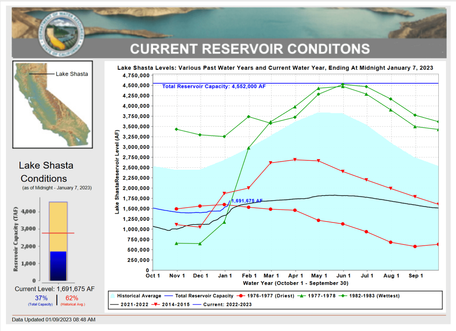 “Something unusual happened in Shasta County over the past eight days. North State residents have slogged through three years of a drought that has killed crops, emptied lakes and forced severe water cutbacks on residents who just wanted to water their lawns or grow a few tomatoes. The drought is not over, but the amount of rain that has fallen over the region since Jan. 1 has brought at least one small measurement of good news. As of Sunday morning, just under 3 inches of rain had fallen from Jan. 1 to Jan. 8 at the Redding Regional Airport, more than double the the 1.33 inches that normally falls this time of year, according to the National Weather Service. … ” Read more from the Redding Record Searchlight here: Lake Shasta level rises; Redding rainfall total twice normal since Jan. 1
Water accumulations force Butte County road closures
“With moderate rain Saturday and into Sunday, some of Butte County’s roads began to see water accumulation, with several already closed. Road closures in low-lying areas will almost certainly increase, as the National Weather Service predicts nearly 2 inches of rain in the Chico area, along with winds around 20 mph and gusts as high as 44 mph, in the 24-hour period starting early Monday morning. The harsh weather continues Tuesday with nearly another inch of rain and more strong winds on the slate; things begin to relax a little Wednesday, again with nearly an inch of rain expected but with wind gusts topping out around 23 mph. … ” Read more from the Chico Enterprise-Record here: Water accumulations force Butte County road closures
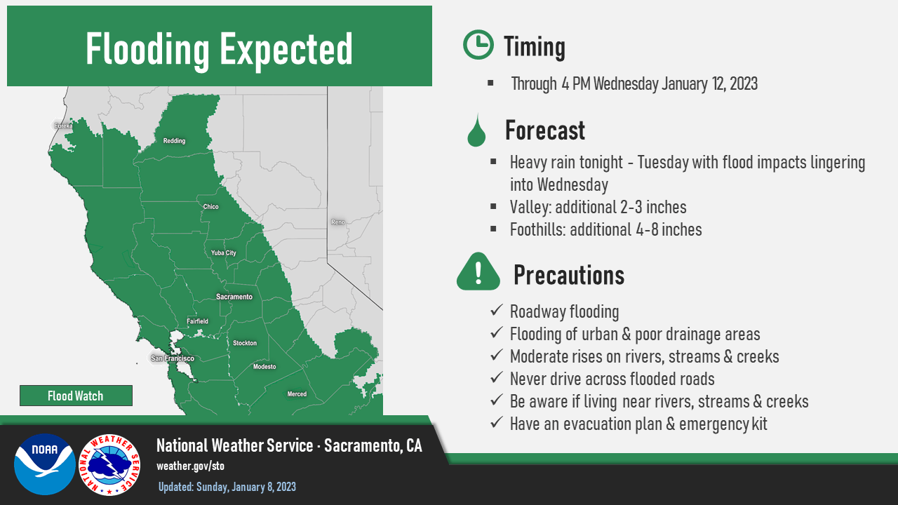
Flood, wind dangers as Sacramento endures fifth atmospheric river in three weeks
“The Sacramento Valley — and much of Northern California — has experienced a series of powerful and deadly storm systems over the past month. And it’s not over yet: The National Weather Service is forecasting more strong storm systems will roll through the region in the coming week. “We expect to see the worst of it in front of us,” Governor Gavin Newsom said Sunday. Emergency officials are urging people to use common sense, such as avoiding travel during the storm — and not to drive through water – and heeding evacuation orders when they arrive. … ” Read more from Capital Public Radio here: Flood, wind dangers as Sacramento endures fifth atmospheric river in three weeks
‘Leave now’ emergency managers plead with some California residents before next storm hits
““Leave now,” emergency managers warn Wilton, California residents. The next rainmaker is closing in on the state. It’s just the latest in the parade of storms fueled by the atmospheric river known as the Pineapple Express. As of Sunday, the parade has knocked out power to nearly half a million California homes and businesses. Wilton, bordered by the Cosumnes River, is in danger of becoming an island as inches more rain are expected to fall and runoff into the already swollen river. “Rising water may spill over onto the nearest roadways and cut off access to leave the area,” Sacramento County’s Office of Emergency Services posted. “Flooding in Wilton is imminent.” … ” Read more from Fox News here: ‘Leave now’ emergency managers plead with some California residents before next storm hits
NAPA/SONOMA
Overnight blast from Atmospheric River pushes swollen rivers to the brink
“The latest atmospheric river roared into the San Francisco Bay Area early Monday, triggering evacuation warnings and elevating the threat of flooding across the region. Of particular concern, the National Weather Service said, was flooding at the Russian River at Johnson’s Beach near Guerneville, Alameda Creek near Niles Canyon, Coyote Creek above Hwy 237 at Milpitas, the Big Sur River, Carmel River at Robles Del Rio, the San Lorenzo River at Big Trees and the Guadalupe River above Alamaden Expressway. At around 7 a.m., the San Lorenzo River went over its banks, triggering evacuations in the Felton Grove and Paradise Park areas. ... ” Read more from CBS News here: Overnight blast from Atmospheric River pushes swollen rivers to the brink
Column: The current of the Russian River isn’t its only pull
Kerry Benefield writes, “Jenn Otten stands on the deck of her Rio Nido home as a light rain falls during a welcome break between major storms. It’s cold. The temperature gauge reads 51 degrees. She’s wearing flip-flops. They give her an air of casual confidence — joie de vivre driven home by her easy laugh. But on the eve of what could be historic storms hitting the North Bay and threatening the Russian River and all who live on it, Otten has earned her confidence. It’s hard won. And it’s anything but casual. Otten’s confidence is born of being informed and prepared. “I have my generators going, I have my cords all set up, gas tanks are all full. Everything is covered,” she said. “I have tarped off some areas, I have stocked up on all supplies. I have a propane fireplace. I have everything I need.” … ” Read more from the Santa Rosa Press Democrat here: Column: The current of the Russian River isn’t its only pull
Lake Mendocino rising
 “On a soggy weekend all eyes are on Lake Mendocino, the rapidly filling reservoir behind Coyote Dam north of Ukiah. The surging east fork of the Russian River is fast filling up the lake, promising to end three years of drought conditions with current levels on Saturday reaching close to 100 percent of the target water supply level for the coming year, according to local and state water officials. “The rainfall is phenomenal. It has filled a big hole in the local water supply,” said Sean White, the city of Ukiah’s water director. The unexpected change is from a series of rainstorms that are expected to last into the coming week. By mid-January, Lake Mendocino’s water storage could be almost three times the amount measured just several weeks ago at the end of November. … ” Read more from the Ukiah Daily Journal here: Lake Mendocino rising
Not enough, then too much: North Bay’s recent punishing rains reflect reality of climate change extremes, experts say
“It’s a trick of the mind that a few days of rain can so quickly make us forget the statewide drought we’ve endured for three years. Not even a month ago, Lake Sonoma held the smallest amount of water since its creation in 1983 — a reflection of the region’s paltry rainfall and its water supply deficit. Now, it’s like Water World everywhere. The ground is squishy. Pounding rain has been hurtling from the sky for days. The most ephemeral streams, creeks and rivers run high, with significant flooding along the lower Russian River expected in mere days. What gives? And where exactly do we stand? The answer is a little unclear ... ” Read more from the Sonoma Gazette here: Not enough, then too much: North Bay’s recent punishing rains reflect reality of climate change extremes, experts say
BAY AREA
New atmospheric river drenches SF Bay Area: What to know
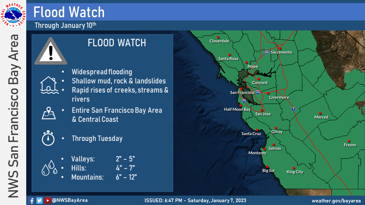 “Yet another California storm barreled into the San Francisco Bay Area on Monday, arriving a little earlier than was originally forecast and delivering heavy rain that is expected to continue through the morning. The wet weather is forecast to ease Monday afternoon before a second round of rain hits Monday evening and pushes into Tuesday, the National Weather Service said. Forecasters are calling this system an atmospheric river because it is rich in moisture and bringing periods of heavy rain. A flood watch and wind warning were in effect across the region on Monday morning. Just south of the Bay Area, the Big Sur coast is forecast to receive up to 12 inches of rain at the wettest locations in the mountains and mud slides and flooding in wildfire burn scars are a concern. “Threat to life is likely during these storms,” the weather service warned. … ” Read more from SF Gate here: New atmospheric river drenches SF Bay Area: What to know
New atmospheric river rolls in — here are the impacts, and when the Bay Area will dry out
“Another atmospheric river has rolled into the Bay Area, bringing the latest round of excessive rainfall, flooding and damaging wind gusts before the region gets a break and dries out from the storms.Potentially, this storm could give the Bay Area 2 to 4 inches of rain across the lower elevations. In the higher elevations, like the East Bay hills, mid-Peninsula hills, North Bay mountains and South Bay hills, 3 to 6 inches of rain could fall. The Santa Cruz Mountains could receive the most, up to 9 inches. This atmospheric river will move a band of substantial moisture across the Bay Area. Excessive runoff, mudslides and debris flow are likely because the ground soil is already saturated from recent rainfall. A flood watch will continue through Tuesday afternoon. … ” Read more from the San Francisco Chronicle here: New atmospheric river rolls in — here are the impacts, and when the Bay Area will dry out
Marin sponges up more rain as stronger storm barrels in
“Parts of Marin County received more than 2 inches of rain over the weekend as one drenching week transitioned to another. Forty-eight hour rain totals through Sunday afternoon included 2.67 inches on Barnabe Mountain, a peak above the San Geronimo Valley, said Matt Mehle, a meteorologist with the National Weather Service. Other totals included 2.04 inches in Woodacre, 2.04 inches in central Novato, 1.47 inches in Ross, 1.45 inches on Mount Tamalpais and 0.89 inches in Mill Valley. While Mount Tamalpais usually leads the county in rainfall totals, Mehle said thunderstorms passed through the northern part of the county over the weekend. … ” Read more from the Marin Independent Journal here: Marin sponges up more rain as stronger storm barrels in
CENTRAL COAST
Battered by storms, California coastal towns prepare for another deluge
“A barrage of powerful storms has surprised residents across Northern California with an unrelenting period of extreme weather stretching over weeks, with only small intervals of dryness. These storms have toppled trees, washed out streets and knocked out power for hundreds of thousands, but they have been particularly devastating to the Santa Cruz region, where prolonged rain and wind have combined with the unique topography to inflict recurring damage. Already drenched by a storm on Dec. 31, the Santa Cruz area — a tourist-friendly stretch of beaches on the Central Coast of California, 70 miles south of San Francisco — was again inundated in some parts with as much as five inches of rain and driving winds of up to 75 miles per hour on Wednesday and Thursday. And it was wearily preparing for more severe weather starting Monday. … ” Read more from the New York Times here: Battered by storms, California coastal towns prepare for another deluge
Cal Am files request with regulator to re-think earlier decision
“California American Water Co. is asking a state regulator to reconsider a decision that, according to Cal Am, left it millions of dollars short in the costs it will incur from building pipelines and other infrastructure when in coming years it buys water from the Pure Water Monterey expansion project. Late last year the California Public Utilities Commission, which regulates Cal Am because it is an investor-owned utility, approved a contract – called a water purchase agreement – for Cal Am to buy water produced from the expansion project, which is an estimated two years off. A few days later Cal Am notified the PUC that it was not signing the agreement, citing financial harm from the inadequate allowance for costs. The company claims that the recovery amount approved by the PUC will leave it roughly $24 million in arrears. … ” Read more from the Monterey Herald here: Cal Am files request with regulator to re-think earlier decision
Hammer-wielding scuba divers clear sea urchins from ocean floor to restore giant kelp in Monterey Bay
“On a recent Saturday morning, scuba divers Keith Rootsaert and Dan Schwartz splashed into the ocean just east of Old Fisherman’s Wharf, the chilly water swallowing the sounds of Monterey Bay as they descended. Upon reaching the seabed, each diver grabbed a spiky purple sea urchin, braced it against a rock and pulverized its center with a welding hammer — all in the name of saving giant kelp. The two divers needed to ensure the urchins were dead, but they didn’t have time to waste. Their goal was to kill hundreds of urchins apiece before the hourlong dive was over. “Urchin culling” is an intervention — not a massacre. The intervention is necessary because the urchins are devouring the kelp. … ” Read more from the Monterey Herald here: Hammer-wielding scuba divers clear sea urchins from ocean floor to restore giant kelp in Monterey Bay
Mandatory evacuations likely as next big storm takes aim at Santa Barbara County
“Public safety officials are warning people to remain vigilant and be prepared as another major winter storm takes aim at Santa Barbara County early in the coming week. On Sunday afternoon, an evacuation warning was issued for South Coast neighborhoods that were ordered vacated during last week’s big storm. That voluntary warning is likely to escalate to a mandatory order on Monday. National Weather Service forecasters are predicting that the new storm — expected to hit Monday and Tuesday — could drop 3-5 inches of rain along the South Coast, and as much as 8 inches in mountain areas. … ” Read more from Noozhawk here: Mandatory evacuations likely as next big storm takes aim at Santa Barbara County
SAN JOAQUIN VALLEY
Water levels rising in the Kern River, Isabella Lake and small lakes in Bakersfield
“Any way you measure it, the southern valley and the Kern County mountains have already seen a rip-roaring rainy season. And it’s not even close to being over. As of Thursday afternoon, the water level at Isabella Lake stood at 57,399 acre feet, a gain of 702 AF over the previous 24-hour period. Just one week before, the lake had been below 49,000 AF. Early last week, the upper Kern River was pouring more than 1,000 cubic feet per second of storm water into the lake — although one source said the river above the lake peaked at close to 2,500 cfs. As of Thursday afternoon, that massive volume had slowed to 661 cfs. By Saturday, the lake was poised to pass 60,000 acre feet and the water promised to continue rising. … ” Read more from the Bakersfield Californian here: Water levels rising in the Kern River, Isabella Lake and small lakes in Bakersfield
SOUTHERN CALIFORNIA
Southern California braces for powerful storm, with heavy rain, snow, wind
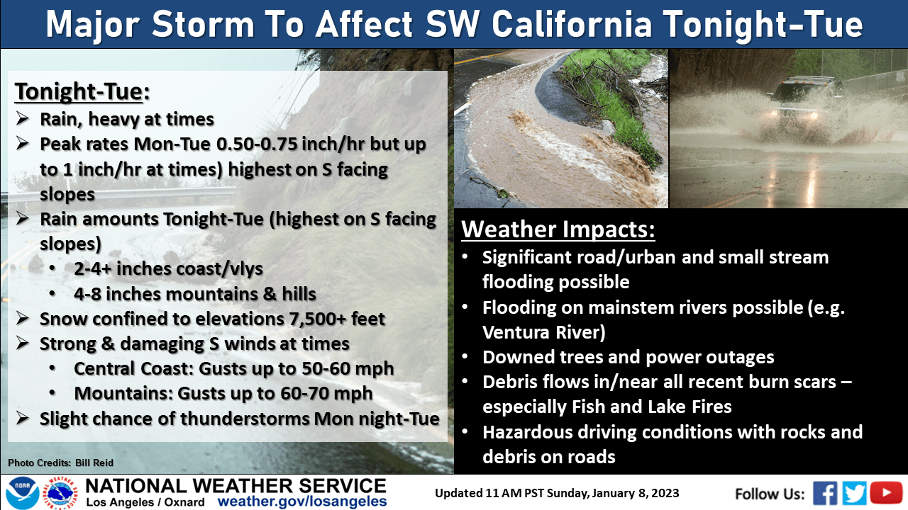 “A major storm is expected to hit much of Southern California on Monday, with forecasters again warning residents of massive waves and intense rip currents along the coast. The region is likely to see heavy rain and snow, and powerful winds blowing in from the north, according to the National Weather Service. The latest storm is part of a “relentless parade of atmospheric rivers,” long, narrow plumes of moisture in the atmosphere – like rivers in the sky. On Sunday afternoon, Governor Gavin Newsom, who declared a state of emergency last week before storms pounded Northern California, said he was in contact with the White House and would be asking for an official federal emergency declaration ahead of the new storm. “We will be reaching out formally within the hour,” Newsom said. … ” Read more from the OC Register here: Southern California braces for powerful storm, with heavy rain, snow, wind
Hundreds of deserted oil and gas wells in Southern California could soon get plugged. Thousands will remain.
“One apparently is hiding under the driveway of a million-dollar home in Placentia. Another lurks beneath a parking lot at Ontario International Airport. And another is under a commercial building in Culver City — much to the surprise of the upscale window company doing business there. Thanks to its once expansive, 150-year-old oil and gas industry, Southern California has one of the nation’s highest concentrations of so-called “orphan wells,” or wells that companies abandoned without first plugging them up for safety. The state has documented nearly 2,000 orphan wells in Los Angeles, Orange, San Bernardino and Riverside counties alone, while estimating that thousands more could be paved over, unrecorded, and waiting to be rediscovered. … Starting in 2021, after federal lawmakers announced they’d be doling out $4.7 billion in coming years to help plug such wells, California rushed to account for more, with at least 5,300 orphan wells now on record statewide. … ” Read more from the OC Register here: Hundreds of deserted oil and gas wells in Southern California could soon get plugged. Thousands will remain.
SAN DIEGO
North County coastal cities clean up after storms, high tides
“Coastal North County cities took advantage of Friday’s sunshine to clean up from minor flooding and prepare for the next round of rain and high tides. Work crews blocked off one lane of Carlsbad Boulevard, part of the state’s scenic Highway 101, south of Palomar Airport Road for a few hours to clean up sand and rocks washed onto the roadway by the morning’s crashing surf. “We are seeing some flooding in low-lying areas and have posted signs as needed or closed lanes temporarily,” Carlsbad Communications and Engagement Director Kristina Ray said Thursday. ... ” Read more from the San Diego Union-Tribune here: North County coastal cities clean up after storms, high tides
Along the Colorado River …
Drought and the Colorado River: Localizing water in Los Angeles
 Erik Porse and Stephanie Pincetl write, “In October 2022, water agencies in Southern California with Colorado River water rights announced plans to reduce water diversions. The agencies offered voluntary conservation of 400,000 acre-feet per year through 2026. This annual total is nearly 10% of the state’s total annual usage rights for the Colorado River. The cutbacks help prepare for long-term implications of climate change for the river’s management, which are starting to be acknowledged. In urban Southern California, an important aspect of this need is reducing imported water reliance through investments in local water resources. … ” Read more from the California Water Blog here: Drought and the Colorado River: Localizing Water in Los Angeles
Brenda Burman begins as new Central Arizona Project general manager amid historic water cuts
“The Central Arizona Project, which delivers water from the Colorado River to nearly 6 million Arizonans, has a new general manager. Brenda Burman begins leading the agency this week. The change in leadership comes as the state faces unprecedented cuts to water supply. Severe, prolonged drought means the federal government is cutting Arizona’s Colorado River water supply about 21% this year. Burman told KJZZ News she hopes to work collaboratively with the state and its water stakeholders. She said she’s optimistic to see Arizona agricultural and municipal water users investing more in efficiency strategies. “That’s an important step, but there’s going to be very difficult decisions in 2023,” Burman said. … ” Read more from KJZZ here: Brenda Burman begins as new Central Arizona Project general manager amid historic water cuts
Utah commentary: We need new ways of dealing with water
David Op’t Hof, a retired educator, writes, “The nightly news has reported on the devastating snow that hit parts of the Northeast. Power outages, stranded motorists, disrupted air travel. At that point more than 30 people had died. No one can prevent such events, but snowplows, first responders and power companies have been busy cleaning up the mess. By now, there must be huge piles of snow all over the Northeast. What happens when that all melts? Will there be extensive flooding? Out West, we have had a wetter winter than in recent years. While this season’s rain and snow will help our water situation, experts say it won’t end the drought. … We need our elected representatives to get busy on a coordinated water response in which different parts of the country help each other with their water problems. For example, couldn’t the snow piling up in the East be loaded onto rail cars and shipped west to be dumped into the Great Salt Lake? … ” Read more from the Salt Lake Tribune here: Utah commentary: We need new ways of dealing with water
Researchers solve one of the Borderlands’ biggest water puzzles
“The U.S. and Mexico share underground water basins that span more than 121,500 square miles of the Borderlands. But the two countries have no regulations for managing those common aquifers, in part, because historically very little was known about them. That’s changing. On Dec. 28, researchers released the first complete map of the groundwater basins that span the U.S.-Mexico boundary. It demarcates 72 shared aquifers — a striking contrast to the countries’ official count of 11. With water becoming an increasingly precious resource in the southwestern U.S. and northern Mexico, the researchers hope the new map will provide a basis for developing a binational legal framework to regulate the underground waters’ management. “The lack of a legal framework that regulates the management of transboundary groundwater resources promotes the unsustainable use and exploitation of the resource,” wrote the authors, Rosario Sánchez, a scientist at the Texas Water Resources Institute, and Laura Rodríguez, a graduate student at Texas A&M University. … ” Read more from High Country News here: Researchers solve one of the Borderlands’ biggest water puzzles
In national water news today …
WRDA 2022 act revises levee safety, inland waterway programs
“In mid-December, Congress approved the critical water resources legislation known as the Water Resources Development Act of 2022 (H.R. 7776), which authorizes the projects and policies to be undertaken by the U.S. Army Corps of Engineers. The WRDA 2022 legislation is strongly supported by ASCE and addresses several of its priorities, including levee safety, a national inventory of low-head dams, and a change to the cost-share formula for inland waterway projects. The WRDA also addresses increased resiliency for water resources infrastructure. ... ” Continue reading at Civil Engineering Source here: WRDA 2022 act revises levee safety, inland waterway programs
Climate attribution tools critical for understanding extreme events
“A combination heat and drought event in the western U.S., simultaneous ocean and land heat waves in the northwestern region of the Pacific Ocean, a South Korean heat wave that was off the charts and wildfires in Cape Town, South Africa, were some of the recent extreme weather events made more likely by human-caused climate change, according to new research offsite link posted today on the Bulletin of the American Meteorological Society (BAMS) website. Now in its 11th year, Explaining Extreme Events from a Climate Perspective presents new peer-reviewed analyses of extreme weather and climate across the world during 2021 and 2022. It features research from NOAA and other leading international climate scientists on extreme weather occurring across the globe, including the U.S., U.K., South Korea and China. Research teams use both historical observations and model simulations to determine whether — and by how much — climate change may have influenced particular extreme weather events. … ” Read more from NOAA here: Climate attribution tools critical for understanding extreme events
More news and commentary in the weekend edition …
-

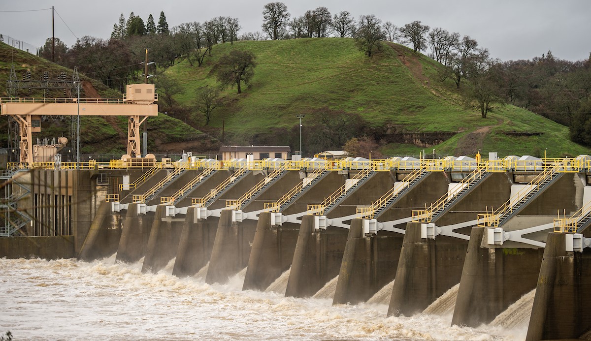
Water is released from Lake Natoma at Nimbus Dam into the American River in Sacramento County, California as a precaution against flooding after an atmospheric river storm dumped heavy rain and snow across Northern California. Photo taken January 5, 2023 by Jonathan Wong / DWR California’s not done. Three more atmospheric rivers are on the way.
- Dangers to life, property remain high in California as storm onslaught continues
- California water officials say they are prepared for record flooding as rain continues
- Why we can — and cannot — collect rainwater in places like California
- Column: On this flooded island of homeless people, climate change has never been more real
- In 1997, California was devastated by historic floods
- Sites Reservoir receives more funding as California experiences substantial rainstorms
- Retiring Delta Watermaster advises “pray for rain” but “plan for drought”
- Flood watch issued for Sacramento Valley
- Roseville using aquifer storage to retain excess water from storms
- Russian River forecast to hit 39 feet during next series of storms
- Weather service warns that several rivers in Bay Area could flood next week
- Major flooding and evacuations from California storm rock Stinson Beach
- Marin water reservoir system near capacity amid storms
- Storms bring river flows, frustration for San Joaquin Valley water managers
- LADWP working to capture rain water after SoCal storm
- And more …
Click here for the weekend digest.
Also on Maven’s Notebook today …
NOTICE: Draft guidelines for expedited drinking water grant funding program
NOTICE of 180-Day Temporary Permit Application T033344 / Permit Order 21435 – Merced County
NOTICE: State Water Board Racial Equity Action Plan – Final Draft Available Online
SAN JOAQUIN RIVER RESTORATION: Restoration Flows cease, Flood Flows begin

