
On the calendar today …
- WEBINAR: Flyway Nights – Fremont Weir Big Notch Project at 7pm. The Yolo Bypass Salmonid Habitat Restoration and Fish Passage Project, or Big Notch Project, is a joint State and federal project between the California Department of Water Resources (DWR) and the United States Bureau of Reclamation (Reclamation). This project provides essential benefits to various native fish species, including threatened and endangered Chinook salmon, steelhead, and sturgeon. Josh Martinez is a Senior Environmental Scientist with the California Department of Water Resources. As manager of the Restoration Ecology Unit, Josh has spent the last 14 years working on habitat restoration and fish passage projects in the Yolo Bypass. Click here to register.
California storms …
‘Bomb cyclone’ taking aim at California prompts state of emergency
 “California Governor Gavin Newsom declared a state of emergency Wednesday as a bomb cyclone storm makes landfall in Northern California and amid a string of unusually strong winter storms that have battered the Golden State. The National Weather Service is forecasting heavy rain and snow, strong wind and the potential for flooding as the Pineapple Express moves east into California. With rain and gusty winds already underway, heavy snow and rain is expected into Thursday morning in Northern California, arriving into Thursday night in Southern California. Flooding could extend into the weekend with more storms on the way, and there is potential for widespread flooding, debris, downed trees and power outages. … ” Read more from the Courthouse News Service here: ‘Bomb cyclone’ taking aim at California prompts state of emergency
The atmospheric river hitting California as seen from space: How to interpret it
“Satellite imagery from midday on Wednesday shows an intense low-pressure system spinning counterclockwise off the Northern California coast. As it spins, it draws in a robust plume of moisture, called an atmospheric river, from the Pacific Ocean. Atmospheric rivers are concentrated streams of water vapor about 100 to 250 miles wide in the middle and lower levels of the atmosphere. They can transport water at a rate per second equivalent to 25 Mississippi Rivers or 2.5 Amazon Rivers, according to Marty Ralph, an expert at the Scripps Institution of Oceanography in San Diego. They’re like a continuous channel of moisture streaming across the ocean without interruption. When this atmospheric stream, bloated with moisture, meets California’s mountainous coastal topography, it is forced up and over the higher terrain. This is called orographic lift. … ” Read more from the LA Times here: The atmospheric river hitting California as seen from space: How to interpret it | Read via AOL
Ca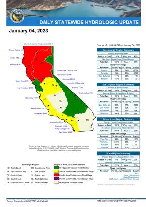 lifornia ‘storm train’ may rival notorious El Niño winter of 1997–98
“The parade of severe storms slamming into Northern California could lead to one of the strongest seasons since the wild El Niño-fueled winter of 1997–98, given the relentless pace of weather systems marching in with little relief. And this isn’t even an El Niño year. Already, Northern California and the Central Valley have been hit by a number of history-making storms, pouring floodwaters into homes, cars, restaurants, a nursing home, freeways and underpasses. At least three deaths have been reported: a 72-year-old struck by a falling tree in Santa Cruz on New Year’s Eve and two people found near where the Cosumnes River flooded in Sacramento County, inundating Highway 99. … ” Read more from the LA Times here: California ‘storm train’ may rival notorious El Niño winter of 1997–98
DWR prepares for more storms and potential flooding
“The California Department of Water Resources (DWR) is preparing for a series of storms in the next ten days that could potentially bring additional flooding to communities already inundated by recent downpours. The storm battering the state today is the third in a series of atmospheric river storms that have impacted northern California in the space of a week. Earlier today, DWR Director Karla Nemeth participated in a media briefing with California Natural Resources Agency Secretary Wade Crowfoot and officials from the California Office of Emergency Services (CalOES). … ” Read more from DWR News here: DWR prepares for more storms and potential flooding
USGS crews continue to measure record-high streamflow in California
 “These measurements provide information that protect life, property, and the environment including uses for water supply and management, monitoring floods and droughts, bridge and road design, determination of flood risk and many recreational activities. “Heavy rains and hazardous weather conditions continue in northern California this week,” said Mark Dickman, Associate Director of Data for the USGS California Water Science Center. “Streamflows have been very high, and we expect more over parts of the region the next several days.” USGS crews made 77 streamflow measurements at 58 streamgages between December 31, 2022 and January 2, 2023, and recorded 13 preliminary record-high streamflow measurements in northern California. … ” Read more from the USGS here: USGS crews continue to measure record-high streamflow in California
EXPLORE MORE STORM COVERAGE:
- Hurricane-force wind gusts blow through California as part of the ‘bomb cyclone’ hitting the coast, from CNN
- ‘Rivers in the sky’: Graphics show atmospheric river soaking California’s Bay Area, from USA Today
- String of brutal atmospheric rivers imperils a California already weakened by drought, from the LA Times | Read via AOL News
- Massive storm lashes Northern California, bringing winds, power outages, evacuations, from the LA Times
- Soaked California Faces Another Deluge Driven by Bomb Cyclone, from Bloomberg
- These images capture the sheer power and beauty of the bomb cyclone off California, from the San Francisco Chronicle
In other California water news today …
California’s aging levees are being pushed to the breaking point by climate whiplash
“The pounding rains of New Year’s Eve had ceased, but the pastures, freeways and neighborhoods surrounding the tiny community of Wilton continued to disappear beneath a vast, growing ocean of muddy water that left only the roofs of sunken vehicles visible to rescue helicopters. It was a chilling vision of just how vulnerable California’s network of rural levees has become in an age of climate extremes. By Wednesday, nearly a dozen earthen embankments along the Cosumnes River near Sacramento had been breached, and three people had been found dead inside or next to submerged vehicles. Experts say such failures are all but inevitable as California’s aging levee system whipsaws between desiccating drought and intense downpours. … ” Read more from the LA Times here: California’s aging levees are being pushed to the breaking point by climate whiplash
A Sacramento County levee has a hole the size of a football field — What it will cost to fix it
“Reclamation district officials in Wilton said Tuesday that it will cost $1.5 million to fill a gaping hole the size of a football field in the Cosumnes River levee, one of 11 trouble spots they have identified so far. “They’ve got to solidify a road just to get all those heavy trucks in,” said Mark Hite, a trustee for Reclamation District 800 Cosumnes, which manages the levees in the area. “They’ve got trucks bringing in gravel and stuff so that the bigger trucks bringing in the big rock can get access. And they’ve already started to close the gap.” While there are three breaches among the 11 hot spots, Hite said, there are other types of problems. For instance, he said, the crest of the levee walls crumbled in some places as floodwaters rolled over it and wore away soil, sand, gravel and boulders. … ” Read more from the Sacramento Bee here: A Sacramento County levee has a hole the size of a football field — What it will cost to fix it
Floods show California’s climate dilemma: Fight the water, or pull back?
“As California battles a second week of lashing rain and snow that have flooded communities, broken levees and toppled power lines, the state is facing questions about whether its approach to handling crippling storms is suited to 21st-century climate threats. For decades, federal and state planners built dams and levees in California to store water and keep it at bay. But as climate change increases the risk of stronger and more destructive storms — like the one that was battering Northern California on Wednesday — experts and some policymakers are urging another approach: giving rivers room to overflow. … ” Read more from the New York Times here: Floods show California’s climate dilemma: Fight the water, or pull back?
With all this rain, is California still in a drought?
“After the driest start to any year on record, California ended 2022 with snow-capped mountains, soaked roadways and flood warnings. The soggy weather continues into 2023, with this week’s bomb cyclone storm dumping several inches of rain. So what difference does that make in California’s extended drought? Experts say the wet winter makes a dent, but there’s still a long way to go for the state’s water supplies to be built back up to sufficient levels. “Rain in California will certainly help, but it won’t alleviate the drought overall in the western United States,” said Lowell Stott, professor of earth sciences at the University of Southern California. ... ” Read more from ABC 7 here: With all this rain, is California still in a drought?
SEE ALSO: How will the ‘bomb cyclone’ affect California’s drought? Experts weigh in, from KTLA
California’s water reservoirs still have a lot of room, even after the series of storms
“Major water supply reservoirs around Northern California still have plenty of room, even after the recent series of storms. Still, some reservoirs are up relative to their seasonal average. As of Thursday, Folsom Lake is at 421.20′, which is 55 percent of total capacity but 133 percent of the historical average for the date. Camanche Lake is also reading at 71 percent of capacity, good for 120 percent of its historic average. … ” Read more from CBS Sacramento here: California’s water reservoirs still have a lot of room, even after the series of storms
The power of atmospheric rivers, explained
“Just days into 2023, Californians braced for the latest in a series of atmospheric river storms that National Weather Service forecasters called “impressive,” “debilitating” and “brutal.” “To put it simply, this will likely be one of the most impactful systems on a widespread scale that this meteorologist has seen in a long while,” an unnamed Bay Area meteorologist wrote in the agency’s ongoing forecast discussion. Much of Northern California is still recovering from a New Year’s Eve storm that dumped widespread, historic rain: One downtown San Francisco monitor recorded 5.46 inches in 24 hours, just shy of the wettest day in 170 years of record-keeping. Another storm is forecast for Jan. 4 and 5, and meteorologists are watching several more that appear poised to follow. … ” Read more from the High Country News here: The power of atmospheric rivers, explained
Early estimates projected a dry winter – one expert explains the wet conditions
“Wet weather continues and the forecast calls for serious rain tonight – KRCB News spoke with Rick Canepa, meteorologist with the National Weather Service’s Bay Area office in Monterey about it. Canepa said a storm of this strength is not unheard of. “I mean, we quickly reference a benchmark storm back in December, 1995, taking a similar path, similar depth, that one produced widespread heavy rain and damaging winds across San Francisco Bay area,” Canepa said. “It leveled something like a thousand trees across Golden Gate Park caused extensive damage. The wind gusts were like over a hundred miles an hour at Angel Island.” … ” Read more from Northern California Public Media here: Early estimates projected a dry winter – one expert explains the wet conditions
Sites Reservoir awarded $80 million in federal funds
 “Officials said Wednesday that the Sites Reservoir project, which could provide 1.5 million acre-feet of additional water storage capacity, was awarded $80 million in federal funding from the Bureau of Reclamation via the Water Infrastructure Improvements for the Nation Act. This federal initiative provides grants for water supply infrastructure that promotes drought resilience for rural communities and agriculture, urban areas, public health and the environment. The project, which has been in the works for more than 60 years, hopes to turn the Sites Valley, located 10 miles west of Maxwell where Colusa and Glenn counties meet, into a state-of-the-art off-stream water storage facility that captures and stores stormwater flows in the Sacramento River – after all other water rights and regulatory requirements are met – for release in dry and critical years for environmental use and for communities, farms and businesses statewide to utilize when needed, the Appeal previously reported. … ” Read more from the Appeal-Democrat here: Sites Reservoir awarded $80 million in federal funds
How the LandFlex incentive program can assist dairy farmers
“The LandFlex incentive program offers farmers financial support as part of the effort to address water availability. Producers in critically over drafted basins will have the opportunity to enroll in different incentive options. Chief Executive Officer of Western United Dairies, Anja Raudabaugh explained how the program would be beneficial for dairy farmers. “If a farmer is double cropping wheat and corn, for example, you’re looking on average, depending on your basin, at about five acre-feet per acre of consumptive water use from the aquifer. If you wanted to transition to, for example, upcycling byproducts, nonhuman consumables like almond hulls, citrus pulp and peel, bakery waste,” Raudabaugh noted, “DWR will pay him by the acre approximately $2,200, and depending on what you’re transitioning to, the transition payment goes up or down.” … ” Read more from Ag Net West here: How the LandFlex incentive program can assist dairy farmers
Using satellites to track groundwater depletion in California
“Researchers have pioneered the use of a tool that can track the loss of groundwater in California’s Central Valley by measuring how much the Earth is sinking. Home to one of the largest groundwater basins in the western United States, the Central Valley supplies about one-fifth of the nation’s groundwater demand, a large part of which is used to provide crop irrigation and aid agricultural production. The same area also accounts for about 75% of the region’s subsidence – the scientific term for the gradual sinking of an area of land. The leading cause of subsidence is the removal or disturbance of groundwater, which is found underground in soil and between rocks and sand. … ” Read more from Stanford here: Using satellites to track groundwater depletion in California
Modifying a river channel to boost salmon productivity
 “Along the banks of the Sacramento River near Redding, the ancestral home of Chinook salmon, a major project is making the waters more hospitable for the juvenile fish as they begin their annual migration downstream toward the Pacific Ocean. Crews have carved a side river channel and supplemented the main riverbed with gravel. From there, it’s a matter of watching the natural process unfold. The results are “almost immediate,” said Aurelia Gonzalez, program manager with the Sacramento River Forum. “Fish come back,” she said. “You provide the habitat and they’re there.” The Kapusta 1B Side Channel Project is one of many projects funded under a $10 million Central Valley Project Improvement Act competitive solicitation to restore fish habitat for critically endangered winter-run Chinook salmon. … ” Read more from the Bureau of Reclamation here: Modifying a river channel to boost salmon productivity
Desert Research Institute leading $5 million regional climate adaptation project
“DRI is partnering with Scripps Institution of Oceanography to build climate resiliency through the California Nevada Adaptation Program (CNAP). The impacts of climate change have been acute in California and Nevada, with most of the last two decades spent in extended drought conditions and 2021 wildfires producing Reno’s worst recorded air quality in the 21st century. Adapting to these challenges will require not only focused research to better predict climatic events, but will also depend on empowering local communities to use this knowledge to make informed decisions in the face of adversity. With $5 million in funding from NOAA’s Climate Adaptation Partners initiative, the California Nevada Adaptation Program (CNAP) will spend the next five years bringing together researchers, community members, and practitioners to cooperatively conduct research and identify solutions. … ” Read more from the Desert Research Institute here: Desert Research Institute leading $5 million regional climate adaptation project
In commentary today …
Those who forget California water history are doomed to repeat it
Dennis Wyatt, editor of the Manteca Bulletin, writes, “High winds. The potential for up to 3 inches of rain in 48 hours. Heavy storms in the past three weeks that have saturated the ground. Nobody is thinking about the drought. Go back a few months. No rain for months. A dismal Sierra snowpack on April 1 that was 38 percent of the historic average. Groundwater tables dropping farther. In some areas, wells drying up. Reservoirs with water rings that are going downhill from being classified as lakes to puddle status. Water restrictions. Dying or dead lawns. Fallow farmland. Orchards dying. Rest assured no one was worried about flooding in mid-August. But here we are — again. … ” Read more from the Manteca Bulletin here: Those who forget California water history are doomed to repeat it
Recent flooding shows the need for water storage
The Southern California News Group editorial board writes, “As Californians struggled to deal with a grueling drought that has led to water rationing and other extreme water-conservation measures, Mother Nature has this week intervened with an atmospheric river that has led to massive rainfalls and flooding — especially up north. This cycle of drought and flooding is nothing new. “California summers were characterized by the coughing in the pipes that meant the well was dry, and California winters by all-night watches on rivers about to crest,” wrote Joan Didion in her 1977 essay, “Holy Water.” Unfortunately, California has left itself dependent on the weather (or climate, if you prefer) because it hasn’t built significant water infrastructure since the time that essay was published — when the state had roughly 18 million fewer residents. … ” Read more from the OC Register here: Recent flooding shows the need for water storage
In praise of the monthly water bill
Kathryn Sorensen, current director of research at the Kyl Center for Water Policy, Arizona State University; Bidtah Becker, director of the Navajo Nation Division of Natural Resources, and Manny Teodoro, associate professor of public affairs at the University of Wisconsin-Madison, write, “The cost of delivering safe, clean tap water to every household and business in a community is massive. In fact, it may be among the most expensive of all human undertakings. That is why only the wealthiest countries have achieved it at high rates and why 2 billion people on our planet still lack it. Paying the monthly bill that comes with good tap water service is unpleasant, but it beats the alternatives. While it would be nice if some benevolent entity would bear the cost of delivering safe, clean tap water, the reality is that communities that rely on someone else to pay for their water systems often have inadequate or failing service. Indeed, there are plenty of people who would love to pay a water bill because it would mean that they have access to a functioning community water system. Instead, many Americans must haul their own water, depend on contaminated household wells or rely on bottled water handouts on the street. ... ” Read more from The Hill here: In praise of the monthly water bill
In regional water news and commentary today …
NORTH COAST
Lawsuit filed against Klamath River dam removal project
“A board member of the Siskiyou County Water Users Association has filed a lawsuit against the secretary of the California Natural Resources Agency. The lawsuit claims the secretary is illegally using taxpayer money to fund the historic dam removal project. “The secretary of natural resources has authority over the implementation of anything that affects wild and scenic rivers. He’s also… in charge of the bond money,” said Anthony Intiso, who filed the lawsuit. Intiso is personally suing Wade Crowfoot, the secretary of the California Natural Resources Agency. Intiso says his primary concern with the removal project is how it’s being funded by the state of California. His lawsuit cites California’s Water Quality, Supply and Infrastructure Improvement Act of 2014, claiming the project funding is illegal expenditure of tax money. … ” Read more from Channel 12 here: Lawsuit filed against Klamath River dam removal project
Eureka City Council reviews big project to restore fish passage through Cooper Gulch
“The Eureka City Council convened for its first meeting of the year on Tuesday evening. Although it was a relatively light agenda with few action items, the council had the chance to explore some interesting topics, including “fishutopias,” the community benefits of participatory budgeting and the possibility of decriminalizing “natural” psychedelics. Wouldn’t it be nice if our local fish populations had some more habitat to enjoy around Eureka? Fewer barriers and some big fish-friendly culverts to swim through, perhaps? City staff unveiled a project proposal on Tuesday night that would do just that. The First Slough Fish Passage and Preservation Connectivity Project is a big restoration project that would remove barriers to fish passage along the First Slough, a tributary finger of the Eureka Slough, and allow fish to migrate through Cooper Gulch and upstream to the Eureka High School campus. … ” Read more from the Lost Coast Outpost here: Eureka City Council reviews big project to restore fish passage through Cooper Gulch
MOUNTAIN COUNTIES
What is a “bomb cyclone” and what does it mean for Lake Tahoe?
“A term that has been getting a lot of coverage with the incoming storm is “bomb cyclone,” but was is it? A “bomb cyclone” is an area of a low-pressure system that intensifies by 24 millibars within 24 hours (millibars are a unit used to measure atmospheric pressure). This is not a new meteorological term and has been around for quite some time, but it hadn’t been used much. It is more common in the northeast where they see rapidly changing pressure systems more often, but it happens in the west as well. … For the Lake Tahoe Basin and Western Nevada, this storm looks like the New Year’s Eve storm but it shouldn’t be as crippling based on the cyclone features. Snow forecast: 8 to 14 inches at Lake Tahoe, except 1 to 2 feet above 7000 feet. Localized amounts up to 3 feet are expected for the Sierra crest. Winds could be 100 mph over Sierra ridgelines with gusts up to 40 mph at lake level. … ” Read more from South Tahoe Now here: What is a “bomb cyclone” and what does it mean for Lake Tahoe?
SACRAMENTO VALLEY
Over 150 Chinook Salmon released in the Sacramento River Tuesday
“For the second consecutive year, Turtle Bay Exploration Park teamed up with Coleman Fish Hatchery to release more than 150 Chinook Salmon into the Sacramento River Tuesday evening as part of a Conservation Head Start Program. KRCR talked to Sharon Clay the Curator of Animal Programs at Turtle Bay and she explained why the Salmon are important to the area. “The Chinook Salmon in the Sacramento River are super special to our community because there are different runs of Chinook salmon and most rivers will have one or two of them, but the Sacramento river through here actually has all four runs of the Chinook salmon and Chinook Salmon are so important because they are important to the entire environment, so we really need them in our system.” … ” Read more from KRCR here: Over 150 Chinook Salmon released in the Sacramento River Tuesday
Reclamation announces the availability of Section 215 water for American River Division
 “The Bureau of Reclamation has determined that recent rainfall and storage conditions in Folsom Reservoir make non-storable (Section 215) water available on the American River. Section 215 water is expected to be available through mid-January; however, the amount of water will depend on actual hydrologic and operational conditions over the next week. Rainfall over the past week has increased Folsom Reservoir levels which make additional releases necessary in accordance with the U.S. Army Corps of Engineers’ flood-control criteria; therefore, Reclamation is declaring the availability of Section 215 water for those that can enter into a “Temporary Water Service” contract with Reclamation. … ” Read more from the Bureau of Reclamation here: Reclamation announces the availability of Section 215 water for American River Division
Some water getting through gates at Sacramento Weir
“Water can be seen coming over the gates at the Sacramento Weir on Wednesday as the leading edge of a significant storm hits Northern California. The weir is one of several along the Sacramento River that act as a flood safety valve. Notably, the Sacramento Weir is the only one that has locks that need to be released manually. Standard procedure for the locks to be released is when the Sacramento River water level at I Street reaches 27.5′ and is predicted to keep rising. The level is a little under 24′ on Wednesday, but the California Nevada River Forecast Center forecasts show it could reach about 26.6′ by Friday. ... ” Read more from CBS News here: Some water getting through gates at Sacramento Weir
Flooding at Wilton Rancheria in southern Sacramento County endangers sacred tribal burial grounds
“Heavy rains from ongoing storms have disturbed ancient burial sites around Wilton Rancheria in southern Sacramento County. Parts of the Cosumnes River run through the Rancheria which flooded after heavy rain over the New Year’s weekend. Now, tribal leaders are concerned about continued flooding from the river. “The Cosumnes River’s very important to the tribe’s Miwok and Nisenan ancestors, and we know there are burials nearby,” said Dahlton Brown, Executive Director of Administration for Wilton Rancheria. “Our concern is with the localized flooding, any of those burials being disturbed and possibly misplaced.” … ” Read more from Capital Public Radio here: Flooding at Wilton Rancheria in southern Sacramento County endangers sacred tribal burial grounds
NAPA/SONOMA
Flood fears rise as drenching rains and storms on tap threaten Sonoma County and North Coast
“Drenching rain and powerful winds lashed the North Coast as the leading edge of a potent storm barreled into the region and across much of Northern and Central California on Wednesday, submerging roads, felling trees and cutting power to thousands of people in the area before the day was out. The much-dreaded storm — a moisture-laden atmospheric river powered by steeply dropping pressure known as a “bomb cyclone” — impacted travel and activity across Sonoma County and beyond, as drought-weakened trees fell across roads, particularly along Highway 1, and runoff pooled on ground saturated from earlier rains. Late Wednesday, county officials issued an evacuation warning for low-lying areas along the Russian River stretching from west of Healdsburg to Jenner on the coast. … ” Read more from the Santa Rosa Press Democrat here: Flood fears rise as drenching rains and storms on tap threaten Sonoma County and North Coast
SEE ALSO:
- Sonoma County issues evacuation warning for low-lying areas along the Russian River, from the County of Sonoma
- As powerful storms deluge California, a river community evacuates — again, from the Washington Post
- Russian River expected to hit flood stage on Thursday, from the San Francisco Chronicle
BAY AREA
More atmospheric river storms are headed for the Bay Area. What that means for flood risk and the drought.
 “The atmospheric river storm that was bearing down on the Bay Area Wednesday night and Thursday morning raised concerns about mudslides, power outages and other problems. And a series of new storms headed our way this weekend means the end is not yet in sight. The mid-week storm was the third atmospheric river storm since last Friday. Scientists said conditions are lining up for a series of additional “pineapple express” storms in the next few days that could create conditions not seen since 2017. That year, multiple atmospheric river storms drenched California in succession, culminating with a massive one in mid-February that ended the 2012-16 drought, wrecked the spillway at Oroville Dam and caused $100 million in flood damage in downtown San Jose. … ” Read more from the San Jose Mercury News here: More atmospheric river storms are headed for the Bay Area. What that means for flood risk and the drought. | Read via MSN News
SEE ALSO: Wet Weather Could Help Bay Area Water Shortage—But Will It Solve Drought?, from the SF Standard
‘The problem is too much, too fast’: Officials keep eye on rising reservoirs
“Recent storms have filled up reservoirs across the drought-stricken Bay Area and California, but that may be a cause for concern with more wet weather on the way. As NBC Bay Area Meteorologist Kari Hall points out, a reservoir at 100% capacity now means the rain in the forecast will have nowhere to go except downstream. “We are possibly going to see too much of a good thing,” Hall said. “The problem is too much, too fast. The smaller reservoirs, like Uvas Reservoir, overtopped its banks over the weekend. You’re losing valuable water because it didn’t have time to really store it properly.” … ” Read more from NBC Bay Area here: ‘The problem is too much, too fast’: Officials keep eye on rising reservoirs
How to check Bay Area river levels for flooding in real time
“As steady rain pours over the Bay Area Wednesday and Thursday, flooding is likely top of mind for many residents. The National Weather Service is already projecting that the Russian River will flood on Friday, and it’s likely that many rivers, creeks and streams across Northern California will overrun their banks this week. The National Oceanic and Atmospheric Administration keeps a real-time database of California rivers at various points. You can check to see current water levels, as well as forecasts for when the river will crest. There’s also the flood stage for key points along the river. … ” Read more from SF Gate here: How to check Bay Area river levels for flooding in real time
Why S.F.’s $600 million plan to prevent floods won’t help during this week’s storm
“San Francisco officials are furiously working to prepare for the massive storm expected to hit the city beginning early Wednesday, erecting flood barriers and piling up sandbags to help prevent catastrophic damage to residents and businesses. While the city is in the midst of three major infrastructure projects — totaling more than $600 million — to help low-lying neighborhoods that are particularly vulnerable to extreme flood damage, those projects are still years from completion and will not protect those areas from the brunt of this week’s storm. Instead, the business owners and residents in these neighborhoods — which includes areas in the Mission, West Portal and around Lower Alemany — will largely have to rely on old-school tactics to protect their properties, like flood barriers and sandbags. … ” Read more from the San Francisco Chronicle here: Why S.F.’s $600 million plan to prevent floods won’t help during this week’s storm
S.F. blames National Weather Service for city’s insufficient storm planning last week. NWS disagrees
“San Francisco experienced historic rainfall and widespread flooding on New Year’s Eve, stranding motorists on roads covered in murky water, flooding homes and forcing business closures. City officials squarely blamed a lack of preparation on incorrect weather forecasts from the National Weather Service — but the agency disputes that and has communications with the city to back it up. “We were under the impression and notified by our National Weather Service that we could anticipate not even an inch of rain,” Mayor London Breed said at a press conference on Tuesday. Instead, San Francisco saw its second wettest day on record, with a staggering 5.54 inches falling within a 24 hour period. The discrepancy forced the city to scramble after the rain began, officials say. … ” Read more from the San Francisco Chronicle here: S.F. blames National Weather Service for city’s insufficient storm planning last week. NWS disagrees
Palo Alto: Heavy storms, flood risks renew sense of urgency over delayed San Francisquito Creek projects
“Xenia Hammer and her neighbors in Palo Alto’s Crescent Park neighborhood watched with anxiety as water toppled over the banks of San Francisquito Creek on Saturday morning, submerging streets around the volatile creek and sparking emergency warnings from the city. For Hammer, who lives near Eleanor Pardee Park, the sight was both rare and familiar. Though normally tame during drought years, the creek is known for creating devastation during storms as water from the foothills and Stanford University land races downstream toward U.S. Highway 101 and through residential neighborhoods in Palo Alto, Menlo Park and East Palo Alto. “It’s very scary and stressful to watch the creek levels creeping up,” Hammer said. “I saw so many neighbors outside looking at floodwater and being very worried. It’s been 25 years since the last flood and there is no excuse for being in that situation here.” … ” Read more from Palo Alto Online here: Palo Alto: Heavy storms, flood risks renew sense of urgency over delayed San Francisquito Creek projects
Pacheco Reservoir dam spillway fails, San Benito County residents warned to prepare for evacuations
“The spillway of the dam at the Pacheco Reservoir in eastern Santa Clara County and San Benito County has failed and officials have issued evacuation warnings for expected flooding, according to reporting from KSBW 8 Action News in Salinas. Kris Mangano, Emergency Services Manager for San Benito County, told the station the spillway failed on Wednesday, and water will go over the top of the spillway as water levels rise. The county said they believe flooding won’t start until 8 a.m. on Thursday. Flooding is expected be along Pacheco Creek, which runs though northern San Benito County. … ” Read more from the San Francisco Chronicle here: Pacheco Reservoir dam spillway fails, San Benito County residents warned to prepare for evacuations
CENTRAL COAST
In Santa Cruz County, residents brace for what could be the worst of the storm
“Brigitt Nelson and Margaux Keiser waited patiently Wednesday afternoon to see if anyone would come in for lunch at their usually bustling Paradise Beach Grille. The restaurant, void of customers, was one of the few business in the seaside village of Capitola that remained open amid the on-and-off downpours and a warning from City Hall of imminent flooding over the next 48 hours. Across much of the Monterey Bay area, residents and businesses were bracing for the fallout of what forecasters said could be the one of the biggest weather events in years – even bigger than the powerful atmospheric river that swept through Northern California over the weekend. … ” Read more from the San Francisco Chronicle here: In Santa Cruz County, residents brace for what could be the worst of the storm
Morro Bay’s Water Reclamation Facility operational ahead of schedule
“After two years of construction, Morro Bay’s Water Reclamation Facility is ahead of schedule. According to Greg Kwolek, director of Public Works, the expected completion date for the facility was March 23, 2023, but the city already hit that deadline set by the Regional Water Quality Control Board. “We’ve been taking all the city’s wastewater for over a month now, through that new plant so the old wastewater treatment plant is now offline,” Kwolek said on Dec. 27. … ” Read more from New Times SLO here: Morro Bay’s Water Reclamation Facility operational ahead of schedule
Daring dreams for Dos Pueblos Ranch
“With an otter pelt slung from his shoulder and a kelp-bulb rattle shaking in his hand, Aleqwel Mendoza and his wife, Marissa Velez, are singing verses from their Chumash people’s pelican song, just as a lone pelican flashes alongside the nearby cliffs and dives into the sea. It’s a few days before the winter solstice, and the sun is burning warm and brilliant above the small group of us who’ve gathered at Dos Pueblos Ranch to talk about ways of the past, challenges of the present, and hopes for the future. … We’re standing on the grassy Gaviota Coast bluff that for generations housed the Chumash village of Mikiw, just across a creek from the neighboring clifftop village of Kuya’mu. Velez draws her ancestral ties to these villages — specifically to Chief Beato Temicucat, who died in 1821 — while Mendoza’s roots are a touch farther west, at the village of Qasil, in today’s Refugio Canyon. As “most likely descendants,” or MLDs, from this coastal paradise, both dream of a more established, rather than passing, presence around these ancient sites, one that synthesizes spiritual, educational, historical, and ecological goals into a cohesive experience. … ” Read the full story at the Santa Barbara Independent here: Daring dreams for Dos Pueblos Ranch
Dangerous 12-22 foot surf expected for Central Coast and Ventura County, NWS says
“Coastal communities are being asked to plan ahead as a high surf advisory is in effect for Southern California beaches as a swell brings potentially dangerous surf to the coast. The advisory is in effect from 6 a.m. Thursday until 10 a.m. Friday. As of Wednesday afternoon, the National Weather Service reported surf will be dangerously high for the Central and Ventura County coasts on Thursday where heights range from 12 to 22 feet. … ” Read more from ABC 7 here: Dangerous 12-22 foot surf expected for Central Coast and Ventura County, NWS says
Carpenteria: Oil found in California creek traced to well built in 1882
“Oil that was discovered last weekend in a Southern California creek has been traced to an oil well dug in 1882, officials said. A hazmat team responded on New Year’s Day after oil was reported in Toro Creek near Carpinteria, according to the Santa Barbara County Public Works Department. The crew managed to dam the oil and used absorbent pads and booms to minimize the impact to the creek and local environment, the department said in a statement. … ” Read more from the San Jose Mercury News here: Carpenteria: Oil found in California creek traced to well built in 1882
El Carro Park groundwater wells move forward
“The Carpinteria Planning Commission unanimously approved conditional use and coastal development permits for the construction of three groundwater monitoring wells along the western edge of the sports field at El Carro Park during its latest meeting on Jan. 3. The project will help the Carpinteria Valley Water District and Groundwater Sustainability Agency track information on the underlying water basin. Water District General Manager Bob McDonald and City Planner Nick Bobroff provided the latest updates on the project, which previously received unanimous approval on its request for an easement from the city’s Planning Commission in September. ... ” Read more from Coastal View here: El Carro Park groundwater wells move forward
SAN JOAQUIN VALLEY
Another damaging storm is moving through the Central Valley. Here’s what you need to know
 “Northern Californians are bracing themselves for another storm system moving into the area this week that will bring “strong, damaging” winds and more flooding. The National Weather Service warns of moderate to heavy rain and wind from Wednesday to Thursday afternoon throughout California’s northern Central Valley. Southerly winds are forecasted to be between 25 to 35 miles per hour with gusts up to 45 to 65 miles per hour. “Strongest winds are expected this afternoon through early (Thursday morning), the weather service said. “Downed trees (and) widespread power outages are expected!” … ” Read more from Stocktonia here: Another damaging storm is moving through the Central Valley. Here’s what you need to know
San Joaquin County declares emergency as powerful storm bears down on California
“As the next in a series of storms move through Stockton and Northern California, local schools altered bus routes and San Joaquin County declared an emergency and opened more resources for residents. “The governor has proclaimed a State of Emergency to support relief efforts,” SUSD spokesperson Melinda Meza said in an email to parents. “There has been some inquiry about school closures. At this point there are no school closures in the county, but we are working closely with emergency officials, county officials and city officials.” … ” Read more from the Stockton Record here: San Joaquin County declares emergency as powerful storm bears down on California
Flood Watch in effect for Central Valley amid major California storm
“Meteorologist Madeline Evans says the Valley and Foothills will be under a Flood Watch both Wednesday and Thursday. A Winter Storm Warning will be in effect for the mountains for two to four feet of snow above 7,000 feet. The first round of rain moved into the Central Valley Wednesday morning. Rain is expected to be scattered throughout the afternoon followed by heavy rainfall Wednesday evening. Northern California is expected to see the storm Wednesday afternoon. It will reach Southern California Thursday morning. … ” Read more from KFSN here: Flood Watch in effect for Central Valley amid major California storm
Too much water? Fresno Irrigation District using recharge basins for conservation
“What happens to all the runoff water from the rain once the ponding basins in Fresno and Clovis reach capacity? Fox26 News followed the water that streams west of Highway 99 to see where it ends up. Fresno Irrigation District is making sure runoff water from Fresno and Clovis doesn’t go to waste. It created a number of recharging basins west of HWY 99. They’re not big bodies of water but FID General Manager, Bill Stretch, says these recharge basins make a difference. “We’ll take that stormwater from the cities then will route it out here and recharge the groundwater aquifer which is beneficial to growers around here and some of the communities.” … ” Read more from KMPH here: Too much water? Fresno Irrigation District using recharge basins for conservation
Deer Creek siphon averts overflow from Friant-Kern Canal
“The project to address flooding and subsidence in the Friant-Kern Canal hit a milestone with the recent completion of a critical siphon structure, sparing surrounding areas of flood damage in the event of heavy rainfall. In November, the Friant Water Authority (FWA) made a key accomplishment on their 33-mile middle reach project that has plagued conveyance on the Friant-Kern Canal (FKC). Aptly named the Deer Creek siphon, the siphon ensures the FKC can handle high flows in the event of potential winter storms or flood events by allowing water from the canal to pass under the creek. … ” Read more from the Foothills Sun-Gazette here: Deer Creek siphon averts overflow from Friant-Kern Canal
SEE ALSO: Just in time: Deer Creek Siphon handles storm, from the Porterville Recorder
Drought watchers ‘guardedly optimistic’ as rain and snow levels soar
“Those who watch snow and water levels in the Kern River watershed have been burned before. In fact, precipitation levels in December 2021 were quite encouraging, leading to some cautious excitement — until Mother Nature turned off the tap in January and February of last year. This season’s pattern began to look all too familiar last month as water watchers again saw a wet and wild December. Only this time, the rain and snow continued unabated into January. “I am guardedly optimistic that we will continue to receive precipitation and have a much better year than last year,” said Kern River Water Master Mark Mulkay, who acts as the liaison between water rights holders and the Army Corps of Engineers, which operates water releases from Isabella Lake. … ” Read more from the Bakersfield Californian here: Drought watchers ‘guardedly optimistic’ as rain and snow levels soar
SOUTHERN CALIFORNIA
‘Significant’ winter storm heads for Southern California, bringing high winds, flooding
 “Southern Californians were urged to remain vigilant, and some were forced to evacuate, ahead of the anticipated overnight arrival of a massive storm that forecasters say will spawn dangerous surf, whip up heavy winds and drop at-times punishing rain across the region. While the most profound impacts were expected in Northern California, officials warned of the risk for flash flooding across the southwestern swath of the state through Thursday. “The heaviest rain may be focused on Northern California, but as far as the Southland is concerned, this will be the strongest storm this season so far, hands down,” said David Sweet, a meteorologist with the National Weather Service in Oxnard. “It could be very hazardous.” … ” Read more from the LA Times here: ‘Significant’ winter storm heads for Southern California, bringing high winds, flooding
Storm is an ‘extreme test’ of waste capture system protecting the Pacific from L.A. runoff
“The atmospheric river storm hitting California this week presents a test for an experimental waste-capturing system that’s intended to keep plastic bottles, diapers and other trash from flowing into the Pacific. It has even captured a couch. The solar-powered system, designed to work mostly autonomously, was introduced in October at the mouth of Ballona Creek near Playa del Rey. The Ballona Creek Trash Interceptor 007, one of several such machines created by Dutch nonprofit The Ocean Cleanup, is the first such device installed in the U.S.; 10 others have been deployed globally — eight are operational, and two are down for maintenance — and an additional 10 are set to be deployed this year. … ” Read more from the LA Times here: Storm is an ‘extreme test’ of waste capture system protecting the Pacific from L.A. runoff
Forecast of 16-foot swells prompts California coast to brace for floods
“While much of this week’s weather worries have been focused on the storm’s rain impacts, a massive swell is brewing that could spell trouble for the region’s coastline through Friday evening, Jan 6. Forecasters are calling for waves anywhere from 8 feet to 16 feet at west-facing beaches, which combined with a morning high tide of about 6 feet could mean flooding and erosion along the coastline. Surfline.com, a Huntington Beach-based surf forecasting company, is calling it one of the largest westerly swells in the past 15 years. Coastal city crews are prepping for damage or keeping a close eye on potential problem areas as the swell starts to show – it is expected early Thursday and to grow strong through Friday. Summertime can see similar swells of this size, but they usually come from a different direction, this is more uncommon for winter. ... ” Read more from the OC Register here: Forecast of 16-foot swells prompts California coast to brace for floods
IMPERIAL/COACHELLA VALLEYS
 Draft Salton Sea Long-Range Plan released for public review
From the Water Plan eNews: “The draft Salton Sea Long-Range Plan has been released and is ready for public review. The goal of the plan is to improve air quality, water quality, and wildlife habitats in order to reduce consequences brought on by the recession of the sea. A Spanish version of the draft plan will be available on the Salton Sea Management Program website later this month. After it is posted the 45-day public comment period will begin. Instructions for submitting comments are on the first page of the draft document.” Click on the cover on the right to access the document. Click here for the Salton Sea Management Plan website.
SAN DIEGO
Slashing rain, wild coastal winds and waves 16-feet or higher headed for San Diego County
“Soggy San Diego County will get hit Thursday by enough rain to cause mudslides on coastal bluffs, 35 mph onshore winds that will buffet motorists on Interstates 5 and 8, and waves that will reach 12 feet by sunset and possibly 20 feet in some spots by early Friday, according to the National Weather Service. Surfline.com said the waves will arise from one of the largest west-southwest swells the county has received in the past 15 years — a hit that could cause coastal flooding Friday morning in parts of Imperial Beach, Mission Beach and Torrey Pines State Beach. The onslaught represents the tail of the “bomb cyclone” storm that exploded off the California coast and moved into the Bay Area late Wednesday with power that the San Francisco Chronicle described as “nothing short of ominous.” Such storms occur when midlatitude cyclones rapidly intensify. And this one is drawing strength by tapping moisture from the sub-tropics. ... ” Continue reading from the San Diego Union-Tribune here: Slashing rain, wild coastal winds and waves 16-feet or higher headed for San Diego County
South Bay shorelines closed due to sewage runoff
“As rain continues to fall in San Diego County, the shoreline in Imperial Beach is closed once again. Sewage from outdated treatment plants just south of the border are sending toxic sludge to the north. The yellow “keep out” signs are all too familiar for people that live near the beach, warning beachgoers to keep out because of the contaminated water. … ” Read more from Channel 10 here: South Bay shorelines closed due to sewage runoff
Along the Colorado River …
Agriculture uses more Colorado River water than anything else, how can the industry change?
 “There’s really no debate, the biggest chunk of water from the Colorado River goes to agriculture, by far. So that’s where the biggest savings are likely to be found. If changes to the agriculture industry are likely to be the most fruitful way to save water, they’re also apt to be the most complicated and the most costly for governments and for families. During the Colorado River Water Users Association convention in Las Vegas, “efficiency” constantly floated through conversations about agriculture. In some cases more efficient irrigation practices can produce higher crop yields, Arizona’s Democratic U.S. Sen. Mark Kelly said during the convention. But not all crops can be irrigated the same way. And changing the process would be heavily dependent on the region, Gimbel said. Crops grown by a farmer on Colorado’s Western Slope, for example, might not absorb all the water used for irrigation. But in that case, the water simply returns to the river and its tributaries. … ” Continue reading at the San Jose Mercury News here: Agriculture uses more Colorado River water than anything else, how can the industry change? | Read via the Lamar Ledger
Officials pitch desalination as a partial solution to Western drought
“As parts of our region face the worst drought in 1,200 years, some states are looking for new ways to create fresh water. One idea that’s gaining interest in the Mountain West is desalination, which involves removing minerals from salty water. Peter Fiske studies desalination opportunities with the National Water Innovation Hub, which is partially funded by the U.S. Department of Energy. He said many people think the technology is only useful in coastal states, but that inland areas have a use for it, too. “There is a lot of salty water around to desalinate that is not at the coast,” Fiske said. “In fact, desalination will be a critical tool in our water reuse toolkits.” … ” Read more from KSUT here: Officials pitch desalination as a partial solution to Western drought
Here’s a way to help Tucson prepare for the next 80 years of water use
“As the drought continues to hammer Arizona and the Colorado River system, Tucson is trying to make plans for a water future into the 22nd century. It’s called One Water 2100 and the city wants to know how you might fashion that future. “Every drop of water, irrespective of the source, every drop of water is something we need to preserve,” said Ward 6 Tucson City Council member Steve Kozachik. What makes this different from all other water plans is that all water is taken into consideration regardless of where it comes from. … ” Read more from Channel 13 here: Here’s a way to help Tucson prepare for the next 80 years of water use
Wyoming: Unhappy in its own way at the top of the Colorado River
“Wyoming, the Cowboy State, is at the other end of the Colorado River from the Imperial Valley. Its Green River starts high on the western slopes of the Wind River Mountains, and as the largest tributary to the Colorado River, plays a major role in sending us water 1400 miles away. With discussions about how to cut water a hot mess right now, we ought to better understand our neighbors in the Upper Basin states, who, while not exactly the enemy, are on the other side of the table from us. Like us, they’re not happy about threatened cuts. How does their water world match up with ours? Wyoming’s Green River Basin lies in the southwest corner of the state, taking up 17,149 square miles. In comparison, the entire Imperial County is 4,175 square miles. The Green River Basin’s 334,500 acres of irrigated lands are at an average elevation of 6,000 feet. Imperial Valley farmers irrigate about 450,000 acres, all below sea level. … ” Read more from the Desert Review here: Wyoming: Unhappy in its own way at the top of the Colorado River
In national water news today …
EPA’s federal waters update seen vulnerable at top court
 “A test for federal Clean Water Act jurisdiction over waterways and wetlands that is central to an EPA rule announced last week will make the rule especially vulnerable to an upcoming US Supreme Court ruling, water lawyers say. The Environmental Protection Agency and the Army Corps of Engineers published their final definition of “waters of the US,” or WOTUS, on Dec. 30—the latest iteration of a Clean Water Act regulation that has shifted in each presidential administration since 2008. The 2023 rule, which will take effect 60 days after it is published in the Federal Register, is based on a rule that was in effect before 2015. It governs which surface waters are protected from pollution by the federal government by determining if they are “relatively permanent” or have a “significant nexus” with larger navigable waterways. The rule (RIN: 2040-AG19) was issued while the Supreme Court prepares to rule in Sackett v. EPA, which grapples with the “significant nexus” test. … ” Read more from Bloomberg Law here: EPA’s federal waters update seen vulnerable at top court
Congressional spending bill allocates billions to water projects
“The latest major spending bill passed by U.S. Congress has demonstrated the growing importance of clean, abundant drinking water for the country, as well as the mounting costs of maintaining it. A $1.7 trillion government funding bill for fiscal year 2023 includes major provisions for the U.S. EPA, outdated drinking water infrastructure, and drought relief measures. “A statement from the Senate Appropriations Committee said the package included $40.6 billion to help communities recover from ‘drought, hurricanes, flooding, wildfire, natural disasters and other matters,’” The Hill reported. … ” Read more from Water Online here: Congressional spending bill allocates billions to water projects
White House releases latest regulatory plans
“The White House on Wednesday afternoon released its latest plans for rulemaking on energy, the environment and beyond. The fall Unified Agenda emerged roughly two months behind schedule at a time when President Joe Biden faces intense pressure from his base to deliver on critical climate and environmental regulations. The White House Office of Management and Budget said the agenda “advances the Administration’s ambitious climate and clean energy agenda with ongoing efforts to promote clean air and clean water, improve energy security and efficiency, and help mitigate the dangers of climate change.” … ” Continue reading at E&E News here: White House releases latest regulatory plans
Biden administration to miss deadlines on major environmental rules
“Soon after taking office, President Biden vowed to use the full powers of the federal government to combat climate change “with a greater sense of urgency.” But on Wednesday, the Biden administration acknowledged that it will miss several self-imposed deadlines for proposing major environmental rules, prompting concerns among climate advocates about the delays. If the regulations slip to next year, advocates warn, they could be more vulnerable to legal challenges or even repeal by a future Republican president or Congress. ... ” Read more from the Washington Post here: Biden administration to miss deadlines on major environmental rules

