
On the calendar today …
- The State Water Board meets beginning at 9:30am. Agenda items include an update on drought and hydrologic conditions, Consideration of proposed Regulation Modifying Water Right Ownership Notice Requirements and Reporting Dates, Delta Watermaster update, and the Delta Lead Scientist report. Click here for the complete agenda and remote access instructions.
California storms …
A truly ‘brutal system’: Atmospheric river to slam California
 “A parade of atmospheric rivers has been lashing the West Coast, producing near-record rainfall, triggering flooding and mudslides and toppling trees. Now another atmospheric river, or strip of deep tropical moisture with torrential downpours and attendant strong winds, is set to blast the Golden State on Wednesday and Thursday, continuing a waterlogged pattern that could persist for 10 days or more.The National Weather Service office that serves the Bay Area has adopted an unusually stern tone in warnings about the forthcoming storm, calling it a “truly … brutal system … that needs to be taken seriously.” … ” Read more from the Washington Post here (gift article): A truly ‘brutal system’: Atmospheric river to slam California
Waterlogged California bracing for another round of storms
 “After a record-setting New Year’s Eve storm that brought widespread flooding to much of Northern California, the region is bracing for another storm that could bring historic levels of rain — and more flooding — to many vulnerable areas. Starting Wednesday, a “Pineapple Express” storm heading east over the Pacific Ocean will make landfall. San Francisco Bay Area meteorologists have upgraded the storm to a Level 5 “severe” warning, as projections showed an unprecedented amount of rain could cause widespread flooding and dangerous conditions to low-lying coastal areas where flooding already affected many communities during the New Year’s Eve storm. ... ” Read more from the Courthouse News Service here: Waterlogged California bracing for another round of storms
Bomb cyclone, floods expose CA vulnerabilities
 “The massive, bomb-cyclone-fueled storm set to unleash on California today — dumping more rain and snow across much of the already-soaked state while whipping it with winds as high as 70 mph — illuminates some of the underlying climate and environmental issues confronting state lawmakers, who return to Sacramento today to recommence the 2023 legislative session. The looming storm — which could be followed by even more atmospheric rivers, blanketing California with rain and snow well into next week — comes on the heels of a weekend tempest that caused at least two deaths, breached three levees in the Sacramento Valley and forced power outages and road closures. The sustained onslaught of storms could further strain California’s elaborate system of flood protections, which in the Central Valley alone protect an estimated 1.3 million people and $223 billion worth of property, CalMatters’ Julie Cart and Alastair Bland report. It could also increase pressure on state lawmakers to invest more money in flood protection — a potentially tough sell as California stares down a projected $24 billion budget deficit. ... ” Read more from Cal Matters here: Bomb cyclone, floods expose CA vulnerabilities
CW3E AR Update: 3 January 2023 Outlook: Atmospheric River to Bring Significant Rainfall to Northern and Central California
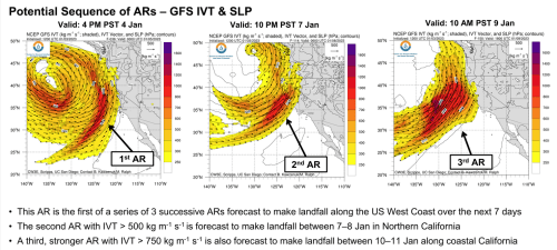 “An atmospheric river in association with a strong low-pressure system over the North Pacific will bring significant precipitation to Northern California between Wednesday morning and Thursday afternoon. IVT associated with this AR will exceed 750 kg m-1 s-1 along the coast of Northern California, making this an AR 3 based on the Ralph et al. 2019 AR Scale. This AR will be the first of three landfalling ARs over the next 7 days, with the following two ARs also forecast to impact Northern and Central California with additional precipitation over the weekend and into early next week. … ” Read more from the Center for Western Weather & Water Extremes here: CW3E AR Update: 3 January 2023 Outlook: Atmospheric River to Bring Significant Rainfall to Northern and Central California
EXPLORE MORE COVERAGE:
- Sacramento Valley, already deluged, braces for more floods, from Cal Matters
- California braces for wide-scale damage from fresh ‘truly brutal’ storm, from The Guardian
- California’s Flood Operations Center activated ahead of atmospheric river storms, from Channel 10
- State water officials ‘cautiously optimistic’ that atmospheric river could improve drought conditions, though it brings new challenges, from SF Gate
- Northern California Storm Watch | Water conservation urged as storm ‘muddies’ water, from Channel 10
- String of brutal atmospheric rivers imperils a California already weakened by drought, from the LA Times
- Massive ‘atmospheric river’ to bring heavy rains, winds, flooding across California, from the LA Times
- Flash flood watch for possible debris flow in Northern California wildfire burn scars, from the Sacramento Bee
- Storms headed for California are being driven by strongest jet stream seen in years. Here’s what it looks like, from the San Francisco Chronicle
- Storms are aimed at Northern California this week and next, forecasts show. What to know, from the San Francisco Chronicle
California snow survey …
Press release: Snow survey shows December storms provided big snow totals with more systems, flooding in forecast
 “The Department of Water Resources (DWR) today conducted the first snow survey of the season at Phillips Station. The manual survey recorded 55.5 inches of snow depth and a snow water equivalent of 17.5 inches, which is 177 percent of average for this location. The snow water equivalent measures the amount of water contained in the snowpack and is a key component of DWR’s water supply forecast. Statewide the snowpack is 174 percent of average for this date. California is expected to see continued rain and snow over the next seven days, with the threat of flooding in parts of California. Conditions so far this season have proven to be strikingly similar to last year when California saw some early rainstorms and strong December snow totals only to have the driest January through March on record. “The significant Sierra snowpack is good news but unfortunately these same storms are bringing flooding to parts of California,” said DWR Director Karla Nemeth. “This is a prime example of the threat of extreme flooding during a prolonged drought as California experiences more swings between wet and dry periods brought on by our changing climate.” ... ” Continue reading this press release from DWR via Maven’s Notebook here: Press release: Snow survey shows December storms provided big snow totals with more systems, flooding in forecast
California snowpack nearly 175% of average but state not out of drought yet
“After several years of drought, California’s snowpack was well above normal on Tuesday, but still, water officials warned that the state is not out of the woods just yet. The good news is that statewide, the snowpack is 174 percent of average for this date and California is expected to see continued rain and snow over the next seven days. Snow surveyors at Phillips Station in El Dorado County recorded 55.5 inches of snow depth and a snow water equivalent of 17.5 inches. … ” Read more from KTVU here: California snowpack nearly 175% of average but state not out of drought yet
SEE ALSO:
- DWR ‘Cautiously Optimistic’ After First 2023 Snow Survey, from Ag Net West
- ‘Our snowpack is actually off to one of its best starts in the past 40 years,’ DWR says, from KRCR
- California snowpack is far above average amid January storms, but a lot more is needed, from the LA Times
- California snow survey finds ‘terrific’ start to season. Why drought concerns persist, from the Sacramento Bee
- California’s snow pack at decade-high for New Year after massive storms, from the San Francisco Chronicle
In other California water news today …
Getting Answers: There are five holes along Cosumnes River, who’s responsible for the fix?
“Day three of trying to get answers for CBS Sacramento viewers continued Tuesday, with more questions left unanswered about levee breaks and two holes on land owned by private farmers along the Cosumnes River. After weekend storms in Sacramento County, CBS Sacramento learned of three confirmed levee breaks, though more are possible, within Reclamation District 800, which encompasses the district and levees that begin at Rancho Murieta in the north along the Cosumnes River and end at Freeman Road. There are no levees south of Freeman Road, however, some landowners have created berms, according to a Sacramento County spokesperson on Tuesday night. Sacramento County directed CBS13 to RD 800 because it was the district’s responsibility to fix breaks within its territory. However, two holes that Sacramento County says are responsible for flooding on Highway 99 and Dillard Road, where one person died, do not fall within the RD 800 territory. Therefore, RD 800 was not responsible for fixes outside of their territory and would not fix the holes along the highway. … ” Continue reading at CBS Sacramento here: Getting Answers: There are five holes along Cosumnes River, who’s responsible for the fix?
Interview: US Rep. Josh Harder on Central California floods, Stockton youth health center
“From the set of storms lashing Northern California to the $1.7 trillion federal budget packed with “big wins” for Stockton and San Joaquin County, Congressman Josh Harder has a lot to say and do as new 9th Congressional District’s representative in Washington. “I think I (now) have a better appreciation for how to actually be effective and how to identify areas of common ground,” Harder said. The third-term congressman — his first term representing Stockton and most of San Joaquin County — touts himself for being able to work with both sides of the aisle to pass legislation. “People are frustrated that they are often overlooked and ignored. We need folks that are going to stand up for our values, and we have a lot of opportunities to do that coming up.” … ” Read more from the Stockton Record here: Interview: US Rep. Josh Harder on Central California floods, Stockton youth health center
How climate change is shaping California’s winter storms
“Drenching rains forecast to pummel California on Wednesday and again over the weekend are poised to be the third and fourth major storms to march through in less than two weeks, raising the prospect of more misery in a season that has already brought flooding, debris flows and power outages to parts of the state. Over the weekend, rescuers scoured rural areas of Sacramento County looking for people trapped in homes or cars. Levees failed near the Cosumnes River and flooded a highway. Winter rain and snow typically provide much of the water used throughout the year in California, which has suffered several years of punishing drought. But when these storms, which are known as atmospheric rivers, are particularly severe or sweep through in rapid succession, they can do more harm than good, delivering too much water, too quickly, for the state’s reservoirs and emergency responders to handle. … ” Read more from the New York Times here: How climate change is shaping California’s winter storms
Fishing groups applaud return of Central Valley restoration funding, urge Secretary Haaland to rescind Trump-era water contracts as well
“Fishing organizations thank Secretary of the Interior Debra Haaland for executing a December 15, 2022 Memorandum that ensures statutory funding to protect fish and wildlife as required under the 1992 Central Valley Project Improvement Act (CVPIA). Secretary’s Haaland’s Memorandum voids the Orwellian declaration by the Trump Administration that restoration of fish and wildlife harmed by the federal Central Valley Project (CVP) was complete and summarily defunded. The action by Secretary Haaland means that CVP water contractors will resume payment for projects to create and improve floodplain and other habitat for salmon, waterfowl, and other fish and wildlife. The payments are required by the CVPIA, passed in 1992 to require the CVP to put fish and wildlife protection on an equal footing with water supply. … ”
How old is that water underground? Why the answer matters in the thirsty West
“It’s not hard to find groundwater. “It’s everywhere,” said Kip Solomon, a geology and geophysics professor at the University of Utah. “There’s no place on earth where you can’t drill a well and hit groundwater.” Groundwater makes up a little more than 30% of the freshwater on earth, while nearly 70% is locked up in glaciers and icecaps. Only a tiny percentage of the planet’s freshwater supply is made up of freely flowing, surface level water. What can be difficult, Solomon said, is finding “water that is of good quality, that’s not too salty. And it’s harder to find water where you can pump out large quantities.” That makes understanding this critical resource all the more important — especially in the drought-stricken West where many communities, from Moab to Cedar City to the Coachella Valley, California, rely on underground aquifers. ... ” Read more from the Salt Lake Tribune here: How old is that water underground? Why the answer matters in the thirsty West
UCSC SciCom students answer complex questions about water
“We asked grad students from UCSC’s Science Communication program to tackle some of the top water questions facing Santa Cruz County. Here’s what they found. Q: How does it work to treat wastewater for human consumption? Can we trust that it’s safe? A: Astronauts drink it. People on fancy yachts drink it. And wastewater experts agree: Recycled toilet water makes good drinking water. Some California communities, like Orange County, already do this. Santa Cruz does not—yet. ... ” Read more from Good Times Santa Cruz here: UCSC SciCom students answer complex questions about water
California leads nation in organic farming
“U.S. farms sold more than $11 billion worth of certified organic commodities in 2021, an increase of 13 percent over the 2019 total of $9.9 billion, according to numbers released by the National Agricultural Statistics Service. And nowhere was that more evident than in California. With $3.6 billion in certified organic commodity sales, California continued to lead the nation, accounting for 32 percent of the nation’s total. … ” Read more from the Turlock Journal here: California leads nation in organic farming
Scientists EEAGER-ly track beavers across Western United States
 “Beavers are among the world’s most effective engineers. Members of this keystone species build dams and canals and, in so doing, create entire, multilayered wetland ecosystems. Beginning in the 1600s, however, the fur trade decimated North American beaver populations. The species began rebounding in the early 20th century but sometimes came into conflict with the agricultural landscape, as by the 1940s and 1950s, people were aggressively modifying streams to maximize yield. Returning to their former haunts meant persecution as beavers flooded crops and felled orchards, explained Alexa Whipple, program director for the Methow Beaver Project (part of a nonprofit called the Methow Salmon Recovery Foundation). Now, humans are starting to recognize that beavers, though still considered pests by some, benefit landscapes in myriad ways. For instance, beaver activity can reduce erosion, create habitat for other species, and maintain wetlands. In fact, we often want beavers to move back into landscapes to do the engineering for us, said Emily Fairfax, an assistant professor at California State University, Channel Islands. … ” Continue reading at EOS here: Scientists EEAGER-ly track beavers across Western United States
In commentary today …
Editorial: Don’t count on a drought-buster
The Santa Rosa Press Democrat editorial board writes, “The storm door is open — at least for now. … Our advice is nothing profound: Don’t add to the challenges already facing first responders. Stay home if you can, but heed evacuation orders. Don’t park near a stream or drive into deep water — just 2 feet can render a car inoperable — and keep a respectful distance from crashing surf. … Finally, as much as we would welcome a return to normal precipitation patterns, don’t count on this storm being a drought-buster. We have been here before. … ” Read the full editorial at the Santa Rosa Press Democrat here: Editorial: Don’t count on a drought-buster
How to save all that water from the ‘atmospheric river’
Andrew Fisher, professor in the Earth & Planetary Sciences Department at UC Santa Cruz, writes, “California has seen so much rain in the last few weeks that farm fields are inundated and normally dry creeks and drainage ditches have become torrents of water racing toward the ocean. At the same time, most of the state is still in severe drought. All that runoff begs the question — why can’t more rainwater be collected and stored for the long, dry spring and summer when it’s needed? As a hydrogeologist, I’m interested in what can be done to collect runoff from storms like this on a large scale. There are two primary sources for large-scale water storage that could help make a dent in the drought: storing it behind dams and in the ground. … ” Continue reading at the LA Times here: How to save all that water from the ‘atmospheric river’
In regional water news and commentary today …
SACRAMENTO VALLEY
Lake Shasta 34% full could see water level rise way up
“While all the rain that fell in December helped raise the level of a parched-looking Lake Shasta, the series of winter storms failed to generate the massive inflows of water into the state’s largest reservoir. That’s expected to change over the next 10 days as a series of wet storms moves through the region, dropping several inches of rain, which has prompted the National Weather Service to issue a flood watch for Wednesday and Thursday in Shasta County. … ” Read more from the Redding Record-Searchlight here: California storms: Lake Shasta 34% full could see water level rise way up
What is a levee and how are floods caused by levee failures?
“A storm that started on New Year’s Eve and continued into the day after caused flooding near the Cosumnes River leading to road closers, including Highway 99 in Sacramento County. At the time, Sacramento County officials confirmed to FOX40 News that it was at least three levees that were breached, which caused the flooding. Sacramento County officials then proclaimed a “local state of emergency for winter storms,” due to the roadway impacts, rising creek and river levels, and flooding in Wilton, which is about 15 minutes east of Elk Grove. … ” Read more from Fox 40 here: What is a levee and how are floods caused by levee failures?
Evacuation the ‘only option’ for Sacramento County communities near still-rising rivers
“With more storms barreling toward Northern California, south Sacramento County communities near the Cosumnes and Mokelumne rivers are on edge for new flood evacuations this week. Point Pleasant residents were ordered to evacuate on Sunday and Wilton residents were told to remain prepared to evacuate if they haven’t already even as reclamation district officials raced around the clock to shore up levee breaks ahead of the storm system expected to arrive Wednesday. “We’re very concerned,” said Mark Hite, a trustee on the reclamation district that manages Cosumnes River levees in the area. “One of the somewhat benefits of this river. It comes up fast, but in the past, it also goes down fast. Hopefully, we can get a couple of days of dry weather and lose a couple of feet of flow.” … ” Read more from the Sacramento Bee here: Evacuation the ‘only option’ for Sacramento County communities near still-rising rivers
Yuba Water Agency increases state application funds for TRLIA
“During a board meeting on Tuesday, the Yuba Water Agency Board of Directors approved a $1 million increase in its fund commitment as a local match for Three Rivers Levee Improvement Authority (TRLIA). This will allow TRLIA to apply for state and federal funds for additional flood risk reduction in south Yuba County. These funds were allocated to expand levee work in south Yuba County, including the Climate Resiliency project and the Goldfields Multi-Benefit Project, according to an agency staff report. … ” Read more from the Appeal-Democrat here: Yuba Water Agency increases state application funds for TRLIA
NAPA/SONOMA
‘Prepare now for flooding along the Russian River,’ weather service says
“California’s Russian River is expected to spill over its banks in Sonoma and Mendocino counties amid a potent rain and wind event, officials said Tuesday night. The National Weather Service warned residents of riverside towns such as Guerneville and Hopland to prepare for flooding along roadways and at homes and businesses on Thursday and Friday. The warning comes in an area of the Golden State that was already drenched in a historic New Year’s Eve atmospheric river event. The next storm system is expected to arrive Wednesday morning and dump rain and kick up powerful winds into Thursday morning. Forecasters are referring to the system as a bomb cyclone, as it’s forming rapidly off the coast. They warn that impacts across Northern California will include flooding, power outages, downed trees and potentially even loss of life. … ” Read more from SF Gate here: ‘Prepare now for flooding along the Russian River,’ weather service says
SEE ALSO: Russian River expected to exceed flood stage amid torrential new rainstorm, from the Santa Rosa Press Democrat
BAY AREA
Rapidly intensifying ‘bomb cyclone’ to fuel extreme weather in the Bay Area. These areas are most at risk
“The last day of 2022 ended with one of the wettest 24 hours in San Francisco’s recorded history. A strong winter storm, fueled by rich moisture off a pineapple express, hosed the city with nearly 5.5 inches of rain and caused widespread flooding across the Bay Area and large swaths of Northern California. Now, another winter storm is forming off the coast. This rapidly intensifying system, known as a bomb cyclone, is set to ramp up another round of strong winds, heavy rainfall and snow squalls on the Golden State over the next couple of days. … ” Read more from the San Francisco Chronicle here (gift article): Rapidly intensifying ‘bomb cyclone’ to fuel extreme weather in the Bay Area. These areas are most at risk
SEE ALSO: Bay Area flood risk: This detailed map shows danger zones, from the SF Chronicle
Bay Area reels from storm damage as it braces for ‘brutal’ atmospheric river
“Along the narrow river that separates San Mateo and Santa Clara Counties — south of the city along the peninsula — residents braced themselves for the incoming storm, still reeling from Saturday’s deluge. On New Year’s Eve, the typically dry creek swelled over its banks, flooding patios, streets, parking lots and stores throughout East Palo Alto, Palo Alto and Menlo Park — including the entrance of Menlo Atherton High School’s Performing Arts Center. At the Chaucer-Pope Bridge, a small, two-lane bridge connecting Menlo Park and Palo Alto, water rose to levels just inches shy of its 24-foot capacity. The volume of water moving through the creek on Stanford University’s property — at 7,420 cubic feet per second — exceeded the 1998 record of 7,200. … ” Read more from the LA Times here: Bay Area reels from storm damage as it braces for ‘brutal’ atmospheric river
San Jose proclaims state of emergency ahead of major storm system
“With another punishing storm system on its doorstep, the city of San Jose on Tuesday night proclaimed a state of emergency and issued a mandatory evacuation order for unhoused residents who live near the metropolis’ largest waterways. Signed by City Manager Jennifer Maguire, the proclamation gives the city the emergency powers it needs to respond to storm events, according to a city news release. “San Jose is taking this extra precautionary step during this storm surge to protect our residents, particularly our most vulnerable unhoused neighbors,” Mayor Matt Mahan said in the release. “We want to make sure all residents are informed and prepared to stay safe, and that city staff has the ability to move quickly to relocate encampments that are in harm’s way.” … ” Read more from the San Jose Mercury News here: San Jose proclaims state of emergency ahead of major storm system
Ca DWR releases water from Del Valle Dam, as new storm approaches
“With a another storm on the way later this week, record rainfall totals from a storm that hit the area New Year’s Eve caused numerous roads to close due to mudslides and flooding, officials said. In Livermore where nearly 2 inches of rain were recorded in a 24 hour period, police were asking residents on Sunday to stay away from Arroyo Mocho creek and trail as the California Department of Water Resources released water from the Del Valle Dam at a rate of 500 cubic feet per second. State officials said the dam was not at risk Sunday. ... ” Read more from The Patch here: Ca DWR releases water from Del Valle Dam, as new storm approaches
CENTRAL COAST
Flooding causes widespread damage in Watsonville, countywide
“Santa Cruz County is considering making a disaster declaration in the wake of the massive rainstorm that brought flooding to several parts of the county, according to Santa Cruz County spokesman Jason Hoppin. The County is still waiting on responses from State and federal officials. “Yesterday outperformed all expectations,” he said. “Everybody predicted this was going to be a normal winter storm.” Crews on Sunday morning were assessing the damage to 43 roads in the unincorporated parts of the County that were impacted by the rains. This includes a sinkhole that formed on Glen Haven Road, and a culvert that collapsed on China Grade. … ” Read more from the Pajaronian here: Flooding causes widespread damage in Watsonville, countywide
Flood warning issued for Salinas
“A storm is expected to hit the Salinas Valley this week that could cause flooding, downed trees, and power outages. The atmospheric river is forecasted to bring wind gusts of more than 50 mph in some areas and heavy rains. Central coast residents were warned by the National Weather Service not to “let your guard down.” “…it is worth noting that this system is different than the previous storm to impact the region, yet impacts will still be significant,” National Weather Service officials stated in Wednesday’s local forecast discussion. City officials are also asking residents to be prepared. … ” Read more from the Californian here: Flood warning issued for Salinas
City of Paso Robles to resume water shutoffs for non-payment in February
“Paso Robles will officially restart the policy of shutting water service off due to non-payment in February. Existing accounts with past due balances over 60 or more days will be subject to water shutoffs. The city cites fewer COVID-19 cases and multiple available payment options in making this announcement. … ” Read more from KEYT here: City of Paso Robles to resume water shutoffs for non-payment in February
There will be (bad) blood over Toro Creek oil spill
“First responders in Santa Barbara County celebrated New Year’s Day by working to contain an oil spill oozing from an abandoned open-pit oil-mining operation dating back to the 19th century up Toro Creek high in the foothills overlooking Montecito and Summerland. This year’s drenching winter rains appear to have overwhelmed the carrying capacity of an improvised pipeline and catch-basin created 25 years ago to keep the oil from dribbling out of that unpluggable pit — at a rate of 30 gallons a day — and creeping into the nearby creek and washing downstream with the rushing rains. As of this writing, it remains uncertain just how much oil got into the creek. But reportedly none has been observed south of Highway 192 along Toro Canyon Road. … ” Read more from the Santa Barbara Independent here: There will be (bad) blood over Toro Creek oil spill
SAN JOAQUIN VALLEY
Manteca fails to reduce water use during 2022
“The numbers show that the City of Manteca’s enforcement of its emergency drought water use rules is a dismal failure. The anecdotal evidence — commercial areas irrigating lawns in the middle of steady rain along with a liberal sprinkling of homeowners doing the same — shows widespread ignorance and/or flaunting of the rules. And state water experts warn despite up to three inches of rain expected to fall today and Thursday in the South County with lighter rain daily through Sunday, California is so deep into drought that Mother Nature is far from breaking the drought’s back. … ” Read more from the Manteca Bulletin here: Manteca fails to reduce water use during 2022
First snow survey of season shows Kings River snowpack is above average
“The Department of Water Resources’ first snow survey at Phillips Station near Lake Tahoe was encouraging. It showed the snowpack at 174% of average. “Our snowpack is actually off to one of our best starts in the past 40 years but that does not mean we are out of the woods quite yet,” said Sean de Guzman, manager of DWR’s snow surveys. This survey though does not tell the central valley story. “What happens at Echo Summit is really important for the people in Sacramento and Stockton but it doesn’t mean a thing to us,” said Randy McFarland with the Kings River Water Association. … ” Read more from KFSN here: First snow survey of season shows Kings River snowpack is above average
Conditions “significantly improved” for Kern River watershed
“Water watcher Scott Williams put out his Kern River Snow and Water Report on Monday and, based on national, statewide and local data, things have gone from “eh…” to fairly promising. Precipitation in the upper Kern basin, which feeds the North Fork of the Kern river was 134% of average for the water year to date. And on the South Fork of the Kern River, precipitation was 116% of average. “Observed water year to date Kern River basin flow is 60% of average,” the report states. … ” Read more from SJV Water here: Conditions “significantly improved” for Kern River watershed
EASTERN SIERRA
Indian Wells Valley Groundwater Authority secures Infrastructure Project Assistance in Water Resources Bill
“Through the recently passed Water Resources Development Act of 2022, the Indian Wells Valley Groundwater Authority (“Authority”) will receive additional planning assistance on infrastructure projects required to implement the Groundwater Sustainability Plan (GSP). Under the legislation, the United States Army Corps of Engineers (“USACE”) will assist the Authority by providing validation studies, land resource identification and other activities primarily associated with the Authority’s imported water interconnection project. In addition to the assistance provided in the Water Resources bill, in January the Authority will consider submitting a Letter of Intent requesting further involvement by USACE in all GSP-related projects through its Planning Assistance to States program. … ” Read more from the Ridgecrest Independent here: Indian Wells Valley Groundwater Authority secures Infrastructure Project Assistance in Water Resources Bill
SOUTHERN CALIFORNIA
Strong storm moves into Southern California, raising flooding fears
“A powerful storm was bearing down on Southern California Wednesday, again raising fears of flooding and debris flows in recent burn areas. Rain will start lightly Wednesday morning with precipitation ranging from one-tenth to a quarter-inch per hour in some areas, according to the National Weather Service. But by Wednesday afternoon, the rain will increase steadily, with downpours continuing into Thursday and reaching an inch per hour in some locations. The “peak intensity” of the storm is expected to be Thursday morning. NWS forecasters said 2 to 4 inches of rain could fall across most of the area, with some mountain areas receiving 4 to 8 inches. … ” Read more from the OC Register here: Strong storm moves into Southern California, raising flooding fears
Along the Colorado River …
Why can’t the West just pipe in water from the Mississippi or Missouri rivers to save the Colorado River?
 “Engineers and water experts knew for decades that growth in the Colorado River Basin would eventually hit a tipping point. That is, unless the states depending on the river found a new source of water. One way to do that, civil engineer Royce J. Tipton wrote in 1965, would be to pipe water in from somewhere else, also referred to as “importing” water. One scheme considered in the 50s and 60s (but never developed), the North American Water and Power Alliance, proposed to pipe water from rivers in Alaska and Canada south into the Colorado River’s headwaters, among other places. Water transfers like this are already in use across the world and have been for millennia (think of the Roman aqueducts). An example in the Colorado River Basin would be the Central Arizona Project, a canal system transporting river water across hundreds of miles of desert and into the heart of Arizona for cities like Phoenix and Tucson. These canals and pipelines are expensive to build, though, and take years. … ” Continue reading at the San Jose Mercury News here: Why can’t the West just pipe in water from the Mississippi or Missouri rivers to save the Colorado River? | Read via the Denver Post
Could desalinated ocean water be used to fix the dwindling Colorado River?
“Desalination plants are already in use all over the world, drawing in ocean water and filtering out its dangerously high salt content, bacteria and other impurities to make it safe for use. A dozen are in use in California, alongside more in Arizona, Mexico and other areas dotting North America. One in Australia, the Victorian Desalination Plant, can provide up to a third of Melbourne’s water supply, according to the city’s water provider. And Israel is being hailed as a leader in the field with five desalination plants along its coasts providing tap water for nearly 9.2 million people. But there are quite a few catches to the strategy. … ” Read more from the San Jose Mercury News here: Could desalinated ocean water be used to fix the dwindling Colorado River?
Arizona prepares to test hundreds of drinking water systems for toxic ‘forever chemicals’
“The Arizona Department of Environmental Quality has initiated a statewide effort to sample over 1,200 public water systems across the state for 29 different kinds of a hazardous chemical known as PFAS. The goal is to produce a detailed map showing the presence of PFAS in drinking water supplies, the first step toward cleaning up contaminated water sources. Mapping the presence of these contaminants in Arizona wells is a crucial first step, especially as many communities grow more reliant on groundwater amid cuts from Colorado River water. … ” Read more from Arizona Central here: Arizona prepares to test hundreds of drinking water systems for toxic ‘forever chemicals’
Rio Verde Foothills getting creative after losing water source
“One Valley community is adjusting to a new reality now that they are without access to a familiar water source. “Really concerned and worried. In fact, I’m happy I have a pool because every time it rains at least I can siphon that,” says Dee Thomas, Rio Verde Foothills resident. Just days into the new year, residents in the Rio Verde Foothills community are getting creative with how they conserve and use water. “We use it mostly for showering. For, you know, washing clothes, the bathroom,” says Thomas. … ” Read more from Channel 15 here: Rio Verde Foothills getting creative after losing water source
Commentary: A new model could reveal major water trouble for Buckeye. Release it now
Kathleen Ferris, former director of the Arizona Department of Water Resources and a senior research fellow at ASU’s Kyl Center for Water Policy, writes, “In the far west side of the Valley of the Sun – flanking what opponents once dubbed the “road to nowhere” – the City of Buckeye has approved 27 master planned communities and two planning areas that would grow Buckeye’s population by 872,000 people. Nearly all this development would be located on pristine desert land without a history of water use. And if developers get their way and are allowed to move forward, the massive new growth they’re proposing would seriously threaten the entire region’s groundwater. Not only is our groundwater finite and rapidly decreasing, but warning signs from new groundwater models indicate that there is not enough of it to meet the needs of the prospective homeowners in these developments indefinitely. … ” Read more from Arizona Central here: A new model could reveal major water trouble for Buckeye. Release it now
Press release: U.S. urged to deny huge Arizona pump storage projects targeting Black Mesa
“Tó Nizhóní Ání, Diné Citizens Against Ruining our Environment and the Center for Biological Diversity have filed motions urging the Federal Energy Regulatory Commission to deny preliminary permit applications for three pump storage projects southeast of Kayenta on the Navajo Nation. “These wildly unrealistic projects would only add to decades of harm from coal mining to Black Mesa’s people, land and aquifers,” said Nicole Horseherder, executive director of Tó Nizhóní Ání. “Asking for federal approvals before the consent of Black Mesa’s communities is the height of arrogance. It tells us all we need to know.” … ” Read more from the Center for Biological Diversity here: U.S. urged to deny huge Arizona pump storage projects targeting Black Mesa
Snowpack at 142% after week of storms in Upper Colorado River Basin
“Snowpack levels crucial to water supplies in the Colorado River basin have been rising over the past week as storms hit the Rocky Mountains. Dec. 27 measurements of 102% snowpack in the region — just above normal — had risen to 142% as of today (Jan. 3) in the Upper Colorado River Basin. That week-to-week change is good news but demonstrates the volatility of snowpack levels. Just as rainfall makes little to no impact on the level of Lake Mead, snowpack levels in early January shouldn’t be seen as a sign that a few snowstorms will erase years of drought, experts say. … ” Read more from Channel 8 here: Snowpack at 142% after week of storms in Upper Colorado River Basin
In national water news today …
Can EPA’s Clean Water Act rule survive the courts?
 “Durable protections. That’s the phrase Biden administration officials have used for the past two years to describe what they hope to achieve in rewriting the rules governing which wetlands and waterways are regulated by the Clean Water Act. Now, they say, they have achieved that goal with a final regulation released last week. “I believe that this is a very durable rule,” EPA water chief Radhika Fox told E&E News in an interview, saying the regulation “balances the needs for clean water protections with the needs of all water users.” Water wonks aren’t so sure. The question of what is a “water of the U.S.,” or WOTUS, has been the subject of fierce debate and litigation ever since Congress passed the Clean Water Act in 1972. Wading into the controversy and writing a regulation that could withstand legal challenges would be a tall order at any time, but especially now as the Supreme Court is already weighing questions of federal jurisdiction. “There will be a court challenge, there always is,” said Mark Ryan, a former Clean Water Act attorney for EPA Region 10. “The upcoming Sackett decision will tell us how durable it is. Or not.” … ” Read more from E&E News here: Can EPA’s Clean Water Act rule survive the courts?
Report details how much average wastewater service costs have increased
“The National Association of Clean Water Agencies (NACWA) recently released a new report showing that average annual wastewater service costs for American families increased at twice the rate of inflation between 2000 and 2021. The report highlights how income inequality is driving heightened affordability challenges for low-income households in every corner of the United States, and that federal investments in water infrastructure, which has been on the decline for decades, are currently insufficient to cover the rising cost of water services. The report, titled “The Growing U.S. Water Affordability Challenge and the Need for Federal Low-Income Water Customer Assistance Funding,” notes that increased federal investment would remove this burden from Americans living at or beneath the poverty level. ... ” Read more from Water Finance & Management here: Report details how much average wastewater service costs have increased
Scientists say planet in midst of sixth mass extinction, Earth’s wildlife running out of places to live
“In what year will the human population grow too large for the Earth to sustain? The answer is about 1970, according to research by the World Wildlife Fund. In 1970, the planet’s 3 and a half billion people were sustainable. But on this New Year’s Day, the population is 8 billion. Today, wild plants and animals are running out of places to live. The scientists you’re about to meet say the Earth is suffering a crisis of mass extinction on a scale unseen since the dinosaurs. We’re going to show you a possible solution, but first, have a look at how humanity is already suffering from the vanishing wild. … ” Read more from CBS News here: Scientists say planet in midst of sixth mass extinction, Earth’s wildlife running out of places to live

