
On the calendar today …
- WORKSHOP: CII Water Conservation from 9am to 12pm. As we plan for continued extreme drought and a 4th dry year, the Department of Water Resources (DWR) is hosting a public workshop to get input from water use efficiency leaders in commercial, industrial, and institutional (CII) on four key strategies for improving water conservation. The workshop will help inform the development of proposed DWR direct install programs for turf conversion/replacement and indoor fixture retrofits. Click here to register.
- MEETING: State Water Resources Control Board beginning at 9:30am. Agenda items include consideration of a proposed Resolution to adopt the Draft Proposition 68 Groundwater – Drinking Water Treatment Operations and Maintenance Funding Program Guidelines; consideration of proposed Order prepared by the Administrative Hearings Office (AHO) on San Joaquin County’s Application 29657 for a permit to appropriate water from the South Fork American River at the Freeport Regional Water Facility on the Sacramento River in Sacramento County; and a report on the Wastewater Arrearages Program. Click here for the full agenda and remote access instructions.
In California water news today …
California is feeling optimistic it’s winning the war on giant, destructive swamp rodents
 “California may be winning its five-year, $13 million battle with nutria — the 20-pound, orange-toothed swamp rodents that biologists once feared would play hell with wetlands, flood-control levees and the state’s water-delivery system. “We do absolutely feel like everything is trending in the right direction,” said Valerie Cook, who runs the Department of Fish and Wildlife’s nutria eradication program. Cook said her team is seeing nutria numbers declining, and they’ve managed to keep them out of the Sacramento-San Joaquin Delta, California’s most important waterway. … ” Read more from the Sacramento Bee here: California is feeling optimistic it’s winning the war on giant, destructive swamp rodents
Karen Ross on water management restructuring
“California Secretary of Agriculture Karen Ross joined us in Sacramento at the Agri-Pulse Food and Ag Issues Summit West to talk all things agriculture. Ross says water supply reliability in California starts with a state-wide infrastructure update. That includes updating modeling and forecasting, storm water capture, and water recycling. “What took us by surprise last year is that our modeling is based on historic data, and that’s great except that we don’t have the same kinds of circumstances that we’ve had. So one, how do we do better forecasting? … ” Read more from Ag Info here: Karen Ross on water management restructuring
One way out of a drought? Technology that makes water potable.
“Santa Monica, California, used to rely heavily on water imported from the northern part of the state. But now less than half the coastal city’s water is imported, which spared the community from the state’s mandatory outdoor water restrictions that began at the beginning of June. “That doesn’t mean we’re just sitting around doing nothing,” said Santa Monica’s water resources manager, Sunny Wang. “We’re looking at increasing our conservation efforts.” Standing at a water treatment plant a block from the ocean, Wang said the plant can process half a million gallons of water runoff every day. But since rain is a little sparse these days, Wang said, the city decided to start using saltwater. … ” Read more from Marketplace here: One way out of a drought? Technology that makes water potable
Water resources to become less predictable with climate change
“Water resources will fluctuate increasingly and become more and more difficult to predict in snow-dominated regions across the Northern Hemisphere by later this century, according to a comprehensive new climate change study led by the National Center for Atmospheric Research (NCAR). The research team found that, even in regions that keep receiving about the same amount of precipitation, streamflow will become more variable and unpredictable. As snowpack recedes in a warmer future and fails to provide reliable runoff, the amount and timing of water resources will become increasingly reliant on periodic episodes of rain. “Water managers will be at the whim of individual precipitation events instead of having four-to-six months lead time to anticipate snowmelt and runoff,” said NCAR scientist Will Wieder, the lead author. “Water management systems in snow-dominated regions are based on the predictability of snowpack and runoff, and much of that predictability could go away with climate change.” … ” Read more from NCAR here: Water resources to become less predictable with climate change
SEE ALSO: This is how climate change will affect the availability of snow, water, from ABC News via MSN
California’s drought: Geology researchers investigate how mega dry spells spark urban wildfires
“To better understand the impacts of drought and wildfire activity in an urban landscape, Cal State Fullerton geology researchers are developing the first-ever study to reconstruct the fire history for Chino Hills State Park. With California experiencing prolonged dry conditions for the third consecutive year, the parched, hot and windy weather, combined with dried out and flammable vegetation, increases the probability of large-scale wildfires, said paleoclimatologist Matthew E. Kirby. The Chino Hills park — set in an urban environment where people live next to open, dry and flammable undeveloped areas — has experienced two major fires in recent times: the Blue Ridge Fire in 2020 and the Freeway Complex Fire in 2008. The park and surrounding area has over 100 years of fire history. … ” Read more from CSU Fullerton here: California’s Drought: Geology Researchers Investigate How Mega Dry Spells Spark Urban Wildfires
These maps show how alarmingly fast California is losing trees as climate warms
“California’s forests are in rapid retreat, which bodes ill for the future. Using satellite data, researchers from the University of California, Irvine found that trees in the state’s mountainous regions declined 6.7 percent between 1985 and 2021 thanks to wildfires, drought and other climate-related sources of stress. The drop was even steeper in the Sierra Nevada, which suffered 8.8% tree cover loss during that time period. Forests play a critical role in mitigating climate change by capturing and storing carbon dioxide from the atmosphere, so the new research — published in the journal AGU Advances — raises fresh concerns about California’s environmental future. … ” Read more from the San Francisco Chronicle here: These maps show how alarmingly fast California is losing trees as climate warms
As wildfire threats grow, there’s a booming business in defensible space
“In a community situated on the Peavine Mountain foothills in Reno, a work crew revved up brush-clearing tools. These weren’t your average Joe’s weed whackers; these were high-powered trimmers that sent leaves and branches flying everywhere. The crew was with Wilderness Forestry, a Reno-based company hired by homeowners, homeowners associations, and commercial properties to reduce wildfire threats. Its job is to create what’s known as “defensible space” – a buffer between a property and the flammable brush and vegetation surrounding it. “A lot of times when the developers build the homes, you know, they build them right on top of each other. And there’s not a whole lot of space in between them,” said Bill Steward, Wilderness Forestry’s defensible space inspector. Steward said that’s one reason for the need to mitigate the risks of a wildfire ripping through neighborhoods – a threat that has heightened in the drought-stricken region. … ” Read more from KUNR here: As wildfire threats grow, defensible space business booms
Calif.’s last nuclear plant faces closure. Can it survive?
 “California political leaders are debating whether to keep the state’s final nuclear power plant open beyond 2025, a decision with repercussions for the state’s emissions, electricity mix and ability to prevent blackouts amid high demand in the years ahead. But saving the Diablo Canyon Power Plant — near the Pacific Ocean in San Luis Obispo County — would require clearing numerous hurdles within just a few years. The plant is scheduled to shutter one unit in 2024 and the second in 2025. The closures are part of a settlement agreement reached by plant operator Pacific Gas and Electric Co., environmental groups and local authorities. Unwinding that agreement — even to keep the plant open a few more years — would require approval from the California Legislature and four state agencies. The U.S. Nuclear Regulatory Commission would need to issue an operating license renewal. And the plant would need to undergo safety upgrades, state officials have said. … ” Read more from E&E News here: Calif.’s last nuclear plant faces closure. Can it survive?
Storing carbon a mile and a half beneath Stanislaus County could help save the planet
“A company seeks to drill two very deep wells in Stanislaus County to capture some of the carbon dioxide involved in climate change. Aemetis Inc. would sink the wells at its ethanol plant in Keyes and another coming soon to Riverbank. They would be perhaps 8,000 feet deep, far below groundwater sources, and would store close to 40 million tons of compressed gas over 20 years. The $250 million project would put the county at the forefront of the effort to sequester CO2 that otherwise would trap heat in the atmosphere. Experts say climate change is already disrupting agriculture, raising sea levels and making storms and wildfires more extreme. … ” Read more from the Modesto Bee here: Storing carbon a mile and a half beneath Stanislaus County could help save the planet
In commentary today …
On the Public Record: Abundance progressivism
On the Public Record writes, “I saw this description of Abundance Progressivism with great relief. I was delighted for a name for my position. It also explained to me why I’ve been irritated with the “tear out your lawn” school of water conservation in this drought. … Over the past few years, I have increasingly come to the position that we must create the improved next climate world before we eliminate the things we can no longer sustain. This is based on a few things ... ” Read more from On the Public Record here: On the Public Record: Abundance progressivism
The eye of the storm and the State Water Resources Control Board
Deirdre Des Jardins writes, “The State Water Resources Control Board’s Climate Change Mitigation Strategist, Max Gomberg, just retired, and sent an incendiary parting letter to his colleagues, stating, ‘Witnessing the agency’s ability to tackle big challenges nearly eviscerated by this Administration has been gut wrenching. The way some of you have simply rolled over and accepted this has also been difficult to watch.’ One of the things I came to understand in our campaign last year to save the Delta Independent Science Board was that California water is like hurricane, and the Delta Independent Science Board and regulatory agencies such as the State Water Resources Control Board need to operate in the eye of the storm. … ” Read more from the California Water Research blog here: The eye of the storm and the State Water Resources Control Board
What about desal?
The California Water Impact Network (C-WIN) writes, “Modern desalination technology employs one of two approaches: multi-stage flash distillation or reverse osmosis. Flash distillation uses heat to evaporate seawater; the vapor, free from salt and other impurities, is then recondensed. Reverse osmosis removes water from salt through temperature differentials across a special membrane. Most modern desalination plants employ reverse osmosis.Desalination can’t scale sufficiently to meet the needs of a state with 40 million people and a diverse economy that ranges from agriculture to high technology. … ” Read more from C-WIN here: What about desal?
Op-Ed: Face it, Yosemite lovers — sprinklers can’t save the Mariposa Grove forever
Char Miller, a professor of environmental history at Pomona College, writes, “Californians are shutting off their irrigation systems to reduce water consumption amid a devastating, climate-driven drought. In Yosemite National Park, sprinklers were turned on in hopes of slowing the climate-driven Washburn fire from threatening the Mariposa Grove of giant sequoias. The differences are instructive. Embracing brown lawns is a proactive commitment to a more climate-resilient landscape. The Mariposa sprinklers, deployed to protect such iconic trees as the Grizzly Giant, are a denial of the climate realities that have made the Sierra increasingly vulnerable to wildfire. The same kind of denial is evident in two problematic ideas that frame the concerted effort to stop the Washburn blaze — preservationism and fire suppression. … ” Read more from the LA Times here: Op-Ed: Face it, Yosemite lovers — sprinklers can’t save the Mariposa Grove forever
What will happen if Lake Mead dries up? Look to the Salton Sea.
Richard Thomas, retired business owner and author, writes, “Lake Mead’s water level continues to fall to historic lows, bringing the reservoir less than 150 feet away from “dead pool” — so low that water cannot flow downstream from the dam. The loss of water entirely from this source would be catastrophic. Eliminating the hydroelectric power source that supplies 29 million people in the Southwest with a portion of their electricity would only compound the problem. Such an event would have an enormous impact on San Diego County where half of the region’s total water supply relies on the Colorado River. … Think it could never happen? It already has on a smaller scale. … ” Read more from the San Diego Union-Tribune here: What will happen if Lake Mead dries up? Look to the Salton Sea.
There’s a crisis on the Colorado River
Dan Keppen, executive director of the Family Farm Alliance, writes, “The Bureau of Reclamation in June issued a call to the public for assistance in developing future long-term operating provisions on the Colorado River. This announcement came within days of Reclamation Commissioner Camille Touton’s message to a Senate committee that the seven states of the Colorado River Basin must come up with an emergency deal by mid-August to conserve between 2 and 4 million acre-feet of water in the next year in order to protect the entire river system. … Farmers and ranchers throughout the Basin also believe that urban interests served by the Colorado River – many of them who rely on water exported out of the Basin – must share the pain. “If farmland doesn’t get water, city lawns shouldn’t get water” is a common refrain. The full spectrum of impacts – not just direct impacts, but also impacts to national security, food supply, rural communities, the Salton Sea, and third-party stakeholders – must be assessed. Agriculture cannot be decimated by these short-term measures. … ” Read more from the Western Farm Press here: There’s a crisis on the Colorado River
Today’s featured article …
FIVE QUESTIONS: Jon Rosenfield, Senior Scientist at the Baykeeper and longtime Delta scientist
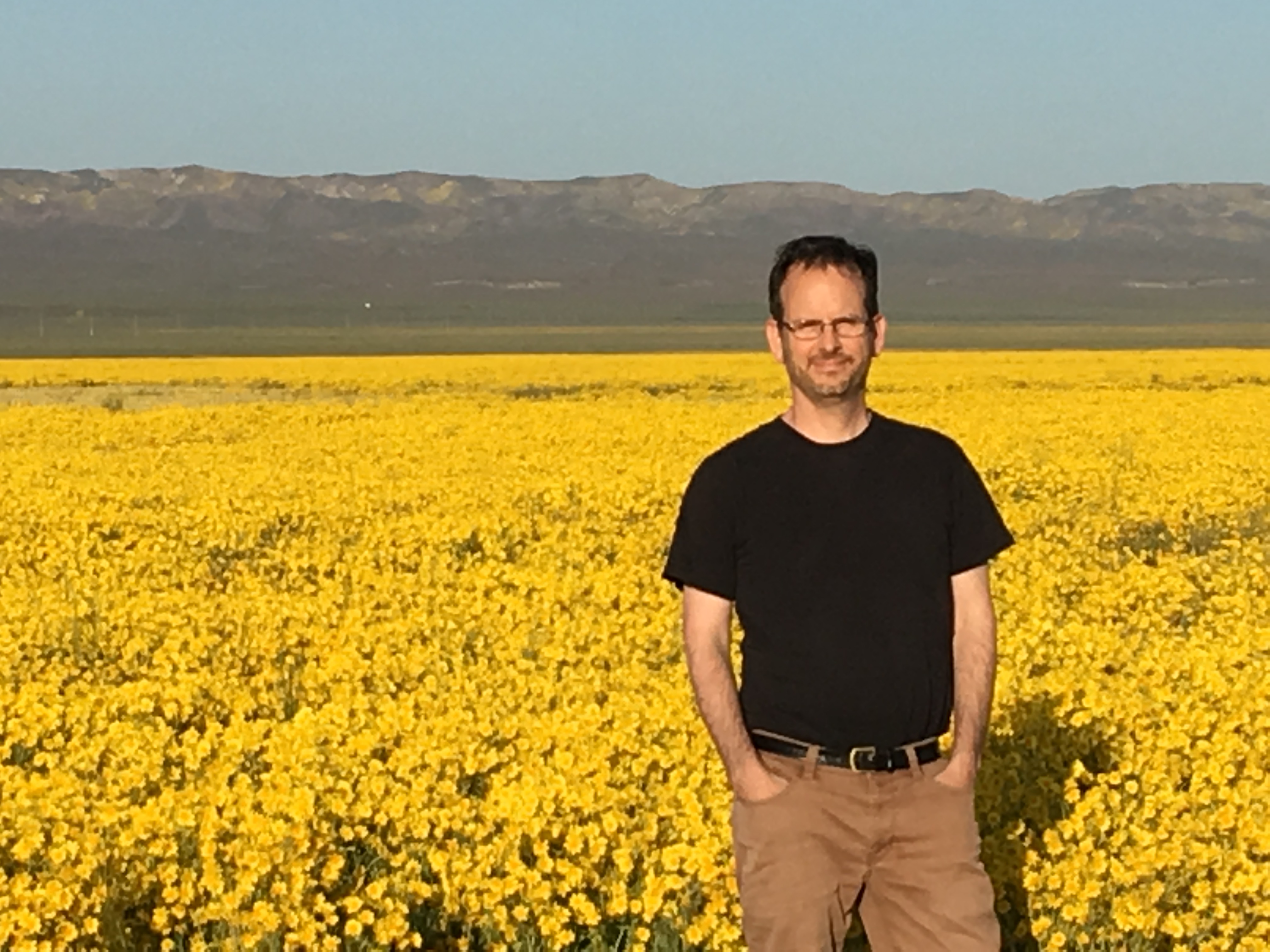 After completing degrees from Cornell University, University of Michigan, and the University of New Mexico, Dr. Jon Rosenfield returned to the Bay Area in 2002, where he worked as a postdoctoral researcher in the laboratory of Dr. Peter Moyle. He researches and is a tireless advocate for the Central Valley’s native salmon, steelhead, and smelt species. Dr. Rosenfield went on to The Bay Institute where he worked for over ten years to protect fisheries, becoming one of the region’s leading experts on the importance of freshwater flows from the Delta for the sustainability of the Bay’s ecosystem and fish populations. He is now a Senior Scientist at San Francisco Baykeeper, a position he has held since 2019. I asked him questions about the Delta Conveyance Project, the Voluntary Agreements, and what he is working on at the Baykeeper.
In regional water news and commentary today …
NORTH COAST
Water battle in drought-plagued wildlife refuges ends in draw
“A federal appeals court on Monday upheld a 15-year plan for several drought-stricken wildlife refuges along the Oregon and California border against challenges by agribusiness and conservation groups alike. The three decisions by the 9th U.S. Circuit Court of Appeals mark a stalemate in a century-old water war in the Klamath Basin, where a federal irrigation project to support farming began in 1906 and the nation’s first wildlife refuge was established in 1908. The U.S. Fish and Wildlife Service’s 2017 Comprehensive Conservation Plan drew fire from agribusiness for regulating farming practices in the Klamath Basin National Wildlife Refuge Complex, while conservationists argued the restrictions did not go far enough. … ” Read more from Reuters here: Water battle in drought-plagued wildlife refuges ends in draw
MOUNTAIN COUNTIES
Tahoe Conservancy’s marsh restoration making progress
“The California Tahoe Conservancy is nearing completion of the second stage of a project to restore the Upper Truckee Marsh, which is just a piece of the plan the state agency has been working on the last 20 years to bring the marsh back to its former glory. The Upper Truckee Marsh sits just east of Tahoe Keys and north of Highway 50, where the Upper Truckee River meets Lake Tahoe on the south shore. An aerial photo of the marsh from the 1940s shows a very different marsh than the one that’s there today. The Upper Truckee River split into multiple channels and lagoons and the water flowed through the 1,600 acres of marsh before entering Lake Tahoe. … ” Read more from the Mountain Democrat here: Tahoe Conservancy’s marsh restoration making progress
It’s not your imagination, Lake Tahoe has seen higher than average wind speeds this spring and summer
“If you’ve been thinking this spring and so far this summer has been windier than normal, you’re right! Between April 1 and June 30 this year, the average wind speed at the Tahoe Valley Airport has been 7.60 miles per hour (factoring in 24 hours a day and non-wind days). This is the highest average for this period since 2000 when that average was 8.30 miles per hour. The wind is caused when gases move from high-pressure areas to low-pressure areas. And the bigger the difference between the pressures, the faster the air will move from the high to the low pressure. That rush of air is the wind we experience. ... ” Read more from South Tahoe Now here: It’s not your imagination, Lake Tahoe has seen higher than average wind speeds this spring and summer
No harmful algal blooms at Lake Tahoe but public should be aware
“While there may be algae “caution” signs at two South Lake Tahoe beaches, the Lahontan Water Board says they are only to bring awareness and no harmful algae blooms (HABs) have been detected there, or at any water area in the Lake Tahoe Basin. Kiva Beach and Connelly Beach both have the signage, and there is some visual appearance of algae blooms in those areas, so Lahontan posts the signs due to the high level of recreation that occurs at these beaches. Staff with Lahontan samples locations around Lake Tahoe and the Sierra prior to Memorial Day, the 4th of July, and Labor Day, then if any blooms are reported they will sample those areas as soon as possible according to Sabrina Rice, environmental scientist with the Lahontan Regional Water Quality Control Board. Rice is responsible for the HAB program in the area. … ” Read more from South Tahoe Now here: No harmful algal blooms at Lake Tahoe but public should be aware
Floating the Wild and Scenic Tuolumne River
““Paddle forward, forward, forward!” our guide hollers. I shove my paddle deep into the water, three ferocious strokes, before he shouts the next direction, “GET IN!” I dive into the middle of the boat, wet rubber squeaking beneath my shoes. The raft soars down landing with a colossal splash. White water roars around our inflatable vessel, tossing us up and down and then back again as we navigate the 8-foot staircase drop of Clavey Falls, a Class IV+ rapid. I huddle inside the boat, accompanied by my five co-workers. All six of us are wide-eyed and grinning with one thing on our minds: stay in the boat! Someone lets out a yelp of excitement or fear, and then the guide is yelling at us to get back in positions and “paddle backwards!” A few paddle strokes more and then we’re back huddled in the middle of the boat ready for the next drop. A photographer perches on a rock ledge above us, ready to capture our reactions, and I can’t help feeling like I’m riding down Splash Mountain at Disneyland. I smile through the last drop. … ” Read more from Cal Trout here: Floating the Wild and Scenic Tuolumne River
SACRAMENTO VALLEY
In Shasta County, some residents of A.C.I.D face devastating consequences from federal water cutbacks
“This year, after the federal government severely reduced water allocations to the Anderson Cottonwood Irrigation District (A.C.I.D.), the board of A.C.I.D. sold off the rest of the district’s allocated water, saying it would not travel far enough through the system to benefit residents. The board appears to be still holding the $7.5 million in revenue from those water sales. Meanwhile, some residents of A.C.I.D. are struggling to access enough water for their daily living needs. They’re confused, angry, and wondering where to find help to survive. … ” Read more from Shasta Scout here: In Shasta County, some residents of A.C.I.D face devastating consequences from federal water cutbacks
560 acres of vernal pools and wetlands in Sheridan approved for conservation
“Over 560 acres of vernal pools and wetlands are planned for conservation in Sheridan, with the Placer County Board of Supervisors recently approving the use of $445,000 of Placer Legacy open space funds. The funding will be combined with a $5,244,000 grant from the U.S. Fish and Wildlife Service and a $1,311,000 grant from the California Wildlife Conservation Board to acquire a portion of the Riosa Redwing Ranch property. … ” Read more from Roseville Today here: 560 acres of vernal pools and wetlands in Sheridan approved for conservation
NAPA/SONOMA
As wells run dry, Sonoma Valley reckons with new water regulations
“One morning in the summer of 2018, Kelly Stober woke up and started to get ready for work. But when she turned on the faucet in her shower, no water came out. It was a startling revelation about an unseen and scarce resource. Groundwater runs deep below the Earth’s surface, stored in the cracks between soil and rock, collecting slowly over eons in aquifers that resemble a layer cake. Experts, though, are fond of another metaphor to depict how that finite resource is at risk of exploitation. They liken groundwater held in aquifers to a big milkshake, with each well a straw. The more straws, the less milkshake to go around. Sonoma County has among the highest concentration of those straws in California–up to 45,000 registered wells. … ” Read more from Sonoma Magazine here: As Wells Run Dry, Sonoma Valley Reckons with New Water Regulations
Santa Rosa encouraging water conservation through free audits, rebates and expertise
“There’s a lot of big ideas for solving California’s perpetual water shortages. Desalinate ocean water. Tow giant bags of water or use a pipeline to pull water out of the mouth of the Columbia River. But there are also less ambitious and perhaps more practical ways too. The city of Santa Rosa is looking to help, one drip at a time. Thomas Hare and Holly Nadeau are water resource specialists from the Santa Rosa’s water department, On a recent Wednesday, in the Oakmont district, they were welcomed to the home of Leslie and Greg Gossage…ready to get down to some detective work. “So, what I’d love to do is just start off by looking inside and testing the toilets for leaks, and then we’ll take a look at all the flow rates for the sinks and the showers and then we’ll come outside and take a look at the irrigation system and see if we can see any leaks and breaks, see if anything looks wrong,” “OK, sounds good.” … ” Read more from Northern California Public Media here: Santa Rosa encouraging water conservation through free audits, rebates and expertise
BAY AREA
American Canyon sues Vallejo over water dispute
“The city of American Canyon has filed a lawsuit asking a court to force the city of Vallejo to provide drinking water to certain areas of American Canyon under a 1996 service agreement that Vallejo has sought to limit because of severe drought. American Canyon filed its lawsuit last week in Napa County Superior Court, which alleges that Vallejo breached the water service agreement between the two cities by failing to provide water to the Canyon Estates development, a new water delivery location for Vallejo that American Canyon said was “designed and constructed with Vallejo’s oversight and approval.” The development is a 35-lot subdivision located in the hills above American Canyon that was completed last year. “Vallejo’s failure to perform its obligations under the 1996 Agreement creates a significant impediment to American Canyon’s ability to satisfy water demands within its Service Area,” American Canyon alleges. … ” Read more from the Vallejo Sun here: American Canyon sues Vallejo over water dispute
San Francisco Bay: $816,000 fine issued for sewage pollution in big storm
“The heavy storms that soaked the Bay Area last October ended fire season and brought hopes — dashed during dry winter months later — that the state’s drought might be ending. But while millions of people were celebrating the downpour the week before Halloween, the rains also caused an environmental headache in the East Bay, overwhelming a wastewater treatment plant and sending 16.5 million gallons of partially treated sewage into San Francisco Bay. On Monday, state regulators and the East Bay Municipal Utility District, a government agency that operates the plant at Point Isabel in Richmond, agreed to settle the case in a deal that requires the district to pay $816,000 for violations of clean water rules. “Our mission is to protect public health and San Francisco Bay,” said Andrea Pook, a spokeswoman for the East Bay Municipal Utility District. “We regret that this occurred.” … ” Read more from the San Jose Mercury News here: San Francisco Bay: $816,000 fine issued for sewage pollution in big storm
East Bay city adopts water rate increases
“Pittsburg water customers will soon see a 5% increase in their water rates for each of the next five years as a result of council action this week. Paul Rodriguez, city finance director, cited increases in the cost of energy and raw water, and the need to make capital improvements – at a $76.5 million price tag – in the water treatment plant as reasons for the increases. Both commercial and residential customers will be affected, but seniors will pay less, seeing only a 2% increase each year. “It’s very important to have safe water,” Rodriguez said. “As we all know, providing safe water comes with a cost, and in the simplest of terms, as we all know, the cost of providing everything lately has gone up, including the cost of operating and maintenance costs, the cost of capital improvement projects.” … ” Read more from the San Jose Mercury News here: East Bay city adopts water rate increases
Last resort: Contra Costa County firefighters flood burning wetlands with 1.2 million gallons of water per hour
“After seven weeks of failed attempts to stop a marshland blaze near Pittsburg with traditional land and air tactics, fire officials have switched to an unconventional, flood-the-zone tactic, using 1.2 million gallons of water every hour to finally put out the flames. The Contra Costa Water District started diverting water from the Mallard Slough area starting Saturday afternoon to douse the Marsh Fire, which has burned through decayed peat and other vegetation since it ignited on May 28 at a homeless encampment. The property owner of the burning property also brought in large pumps over the weekend to increase the flow, said Steve Hill, spokesman for the Contra Costa Fire Protection District. … ” Read more from the San Francisco Chronicle here: Last resort: Contra Costa County firefighters flood burning wetlands with 1.2 million gallons of water per hour
CENTRAL COAST
New Central Coast nonprofit focuses on water quality, access
“A new nonprofit is emerging along the Central Coast with its sights set on ensuring clean, safe drinking water and access to waterways for all, particularly those in disadvantaged communities. The fledgling nonprofit is called Waterkeeper Monterey, formerly known as Monterey Coastkeeper. Monterey Waterkeeper’s Executive Director Chelsea Tu has been at the helm for just a week and is working on forging alliances with community members, as well as other environmentally focused nonprofits and farmers. Tu told the Herald this week that Waterkeeper will be working with the State Water Resources Control Boards, often just called Water Boards, to limit levels of contaminants in drinking water, mostly in well water that doesn’t have the benefit of municipal treatment facilities that urban areas of Monterey and Santa Cruz counties have. … ” Read more from the Monterey Herald here: New Central Coast nonprofit focuses on water quality, access
Solvang water customers must cut back usage by 20% or face steep penalties
“Solvang commercial, industrial and institutional water system customers will face steep financial penalties if they don’t immediately cut back their water usage at least 20%. City Council members on July 11 unanimously adopted a drought ordinance update that clarifies rate tier penalties in relation to declared drought stages. The city has been in a Stage 2 drought stage since August 2021. In addition, the council adopted an ordinance and resolution updating their water conservation policy for single-family utility customers. It replaces prior regulations that applied penalties based on each customer’s historic usage from fiscal year 2019-20. Now, the standard is set at 10,472 gallons, which is average single-family customer consumption citywide. … ” Read more from the Santa Maria Times here: Solvang water customers must cut back usage by 20% or face steep penalties
SAN JOAQUIN VALLEY
Manteca may cut outdoor watering to twice a week
“The deepening drought is prompting Manteca city leaders to consider cutting back all allowed outdoor irrigation of lawns and other landscaping to two days a week from the current three. It is one of two options the City Council will chose between when they meet at 7 p.m. tonight to comply to a state emergency order to reduce water use by 20 percent in a bid to stretch water supplies. Manteca in June used 515.463 million gallons of water. That is a 2.2 percent reduction over June 2021 water use that was at 526.828 million gallons citywide. Both options include the state requirement as of June 10 to cease the irrigation of all non-functional turf (lawn and grass) at commercial, industrial, and institutional sites using potable water that is suited for drinking. … ” Read more from the Manteca Bulletin here: Manteca may cut outdoor watering to twice a week
Second Tulare County town goes dry as water tables plummet in drought
“The town of Tooleville in Tulare County is once again without water. The town, which has struggled for years with dropping groundwater levels and contamination issues, saw its wells dry up over the weekend. On July 15, residents called nonprofit Leadership Counsel for Justice and Accountability reporting very low water pressure and some with no water at all, said Elvia Olea, policy advocate for Leadership Counsel. This is the second town in Tulare County to lose water this summer. East Orosi, about 30 miles north of Tooleville, was without water for 24 hours when one of its two wells went down July 12, according to news reports. A pump was installed and restored water to East Orosi. … ” Read more from SJV Water here: Second Tulare County town goes dry as water tables plummet in drought
Here in the Valley it’s a “dry heat”
“When temperatures hit triple digits in central California how much do ponds, lakes and swimming pools lose to evaporation? Where does that water go and does it impact humidity levels? Fox 26 News went looking for answers from a meteorologist with the National Weather Service in Hanford. It’s another triple digit day in the Valley. That’s been the norm most of July. You might not notice it but swimming pools lose water every day to evaporation. Lakes do too. Colin McKellar is a meteorologist. “For such a large body of water if you were to look at it on a daily basis you probably would see anything discernable.” … ” Read more from KMPH here: Here in the Valley it’s a “dry heat”
SOUTHERN CALIFORNIA
Drought doesn’t mean fewer mosquitoes
“Southern California is experiencing a drought of historic proportions. In fact, some scientists are now referring to this uber-drought as “aridification.” While droughts are thought of as somewhat temporary, aridification signals a whole new condition, one that Matthew Kirby, a paleoclimatologist and professor at California State University Fullerton, says, could mean living “under a permanent state of water conservation.” Meanwhile, while the summer months can mean mosquitos, a drought doesn’t necessarily mean that their threat is diminished. … ” Read more from Pasadena Now here: Drought doesn’t mean fewer mosquitoes
Along the Colorado River …
Lake Mead forecast: Southwest should brace for more water cuts from Colorado River
“More extreme water cuts are all but certain in the Southwest starting next year — including new water cuts for California — according to the latest government forecast for the Colorado River and Lake Mead, the country’s largest reservoir. Lake Mead, which provides water to roughly 25 million people in Arizona, Nevada, California and Mexico, is losing water at an alarming rate amid an extraordinary, multi-year drought made worse by the climate crisis. Because of the reservoir’s plummeting level, states that rely on water from the lower Colorado River were already subject to the cuts that accompany a Tier 1 shortage beginning in January 2022, which have mainly impacted agricultural water use. But this year did not bring much-needed precipitation to the river basin. The latest report from the US Bureau of Reclamation shows Lake Mead at just over 1,040 feet above sea level, having dropped nearly 10 feet in just two months and currently at just 27% of its maximum capacity. ... ” Read more from Channel 5 here: Lake Mead forecast: Southwest should brace for more water cuts from Colorado River (fox5vegas.com)
Arizona cities respond to the worst drought in over a thousand years with a new plan
“Cities in Arizona have started implementing state-required drought plans in response to the crisis on the Colorado River. The current drought is the worst in 1,200 years. The Colorado River supplies water to about 40 million people across the southwest, but it is facing catastrophically dry conditions. The last two decades have been the driest in 1,200 years. At least six cities in Arizona, including Phoenix, have now declared water shortages. But as Katherine Davis-Young at member station KJZZ reports, one of the first to start cutting back was Scottsdale. … ” Listen or read transcript at Capital Public Radio here: Arizona cities respond to the worst drought in over a thousand years with a new plan
Blue Mesa Reservoir near Gunnison is threatened by longtime drought and downstream obligations
“Blue Mesa Reservoir once resembled a deep and healthy lake. But a 22-year drought, coupled with obligations to release water to downstream users, has left the reservoir 69-feet below the normal high watermark. Experts say it will take a lot more than one snowy winter to refill the reservoir. The Gunnison River flows for about 25 miles before it becomes Blue Mesa Reservoir; which stores water, creates power and provides recreation opportunities like fishing and boating. Erik Knight, a hydrologist with the Bureau of Reclamation, says the reservoir has seen better days. “Blue Mesa has reached some of its lowest levels on record last year with those emergency releases last year for the drought response operation,” said Knight. … ” Read more from KSUT here: Blue Mesa Reservoir near Gunnison is threatened by longtime drought and downstream obligations
Upper Basin states respond to feds urging significant Colorado River cuts
“Water managers in the four Upper Colorado River Basin states say they have a plan to help stabilize the overtaxed river, but in a letter to the Bureau of Reclamation say any work to balance the system must include “significant actions” in the three Lower Basin states. “The Upper Division States recognize that bringing the system into balance will require collaboration and efforts from all Basin States and water use sectors. Accordingly, we stand ready to participate in and support efforts, across the Basin, to address the continuing dry hydrology and depleted storage conditions,” the letter reads. “However, the options the Upper Division States have available to protect critical reservoir elevations are limited.” … ” Read more from the Colorado Sun here: Upper Basin states respond to feds urging significant Colorado River cuts
Low Lake Powell water levels could unravel years of native fish restoration work at Grand Canyon
 “For National Park Service fisheries biologist Jeff Arnold, it was a moment he’d been dreading. Bare-legged in sandals, he was pulling in a net in a shallow backwater of the lower Colorado River last week, when he spotted three young fish that didn’t belong there. “Give me a call when you get this!” he messaged a colleague, snapping photos. Minutes later, the park service confirmed their worst fear: smallmouth bass had in fact been found and were likely reproducing in the Colorado River below Glen Canyon Dam. They may be a beloved sport fish, but smallmouth bass feast on humpback chub, an ancient, threatened fish that’s native to the river, and that biologists like Arnold have been working hard to recover. … ” Read more from the Navajo-Hopi Observer here: Low Lake Powell water levels could unravel years of native fish restoration work at Grand Canyon
As Lake Powell shrinks, voracious smallmouth bass are staging for a Grand Canyon invasion
“The day’s first gillnet haul of nonnative fish on lower Lake Powell was already alarming: three striped bass, three gizzard shad and a channel catfish. Any one of them or their offspring would be unwelcome intruders were they to slip through the massive concrete dam’s hydropower tubes and turbines to swim a few dozen miles downstream into the heart of Grand Canyon. Above Glen Canyon Dam, state fisheries managers in decades past would introduce alien species to support recreational angling on the lake. But below the dam, the fish could drift downstream to eat or outcompete Grand Canyon’s threatened humpback chub population, swelling the ranks of nonnatives that biologists are already battling. … ” Read more from the Arizona Republic here: As Lake Powell shrinks, voracious smallmouth bass are staging for a Grand Canyon invasion
In national water news today …
The top water sector challenges in AWWA’s 2022 State of the Industry report
“Continued impacts from the ongoing global pandemic, concerns about drought and water contaminants, and workforce shortages were the key issues identified in the American Water Works Association’s (AWWA) annual State of the Water Industry report, which is now available. Since 2004, AWWA has published the annual State of the Water Industry Report based on survey results to help water utilities, service providers, regulators and researchers identify and prepare for challenges, opportunities and trends impacting the water community. Survey responses indicated the water sector faced challenges over supply chain and staffing shortages stemming from the ongoing global pandemic, water supply due to drought and a changing climate, and contaminants such as per- and polyfluoroalkyl substances (PFAS) and lead. … ” Read more from Water Finance & Management here: The top water sector challenges in AWWA’s 2022 State of the Industry report
The westward spread of zebra and quagga mussels shows how tiny invaders can cause big problems
“The zebra mussel has been a poster child for invasive species ever since it unleashed economic and ecological havoc on the Great Lakes in the late 1980s. Yet despite intensive efforts to control it and its relative, the quagga mussel, these fingernail-sized mollusks are spreading through U.S. rivers, lakes and bays, clogging water supply pipes and altering food webs. Now, the mussels threaten to reach the country’s last major uninfested freshwater zones to the west and north: the Columbia River Basin in Washington and Oregon, and the waterways of Alaska. … ” Read more from The Conversation here: The westward spread of zebra and quagga mussels shows how tiny invaders can cause big problems
‘Flash drought’ conditions reported as far east as Massachusetts amid a record-breaking hot summer
“Far from the drought-stricken West, where water is scarcer by the day and residents are cutting their usage, extremely dry conditions are sinking their teeth into the Central and Eastern US, amplified by record-hot temperatures and the absence of meaningful rainfall. A “flash drought” has developed in parts of the South and Northeast, according to the US Drought Monitor, in states including Texas, Oklahoma, Missouri and Massachusetts. Flash drought is defined by the rapid onset or intensification brought on by abnormally high temperatures, sunny conditions and wind, which together can dramatically alter the local climate in a matter of days. Flash droughts can quickly cause extensive damage to agriculture, economies and ecosystems, according to the National Oceanic and Atmospheric Administration. … ” Read more from CNN here: ‘Flash drought’ conditions reported as far east as Massachusetts amid a record-breaking hot summer
Fifty years of Landsat: Impartial eye on climate change
 “The Landsat archive of decades of change on the Earth is a brilliant starting point for a rigorous scientific analysis of climate change. The Landsat record stretches for a half century, long enough for climate trends to be detected. Landsat’s automated collecting mechanisms are starkly transparent. Its data are carefully calibrated to allow for technical advancements in instrumentation while still enabling valid comparisons across many years. Furthermore, the entire data archive is freely available to any analyst around the world. Even the briefest outline of the causes and the consequences of changes in Earth systems would be far beyond the scope of this article. However, by reviewing a selection of climate-induced changes as recorded by Landsat satellites in the form of a short pictorial essay, we can begin to understand how the Landsat program provides critical evidence and insight for climate change analyses and projections. … ” Read more from the USGS here: Fifty years of Landsat: Impartial eye on climate change
Return to top
Also on Maven’s Notebook today …
NOTICE: San Joaquin River Restoration Program Updates 2022 Restoration Flow Schedule

