
In California water news today …
Atmospheric river storm observations over Pacific Ocean to expand this winter
 ““Hurricane Hunter” aircraft are mobilizing for an expanded 13-week period that began Jan. 5 to glean critical data for improving forecasts of atmospheric river storms over the Pacific Ocean. Such storms provide up to half of the U.S. West Coast’s annual precipitation and a majority of the flooding. The flights are part of the Atmospheric River Reconnaissance (AR Recon) program led by UC San Diego’s Center for Western Weather and Water Extremes (CW3E) at Scripps Institution of Oceanography with support from the U.S. Army Corps of Engineers and California Department of Water Resources. The program works in coordination with NOAA’s Office of Marine and Aviation Operations and the U.S. Air Force Reserve 53rd Weather Reconnaissance Squadron “Hurricane Hunters” to execute data-collecting missions within these storms. … ” Read more from UC San Diego News Center here: Atmospheric river storm observations over Pacific Ocean to expand this winter
SEE ALSO: Atmospheric river storm observations take flight over Pacific Ocean, from the Water News Network
Spaceship-sized detection system could help determine future of CA water supply, where to store it
 “If it looks like something that could transport you into the future, in a sense it is. A spaceship-sized hoop suspended from a helicopter is actually part of an advanced water detection system. The information it’s gathering, could help determine the future of California’s water supply – and where we store it. “I’ve seen similar studies that say, ‘Hey, let’s not even think of building more above ground reservoirs. Let’s use all the empty space below,'” says Rosemary Knight, Ph.D., a professor of Geophysics and senior fellow at the Woods Institute for the Environment at Stanford University. For several years, Knight has been conducting aerial surveys using an electromagnetic sensing system. She says the technology is able to penetrate the ground, yielding vital data on the geology of natural groundwater basins. 3D maps pinpoint attractive sites, made up of materials marked in red, like sand and gravel, that allow water to sink in. … ” Read more from ABC 7 here: Spaceship-sized detection system could help determine future of CA water supply, where to store it
Major milestone to achieving sustainable groundwater management
“This month, California’s efforts toward improving the management of our state’s critical groundwater supply is taking an important step forward. The Department of Water Resources (DWR) is releasing the determinations and written assessments for dozens of plans submitted for review in 2020. In 2014, the State enacted historic legislation – the Sustainable Groundwater Management Act (Act) – that directed the creation of new local public agencies and their development of sustainability plans in 94 of the State’s most impacted groundwater basins, where management of the water beneath the ground needed greater oversight after decades of continued pumping. … ” Read more from DWR News here: Major milestone to achieving sustainable groundwater management
New report: California Water Institute releases water management report
 “The California Water Institute published a report explaining how the first groundwater sustainability agencies were created and the organizational and governance challenges they navigated. A three-bill legislative package referred to as the Sustainable Groundwater Management Act created a fundamental change in the governance of California’s groundwater. The act requires, with some exceptions, the formation of groundwater sustainability agencies for identified groundwater subbasins. The report includes observations from interviews of policymakers, technical experts and thought leaders. … ” Continue reading from Fresno State’s California Water Institute here: California Water Institute releases water management report
Beekeepers say state’s sprays killed their bees
“Late last summer two Stanislaus County, Calif., beekeepers reported significant bee losses after they discovered state officials directly spraying their bees with herbicides used to treat invasive aquatic weeds on the Tuolumne River southeast of Modesto. When questioning crews spraying hyacinth and Egeria densa from air boats, Steve House, one of the beekeepers who lost tens of thousands of dollars’ worth of bees, was told the crews were using Roundup on the aquatic weeds, which were covered with bees using them as platforms to drink water from the river. ... ” Read more from the Western Farm Press here: Beekeepers say state’s sprays killed their bees
Charts show vividly how winter storms have eased — but not erased — California drought
“After a strong start to the water year, all of the Bay Area and California have moved out of the exceptional drought category, with most of the state now in the lesser extreme or severe drought categories, according to U.S. Drought Monitor data posted Thursday. The national Drought Monitor uses a number of drought measurements, including precipitation, soil moisture and streamflow, to determine which category an area is in. Exceptional drought is the worst category — indicating a water emergency. The next category is extreme drought, which brings with it widespread water shortages and restrictions. Severe drought, which much of California and the entire Bay Area is now in, still indicates that water restrictions and shortages are common, but not quite as widespread as in extreme drought. … ” Read more from the San Francisco Chronicle here: Charts show vividly how winter storms have eased — but not erased — California drought
Why this viral map isn’t the best indicator of California drought
“With a parade of storms sweeping California in December, the federal government’s US Drought map has shown severe drought conditions fade across the state in recent weeks, and on the most recent map released Thursday, “exceptional drought” — the most extreme level of drought — completely disappeared from the map. The map quickly went viral on Reddit, but Jeanine Jones, the drought manager for the California Department of Water Resources, cautioned that the map isn’t an accurate depiction of the overall picture in the state and said that the drought is far from over. … ” Read more from SF Gate here: Why this viral map isn’t the best indicator of California drought
SEE ALSO: Drought Status Update: Snow Drought Current Conditions and Impacts in the West, from the National Integrated Drought Information System
The US ‘megadrought’ sets another stunning record

“Despite several recent drenching rainstorms in the West and enough snow to top the second story of some buildings, the United States has tied an alarming drought record: At least 40% of the Lower 48 has gone 68 straight weeks — more than 17 months — in drought conditions. Drought was present in nearly 55% of the contiguous US this week, according to the US Drought Monitor. The last time drought has been so widespread for so long was October 2013. And without significant and unprecedented precipitation over the next seven days, the country will be in uncharted drought territory and break that record outright. Almost all of the US drought is located west of the Mississippi River, with extraordinarily dry conditions in far Western states, which scientists warn is a consequence of the climate crisis. … ” Read more from CNN here: The US ‘megadrought’ sets another stunning record
Progress report details Water Resilience Portfolio implementation
“A report was released recently detailing the first 18 months of implementing the Water Resilience Portfolio. An Executive Order from Governor Gavin Newsom in 2019 called for the development of a comprehensive plan to address water challenges in California. The California Natural Resources Agency, California Environmental Protection Agency, and California Department of Food and Agriculture were tasked with developing the water policy guidelines. “We’ve made solid progress building drought and flood resilience across the state in the last 18 months,” Secretary for Natural Resources Wade Crowfoot said in a press release. ... ” Read more from Ag Net West here: Progress report details Water Resilience Portfolio implementation
CW3E Publication Notice: Large-scale environments of successive atmospheric river events leading to compound precipitation extremes in California
“Recent CW3E PhD graduate student, Dr. Meredith Fish, along with co-authors … recently published an article in Journal of Climate, titled “Large-scale environments of successive atmospheric river events leading to compound precipitation extremes in California”. The paper contributes to the goals of CW3E’s 2019-2024 Strategic Plan to support Atmospheric River (AR) Research and Applications by examining the large-scale environments and mechanisms associated with these successive Atmospheric River (AR) events, known as AR families. … ” Continue reading from CW3E here: Large-scale environments of successive atmospheric river events leading to compound precipitation extremes in California
LAO Report: The 2022-23 Budget: Overview of the Governor’s Budget
![]()
“On January 10, 2022, Governor Newsom presented his proposed state budget to the Legislature. In this report, we provide a brief summary of the proposed budget based on our initial review. In the coming weeks, we will analyze the plan in more detail and release several additional budget analyses.” Read the report here: The 2022-23 Budget: Overview of the Governor’s Budget
California presents plan to prevent extreme heat deaths
“Extreme heat threatens to effect all of California in coming years, prompting state officials to outline life-saving measures in an adaptation report released this week. Average annual temperatures have already jumped in California by more than 1 degree Fahrenheit, and it has exceeded 2 F in some areas, according to the analysis by the California Natural Resources Agency. The daily maximum average temperature is expected to rise by as much as 5.8 F by midcentury, and as much as 8.8 F by 2100. “Heat ranks amongst the deadliest of all climate change-driven hazards in California, and heat waves in cities are projected to cause two to three times more heat-related deaths by mid-century,” the report said. … ” Read more from Scientific American here: California presents plan to prevent extreme heat deaths
Here’s how much of California is owned by different government agencies and why that matters
“California is the third largest state in the country in terms of land area, with a total of more than 104 million acres. It’s also among the states where the U.S. government owns the highest percentage of land. About 46% of California’s land area — or about 48 million acres — is owned by federal agencies, such as the Forest Service and Bureau of Land Management, according to a Chronicle analysis of local, state and federal public land ownership data. Much of the federally owned lands are for preservation, recreation and natural resources, according to a Congressional Research Service report. Land ownership — and stewardship — plays a crucial role in how California copes with some of its biggest and most pressing issues, including drought, wildfires, economic development and housing. … ” Read more from the San Francisco Chronicle here: Here’s how much of California is owned by different government agencies and why that matters
In commentary today …
Delta tunnels increase probability for the Delta to be a salt water marsh
David Gloski, Bethel Island resident and engineer, writes, “The proposed Delta Conveyance Project (tunnels) will, if built, be only a short term, 30- to 50-year solution and most likely rendered useless and a waste of money. It’s likely being undertaken now by the water exporters because it addresses all their problems permanently and dissociates them from any future Delta issues. They also have the best chance of getting it permitted and approved. Let me explain. I believe climate change is happening, it is only the time scale you can debate. We all see the videos of the polar ice caps disappearing, our temperatures rising, and regional weather changing. … ” Continue reading at The Press here: Delta tunnels increase probability for the Delta to be a salt water marsh
Overturning the 9th Circuit Vacaville decision would restrict plaintiffs’ misuse of RCRA and that’s a GOOD thing!
Jeffrey Porter with Mintz writes, “The Natural Resources Defense Counsel has told the 9th Circuit Court of Appeals that overturning a three judge panel’s “faithful application” of RCRA “could restrict private parties’ abilities to use RCRA to address imminent threats to health and the environment.” Exactly one thing is accurate about that statement — overturning the three judge panel’s immediately controversial decision last fall will restrict the ability of plaintiffs to make claims that shouldn’t be made and seeking attorneys’ fees for having done so. It is really important to unpack the other things the NRDC is spuriously suggesting. ... ” Read more from JD Supra here: Overturning the 9th Circuit Vacaville decision would restrict plaintiffs’ misuse of RCRA and that’s a GOOD thing!
In regional water news and commentary today …
NORTH COAST
Why we probably can’t dredge Upper Klamath Lake
“It’s obvious to anyone who’s smelled its algal stench in the summer: Upper Klamath Lake needs a good clean-up. Not only do widespread cyanobacteria blooms turn the shallow lake into unsightly pea soup, they also tank water quality and contribute to mass die-offs of baby C’waam and Koptu (Lost River and shortnose suckers), hurtling the once-resilient species toward extinction. … If landowners, scientists and government agencies can improve the water quality in Upper Klamath Lake (and, consequently, life for endangered suckers), it could take a great deal of pressure off water management in the Klamath Basin. But how do you rehabilitate the largest body of freshwater west of the Rocky Mountains? ... ” Read more from the Herald & News here: Why we probably can’t dredge Upper Klamath Lake
MOUNTAIN COUNTIES
Daguerre Point Dam: A history of obstructing salmon
 “SYRCL is asking the Army Corps of Engineers to help threatened salmon reach their spawning grounds by cleaning the fish ladders at Daguerre Point Dam. A meager 1% of their historic population remains, which was once robust enough to feed communities, wildlife, and the forest. Below we offer context to our request by outlining some of the history of Daguerre Point Dam. Daguerre Point Dam was first built in 1906 by Wendell P. Hammon, James O’Brien, and the United States Army Corps of Engineers. It is a submerged dam located at Daguerre Point on the lower Yuba River, approximately 10 miles east of Marysville, CA and is owned by the U.S. Army Corps of Engineers. The dam is 24 feet high and holds back about 880,000 cubic yards of rock debris, according to localwiki. The dam was constructed with the intent to prevent debris from hydraulic mining from washing into the Feather River and Sacramento River and was not meant to obstruct the flow of water. ... ” Read more from the South Yuba River Citizens League (SYRCL) here: Daguerre Point Dam: A history of obstructing salmon
Nevada City: Where does our water go?
“Where does the water from all of our rain and snow events go? Read below to find out more about where it ends up and what SYRCL is doing to raise awareness. What are storm drain markers and why are we installing them? Storm drains are essential for diverting rainwater and melted snow off of streets and other paved surfaces. Importantly, though people cannot see where these drains lead, the water that runs into them typically ends up in a natural body of water such as a creek or river. In the case of Nevada City, the storm drains divert the water directly into Deer Creek and do not pass through a water treatment facility beforehand. This means that any unnatural waste dumped down these drains ends up in our local waterway. By marking these storm drains, we hope to deter any unwanted pollutants to Deer Creek and the Yuba River further downstream. ... ” Read more from the South Yuba River Citizens League (SYRCL) here: Nevada City: Where does our water go?
SACRAMENTO VALLEY
East Sand Slough project wraps up in Red Bluff
“Construction crews successfully completed the Side Channel Reconnection Project at the East Sand Slough as of Jan. 4, furthering the improvement of fish passage from the Sacramento River to the slough. The East Sand Slough Side Channel Project is part of an ongoing restoration project aimed to improve fish passage and reconnect the side channel, offering a rearing habitat for winter-run juvenile fish. “We’ve already seen juvenile steelhead at the mouth of the slough itself so that’s showing us that they are ready and wanting access to the slough,” said Outreach Education Manager Brin Greer. … ” Read more from the Red Bluff Daily News here: East Sand Slough project wraps up in Red Bluff
Nearly 250 people express interest in connecting to Orland waterlines
“Since the Dec. 31 cutoff, nearly 250 parcel owners with dry wells or water insecurity in and out of Orland have expressed interest in connecting to the city’s waterline. The California Department of Water Resources allocated considerable funding to various water projects around the state last year to aid in water insecurity. Glenn County, which has been facing multiple dry wells, entered into a partnership with DWR as well as the North Valley Community Foundation to identify solutions to the issues. … ” Read more from the Chico Enterprise-Record here: Nearly 250 people express interest in connecting to Orland waterlines
NAPA/SONOMA
Napa County approves groundwater plan – but there’s more to come
“Napa County supervisors approved a Napa Valley groundwater plan amid a deceptively quiet and quick session, given the stakes for vineyards, wineries, the environment, and other water users. That’s because supervisors acted Tuesday after closing the public hearing on Dec. 7 and receiving written comments until Dec. 14. The county faces a Jan. 31 deadline to submit the 5,000-page plan to the state and has been told loading it onto the state website could take two weeks. But critics — many from the environmental community — and supporters have already spent months commenting. They’ll have still more chances as county officials enact what they called “a living, dynamic document.” … ” Read more from the Napa Register here: Napa County approves groundwater plan – but there’s more to come
BAY AREA
Entire Bay Area moves out of ‘extreme’ drought category
“Over two weeks ago, the Bay Area was completely in the ‘extreme’ category, as defined by the U.S. Drought Monitor, then most parts moved to the lesser ‘severe’ category on Dec. 30. As of Thursday, the entire Bay Area moved to the ‘severe’ drought category, according to a map released by the U.S. Drought Monitor. The map also shows most of California has moved to ‘severe’ or ‘moderate’ conditions and out of the ‘exceptional’ drought category. … ” Read more from KRON here: Entire Bay Area moves out of ‘extreme’ drought category
SAN JOAQUIN VALLEY
State is asking the wrong questions on Kern River water case, critics argue
 “A notice for the next round of state hearings on whether there’s “loose” water on the Kern River prompted exasperation from one attorney and a letter from a Bakersfield group beseeching the state to change its focus. Like the last round held December 9-10, the hearings set for March 15-18 and April 5 and 6, will not consider the public’s needs and how the diversion of water may impact the environment, recreation, drinking water, or quality of life – collectively known as the “public trust.” Instead, the hearing notice states those public trust issues will be considered at some point in the future. It doesn’t give a date but the timeline appears lengthy. … ” Read more from SJV Water here: State is asking the wrong questions on Kern River water case, critics argue
EASTERN SIERRA
Ridgecrest: State approves groundwater plan

“The Groundwater Sustainability Plan for the Indian Wells Valley Groundwater Basin has been approved by the California Department of Water Resources. The plan was submitted to DWR in January 2020, and IWV Water District General Manager Don Zdeba received word of the approval Thursday. The approval was based on findings that the plan “satisfies the objectives of the Sustainable Groundwater Management Act (SGMA) and substantially complies with the GSP Regulations,” according to the approval letter to Zdeba dated Jan. 13, 2022. The attachment also recommends corrective actions DWR “believes will enhance the GSP and facilitate future evaluation by the Department.” … ” Read more from the Ridgecrest Independent here: Ridgecrest: State approves groundwater plan
Desert groundwater plan OK’d by state
“The Indian Wells Valley groundwater plan got a thumbs up from the state on Thursday but with a swarm of lawsuits surrounding the plan, it’s unclear what that approval will mean going forward. One of those lawsuits seeks a “comprehensive adjudication” of water rights of the Indian Wells Valley basin, which could reconfigure who has rights to how much groundwater, a fundamental underpinning of the groundwater sustainability plan that was just approved. “We don’t really know what the impact of (the Department of Water Resources’) approval will have on the court, it remains to be seen,” said Don Zdeba, general manager of the Indian Wells Valley Water District, which filed the adjudication. … ” Read more from SJV Water here: Desert groundwater plan OK’d by state
Indian Wells Valley Water District discusses annual workshop amid mask mandates and confusion
“The Indian Wells Valley Water District’s annual workshop is scheduled for January 19. It’s an important meeting which allows the Water District to interact with the public, listen to needs, and lay out plans for the year. But before the Water District hosts its annual workshop, they must resolve the unprecedented challenge of how to hold a workshop in a time of rising Covid-19 infections. The Water District discussed these challenges at their regular board meeting on Monday. The board meeting itself took place with masks worn by all attending board members and staff. There were also no members of the public in the room, as the Water District has closed its office to the public due to increasing Covid-19 infections. … ” Read more from the Ridgecrest Independent here: Indian Wells Valley Water District discusses annual workshop amid mask mandates and confusion
SOUTHERN CALIFORNIA
It’s Complicated: Water and Los Angeles
“A creek rises at my doorstep. My driveway is a spillway washed by surf I’ve never heard. An estuary of the Pacific Ocean flows between the basketball courts and the picnic shelter in my neighborhood park. Where I live is seven miles from the coast, but the sea laps its streets unseen. The Los Angeles County Flood Control District manages the network of catch basins, laterals, conduits and channels that puts my doorstep one step away from the open ocean. The network is for stormwater, but it also carries the daily runoff from more than 2,000 square miles of watershed. When it rains, water rises quickly in the open channel along Del Amo Boulevard and as quickly disappears eastward into the San Gabriel River. The next day, it’s as if it had never rained, and only a discolored band of daily runoff meanders over the floor of the channel. … ” Read more from KCET here: It’s Complicated: Water and Los Angeles
Palmdale Water District approves contract to drill new water well
“The Palmdale Water District Board of Directors, on Monday, approved a more than $2 million contract to drill a new well to provide water for District customers. The contract with Zim Industries, Inc. (as Bakersfield Well and Pump Co.) was the lowest responsive bid of the three bids received, according to Engineering Manager Scott Rogers. The new well is designed to be able to pump 2,000 gallons per minute, according to the staff report. … ” Read more from the AV Press here: Palmdale Water District approves contract to drill new water well
L.A. County files suit over warehouse fire that led to sickening odor in Dominguez Channel
“Los Angeles County filed a lawsuit Thursday accusing property owners and tenants of negligence in connection with a warehouse fire that sent discharge into the Dominguez Channel last year, causing a sickening odor to linger in the Carson area for weeks and displacing thousands of residents. The county, along with its fire protection and flood control districts, said the warehouse’s owners and tenants knew of fire code and hazardous materials violations before the Sept. 30 fire but did nothing to abate them. It is seeking to recover millions of dollars in costs associated with the investigations, cleanup and public relocation effort, as well as injunctions and civil penalties. … ” Read more from the LA Times here: L.A. County files suit over warehouse fire that led to sickening odor in Dominguez Channel
IMPERIAL/COACHELLA VALLEYS
On the shore of the Salton Sea lies Southern California’s hidden arts scene
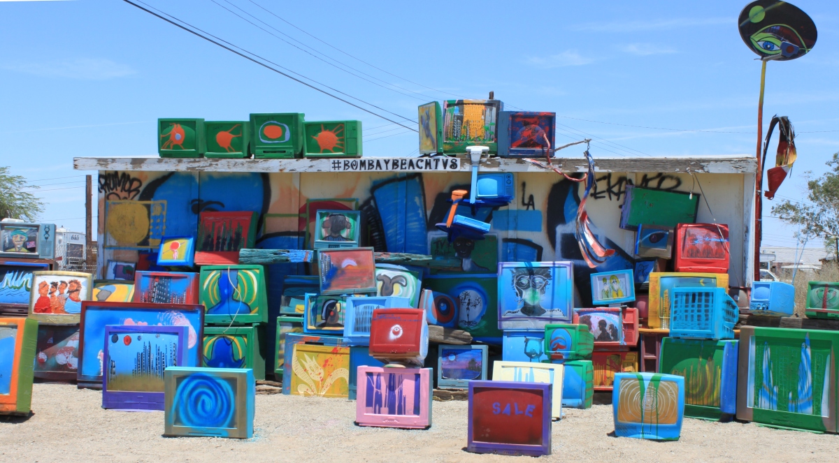
Anna Mazurek writes, “I walked between the rusting tire-less cars at the Bombay Beach Drive-In, snapping photos with each step. Arranged in four rows, the vehicles were all facing the screen: the white body of a semi-truck trailer. Two rows of Ferris-wheel seats were positioned directly in front. Like many things in the small Southern California town of Bombay Beach, the drive-in was an art installation. The town was the focus of a day trip from Palm Springs to the Salton Sea, the largest lake in California, in late October. My friend Miles and I drove 64 miles into the desert to explore one question: How did a small town along a shrinking lake become an arts destination? … ” Read more from the Washington Post here: On the shore of the Salton Sea lies Southern California’s hidden arts scene
SAN DIEGO
San Diego County supervisors accept plan for San Pasqual Valley Basin
“County supervisors on Wednesday unanimously approved a sustainability plan for the San Pasqual Valley Groundwater Basin. The plan will have the county be responsible for 10% of basin management costs within its jurisdiction. The basin is located 25 miles northeast of downtown San Diego, and is home to dairies, orchards and nurseries. Three creeks — Guejito, Santa Maria and Santa Ysabel — drain into the Basin and converge to form the San Dieguito River that flows southwest into Hodges Reservoir. … ” Read more from KPBS here: San Diego County supervisors accept plan for San Pasqual Valley Basin
Surfers were right: Imperial Beach is polluted with Tijuana sewage even in summer, study confirms
“Imperial Beach surfers and swimmers have long complained about foul smells along the city’s shoreline during summer months. For years, those concerns were swept aside as the Mexican sewage plaguing the town rarely spills over the border through the Tijuana River unless it’s raining. A new report out of UC San Diego’s Scripps Institution of Oceanography, Stanford University and the U.S. Environmental Protection Agency now confirms what many have suspected: A crumbling wastewater plant south of the border is daily discharging millions of gallons of raw sewage into the ocean that routinely carry pathogens up the coast. … ” Read more from the San Diego Union-Tribune here: Surfers were right: Imperial Beach is polluted with Tijuana sewage even in summer, study confirms
Along the Colorado River …
New research advocates a basic strategy for native fish recovery: Access to water
“Ri vers need water—a fact that may seem ridiculously obvious, but in times of increasing water development, drought, and climate change, the quantity of natural streamflow that remains in river channels is coming into question, especially in the Colorado River basin. Newly published research poses a tough question in these days of falling reservoir levels and high-stakes urban development: Whether the continued development of rivers for water supply can be balanced with fish conservation. … ” Read more from PhysOrg here: New research advocates a basic strategy for native fish recovery: Access to water
‘We have to do something’: New coalition seeks to protect Utah’s land, water
“Last year showed, yet again, the dangers that a changing climate have on Utah and the West. Federal scientists say the Western drought and wildfires each produced economic losses in the billions in 2021. They also believe there will be even more stronger storms, more wildfires and longer heat waves in the near future. That likelihood is why over a dozen Utah environmental and conservation groups are coming together in an effort help preserve the state’s land and water. They launched “Utah 30×30,” a coalition that seeks to find solutions to help conserve 30% of U.S. lands and waters by 2030. The group’s name is a play on the goals outlined in President Joe Biden’s “America The Beautiful” initiative released last year. ... ” Read more from KSL here: ‘We have to do something’: New coalition seeks to protect Utah’s land, water
Seawater tempting, costly drought defense for landlocked Arizona
“Arizona Gov. Doug Ducey’s plan to remove salt from seawater as an antidote to the landlocked state’s intensifying drought overlooks what water lawyers say is the best medicine: using less water. Ducey (R) said this week he is working with Arizona Republican leaders to invest $1 billion over the next three years on a state initiative to build large-scale water augmentation projects. The plan to secure the state’s water supply for the next century includes desalination, an increasingly common global solution to obtain fresh water but one more closely associated with coastal states such as California and countries such as Israel. … ” Read more from Bloomberg here: Seawater tempting, costly drought defense for landlocked Arizona
The precarious drought situation in Arizona
“Our holiday storm systems, the two that dropped rain and snow across Arizona over Christmas and again on New Year’s, had a nice, albeit small, impact on our short-term drought situation in the state. The U.S. Drought Monitor map is released every Thursday, showing parts of the United States in drought conditions. When you look at the numbers, a few things immediately pop out and can be attributed to those holiday storms. In the first 11 days of January, the state of Arizona that was classified to be in moderate drought conditions dropped by 4%. We were flat in both the severe, extreme and exceptional drought categories. But what really stood out is how far we have come since last year at this time. … ” Read more from Arizona Public Media here: The precarious drought situation in Arizona
Fifth-generation Pinal County farmer struggles to grow crops with less water
“It’s harvest season for Caywood Farms east of Casa Grande. The tractor is gassed up, the swather blades are sharp and Nancy Caywood is ready to farm. Only one thing is missing. “This all should be alfalfa,” Caywood said, standing in a dry field. “Every bit of this land should be in production.” Caywood walks across a dry, nearly barren field. Each step she takes, alfalfa crunches beneath her boots. A few stalks poke out of the ground. “Everything is dead out here,” Caywood said. … ” Read more from Tucson Weekly here: Fifth-generation Pinal County farmer struggles to grow crops with less water
PFAS water pollution pilot project opens in Tucson
“The Central Tucson PFAS pilot Project is officially up and running. The site is designed to remove PFAS pollution from groundwater north of Davis-Monthan Air Force Base. It will help protect Tucson’s central wellfield, a vital part of the area’s long-term drinking water supply. The PFAS pilot project is meant to clean municipal water well so they can be used again. Tucson-operated drinking water wells near Davis-Monthan Air Force base contain PFAS which are pollutants found in what was at one time common firefighting foam. … ” Read more from Arizona Public Media here: PFAS water pollution pilot project opens in Tucson
In national water news today …
Hydropower draws bipartisan support as renewable energy source
 “Drought, expensive facility upgrades, and a slow permitting process threaten the country’s ability to harness and expand hydropower to generate electricity, witnesses and lawmakers agreed at a Senate hearing that sought solutions to overcome the challenges. Democrats and Republicans both view hydropower as a unique and valuable renewable energy because it provides baseload electricity and can repower grids that collapse—an increasing concern after last winter’s devastating power outage in Texas. Hydropower provided 7.3% of total U.S. electricity generation in 2020, most of it generated at federal dams operated by the Army Corps of Engineers and Bureau of Reclamation. It’s a critical complement to other forms of renewable energy, but advocates say it lacks significant federal incentives for investors and industry that alternative sources like wind and solar enjoy. … ” Read more from Bloomberg Government here: Hydropower draws bipartisan support as renewable energy source
Environmental justice woes spring from lead pipe replacement
“A first-of-its-kind study offers fresh evidence that the widely used practice of removing only certain parts of lead service lines disproportionately plagues low-income, minority neighborhoods with drinking water contamination. The findings are fueling calls for EPA to ensure billions of infrastructure dollars being doled out to utilities across the nation through state revolving funds are spent equitably and comply with long-standing federal civil rights laws. “We think EPA needs to crack down and make sure states are affirmatively stopping the discrimination that can happen with these SRF monies,” said Tom Neltner, a senior attorney at the Environmental Defense Fund. … ” Read more from E&E News here: Environmental justice woes spring from lead pipe replacement
WaterSense considers expanding product categories
“The U.S. Environmental Protection Agency’s (EPA) WaterSense® program is considering expanding the types of products that can earn the WaterSense label to include systems that enhance water quality at the tap. EPA has published a Notice of Intent (NOI) to consider drafting a WaterSense specification for point-of-use reverse osmosis (RO) systems, which treat water at a single fixture, e.g., under the kitchen sink in a home. … ” Continue reading from Contractor here: WaterSense considers expanding product categories
Water scarcity is about to get a lot worse. Irrigated agriculture doesn’t have a plan.
“In much of the West and Southwest, the climate crisis is projected to raise average temperatures while reducing snowpack for much of the foreseeable future. These trends will significantly increase the risk of drought in an area heavily dependent on irrigation for food production. So what’s the plan? For many farming communities, there is none. That’s according to a new report on drought preparedness published by the Department of Agriculture (USDA), which found that approximately 80 percent of irrigation organizations don’t have a formal plan for responding to future water scarcity. … ” Read more from The Counter here: Water scarcity is about to get a lot worse. Irrigated agriculture doesn’t have a plan.
Global temperatures in past seven years hottest ever observed, new data show
“The last year was the earth’s sixth-warmest on record, while the past seven years were among the warmest ever recorded, according to research released Thursday by NASA and the National Oceanic and Atmospheric Administration. The NOAA analysis found that while Earth was slightly cooler than 2019 and 2020, 2021 was still among the warmest on record dating back to 1880. Every year from 2013 to 2021 was among the ten warmest recorded years, and 2021 was the 45th consecutive year with global temperatures above the 20th century average, according to the agency. The average land and ocean surface temperature during the year was about 1.5 degrees above the 20th-century average. ... ” Read more from The Hill here: Global temperatures in past seven years hottest ever observed, new data show
2021 was the sixth hottest year on record
“Earth experienced its sixth hottest year on record in 2021, scientists from NOAA and NASA announced today. The title for all-time hottest year still goes to 2020. It’s the latest installment in a relentless pattern of global warming, driven by greenhouse gas emissions. The seven hottest years on record have all occurred in the last seven years. Each of those seven years has been at least a degree Celsius warmer than the 19th-century average, the baseline scientists use to estimate Earth’s temperatures before the industrial revolution. Each of the past four decades has been warmer than the one before. And there’s been an overall warming trend on Earth for decades longer. … ” Read more from E&E News here: 2021 was the sixth hottest year on record
National water and climate update …
The Natural Resources Conservation Service produces this weekly report using data and products from the National Water and Climate Center and other agencies. The report focuses on seasonal snowpack, precipitation, temperature, and drought conditions in the U.S.
dmrpt-20220113Also on Maven’s Notebook today …
DELTA eNEWS: ~~ Deadline Extension~ Information Booth~ CWC Meeting~ Public Review ~~
WORKSHOP NOTICE: January 20 State Water Board Workshop, Drinking Water & Waste Water Allocations from 2021 Budget Act
NOTICE of Temporary Water Right Permit Application T033270 to Appropriate Water from Cache Creek in Yolo County

