

Ted Grantham is a Cooperative Extension Specialist at UC Berkeley and the CalTrout Ecosystem Fellow with the Public Policy Institute of California. He studies water, climate, and water management with a focus on the environmental consequences of the ways in which we manage water in this state and throughout the world. In this presentation, Dr. Grantham discussed environmental flows and the policy context in California in which environmental flows are managed and how that has evolved over time.
PART 1: WHAT ARE ENVIRONMENTAL FLOWS AND WHY DO THEY MATTER?
Mr. Grantham began with a depiction of earth’s water (lower, left), noting that the largest blue sphere represents all of the water on earth, including in the oceans and streams and glaciers. The smaller middle sphere represents all the freshwater on earth, which includes water that both occurs underground and in glaciers. The third, smallest dot (barely discernible) represents the surface waters available in the rivers and streams.
“So we’re talking about a very small portion of the land surface – maybe less than 1% of the land surface and less than .1% of all global water is really the focus of what we’re trying to manage and protect,” said Mr. Grantham. “This resource not only sustains organisms and rich biodiversity but also people are highly dependent on these surface waters in rivers, streams, and lakes, and we put tremendous pressure on this resource to support our economies, our agricultural sectors, our cities, and to have fun, to fish and raft and recreate.”


One of the ways in which our water management put pressures on our freshwater resources is through the construction of dams. Dr. Grantham presented a graphic from a recent assessment of the global distribution of dams (upper, right), noting that there is an extremely high concentration of dams, particularly in places like the United States, California being no exception. There are about 1500 dams in the state considered large dams as well as tens of thousands of smaller dams.
“Collectively, these water projects have really transformed both the physical and biological characteristics of our rivers and streams,” he said. “We know that they not only create barriers to fish movement, but they profoundly change the flow regimes, the timing and the volume of water that’s passing through them and as a consequence, they also change the ecosystem services and goods that are provided by healthy intact river systems.”
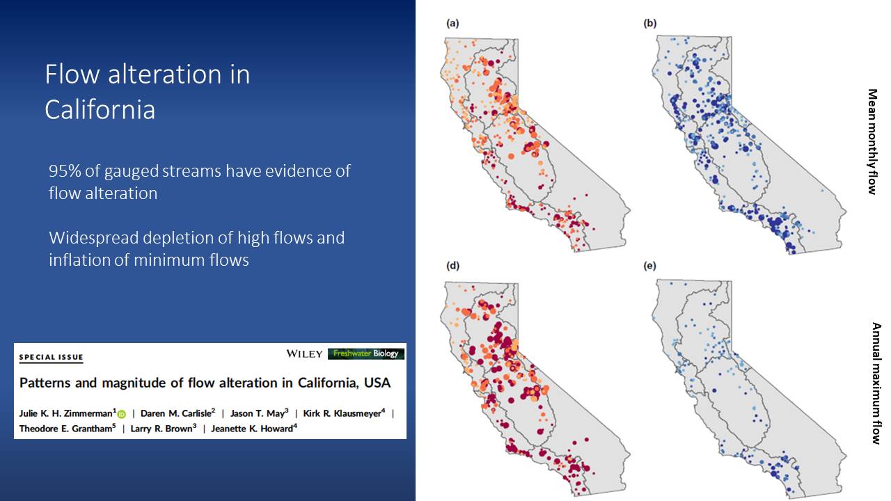 Looking at stream gauge data is one way to study how river have been altered in California. USGS has a network of stream gauges distributed throughout the state, and modeling tools are used to predict what flows would be present in the absence of dams and compare that to the observed conditions under our current or prevailing management regime.
“Nearly all of our gauged streams show evidence of flow alteration,” said Dr. Grantham. “In particular, we see widespread depletion of high flows, so our high flows are getting lower, and our low flows tend to be getting higher which has been described as homogenization or stabilization of the flow regime in many of our rivers and streams. This reflects how we manage these systems to provide reliable water supplies by capturing as much water as we can in the winter months and then often release the stored water in the summer months to provide water for downstream users.”
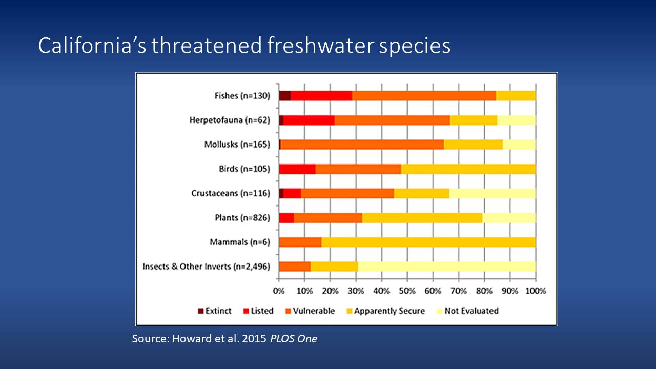 One of the consequences of these changes has been the widespread decline of native freshwater species from fishes to freshwater dependent mammals to waterbirds. An assessment done a few years ago determined that an extremely high percentage of our native freshwater species in California are now threatened; the changes in flow from dams and other human activities aren’t the only cause but they are a very important one, he said.
The focus of environmental flows addresses the fundamental question of how much water does a river need and how can our surface water systems, our rivers, streams, and lakes be managed in ways that preserve the volume of water that’s really needed to sustain healthy ecosystems while also meeting human demands. This is a question that has risen to the attention of the scientific community over the past 20 or 30 years.
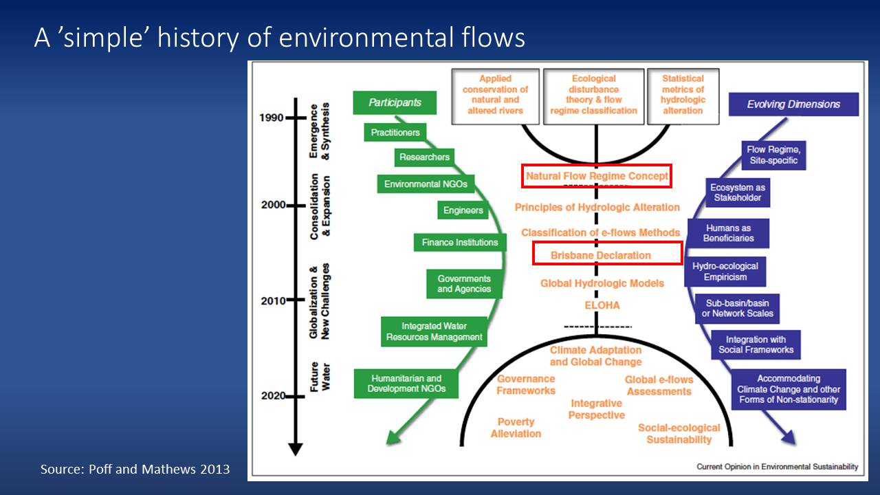 Dr. Grantham presented a graphic from a recent paper that depicts the evolution of environmental flows and the growing recognition of the importance of conserving or preserving water for the environment as expressed through various policies and changes in scientific advances. Broadly speaking, over the past 30 years there has been both an increasing awareness of the importance of securing water for environmental benefits and an increase in the number of participants involved and engaged in this process, from dam operators to organizations concerned with sustainable development at a global scale; the movement is towards much more integrated ways of approaching water management that incorporate ecosystems in a more effective way.
He highlighted two key contributions: The natural flow regime concept and the Brisbane Declaration.
The natural flow regime concept
This was a seminal paper for thinking about approaches to managing environmental flows. “The paper simply stated that the ecological integrity or the health of river ecosystems really depends on their natural dynamic character, or in other words, rivers are inherently dynamic systems and the only way we can preserve their health and the services they provide is by maintaining some degree of that dynamism,” he said. “The second thing this paper did was focus really holistically on flow regimes; the paper identified these different aspects of the flow regime described by the magnitude or volume of water, the frequency of particular flows, the timing, the rate of change of the flows, and how they related to different aspects of the ecosystem that then supported ecological integrity, so the timing and volume of flow controls water quality, the fluxes of energy, physical habitat, the movement of sediment for example, as well as sending important signals to species, for example, for salmon to migrate.”


The paper lays out some of the principles of how different facets of the flow regime relate to different ecosystem attributes that have been identified. “The flow regime and this variation in flows from high flows to low flows all serve very important roles in supporting ecosystem health, from providing the disturbance agent that both creates habitat and disturbs habitat to creating opportunities for other species by triggering a certain life history strategies like spawning and migration, and importantly also connecting habitats like our floodplains when we get high flows.”
The Brisbane Declaration
The Brisbane Declaration came about in 2007 as a result of the growing appreciation of the importance of natural flow variation and natural flow regimes for ecosystems as well as an increasing appreciation for the services and values that are provided to people and to society by healthy ecosystems. The Declaration represented the views of an international group of river scientists who took on the challenge of defining environmental flows for use in various policy contexts.
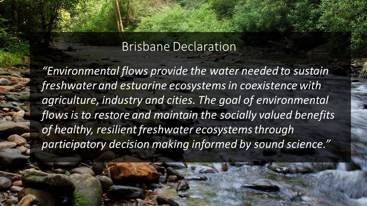 “First of all, under this definition of environmental flows, it’s not simply defined as water for the conservation of biodiversity; it’s really focusing on the benefits that society and people derive from healthy ecosystems,” said Dr. Grantham. “It also focuses on the need to really balance the needs of ecosystems with the needs of people in sustainable ways, and it highlights the role of both the importance of participatory decision making in making decisions around environmental water and the role of science. I think this declaration really reflects the scientific community’s current understanding of environmental flows and how we should approach managing environmental flows in different contexts.”
PART 2: ASSESSING AND MANAGING ENVIRONMENTAL FLOWS
Next, Mr. Grantham discussed some of the technical approaches for quantifying environmental flow needs, in particular rivers, acknowledging that it’s both a scientific and a social process.
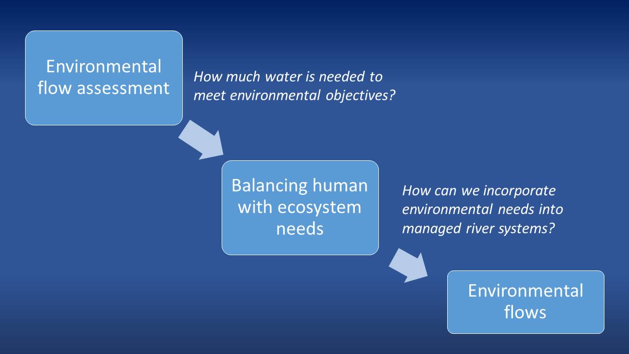 He said it’s really a two-step process: First there is the technical and scientific process which considers the particular environmental objectives we want to achieve, such as a healthy salmon populations or maintaining water quality for drinking; once those objectives are defined, it’s really a scientific question or technical process to figure out what is the water needed to achieve those objectives. The next step is balancing, which involves incorporating these needs within the water management system in relation to all the other demands that are placed on the ecosystem.
“In California, it’s really the State Water Board that’s responsible for achieving this balancing, but hopefully if they do that process well, we’ll end up with recommendations for how to meet environmental water needs while minimizing impacts to other water users,” he said. “That first process is really a technical process which involves primarily scientists and technical aspects and the second one is more of a social and political process that is led by agencies and through participatory decision making.”
There are three approaches commonly used for quantifying environmental flow needs: hydraulic habitat methods, hydrologic methods, and statistical or eco-flow methods.
Hydraulic habitat methods
The first class of methods focuses on the hydraulic conditions of rivers and streams as a function of flow; Mr. Grantham explained that by hydraulics, he is talking about the variation in depths and velocities that occur in stream channels at different flow rates.
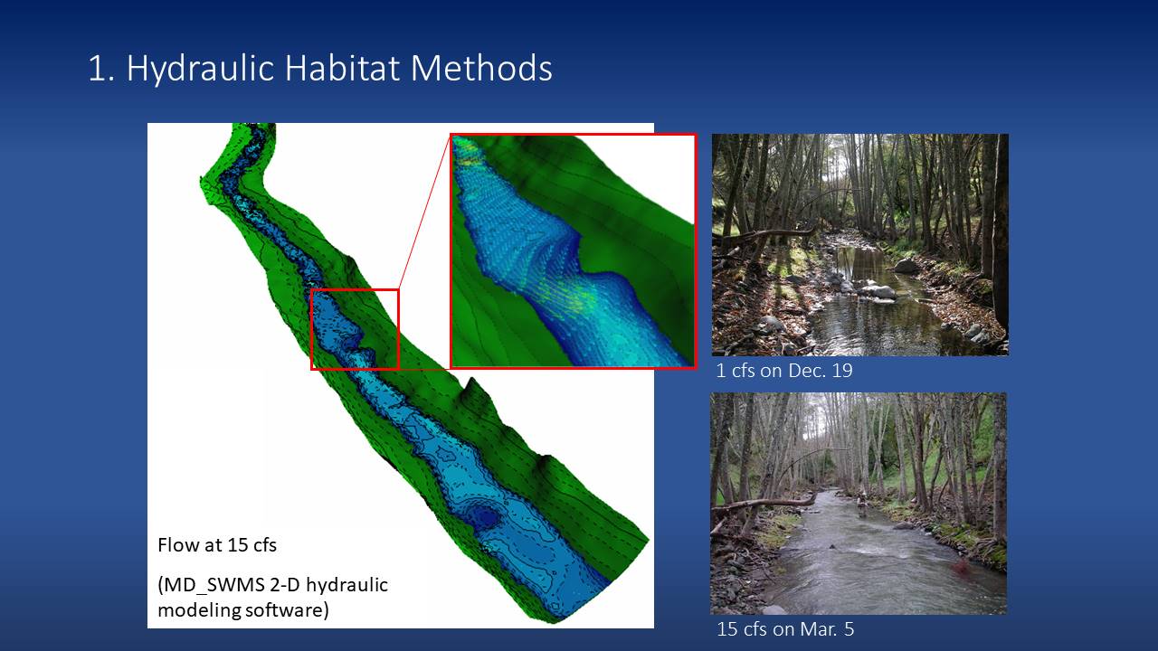 “It really recognizes this interaction of flow which is a volume of water per unit of time moving through the physical structure of the channel and creating variation in depths and velocities that different species are adapted to take advantage of,” he said, presenting an example of a hydraulic model of the depths and velocities for a particular flow rate for a stream in Sonoma County.
Once the physical behavior of the rivers has been modeled, which looks at how the velocities and depths for the rivers change across a range of flows, they can then start to incorporate information about habitat for the particular species that are being managed for. This is a common approach for salmon and trout in particular which have very specific preferences for the ranges of depths and velocities; observational studies are done to figure out where particular species are within the river channel in terms of depths, velocities, substrate, and other factors that is then linked to the model outputs to generate weighted usable area curves.
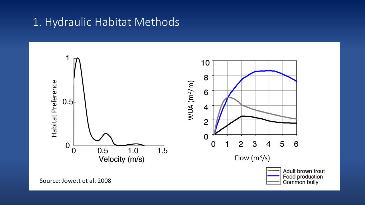 Dr. Grantham explained that the graph on the right shows the total available area of habitat that changes as a function of flow. “So for example, the blue line represents how food production increases with flow to about 4 cubic meters per second and then decreases,” he said. “You can see how the suitable habitat for these two other species, adult brown trout and common bully have certain different responses; for the bully it really peaks at 1 cubic meter per second and then declines, whereas the adult brown trout peaks a little bit later. These types of curves can then be translated into flow recommendations, so if you were trying to manage the system as a trout fishery, for example, you might recommend a seasonal base flow of 1 cubic meter per second in this particular river or stream.”
Hydrologic methods
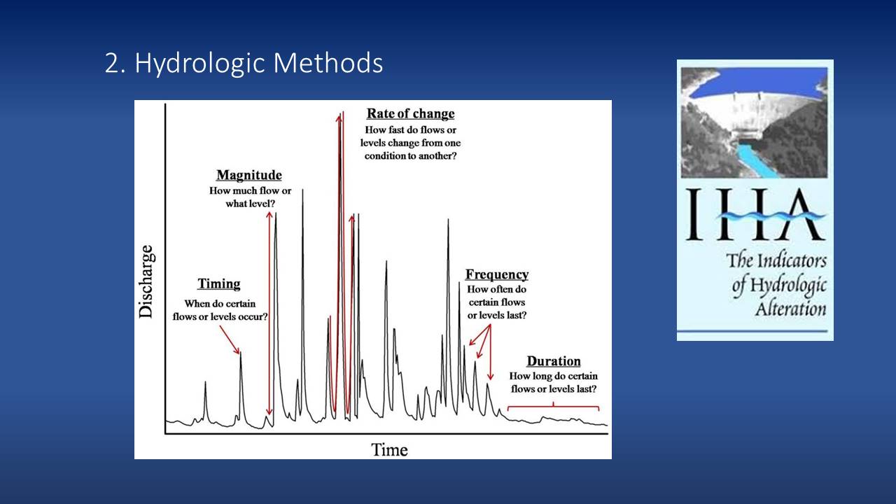 Another class of approaches are hydrologic methods which focus on the hydrologic characteristics rather than the ecology of the rivers. This approach focuses on characterizing different aspects of the flow regime. The graph on the slide is a hypothetical hydrograph showing daily flow or discharge plotted over time.
“We can describe these sort of erratic patterns by a suite of characteristics, so we can look at the timing of when certain flows occur, the magnitude and how high they get, how quickly flows change, the number of times that certain peak flows of certain magnitudes, and then the duration of particular flows like base flows, for example,” Dr. Grantham said. “These characteristics of flow regimes can be quantified by particular metrics, so we can look at the average flow in July or the one-day minimum flow, and we can quantitatively describe these metrics. We might look at a gauge that has minimal human influence and quantify these various metrics and use that as a reference for how we might set objectives for different types of rivers.”
Statistical or eco-flow methods
 A third class of approaches uses statistical methods to define the ecological flow relationships by relating some sort of flow characteristic or metric to some ecological or biological response, Dr. Grantham said.
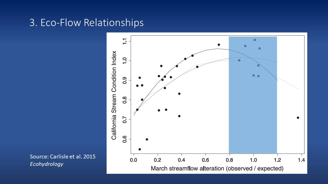
“On the Y axis is a stream condition index which is derived from biological monitoring data of stream macroinvertebrates so basically insects that live in these streams are sampled at a site and depending on the abundance and diversity of those samples, they are assigned a condition index which represents sort of gradation of poor to high quality,” he explained. “So we can plot that condition index against some measure of alteration, and in this case which is from a stream in the Sierra Nevada, when March streamflows are depleted or when observed values are below expected, we see a decline in stream condition. It’s really this range between 20% change in flow that we maintain these higher condition factors or index values.”
The next step in the process, regardless of the method that’s used, is to translate these relationships into environmental flow recommendations. He noted that often multiple methods are used when working to develop environmental flow recommendations depending on data availability or the target objectives.


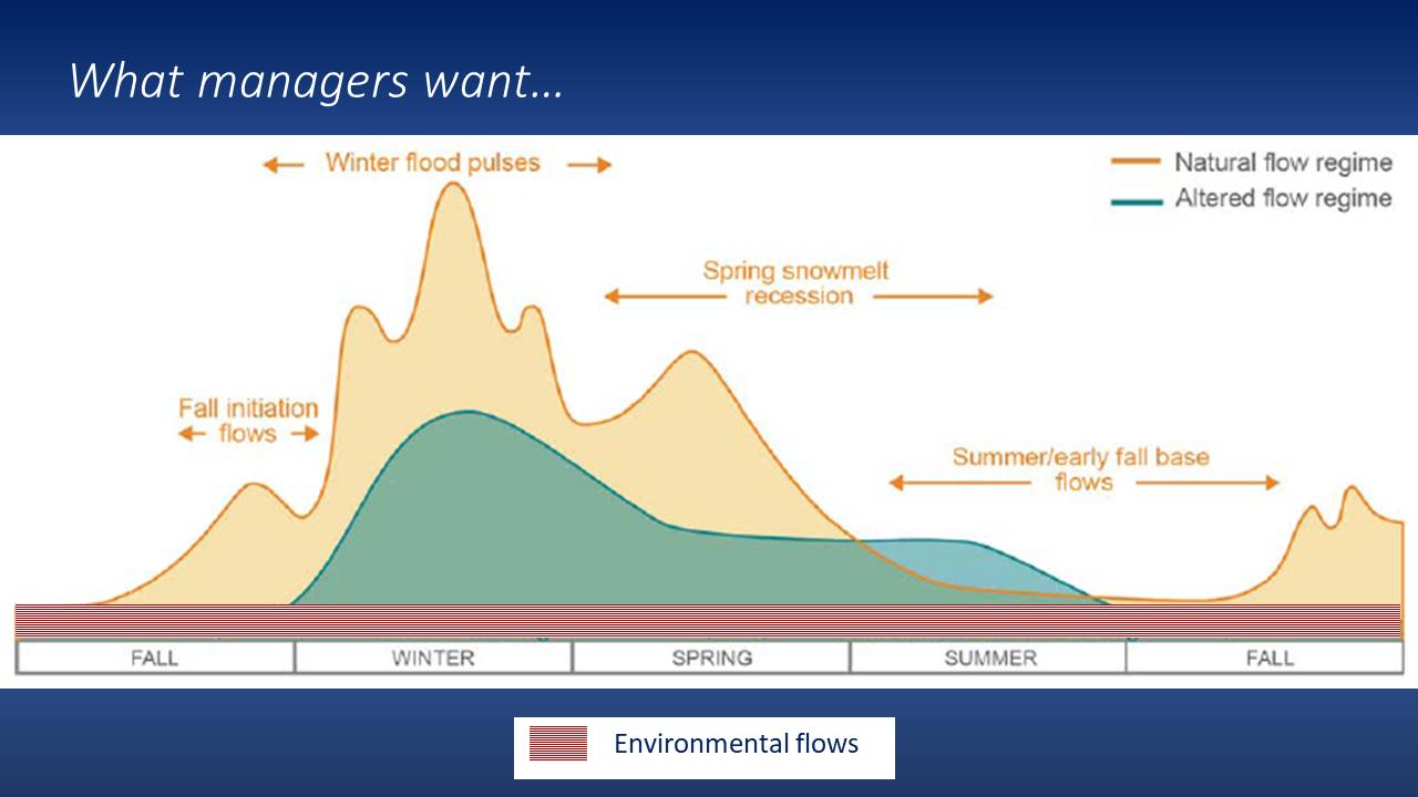
The schematic on the slide on the upper right is a gross simplification of what a natural flow regime might look like for a river in the Central Valley. The green represents what a typical altered flow regime would look like under a typical management regime; the difference between the brown and green shading indicates depletion of winter flows and the loss of variability, particularly throughout the winter and the potentially augmented flows in the summer time when water is being released for downstream urban and ag uses.
“What scientists challenged with making recommendations for how to restore a healthy ecosystem would want would be a hydrograph that might look something like this, where you would be bringing back patterns of natural variation in the system – not necessarily the full amount of water, but certainly bringing back certain patterns of variation in the system and basically restoring variation,” Dr. Grantham said. “Of course, there are many challenges to implementing this type of approach. Like one, even if it is not restoring the flow regime, it would still take a lot of water, and two, from practical perspective, it’s just hard to dynamically manage flows below reservoirs in this way.”
 What water managers want is a number; they want to know how much water is needed for the environment and ideally one that doesn’t change very much, he said. “Historically in California and elsewhere, this has often been the de facto approach for allocating environmental flows where you would have a rule, such as a minimum of 5 cf should be released from a dam for a particular period of time. What this translates to in terms of environmental flow prescription is like a flat line flow that may very between winter and summer but generally is quite stable, which we know from both standard ecology theory as well as empirical evidence that this is likely to be insufficient for restoring healthy ecosystems in most cases.”
The common ground with this type of approach is to have a more seasonally variable hydrograph that brings back some elements of variability but is still workable within the context of dam operations.


The end result would be an approach where there are still minimum flows that would be required but some variation in flows would be introduced at critical times of the year that are relevant for both supporting key physical processes like sediment mobilization as well as ecological processes like migrations and spawning.
“This would be a hypothetical example of a more nuanced approach for managing environmental flows in California rivers,” Dr. Grantham said.
EXAMPLE: PUTAH CREEK
One of the examples in California where this type of approach has been implemented is in Putah Creek, which is just outside of Davis, California. Putah Creek flows out of Lake Berryessa behind Monticello Dam and flows east into the Central Valley through an area that is dominated by agriculture.


The major changes for Putah Creek occurred in the 1950s when Monitcello Dam was built in the headwaters in the Coast Range, coupled with a diversion dam built downstream for irrigation projects. For the last 20-30 years, the fish community has been monitored within Putah Creek and it shows an interesting pattern of a fish species, Dr. Grantham said.
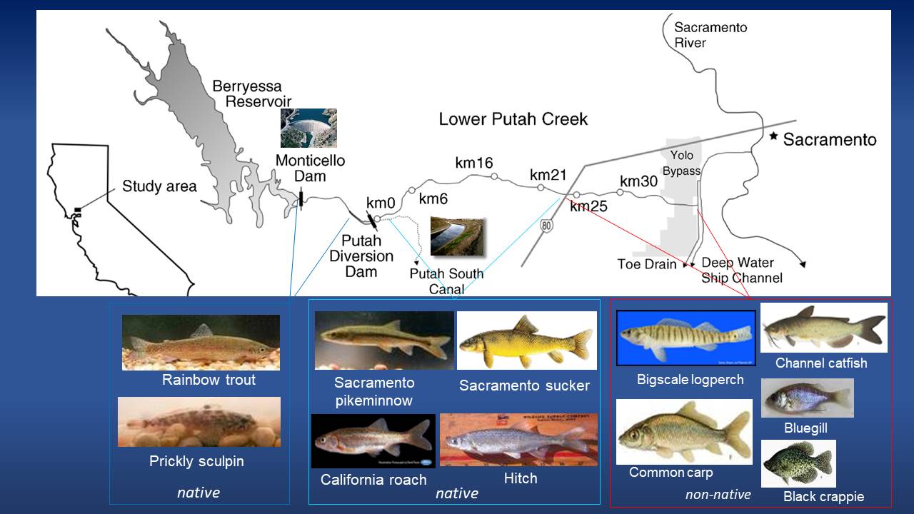
“Immediately below the dam, where flows are actually maintained at a pretty high rate pretty much year around, you actually see a healthy trout fishery because trout tend to like cold water and relatively stable flows and so you actually see a fish assemblage or fish species that are dominated by natives,” he said. “As you move downstream to the lower Putah Creek below the diversion dam, you see a very different suite of species, also primarily historically dominated by native species but more characteristic of the warmer, Central Valley waters; these are fish like the pike minnow or the Sacramento sucker, hitch, and California roach. And as you move down even lower into the system as you start getting close to the Yolo Bypass and where Putah Creek actually flows into the Sacramento River, we tend to see more non-native species. This is because the habitats within this reach have been highly altered and are no longer suitable for native species.”
In the 1980s, there was a drought that led to even less water flowing down to lower Putah Creek, and as a result, the creek dried, there were a lot of fish die offs, and a lot of concern that the native ecosystem of Putah Creek was on the verge of collapse. So UC Davis and environmental organizations went to court with the irrigation district which led to several years of litigation that ultimately culminated in an agreement known as the Putah Accord.
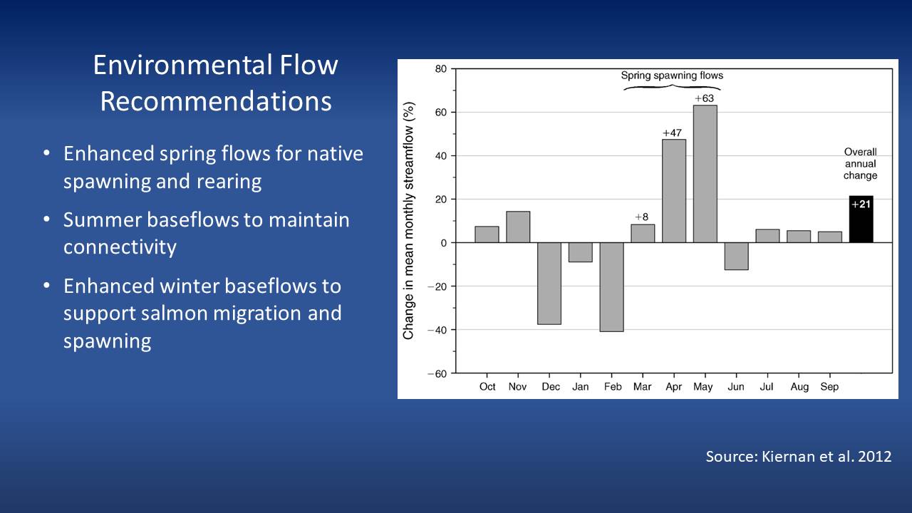 “Within this accord, they recommended that the total amount of water allocated to the environment be increased on the order of overall about 20%, so we’re not talking about a substantial change in the total amount of water allocated, as it still represents less than 10% of the total annual volume of the river itself,” Dr. Grantham said. “Most importantly, they recommended that these environmental flows be allocated at times of the year that are most beneficial for native species, and in this case, this was really targeting the spring period when many of these native fish species breed, and they’re adapted to take advantage of the natural high spring flows that would have occurred in an unregulated or undammed river system. There were also some recommendations to increase winter base flows and to send flows to encourage and protect salmon migration.”
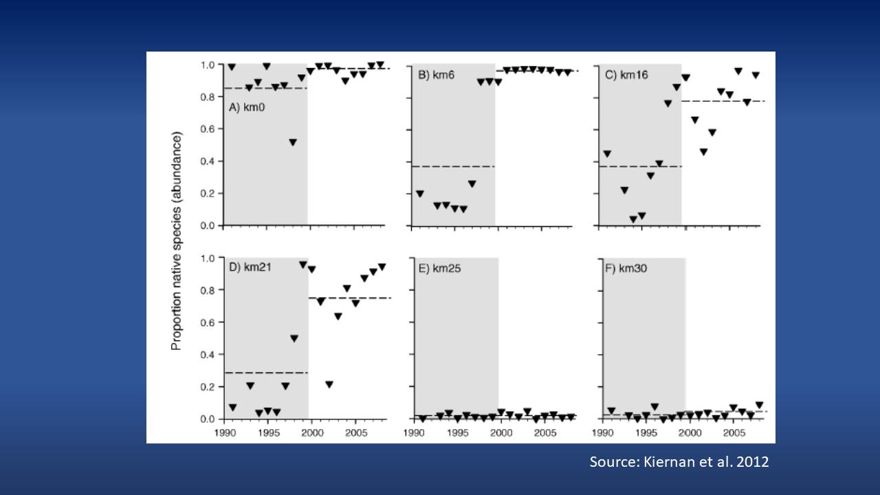
After the change in management regime brought on by the Putah Accord, there was a clearly documented response in the system. He presented a slide with a series of graphs that show the changes in the proportion of native species from the top of the river near Monticello Dam down towards the confluence with the Sacramento River. Kilometer 0 is at Monticello Dam, kilometer 6 is the diversion dam, kilometer 16 to 21 is close to Davis and kilometer 25 to 30 is even further downstream. The grey bars show the proportion of native species that were observed in the river prior to the Putah Creek Accord, and the white area to the right are the post Putah Creek Accord, or after this new environmental flow regime was implemented.
In the upper watershed right below the dam, there already were primarily native species occurring in the area and as the new regime was implemented, it became almost exclusively native species. In the middle reaches between kilometer 6 and kilometer 21, there was a major uptick in the proportion of native species and a reduction in non-natives as a result of the changes in timing and volume of flows, and the particular focus on the spring flow conditions.
 He noted that in the lower reaches, there really wasn’t any effect. “That speaks to the importance of habitat where these systems in these lower reaches are so degraded that even though we provided these additional flows that were targeted at native species, the habitat simply wasn’t there to take advantage of that additional water and that other factors were limiting the recovery of native species,” he said. “So here we see a clear example that changing the timing and the volume of water to meet the needs of these native species can really have a positive effect.”
After the new management regime was implemented in the 90s, there was a recovery of native fish, native birds, and riparian vegetation, which has resulted in a tremendous amount of community interest and support in the health of the creek.
“The river itself has become a focal point and one of the great aspects of living in the area, and the irrigation district has become an incredible steward of the resource and are very invested in maintaining the health of this system,” Dr. Grantham said. “This is what Peter Moyle often refers to as a reconciled ecosystem where we start with a period of conflict between competing human needs and environmental needs over water and then we’ve reached a solution here that actually works for both people and the environment and it works quite well. Environmental water can often be a source of great conflict and many see it as a zero sum game, but I just don’t think that’s the case.”
PART 3: CURRENT STATUS AND OUTLOOK FOR ENVIRONMENTAL FLOWS IN CALIFORNIA
Dr. Grantham then gave his perspective on the current status of environmental flows and how the issue is evolving in California, in particular.
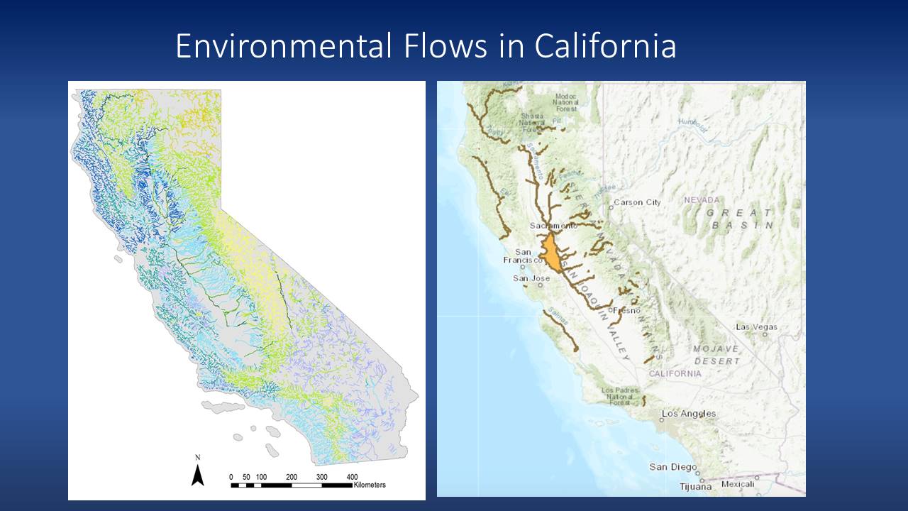 The map on the left shows all of the rivers and streams in the state; the different colors represent streams with different characteristics in their flow regimes. The map on the right shows the rivers for which environmental flows have been established and recognized in a legal way, often through biological opinions, endangered species act regulations, water quality regulations, or FERC regulations that manage hydropower dams.
“The point of showing this map is just to say that even though many of our large rivers like the Sacramento and the San Joaquin do have environmental flow protections to some degree, most of our rivers and streams do not,” he said. “This is a problem and a concern when we look to the future particularly for species like salmon that are really going to depend on reliable sources of cold water into the future.”
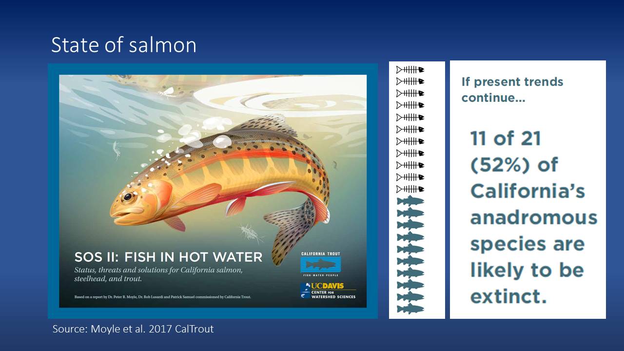 A recent assessment determined that if present trends or present management regimes continue as they are, we can expect to lose about half of the salmon and trout in the state. “So what this says to me is that again, water is not the only issue that needs to be addressed in restoring our habitats, or protecting these fish populations, but water is certainly a key component.”
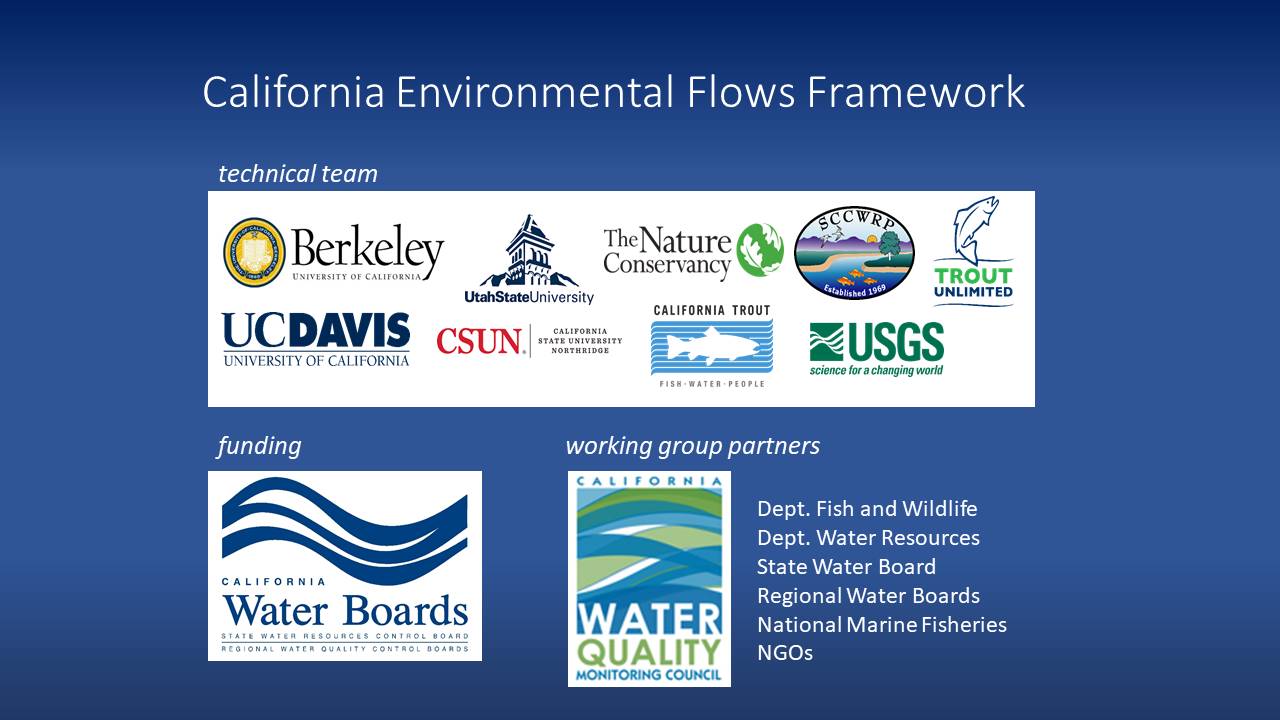
To address this challenge, the California Environmental Flows Framework is an initiative and a broad effort to improve both the scientific rigor of the way environmental flows are quantified and implemented as well as simply increase the pace and effectiveness of environmental flow management throughout the state. The participants include academic institutions, NGOs, the USGS, state agencies, and the federal fishery agencies with funding provided by the State Water Board.
 One of the key aspects of this effort is a working group that’s involved with a lot of the management agencies that have a nexus here with environmental water, such as the Department of Fish and Wildlife and the State Water Board, among others.
“This environmental workgroup has really been a forum for talking about the challenges and technical approaches for managing environmental flows in the state,” said Dr. Grantham. “The mission of this workgroup is to really advance the science of environmental flows but also advance its application for supporting management decisions and particularly in addressing decisions that are attempting to manage resource needs with consumptive water use. This group is a public group that’s been meeting for a few years now and we’re really trying to tackle these issues around environmental flow management.”
The group is overseeing the development of both technical projects, such as the scientific analyses and tools needed to inform decision making, and implementation projects which are more guidance documents and thinking about engaging broader groups in this effort.


The environmental flows framework is a two-tiered approach that provides guidance for defining environmental water needs or environmental flows for any river or stream in the state. The first tier provides an approach for setting flow targets statewide at any river or stream; it’s a reference base because it uses information on the natural reference hydrology or what hydrology would be in the absence of human activities. However, that’s not relevant for many of the state’s managed systems so in tier two, they provide guidance for how to refine those recommendations to address the unique management context or unique management objectives that may exist in different parts of the state. Overlaying all of this are key principles around open data and information to the public so that it can be a very transparent process.
Underlying the framework is a functional flows approach. “The basic idea behind functional flows is that it basically recognizes that there are particular aspects of the flow regime that are disproportionally important in supporting both physical and ecological functions in rivers and streams,” said Dr. Grantham.
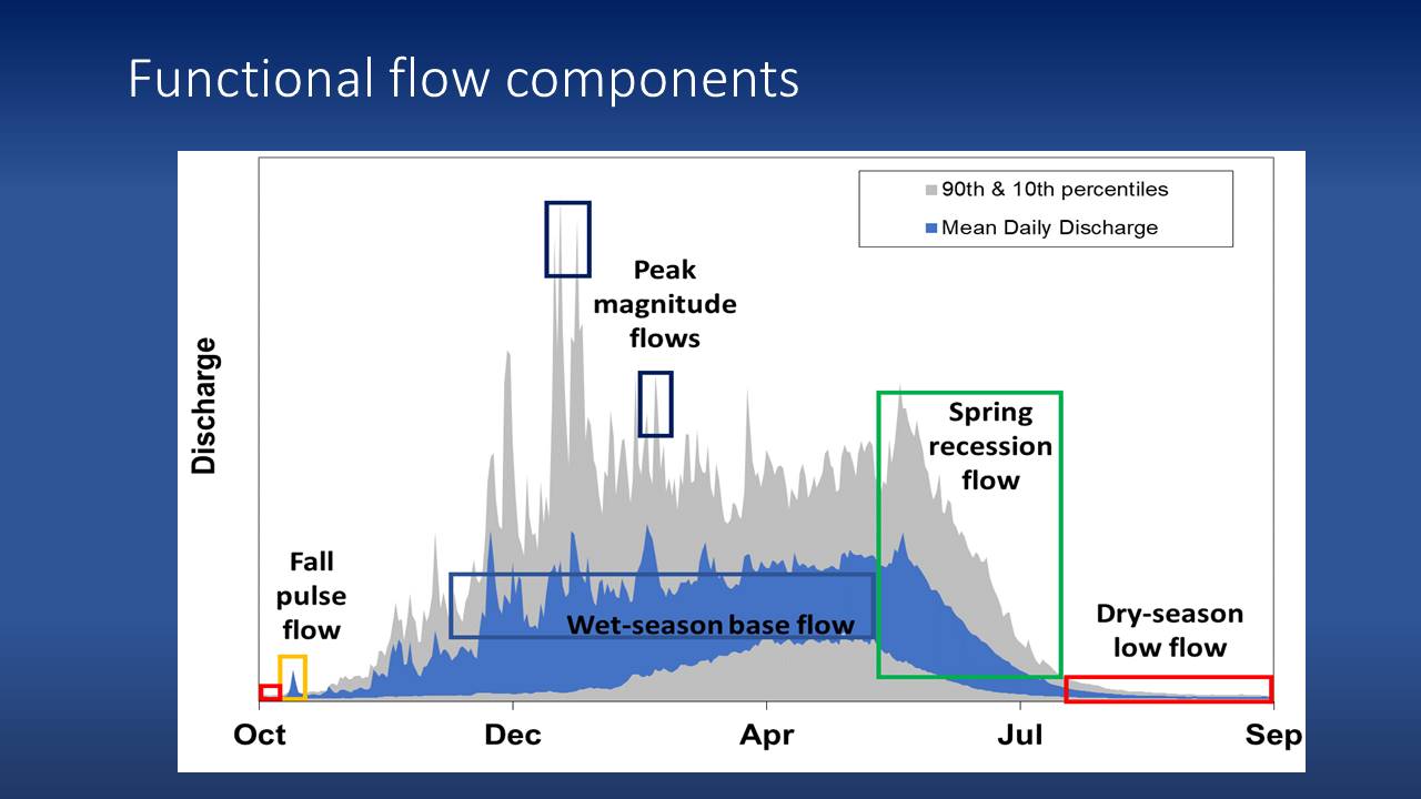 “There’s been a lot of research underlying this conceptual approach of functional flows that has helped us to identify these functional flow components,” he continued.” These include the fall pulse flow, which is generally the first storm of the winter season that remobilizes organic material and it can also serve as a signal for a lot of species. Winter peak flows do a lot of physical work and provide triggers for migration, and wet season base flows can be really important for maintaining connectivity within river networks to allow for things like fish migration or spawning. The spring recession flow can be very pronounced in snowmelt systems but also occur in rainfall systems and then the dry season low flow period is very important in many systems for maintaining a living stream in perennial systems.”
The flow components were identified by drawing upon years of studies of rivers in California to hone in on the most important aspects of river flows. “What we do as part of this process is we can quantify those components by different metrics, so for example, we can look at the fall pulse and we can describe the characteristics of that flow pulse in terms of its magnitude and timing; we can look at the wet season base flow and characterize that in terms of its magnitude, timing, and duration. So each of the Xs on the chart represents a different way in which we can define these different components. The idea here is that we can then take those quantified metrics and do subsequent analysis to inform their ecological significance or use information on the natural ranges of these various metrics to set environmental flow recommendations.”
“The idea here behind a functional flows approach for setting environmental flows would be something like this where we would have again not be restoring the full natural flow regime but would be really honing in on particular functional flow components like the fall pulse flow, the wet season flow, the spring snowmelt recession, to make sure that those key functions of rivers, both ecological and physical, are preserved,” Dr. Grantham said. “We think this approach is promising in a California context because it certainly uses less water than attempts to preserve the full natural range of variation, it’s supported by our science which says these certain components of the flow regime we know are really important ecologically and it potentially can use less water.”


Lastly, in order for the functional flows approach to work, we also have to couple the way in which we manage environmental flows with structural habitat improvements, he said. “In places like the Central Valley, we’re only going to realize the benefits of these functional flows, particularly the high flows, if they are able to access the landscape and recover the processes that make these flows so important. In the winter, for example, when we would historically have seen vast areas of the Central Valley flooded in association with those high flows, those were often really important times both for fish breeding and for fish growth. This is to say that flows in many ways are necessary but insufficient condition for restoring the health of ecosystems and that we also need to couple those flows with habitat improvements.”
For more information on environmental flows, visit: https://ceff.ucdavis.edu/
 “There has been an evolution of environmental flow approaches and I think we’re at a transition point now where we’re moving away from minimum flow protections to an approach that’s a bit more nuanced and recognizing that we have to restore some dynamism in these systems to achieve our objectives,” he said. “Very few rivers in the state actually do have formal environmental flow protections and those that do often focus on single species or even single life histories of species. I think we can do better, and some of the tools and approaches that we’re developing through this environmental flows framework should help to really increase both the scale and effectiveness of environmental flows in California.”
FOR MORE INFORMATION …
Photo credit: Brandy Creek in the Whiskeytown-Shasta-Trinity National Recreation Area; Photo by Wayne Hsieh via Flickr.

