

 The ongoing statewide drought and implementation of the Sustainable Groundwater Management Act have triggered increased interest in capturing high surface water flows for the purpose of recharging groundwater basins. As part of the Executive Order Governor Brown issued in November 2015, the State Water Board was directed to expedite temporary permits for capturing high precipitation events for local storage or recharge, consistent with both water right priorities and with protection of fish and wildlife; the order also suspended CEQA for these types of projects.
In water year 2015-16, two temporary permits were issued. At the December 6 meeting of the State Water Resources Control Board, staff provided an update on the program, which included presentations from the two projects implemented last year, and and some of the broad project-level questions that have come up in the process of issuing these temporary permits.
BACKGROUND ON GROUNDWATER RECHARGE
Amanda Montgomery, Environmental Program Manager with the Division of Water Rights permitting and licensing program, began the presentation with some background information.
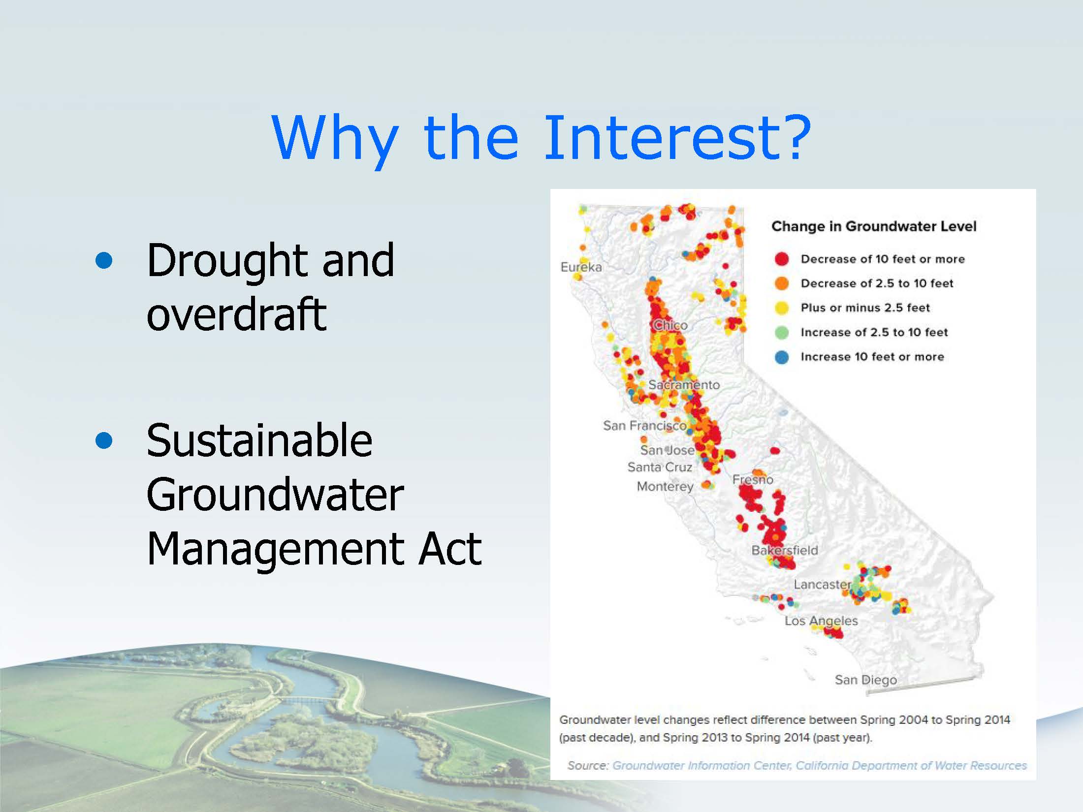 California’s groundwater aquifers contribute more than 38% of the state’s water supply, and they are particularly important in times of drought. In many parts of the Central Valley, water levels in groundwater aquifers have dropped 10 feet or more in the past year. Many aquifers have become serious depleted; the Department of Water Resources as of January 2016 has listed 21 basins as critically overdrafted. Artificial groundwater recharge projects are one method of addressing storage in these basins.
In November of 2015, the Governor issued an executive order that, among other things, directed the State Water Board to expedite temporary permits for capturing high precipitation events for local storage or recharge, consistent with both water right priorities and with protection of fish and wildlife. The order also suspended CEQA for these types of projects; that will basically be in effect, we believe, until the drought state of emergency is terminated, she said. Additionally, in December of 2015 the State Water Board reduced the filing fees usually charged for these types of permits.
Ms. Montgomery noted that in addition to the drought, the implementation of the Sustainable Groundwater Management Act will likely increase interest in these types of projects. “Some of these local agencies may be looking for solutions and this temporary permit or even standard permit will be one of the things they may look at,” she said. “The deadlines for the SGMA plans are 2020 and 2022 for the high and medium basins, so it that’s a little further out.”
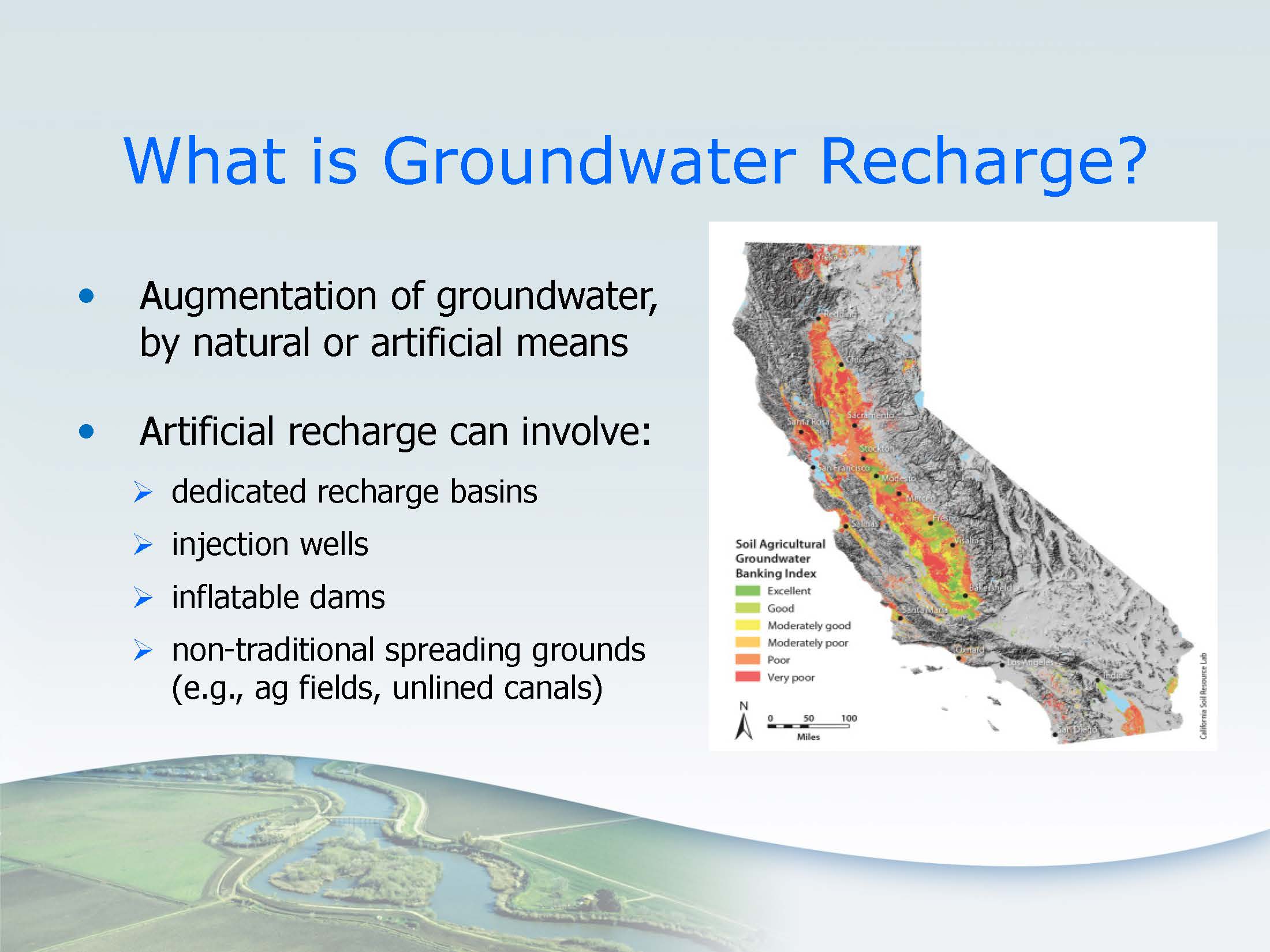 Groundwater recharge is the augmentation of groundwater, either naturally such as by rainfall, or artificially. This recharge can happen by diverting water to large recharge basins that infiltrates into the aquifer, by using injection wells, or by impounding water in a channel with an inflatable dam or a check dam or other approaches to increase infiltration.
“There’s been more interest recently in some less traditional mechanisms, such as using agricultural fields or unlined irrigation ditches for infiltration,” Ms. Montgomery said, noting that the map on the slide was produced by UC Davis and UC Cooperative Extension, and it shows an index they developed for identifying agricultural lands that may be appropriate for recharge projects. “One thing to point out is that some groundwater recharge projects may be based on short term water surpluses that occur only infrequently assuming that water is available.”
With respect to groundwater and water rights, it’s complicated, she acknowledged. “If a party decides that they want to take water from surface water like a river or a stream and they want to use that water to recharge a groundwater aquifer, they’ll need some type of water right,” she said. “This is true even if they are taking peak storm flows, and it’s also true if they are diverting water but it will be used by someone else, not by themselves.”
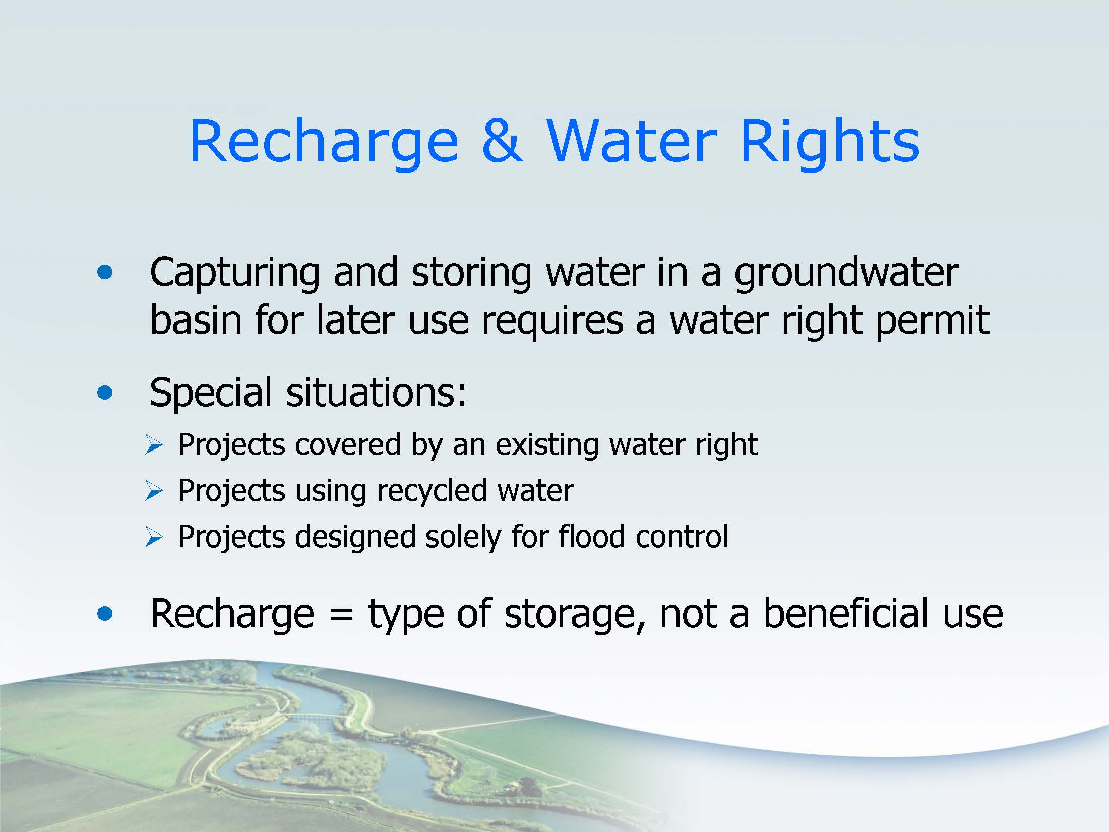 There are several options for obtaining the necessary water right. They could obtain a temporary permit or a standard traditional water rights permit. Depending on the type of water right, they may be able to use an existing water right.
“Water rights like riparian claims aren’t a good fit because they are going to store the water for future use, but if they had a pre-1914 appropriative water right, they may be able to use or change that water right,” Ms. Montgomery explained. “Those changes don’t come to the State Water Board, but still the parties can’t injure others when they make the changes. If the party wants to use an existing post-1914 appropriative water right, permit or a license, they can’t initiate a new right so they can’t go beyond the bounds of the right; they’d also have to come to the SWRCB unless their original project contemplated the groundwater recharge, which it probably doesn’t, so they might have to add beneficial uses, depending on what their original permit or license covered, and they might have to add place of use for where the water would be used. All those changes are possible and we might see parties that do that.”
Another option could be to use transferred water. “If they buy it from a pre-1914 water right holder, that doesn’t come to the SWB for approval, but they can’t injure others,” Ms. Montgomery explained. “If it’s a post-1914 water right, then they do need to come to the SWB to petition for approval through our transfer process. Another option a party could use is recycled water; they wouldn’t need a water rights permit if they are using recycled water, but they should consult with their regional board for all appropriate permitting there. Also if the recycled water is a new source for them that was previously discharged to the stream or will reduce the flows in the stream, they should consult with the State Water Board for a possible wastewater change petition from the Division of Water Rights, because these is the possibility that the reduced flow in the stream could harm other users of the water or the environment.”
With respect to flood control, Ms. Montgomery said that water that’s held temporarily for flood control doesn’t need a water right because flood control is not a beneficial use for water rights. “But that’s assuming that when they are making that diversion for flood control, they are not holding longer than needed solely for flood control,” she said. “If they start to hold it longer for secondary purposes, such as groundwater recharge, they are moving into the territory of needing a water right.”
Ms. Montgomery also pointed out that groundwater recharge for water rights in California is not a beneficial use, so they look at it as a method of storage. “It’s basically the equivalent of above ground reservoir but below ground in the aquifer, so it’s a method of underground storage,” she said. “So the permits that we issue will need to specify how the water will eventually be used, such as by multiple parties that will pull the water out for irrigation or for municipal use, or whatever is appropriate in that situation.”
Temporary permits are different than standard permits; they don’t have as many requirements and are usually issued very quickly. They only last for 180 days, so they are not creating a vested right, but just a temporary ability to divert. They can be renewed if the party requests it. “They can be a good option for a pilot project, so trying out something new is a great fit for a temporary permit,” she said. “Another reason for a temporary permit is if a party is waiting for their standard permit to be approved and they need to divert right away, so they might pursue a temporary permit in that situation.”
The Board has reduced fees for temporary permits for groundwater recharge and storage quite substantially, Ms. Montgomery noted. The fees can usually range from $2000 to $250,000, depending on the amount to be diverted, but the Board has basically reduced the application filing fee to just a couple of hundred dollars, depending on the amount to be diverted. These lower fees have been in effect since December 2015.
The requirements in the water code are less for temporary permits than standard permits. “An example of that is water availability,” Ms. Montgomery said. “Our requirement is to look at the available information on water availability, rather than the detailed analysis needed with standard permitting. We also need to make certain findings to issue a temporary permit, including that it’s in the public’s interest, there’s an urgent need (and urgent need is referring to making the most full beneficial use possible of the water), that there’s no injury to other legal users of the water, such as downstream diverters, and that there’s no unreasonable effects on the instream resources.”
“We also publicly notice the application, which can be done either before or after issuance,” she continued. “That’s in the code, and it recognizes the fact that these are sometimes issued very quickly, and members of the public can file objections.”
Ms. Montgomery recalled how interest in groundwater recharge was picking up in November 2015 ahead of the Governor’s order; the state had been in drought and a big El Nino year was expected, so the water board staff developed webpages with information on how to apply. “The web pages talk about what’s needed to file the applications, the maps, the supplemental forms for underground storage, and the required filing fees. We now have a tips page for people who might file for these temporary permits that walks them through some things that can make the process easier for them; it tells them about early consultations they can do with California DFW to get their involvement, it talks about reaching out to the downstream diverters that might be injured so they understand the project and can hear their concerns early and maybe design the project so that it doesn’t have harm to other diverters. That is on the tips page.”
Ms. Montgomery noted that in April of 2016, they held a staff workshop to solicit ideas from the public and parties that are involved in this issue; their recommendations and feedback is available in comment letters on our website, and they’ve looked through that and filtered that information back into their process. Staff also meets with parties that are interested in filing applications to talk through their projects and see how they can be made to work, she said.
In the 2015-16 water year, there were two applications approved, one for the Yolo County Flood Control and Water Conservation District in Cache Creek, and the other for the Scott Valley Irrigation District in the Scott River. In this water year (at the time of the meeting, early December), three applications were filed; two were withdrawn after discussions with agency staff determined the projects needed to be redesigned, and one application, for Eastside Water District in the San Joaquin basin, was approved.
The Eastside Water District project is located on Mustang Creek in Merced County, a tributary to the Merced River and the San Joaquin River and the Delta. The temporary permit authorizes Eastside to use an unlined existing flood control impound basin to divert up to 570 acre-feet of very high flows. They plan to use existing flood control structures at the existing flood flow levels, and they are going to do a number of actions to cause higher percolation rates in the basin. The project is to use water for irrigation; it is a situation where the District will have the permit, but the water will be used by many parties within their district, so individual well owners will be using the water.
Ms. Montgomery then turned it over to the presentations from the two projects who had received permits in the last water year.
SCOTT VALLEY IRRIGATION DISTRICT
Helen Dahlke and Dr. Thomas Harter gave a brief presentation on the project with the Scott Valley Irrigation District.
Using agricultural fields to recharge groundwater aquifers with storm flows and flood flows has some advantages, such as the fields are usually connected to irrigation infrastructure that can be used to divert the water, and the ability to make use of larger acreages needed to spread available water. However, there are many factors to be considered, such as the crops that are in the fields that are being used for recharge.
The Scott Valley is one of UC Davis’s experimental recharge sites; here the researchers evaluated using alfalfa as a cropping system for recharge. Alfalfa has the advantage of not requiring nitrogen fertilizers, so the risk of leaching nutrients into the groundwater is fairly low. The researchers were also interested in assessing benefits of recharge for instream flows.
 After the permit was received, there were 5 agricultural fields that received water diverted through the SVID infrastructure, as well as a surface pond with a leaky bottom which also contributed to recharge.
They have been doing studies of the effect of water applied during the winter time on alfalfa yields by applying water at different amounts and comparing the yield to the standard plot that only received precipitation. They also measured how much was water was applied and how the groundwater table responded.
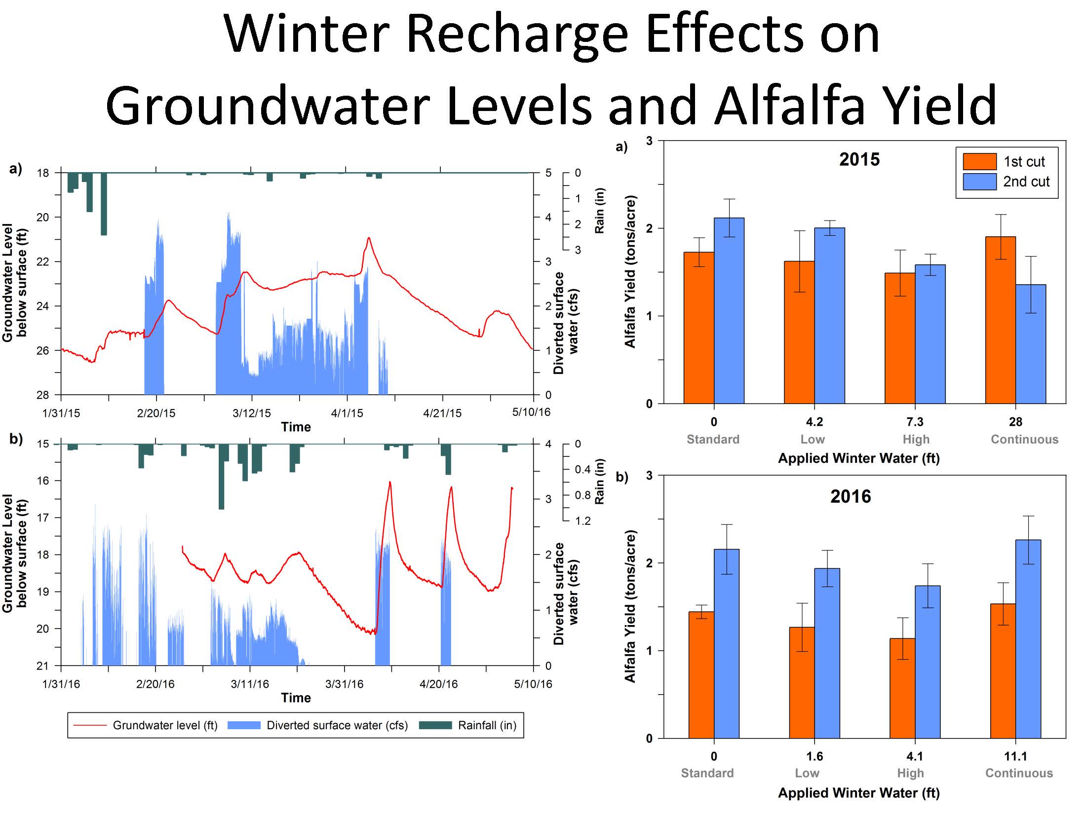 “In response to some of the recharge events, we saw a rise in the water table of up to 6 feet, and so we could see there was a groundwater amount forming under the field,” Helen Dahlke said. “The yield data shows that there is no discernable effect really of the applied water on alfalfa yields; actually this year, we saw that the biomass for the plot that received the most water was more or less on par with the control. There’s one particular field we saw the water table rising within 11 to 19 hours after the water was applied onto the field.”
The water diversion was almost 6 cfs on average over a 2 month period; the Scott Valley River was never below 1000 cfs and at times exceeded 5000 cfs, so it was a relatively small amount diverted for the recharge process.
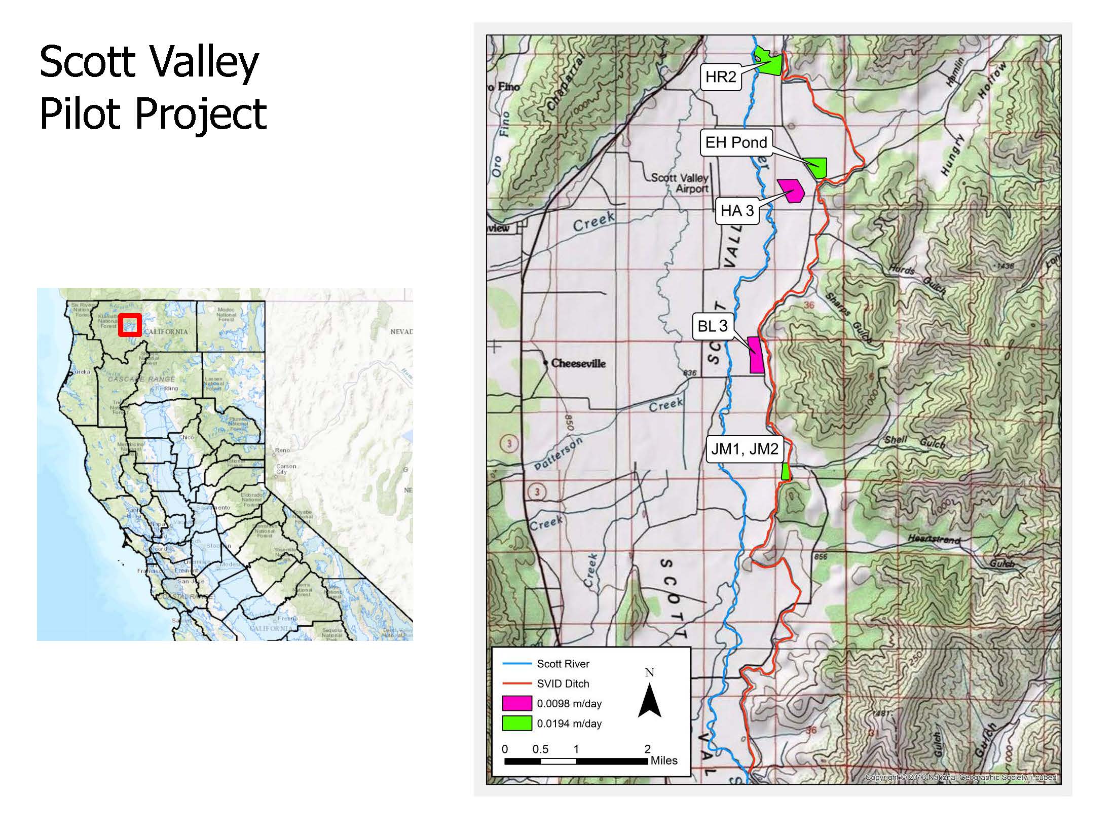 Dr. Harter presented a slide showing the location of the fields, noting that they all are not too far from the Scott River. The color of the fields indicates recharge rate; the fields in green had about twice the rate of recharge as the two fields shown in pink.
Dr. Harter used a groundwater-surface water model for answering the question of what ultimately happens to the water. The Scott Valley aquifer system is mix of sands, loams, and clays; it is not very deep. The groundwater model encompasses the entire Scott Valley; it also is coupled to a model that tracks stream flow.
Dr. Harter explained that stream flow is included in the model; it is input at the edge of the valley where the tributaries and the Scott River flows into the valley, and then the model tracks the streamflow as it moves through the valley and interacts with the groundwater aquifer system. The model can then take also into account diversions, so when the water was diverted, it was taken out of the Scott River, and as a result, downstream from the Scott River, there was an ever so slight decrease in the stage of the river, so small it couldn’t be measured manually because it’s such a small fraction of the overall flow, but it could be tracked by the model. The model also tracked the amount recharged to groundwater, and then tracks where the groundwater will flow, consistent with our hydrogeologic understanding of the aquifer system.
Dr. Harter then looked at what happens to streamflow at the bottom of the valley, noting that there is a stream gauging station in operation since the early 1940s at the point where the Scott River flows out of the valley into the Scott River Canyon. With the model, they were able to predict and analyze what happens to flow at that stream gauging station in response to taking 6 cfs of water at the diversion point; the model simulates the period from 1990 to 2011 and has been calibrated to that period.
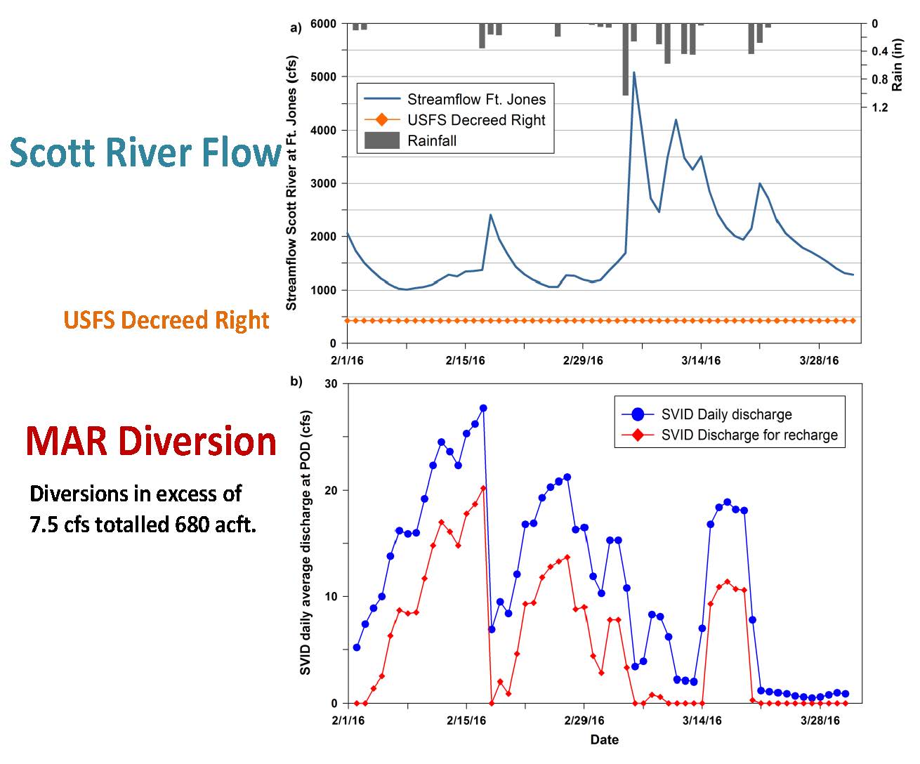 They did two simulations: one with no project and a second in which 5.9 cfs was diverted at the diversion point. “In February and March we diverted 6 cfs showing here as a -6. In red, you see the effective difference in streamflow in the Scott River out of the Scott Valley into the Scott River Canyon. As soon as this diversion happens, we see a decrease in outflows in the Scott River. It is not quite 6 cfs; it’s only about half of it because some of the decreases from the diversion are being buffered by the interconnected stream groundwater system between the diversion point in the Scott River where it flows out of the valley, about 25 miles downstream. So we see a decrease close to 4 cfs initially. As groundwater from that recharge operation flows back into the stream, that decrease in flow rate in the Scott River, itself decreases.”
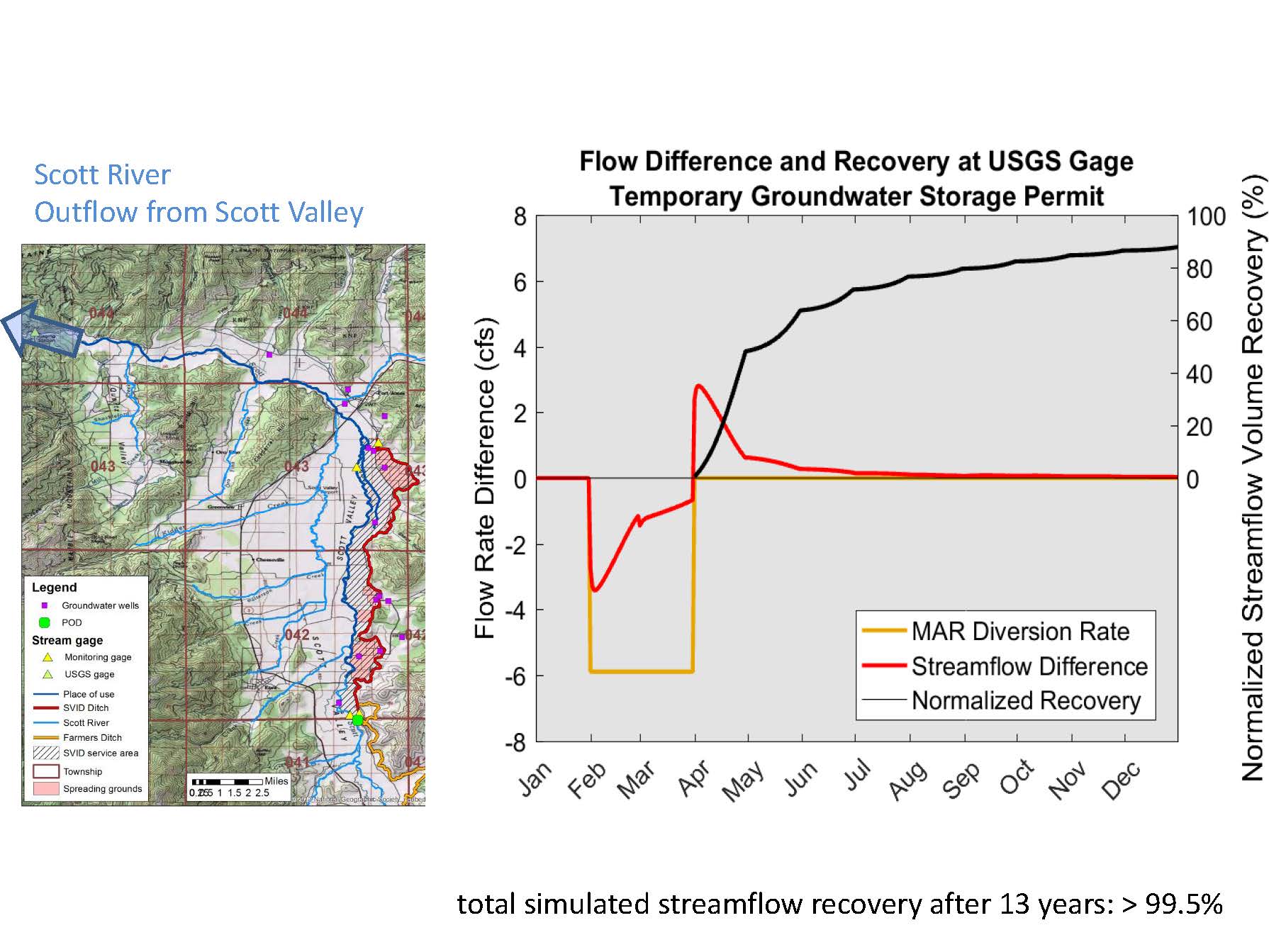 When the diversion is stopped at the end of March, groundwater levels in these handful of locations near the river, causing extra discharge into the Scott River relative to the scenario without the project, Dr. Harter said. “Beginning on April 1st, we actually see 3 cfs more water flowing into the Scott River from these five fields being recharged for those two months at the outflow end of the Scott Valley. That increase also then slowly decreases at an exponential rate as we’re seeing all of our recharged water effectively being recovered by the Scott River. The recovery rate is shown by the black curve. Starting April 1st, we are started to recover water that’s lost from Scott River flow, essentially the area under the negative part of the red curve and regaining that, and by the end of the year, we’ve regained almost 90% of the water that we had taken away from the outflow in the Scott Valley. The remainder then flowing back slowly over the next year and following years at a much, much smaller rate.”
Dr. Harter acknowledged that being a pilot project, it doesn’t really affect Scott River flows from a practical perspective. “It shows in principle the idea behind this, and we can hopefully scale this in the future to larger amounts and couple that with other options for managed groundwater with in lieu recharge and managed aquifer recharge.”
YOLO COUNTY FLOOD CONTROL
Tim O’Halloran, General Manager with the Yolo County Flood Control and Water Conservation District, then discussed the results of his agency’s project.
 He started with a map of the area, noting that the Yolo County Flood Control and Water Conservation District service area is shown in red and the blue is the watershed. The Capay Diversion Dam is a 500-foot inflatable dam that is used during irrigation system for diversion, and that is the beginning of a 160-mile network of unlined canals. The District has been working towards modernizing the system to be able to accept high flows during the winter for recharging groundwater. They diverted water to be used for recharge from Cache Creek into their canal system.
He showed a picture of the diversion dam, noting that the top photo is about 9000 cfs, but it can be as much as 35,000 -40,000 cfs. “There are tremendous opportunities for putting water in the ground for recharging,” Mr. O’Halloran said. “We’ve been modernizing, putting in automatic gates and new infrastructure in to accommodate this recharge. This has been a long-term goal of the District to recharge water during the winter.”


He showed another set of pictures where Cache Creek crosses Hwy 5 at Yolo, pointing out how much water is available there at times of storms.
During the permit process, they agreed to measure water at certain points to ensure that there was always a minimum flow so that no downstream users, riparian or otherwise, would be injured. Another key part of the discussions was who was going to use the water, which would be the landowners in the district. They were able to provide this information due to their extensive monitoring network.
Mr. O’Halloran noted that their unlined canals are part of a sensitive riparian habitat program that’s in place to provide natural habitat, so their unlined canals serve not only as delivery facilities but as recharge facilities and habitat facilities as well.
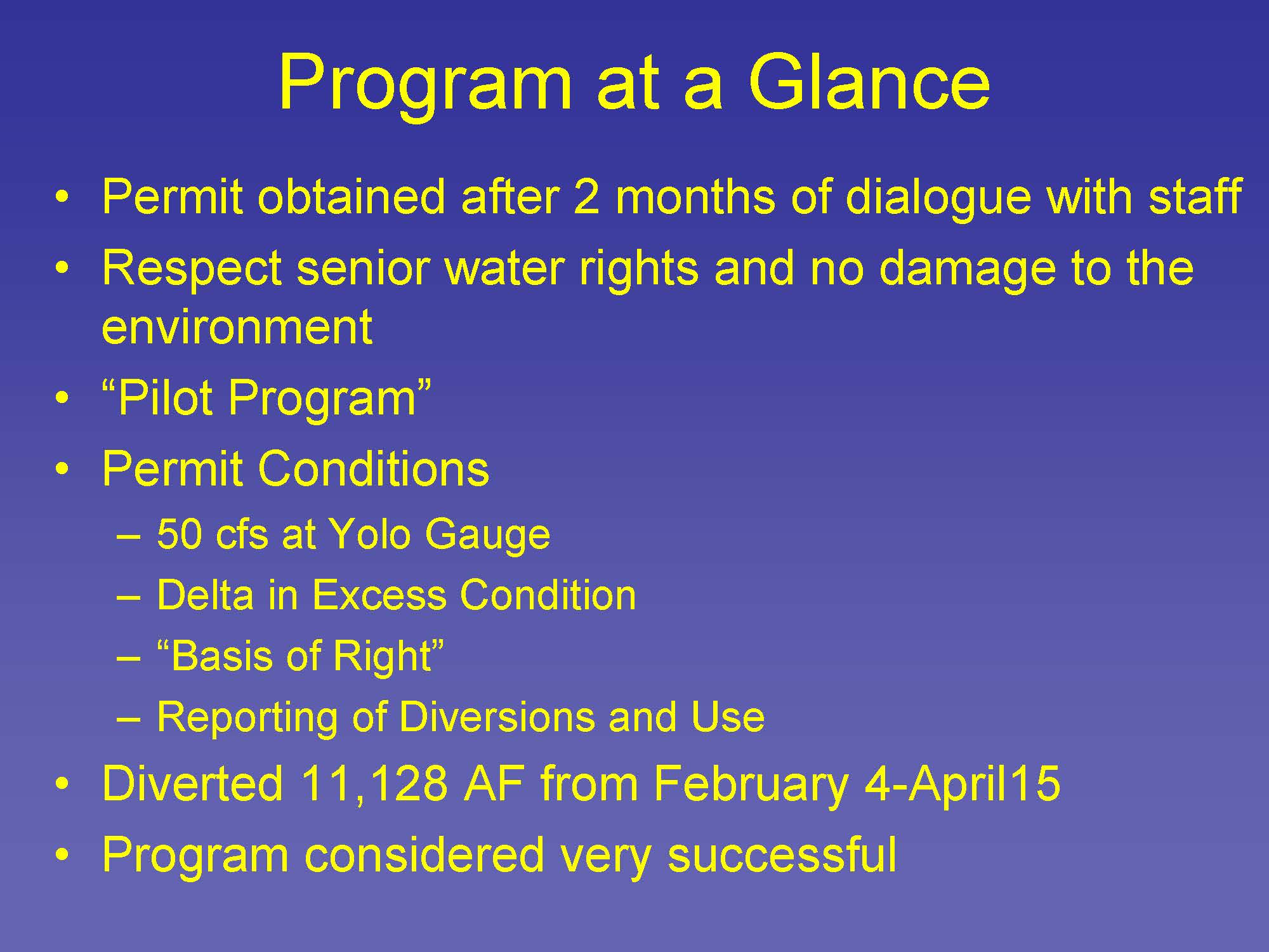 The permit was obtained after two months of dialog with State Water Board staff, which is a short time for the State Water Board. “We worked together really well and accomplished this is a two month period to get this in place while respecting senior water rights and not damaging the environment, we notified all the downstream water users and got their buy in, and we also went to the DFW and talked to them about what consequences it might have, and they didn’t raise any issues at all,” Mr. O’Halloran said.
Over 11,000 acre-feet was diverted between February 4th to April 15th . One of the big questions was determining what was a high flow, which is fundamental to the issue of when to divert high flows. Cache Creek is an ephemeral stream that’s dry nine months of the year. So after considerable discussion, they agreed to set a limit on how much they could take out and how much water had to continue down to Yolo, he said.
Mr. O’Halloran said that this program fits into the holistic program that is already in place in Yolo County with the integrated water management plan and SGMA. “We have a foundational action program in Yolo County that prepared us for this day,” he said. “We have groundwater monitoring, surface water monitoring, subsidence, groundwater modeling – all the tools in the toolbox that made us able to react quickly to the Governor’s order and engage with the State Board staff. We have extensive monitoring, all the dots on there are real monitoring stations within Yolo County so when the question came up where’s the water going to go and how are we going to measure it, we were prepared.”
Mr. O’Halloran then gave his lessons learned:
It’s important to have a robust monitoring system, and to know the landscape and hydrology as each watershed is unique.
Make outreach a component of the plan. “We talked to a lot of people as we were getting this going to make sure we weren’t stepping on any toes or violating anybody’s rights,” he said.
Optimize the system while balancing objectives. “It wasn’t just a matter of opening a gate and letting her rip,” he said. “We spent years developing automatic gates that would allow us to respond to circumstances. We had to take into account construction activities as during the winter is when we do our maintenance and infrastructure improvements. We had to consider debris build up; when you divert high water flow, there’s a lot of debris associated with it. Avoid diverting sediment. … We didn’t divert the peaks, we let it go by because there’s so much sediment. Cache Creek is such an erosive system that we had to let that go by and took the water after the real peaks went through.”
Maximize flexibility to achieve sustainability. “We’re willing to work with the State Board and we’re willing to work with our customers. The university is in our watershed so we want to have a flexible a system and sustainable a system as possible.”
With SGMA implementation, how are they going to accommodate new crops? “We think we have at least a partial solution to this, by diverting water that otherwise is lost to the system,” Mr. O’Halloran said.
SUMMARY OF THE PROJECTS
Sarah Sugar, an environmental scientist in the permitting and licensing section, then summarized the two projects.
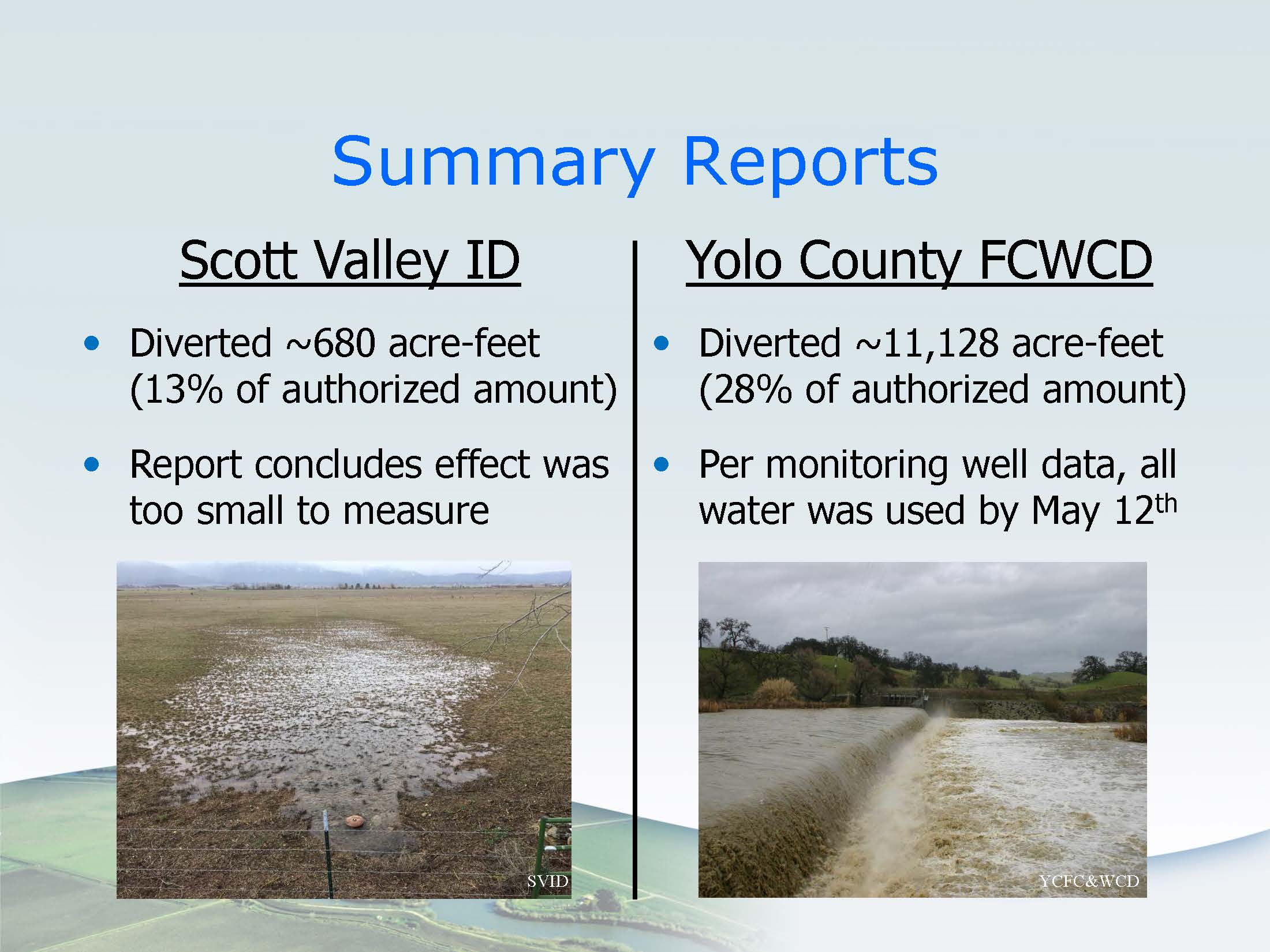 Both the Scott Valley Irrigation District and Yolo County Flood Control submitted summary reports in late September, early October as required in their temporary permits; the summary reports described how much water the permittees diverted, how much water was put to use, and how they measured or estimated beneficial use.
The Scott Valley Irrigation District diverted around 680 acre-feet, or 13% of the maximum they were allowed to divert. The amount is smaller because the Scott Valley had above average rainfall last winter, and the delivery canal had already accommodated extra runoff and other legal winter diversions; that sometimes left limited capacity for diversions under the temporary permit. Also, some landowners were hesitant to add additional water for recharge when their fields were already soaked from precipitation events. The amount of additional water returning as base flow to the Scott River was too small to measure, so instead they relied on estimated numbers based on modeling data. According to the model output, some of the water returned while they were still diverting water; about 45 acre-feet of water returned between April and July, and approximately 90% of the water will have returned by the end of this year.
Yolo County Flood Control and Water Conservation District diverted approximately 11,128 acre-feet or 28% of what they were allowed to divert. They were allowed to use agricultural lands but they ended up only using their unlined canal systems for this project. Diversions were sometimes limited because of runoff in the canals, water turbidity, permit conditions, and storm forecasts. Based in 11 monitoring wells in Yolo County Flood Control’s district, more than 13,000 acre-feet of water, or more than they diverted, had been withdrawn in the district’s service area by May 12th, and they calculated this using the average drop in water table levels over their service area.
QUESTIONS AND RECOMMENDATIONS
While processing the applications for these projects, there were some questions that came up for how to process and structure permits for groundwater recharge. Sarah Sugar and Darren Tran then ran through the questions.
Question #1: How should permittees account for beneficial use?
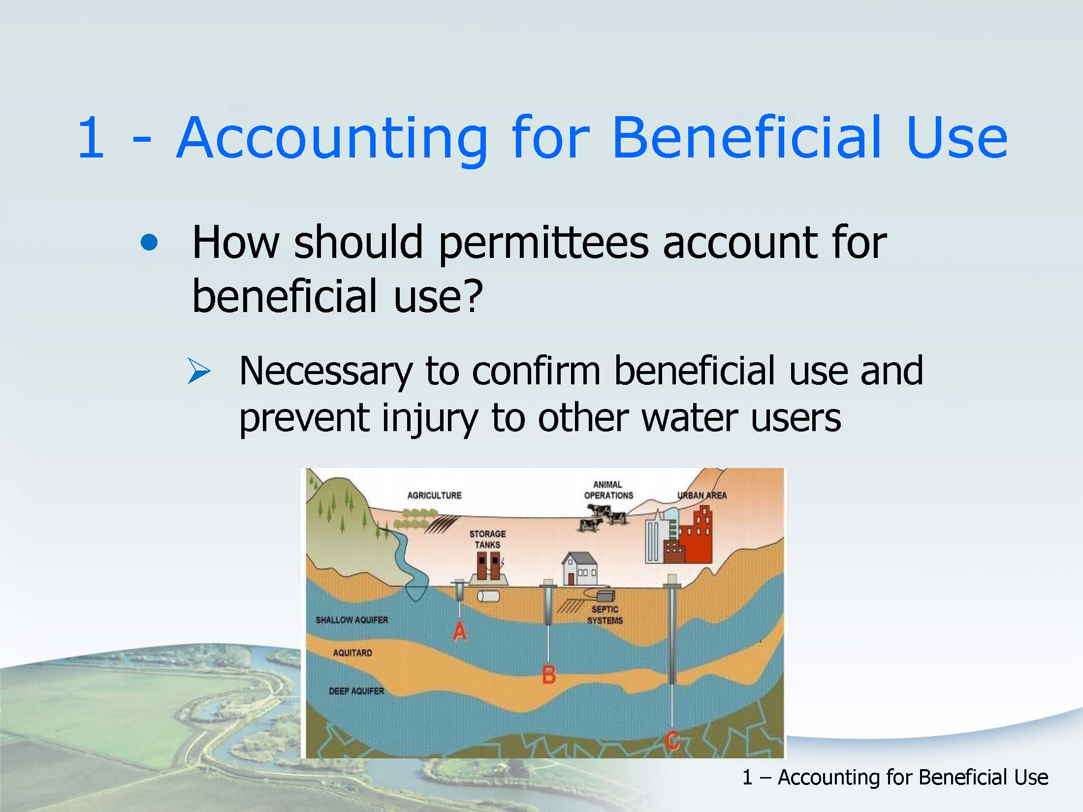 Water appropriations are linked to some beneficial end use, like irrigation or municipal use; when the beneficial use of the water ceases, the right ceases. Accurate accounting and reporting helps ensure water isn’t wasted and that the diversion doesn’t injure other legal users; but for underground storage, this accounting isn’t always straightforward, Ms. Sugar said. She noted that the figure here gives an idea of a few of the different influences on inflows and outflows in groundwater basins, such as pumping in different locations at different depths, and connections to surface flows.
“The challenge we had is that some projects may have trouble measuring or estimating how much water is pulled out of storage under the permit or how much water has been lost from the basin,” she said. “For projects with many small users, water may be pulled from individual unmetered wells, making it difficult to measure and report how much water has been used under a particular permit. Accounting can be especially difficult in groundwater basins that haven’t been well studied.”
“Many basins naturally lose some water to surface streams, adjacent basins, evaporation, overlying vegetation, and water stored in these basins under a water right permit would experience similar losses,” she continued. “If the losses in the basin aren’t well understood, the permittee or the division may overestimate how much water remains in storage under a permit, particularly if the water is stored for a long period of time. This in turn could lead to withdrawing more water than the user has a right to, potentially causing overdraft and injuring other groundwater users in the basin.”
Beneficial use for some types of projects can’t be directly measured. Ms. Sugar noted that a good example is Scott Valley Irrigation District’s case where the objective of the project was to increase flow in the Scott River by raising the water table near the channel.
The two projects used two different methods of accounting for beneficial use: the Scott Valley Irrigation District used their integrated groundwater surface water model, and the Yolo County Flood Control assumed no losses and relied on water level data from their network of monitoring wells, estimating the amount of water put to use by measuring the local drop in the water table. There were no plans for long-term storage or increased pumping for the Yolo project.
“However, not all regions currently have basin-specific models or networks and monitoring wells for projects to rely on,” Ms. Sugar noted. “Some of these data gaps will likely be filled by implementation of SGMA. SGMA requires non-adjudicated medium and high priority basins to develop groundwater sustainability plans by 2020 or 2022. These plans are required to have a conceptual model of the basin, information about the basin’s structure, and water budget, among other things. The plans must also identify potential areas for recharge.”
Groundwater sustainability agencies might want to plan ahead and include an accurate accounting approach for artificial recharge in their groundwater sustainability plans. “In the meantime, the accounting approaches we accept will have to depend on the size of the project, the duration, and its purpose.”
Question #2: How can beneficial use be tracked for permits issued to water purveyors?
 Another question that arose is when the parties submitting an application is not the party that will actually be using the water. This was the case for Yolo County Flood Control’s project, as well as Eastside Water District. The districts were the permittees, but the users were private well owners within the district’s service areas.
“However, parties with private wells usually already pump water from the basin under an overlying groundwater right, and in some cases, pumpers may want to continue to pump water under their groundwater rights instead of under another party’s permit,” said Ms. Sugar. “Reasons to do this can include defending against a claim or prescription or preparing for basin adjudication, or development of a groundwater sustainability plan. So applicants who are not themselves using the water will need to clarify how to identify water used under their permit.”
“Double counting water under multiple rights can complicate basin management and future adjudications,” she continued. “This issue can also effect whether a particular accounting approach can be used for demonstrating beneficial use. Some basin-wide accounting approaches can only estimate overall pumping in an area, so separating out pumping done under a particular permit from all local pumping can be difficult.”
The Yolo County Flood Control and Water Conservation District addressed this by passing a resolution allowing their customers to use water stored underground under the permit; the Division decided this solution was acceptable for the particular project because the permit was temporary, the water would be used quickly, and the users were already surface water customers of the district.
“However, the cleanest approach for separating out water used under a permit in these situations would be to require explicit agreements between the permittee and water users,” she said. “This was the approach we used for the recently issued temporary permit for Eastside Water District where the users aren’t surface water customers of the district. Groundwater sustainability agencies may be able to simplify this requirement by maintaining accounts of pumpers use under different rights or through other means in their plans.”
Question #3: How can the Division quickly determine water availability information for temporary permits?
 The objective of determining availability of water for temporary permits is to make findings that there is no injury to other legal users of water, and no unreasonable effects on fish and wildlife. These findings also apply to a standard permit; however, under a standard permit, it is a requirement that the applicants must demonstrate that an appropriate water is available to supply the project. Under the temporary permit, it is not a requirement, but staff would need to review available records and any information that relates to the availability of water before approval.
“Generally a project proposing to divert only during high flows have a lower risk of causing injury; however, there are challenges with this approach,” said Darren Tran, staff engineer. “The Governor’s order directed the State Board to prioritize temporary water rights and to accelerate approval for projects that enhance the ability for state and local agencies to capture high precipitation events for local storage and recharge. Some people may interpret high precipitation events as a wet season or a wet year. Staff initially interprets high flow associated with storms, and this is one of the challenges we are continuing to work through.”
“The other challenge is that even high flows may already be allocated to downstream senior users or provide an important ecological function for fisheries, for example flushing wood debris and sediment movement. Temporary permits may also be issued in stream systems classified as fully appropriated where risk of injury may be higher.”
To complicate matters, not all applicants seek to divert high flows. “High flows carry higher loads of fine sediments that reduce infiltration rates in recharge areas and in lined ditches,” he said. “Some applicants propose to divert just above the base flow and avoid diversion of high flows.”
Given the complexity of water rights and diversity of stream systems, staff have not been able to identify any universal protective threshold that could be used to distinguish high flow from other available flows. “As was done with Yolo County and Scott River project, the division will continue to evaluate projects on a case by case basis,” Mr. Tran said. “Depending on the stream system, projects diverting high flows or flood flows would usually present a low risk of injury, therefore making findings could be easier.”
He said they would continue to prioritize projects consistent with the Governor’s order; once the order is lifted, the Division will prioritize permits using our existing prioritization criteria. The Division gives priority to projects that are of statewide significance and to projects designed to minimize or avoid impacts to the environment, he noted.
IN CONCLUSION
Amanda Montgomery said they’ve seen a fairly low number of filings so far. “The Board has substantially reduced the application filing fee for these types of projects, CEQA suspended for the local and state agencies who want to pursue them, and that Board staff stand ready to meet with parties that are interested to try and work through their projects and find a way forward.”
“What we’ve learned so far is that at the very beginning, we thought we might be able to find some broad ways to move these things forward,” she said. “We thought it’d be easy to say what water is available on a broad basis and say what protective conditions to put in, but what we really found is that we have to look at them on a case by case basis. You heard that today from both the projects, that in their situations, maybe what we think they might come in with is different than what they come in with, and we just have to look at what the situation is for that individual watershed and what they are planning to do and work with parties moving forward, and that’s what we plan to do as we have future projects this year and in coming years.”
FOR MORE INFORMATION …
- Click here for the State Water Resources Control Board’s webpage on groundwater recharge permits.
- Click here to watch this presentation on webcast.
 Sign up for daily email service and you’ll never miss a post!
Sign up for daily emails and get all the Notebook’s aggregated and original water news content delivered to your email box by 9AM. Breaking news alerts, too. Sign me up!
