


Adapting to uncertainty or novelty during accelerated climate change
In recent years, many tidal wetland restoration projects have become larger and increasingly becoming more than just a mitigation tool. Tidal wetland restorations planned or under construction now face major new uncertainties such as accelerated climate change and sea level rise, invasive species, a decline in sediment supply, and other factors that now require revisions of our earlier assumptions about tidal wetland restoration.
Dr. Peter Baye has a long history of working on regulatory wetland restoration projects in the San Francisco Bay. He’s currently an independent consulting Plant Ecologist specializing in endangered species recovery, wetland restoration, invasive plant management and native vegetation management. In this brown bag seminar, Dr. Baye takes a look at past wetland and marsh restoration projects, and discusses what can be learned from the successes and failures of those projects, as well as what is needed in terms of monitoring restoration projects into the future.
“What I want to try to do is highlight my professional experiences and sometimes frustrations with monitoring, having seen the difference between what it can be and what it actually is, and try to encourage it to evolve from the era where I got my start which is that the permit driven era of wetland regulation where permit compliance and project performance were pretty much the gold standard, especially for smaller projects,” began Dr. Peter Baye.
 “I lived through the era of expansion of wetland restoration projects to these large scale regional projects, and I noticed that there was still a lot of inertia,” he said. “There are lag effects that are both institutional and some might even by subconscious about how we view what proper monitoring is, as it originates from this very early era of evaluation, grading, and proving that you deliver what you’re supposed to deliver, orientation for early wetland restoration monitoring.”
In the early 1990s, the Army Corps of Engineers came up with the first standardized guidelines for what every monitoring plan should have and even if that is no longer actively used, there may be later generations of it, he said. “I think that same approach of wanting to standardize things and have it be something that uses a template to prove quality control, which is sort of a Corps of Engineers engineering stamp of approval. I think that is still with us and it can be limiting for how we can learn.”
The other end of the spectrum of is research and a lot of project-oriented monitoring, and resource agencies don’t want to go towards research, Dr. Baye acknowledged. “Somewhere in between is in that realm of adaptive management where you could integrate the ability to show that your project is performing and your natural resources are being managed properly while you’re also learning and applying the most invaluable lessons which may not be based on your goals and objectives,” he said.
Dr. Baye gave two examples: “One is Montezuma Wetlands, one of largest wetland restoration projects of its decade which was the 1990s. It’s a good illustration of a project that came into conception and permits in one era and is still waiting to be reached. Getting closer, but it’s a good illustration of that lag. Its design permitting, planning and monitoring is definitely mid 90s and that’s definitely the permit era. At the other end, Sears Point, breached recently, had a much more rapid planning and evolution period. This illustrates juxtaposing these that lag is not just a metaphor, it’s a real thing; and a lot of our project planning is a mix of cutting edge adaptive management oriented science informed by current research and stuff that we’ve inherited from quite a while back.”
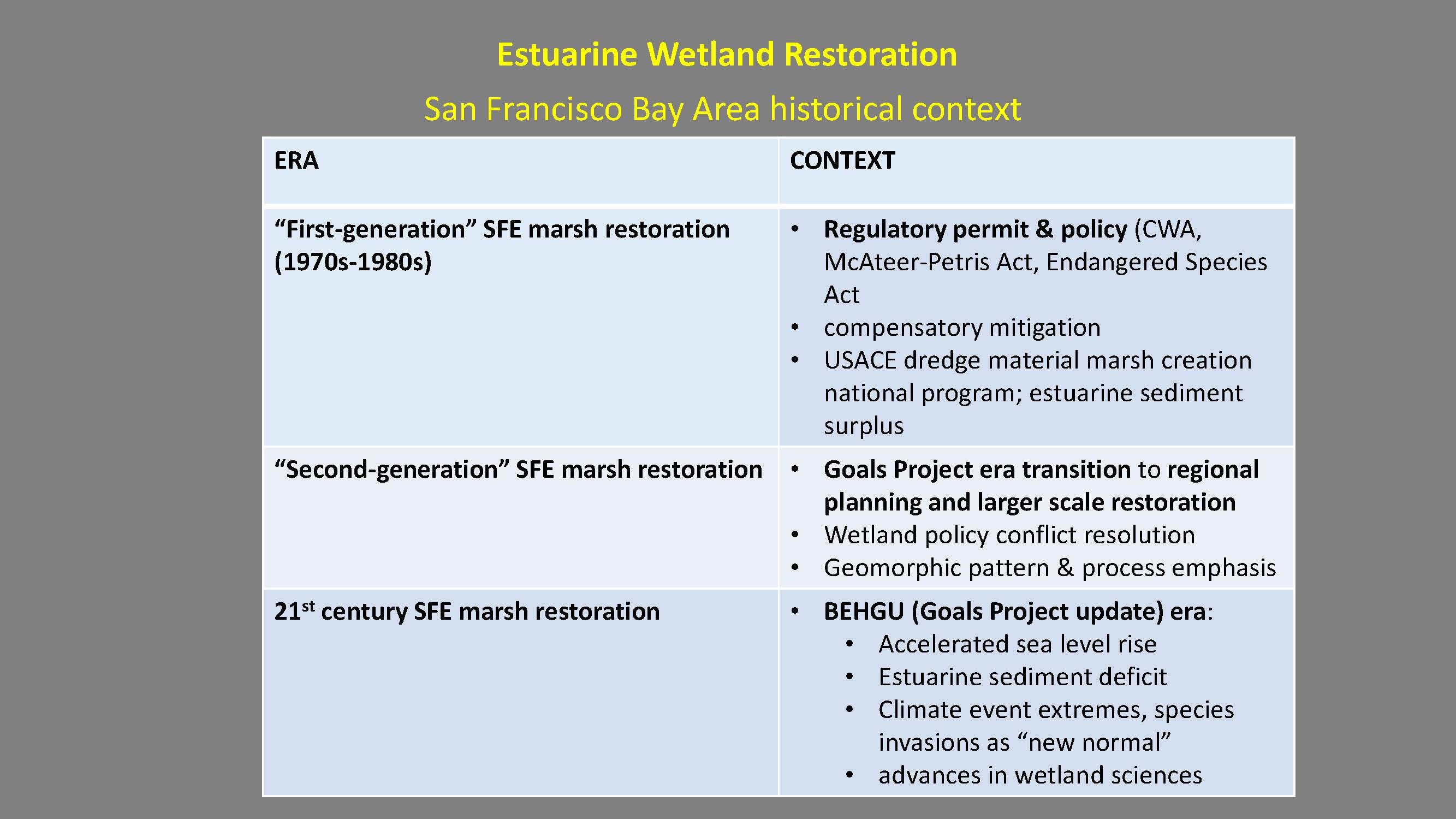 Dr. Baye presented a slide showing the evolution of monitoring and reporting. “The earliest stages of monitoring and reporting were based on that first generation of San Francisco estuary restoration projects, which were pretty much driven by permits, particularly BCDC McAteers-Petris Act and the Endangered Species Act that show that you were compensating for your impacts – sort of a quid pro quo, offsetting impacts and compensatory mitigation. Most of the methods at that time which drove monitoring were placement of dredge material. They were an off shoot of the East Coast Corps of Engineers dredge materials management program which was to find a benevolent place to put dredge material. So the monitoring was focused on sediment accretion, reaching target elevations, errors of tolerance and showing that you have vegetation cover – just the most rudimentary kind of ecology.”
The second generation coincided with the earliest stages of articulating standard monitoring plans. “This is the era where the San Francisco Estuary Institute’s habitat wetland habitat goals project was starting to get coalitions of scientists to articulate what the next vision should be for restoration; this also informed monitoring. This is an era when geomorphic processes as well as some ecological processes began to dawn into consciousness and began to get incorporated in to some extent in monitoring plans.”
“Now we’re to a point where we’re dealing with very changed baseline conditions,” he said. “This is the Goals Project Update Era, where the backdrop for monitoring plans is a sea change in sea level rise acceleration; we are above all of the late Holocene average rates. We are undergoing step changes in sediment supply going from transport-limited sediment supply to restoration sites to supply limitation. And we’re now experiencing an accelerating rate of climate event extremes, including El Niños, that cause very rapid short term increases in sea level that are coming at a greater pace and a greater magnitude. These are affecting restoration projects right now.”
There have also been advances in wetland sciences that are changing the way we understand the past, Dr. Baye said. “The norm for most restoration projects in the last decade or two have been based on historic ecology – a documentary record that extends about 150 years. That was considered the baseline or the standard for the design for the restoration project and our monitoring often, intentionally or not, was based on gathering data to show how closely or how faithful you replicated those presumed historical conditions or natural conditions.”
“We now have an expanded view of the past that really has not yet been incorporated in our goal setting or monitoring plans for restorations,” Dr. Baye said.
He then gave some examples:
Examples of first generation marsh restorations are Pond 3 Alameda and Muzzi Marsh. “These are the most mature restoration projects we have and they provide some instructive background on what we’ve missed with monitoring,” he said.
The second generation (1990s era) of San Francisco estuary marsh restoration includes Sonoma Baylands, the Hamilton Wetland Restoration, and the Montezuma Wetlands. “In many ways, these are the products of lessons learned that did not come from the monitoring of that first generation. They were learned indirectly from things that escaped monitoring, because some of those early projects had unexpected outcomes. And the monitoring plans were adapted to what they expected and what the predictions were, rather than alternative hypothesis.”
With the current generation of projects (2000s and later), there has been a proliferation of large scale projects, such as Sears Point, Aramburu Island, Cullinan Ranch, and Oro Loma. “Those are looking at variations of marsh restorations along the estuary that are a little off brand. Not all of them are tidal marsh meadow or tidal marsh platforms. Some of them are now shifting to restoration along the edges of the estuary, fringing marsh and super tidal transition zones above them, partly in response to increasing emphasis of sea level rise and sea level rise adaptation. So there is greater diversity of marsh types and greater diversity of the method by which to restore them and there should, therefore, I suggest therefore be a greater diversity of the monitoring plans that capture the information they generate. But we haven’t quite seen that yet.”
The origins of monitoring and the emphasis of monitoring in the 80s had to do with permit compliance, Dr. Baye said. Monitoring emphasized things such as suspended sediment deposition rate, mudflat/marsh surface average elevation, threshold for pioneer (low marsh) vegetation establishment and acreage net gain, and channel formation.
“It was performance monitoring. The landscape context was very limited. The restoration site itself was the universe of the monitoring. Most of the restoration projects were within breached dikes and the monitoring dropped off beyond the edge of that dike. They’re largely marsh platform monitoring programs. Edges might get just to the high tide line, but the universe just sort of falls away. We now understand that the environmental settings very strongly influence the restoration sites and vice versa. Now that we’re working on a much larger scale of restoration, the restoration sites themselves are changing in both the physical and biological environments that they’re placed in.”
“Our assumptions about the way these marshes evolve guides the way we construct monitoring plans,” he said. “We are simplifying engineering assumptions so we can build restorations sites, and that tends to simplify the monitoring, but it can also constrain the range of phenomena that we can detect with them. Most importantly, all of these early monitoring plans from up through the 90s and into the early 2000s have deterministic assumptions. They are based on linear processes and progressive change; the idea of alternate ecosystem states or ecosystems that alter their trajectory, get stuck in another mode or switchback – that really wasn’t part of the science, nor was it part of understanding the deep past of marsh restoration.”
 We’re starting to see some of the uncertainties in the evolution of those second generation projects. “There are a lot of surprises in the little twists and turns they take,” Dr. Baye said. “Some of the changes that we see in restoration sites are not anomalies that are part of the pattern in process of marsh evolution effected by events, not progressive linear predictable changes, but stochastic processes – El Nino events, major floods, prolonged droughts that temporarily shift extremes of salinity, or the timing of rainfall that plants have their seedling germination cued to. That can leave imprinted effects on the way marshes evolve.” He noted that the 90s drought, the big El Nino event in 1997-98, and now the current drought all have left their imprints on restoration projects, but not necessarily the monitoring plans.
Even pre-project site water management caused irreversible soil and substrate changes to restoration site that affect the outcomes, he noted.
Rapid invasions of invasive species is another factor most restorations have not accounted for. “Some restoration projects are not just set up to detect invasive species coming in to the sites, and some projects are actually generating populations of invasive species, but because that’s not [part of the permitting process], we’re not really setting our monitoring plans up to detect the invasions that we actually generate.”
“These are uncertainties that have not yet made it into the norms of monitoring,” he said. “Ecological surprise is sort of the overriding theme that monitoring needs to incorporate. We’re got a lot of experience reporting on what we expect and reporting how well we’re meeting standards. We are not good at keeping track of unexpected.”
Dr. Baye then presented slides from PWA’s Tidal Marsh Restoration Guidelines, which he said was the state of the science up to about 2004. “It encapsulates a vast body of very valuable professional and scientific restoration experience primarily in the South Bay and North Bay that’s based on a tidal breaching sedimentation and achieving accreting marsh platforms. It illustrates the underlying assumptions of the way marshes form and how it affects monitoring.”


He noted that the charts depict a linear process where there is progressive change, declining over time, and suspended tidal sediment accretion to critical thresholds of ecological change. “This is sort of a textbook approach where there is a breach, mud comes in, it accretes faster, it slows down and you reach a target elevation that becomes the threshold that you monitor for. Then you’re supposed to reach a dynamic equilibrium where you don’t really have to monitor much anymore because you’ve reached that steady state. That’s the simplifying assumption and there are nuances for it.”
“It all is very predictable, more or less a linear process and some of the perturbations, very few identified, like wave energy that can change the rate or the timing of the process, but they’re all sort of driving toward equilibrium and this dictates what you should be monitoring: wave energy, suspended sediment concentration, and accretion,” he said. “But it’s all based on the assumption that all you need to generate is a marsh plain; there’s nothing about the edge, nothing about the horizontal change, nothing about biological diversity, and nothing about the processes that drive restoration other than suspended sediment deposition and to some extent, channel formation.”
But here’s the long term reality, Dr. Baye said. “Those models are based on the 20 or 30 years of breached dike restoration projects, but here is some of the more recent research about the actual South Bay Salt Marshes that formed on their own, showing that one of the simplifying assumptions we have about linear change and progressive succession just isn’t true.”


Researchers at UC Berkeley have looked at sediment cores throughout the South Bay, after a decade of work in the North Bay. “No one had looked at the ages of marshes in the South Bay,” he said. “It turns out, they’re not very old. Most are just a few hundred years old. The oldest may get to 1500, and they have a very unsteady history. You can see at the bottom of the cores, there’s a lot of rapidly accreted bay mud. Some of them go through typical succession where it’s low marsh, core grass and then you see the evolution to high marsh, you see it flip back to low marsh. Sometimes it flips back to high marsh, then low marsh. Unsteady state. Non-equilibrium conditions. Fluctuating or alternative stable states. By stable, I mean persistent. These cores reflect hundreds of years.”
One of the other findings that is relevant to monitoring is that many of the marshes that we have are artifacts of a little ice age where there was rapid pulses of sediment causing a disequilibrium condition and marsh expansion over tidal mud flats that hadn’t existed before in the Holocene, which was followed by rapid sort of correction, he said. “That’s very different from our monitoring that’s safely confined behind dikes so you don’t have to monitor the universe beyond the dike and all that you looked at is vertical change. Now we know that that is not a safe assumption. These cores tell us to be looking over deeper periods of time and we should be looking for these thresholds. These changes are inflection points. These are things you should at least expect as an alternative hypothesis for how a restored marsh should change.”
 A fluctuating, non-steady state for marshes seems to be the norm, he pointed out. “There’s not one core that shows really simple progressive change along that mud flat low marsh to high marsh,” he said. “If it occurs, it’s got to be the exception … In North Bay at China Camp, we’ve studied China Camp for ages without equilibrium channel and cross section channels in relation to tidal prism. But if you look at the core at China Camp, they show alternation of estuarine open bay mud, peaty muds, marsh reversion to Bay mud, peaty cores, missing layers, sand layers – at least five sand layers showing mega floods or deluges with terrestrial inputs into extensive areas of marshes. These processes we kind of locked out our field of view and as we look towards the long term future of tidal marshes, we probably need to accommodate the full range of processes, particularly the extreme climate events that appear to be associated with certainly the sand layers.”
“These cores don’t really tell you too much about horizontal change,” he said. “But it does suggest that horizontal instability changing outer marsh shorelines may be an important part of long term marsh change. But we kind of block that out almost administratively because we’re working mostly behind dikes.”
He noted that at China Camp, there are pollen signatures that correspond to salinity indices based on the number of physical parameters like isotopes and biological indicators that show major salinity fluctuations at the different time scales. “It’s gone from kind of this historically unusual condition of pickle weed dominance to periods of prolonged brackish marsh that would be expected in places like San Pablo Bay. Pickle weed was ascendant for long periods of long drought, but there were low periods where basically China Camp went to a brackish marsh. So setting goals and monitoring based on a presumed single climate driven outcome is probably misguided. The norm for these long-term marsh evolutions seems to be a lot of fluctuation.”
 The Goals project has brought in a whole new suite of concerns about marsh restoration that have not necessarily made their way into the current generation of monitoring plans. “We focus most of our monitoring efforts on marsh platform evolution, the marsh plain and low marsh. We’re only now starting to emphasize the monitoring of marsh edges as we design more marsh edge and place more resources at the edges, the transition zones and also the eroding edges, the bay edges – that may become more of the need for allocating monitoring resources.”
The other focus of the Goals project that should inform monitoring in the future is focusing on those limiting habitats for the goals we are going to go forward with. “A lot of the biological diversity conservation of tidal marshes is not uniformly distributed,” he said. “If we’re spending most of our resources monitoring marsh platforms, and if most of the species are limited by only a portion of that marsh complex and not the middle part of the marsh, but the edges, either the channels, channel banks, the levees and the transition zones … maybe that is an indication of the need to reallocate monitoring form this sort of broad comprehensive marsh platform prospective ending of the dikes to where the critical habitats are.”
Another emphasis from the Goals project is the importance of local watershed connections – not just ambient background salinities or total freshwater flows or total nutrient loads, but what local watersheds deliver to local marshes and restored marshes in terms of sediment yield and local freshwater discharges, both surface and sub surface including groundwater, Dr. Baye said.
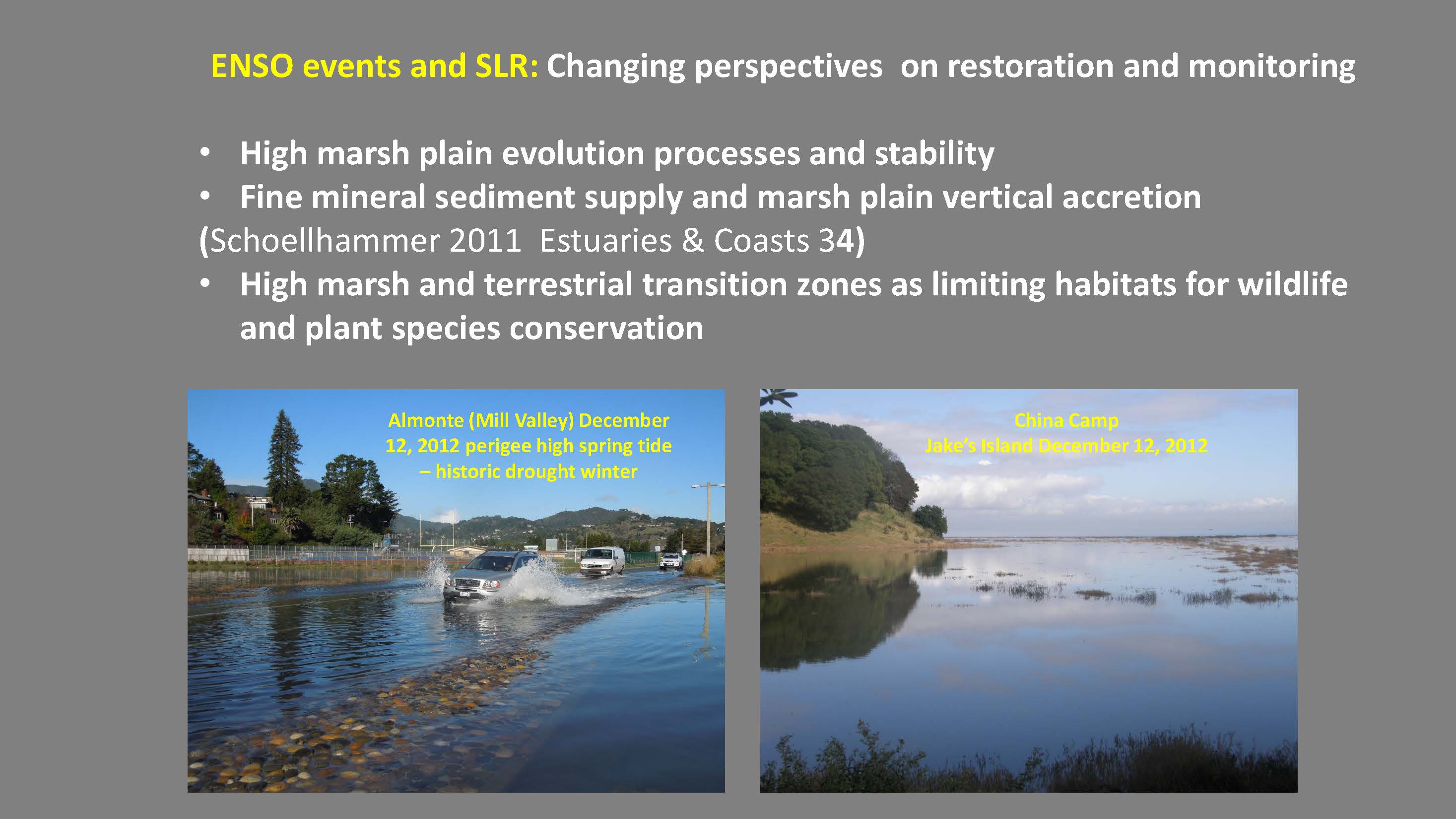 He presented some slides to illustrate the point. “High marsh plain evolution instability really doesn’t account for those limiting factors during those extreme high tide flood events which provide the key mortality vulnerability episodes for a lot of the species that we’re restoring these marshes to conserve,” he said. “This is calm weather El Nino event in 2012, about over a half of foot over predicted tides … almost a foot of water over the road. These events, which are not predicted, leave absolutely no high tide cover for resident marsh wildlife. There’s a lot of marsh restoration in the Mill Valley area, and most of the projects are no longer monitored because they were presumed to have achieved their final equilibrium. They’re being shifted and the marshes on the bay side of this flooded road are actually shifting back to cordgrass. Many had been pickle weed for decades and now we’re seeing—during the brief El Nino episodes, it being driven episodically back to cordgrass.”
At China Camp, one of the most mature marshes and one of the highest marsh plains, is now continuous open water surface under non-storm conditions. “This has nothing to do with storm surge or low atmospheric pressure; these are just high sea level stands of El Niño’s on top of perigee high tides. … The entire levee is submerged at high tides, under about six inches of water and the top of it is salt grass. These are things that have been pretty much assumed to reach some kind of equilibrium or gradual rise at sea level over long periods of time. But the El Nino events are changing all that.”
One of the key species for marsh restoration and monitoring are Ridgeway rails and clapper rails; the limiting factor for those species in tidal marshes is often mortality events during high tides. “Unfortunately, most of the monitoring effort for these clapper rail-driven or Ridgeway rail-driven marshes is on the general evolution of the marsh platform and channels that provide the presumed stable background,” Dr. Baye said. “This is the clapper rail marsh now completely submerged at high tide. There’s no internal cover – all the gum plant, all the higher pickle weed is under about a foot of water.”


This was actually a pretty successful project, Dr. Baye said. “But things are changing fast so now there’s zero cover within the marsh and the territories of Clapper rail. Clapper rails are sort of roosting at high tide on top of rocks walking back and forth attracting predators.”
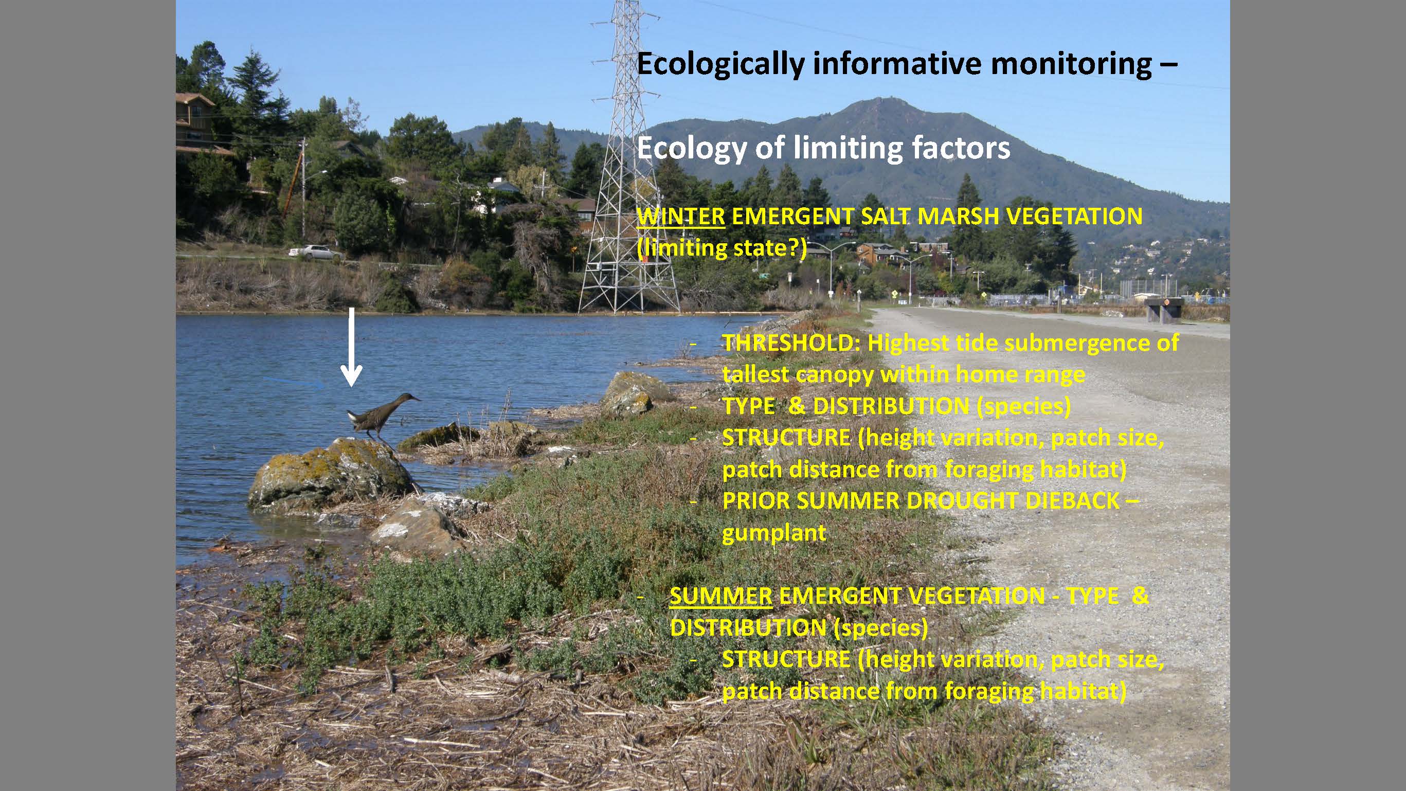 So if you are allocating monitoring resources, what should you be allocating it towards? Should you be focusing on marsh plain accretion? “Maybe we can live with less information about the average conditions in the marsh plain and focus on the limiting factors. The thresholds here are the winter emergent salt marsh cover. This shows a very different situation which indicates that you can’t use a standard monitoring protocol that fits the whole estuary. The threshold clearly is the highest tides of the year that cause significant submergence of the canopy and the distribution in types of that high cover within the marsh complex. It’s not enough to simply map the vegetation types and say where here’s the map of gum plant that would provide that cover. You really need to know more about the structure of the high marsh and particularly gum plant in this case.”
Dr. Baye pointed out that after three years of drought, all the gum plant in this entire system has pretty much been reduced to skeletons. “It’s still present … but the high tide refuge is pretty much knocked out by the drought and that’s true in most of the South Bay marshes I visited. Only the youngest plains are retaining cover so even the reliance on gum plant as high marsh cover, so this is something monitoring plans need to pick up.”
In the 1980s, there was the ‘real’ salt marsh and then the peripheral halophyte zone that was only considered useful as long as there’s some sort of crude cover. “But the dynamics and structure of that peripheral halophyte zone may be one of the most important factors we have for conserving the listed species for which the restoration projects and their monitoring was dedicated,” he said.
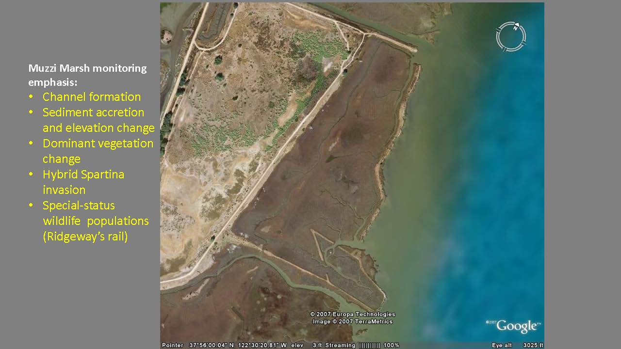
 In the Central Bay, South Bay, and North Bay, monitoring parameters are based on gum plant. He pointed out in the pictures, he drove ahead of the tidal wave and compared Rush Ranch and Suisun marshes. “Muzzi marsh (center picture) is one of the oldest most mature tidal marshes,” he said. “The entire interior surface is built on dredge material to elevate the platform, and because of the vegetation structure, it’s completely under water. I don’t think it’s actively being monitored now.”
“But exactly the same tide a few hours later for the wave to propagate up in a different vegetation structure – this is also a prehistoric marsh,” he said. “You can see that not only is the high marsh plain cover because of the vegetation structure providing ample uniformly distributed canopy cover, but the low marsh is dominated by these bull rushes and the low marsh provides higher cover than the high marsh. It makes you wonder about why we emphasize monitoring high marsh elevations. It made sense in salt marshes, but does it have the same species conservation impact in Suisun marsh. Probably you need to adjust priorities of monitoring plans for restoration based on vegetation structure and that’s not yet done.”
The Department of Fish and Wildlife has studied salt marsh harvest mice and are finding that the mice are pretty much climbing up the tallest vegetation; they’re responding much the way they would in the tidal marshes. “So that does suggest that there’s no single tidal marsh monitoring template that’s going to fit all these marshes over time,” he said.
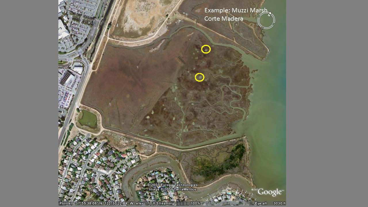 He presented a satellite picture of Muzzi Marsh, noting that it is the old-style 70s build up to maximum engineered marsh platform elevation. “It was overfilled actually, so it was the highest marsh you get,” he said. “Now, with four decades of sea level rise and lots of that dense cover of gum plant, almost all the Ridgeway Rails are occupying this later phase where they lowered the elevations to allow for geomorphic evolution [the right hand side of the picture.] … There’s a lot of good monitoring data on vegetation and channel formation and sediments, and for its day those were the operative factors.”
Dr. Baye noted that the gray dots in the picture are dead alkali bull rush, a brackish marsh plant that was riding the wave of a couple of El Niño’s. They were not very conspicuous in the marsh; they were small, but they hung on till the 2006 El Niño; after that very wet period, they expanded like an invasion. “One thing about alkali bull rush is it provides a lot of high cover. So at the same time that gum plant was fading out, dense standing biomass of very tall alkali bull rushes comes in. None of these species changes were recorded in any of the monitoring periods in the 80s or 90s. … It’s my blunt way of saying we really need to reevaluate constantly. Not from a standard template, but you have the science feed back to the monitoring protocols, making standardization not the primary goal.”
 He presented another picture, noting the presence of a remnant old dike that was breached for the restoration. He pointed out that there was a lot of bay erosion, and the levees are caving in. Another thing, in addition to the changes that were documented, here’s a remnant old dike. “The levees are on top of the marsh peat and the whole thing is starting to shift over to another kind of profile with a different level of resistance. … When this whole bayward scarf goes, you might see a step change in horizontal marsh retreat and it’s just not been on anyone’s monitoring plan because we’ve all kind of passively relied on levees.”
“That either leaves you with the options of forced engineering or armoring every marsh we build which has a lot of problems; it eliminates processes that help the marsh stay high. You armor them and prevent waves from building up sediment during storms,” he said. “Or, the alternative is that you might have to face much accelerated retreat when all these soft marshes start to get exposed to wave energy. … This is something that has not been on our monitoring radar, but I suggest as sea level rises, bay deepens and wave energy increases, we should be looking at the changes in the behavior of these marsh edges and not just assuming levees are where levees are.”
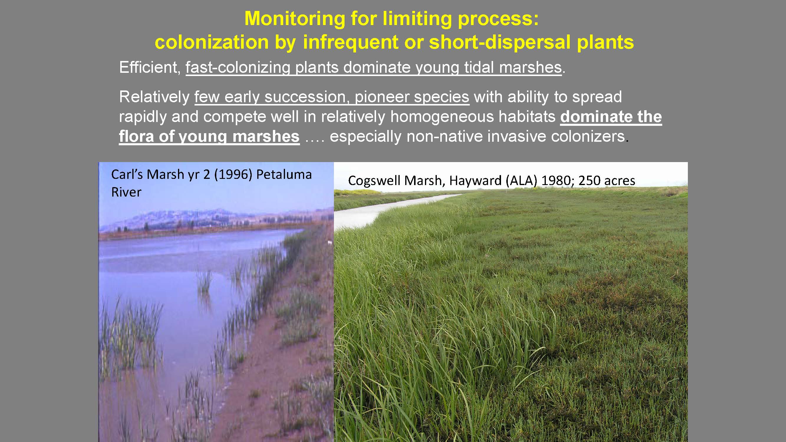 He then presented two pictures, on of Carl’s Marsh in the early stages, and one of Cogswell Marsh, one of the older restored tidal marshes in the East Bay. “One of the legacies we have in these early marshes were the focus for both design and monitoring was only on achieving elevations and cover. There was no study of species diversity or the structural diversity that comes with species diversity. So we’ve inherited our massive plains of fast colonizing species that dominate extensive areas. Even with the Baylands Goals project, we place value on species diversity, and we have no history of monitoring data that shows whether we are conserving species diversity in these restored marshes.”
He then presented a picture of Heerdt Marsh, one of the prehistoric marsh remnants that has a large population of salt marsh birds beak where it’s close to extinct. “In the 40 years that it’s had the ability to disperse into potentially suitable habitat, no one has seen it, nor is anyone monitoring for it,” he said.


Then there’s a whole suite of mostly annual species such as smooth goldfields and salt marsh owl’s clover that are almost extirpated in the bay. “There’s not evidence that they’re dispersing or in any way benefiting from tidal marsh restoration. Possibly they are in a few places, but monitoring has not been set up to detect things that were not part of the actual design. If no one is actively bringing these species in, or getting credits for them or checking off their permit checklist, the monitoring is not generating that data. That’s 40 years of data omission. Now that we do have goals for this at a regional level, we may need to make specific requirements for including these in monitoring plans; otherwise, we will continue to have largely homogenous marshes.”
 Another aspect of the kind of rigid blinders with the criteria of monitoring plans is that sometimes the unanticipated outcomes in marsh restoration projects may be more valuable than the original goals of the project, especially going into the future with sea level rise and climate change accelerating, he said.
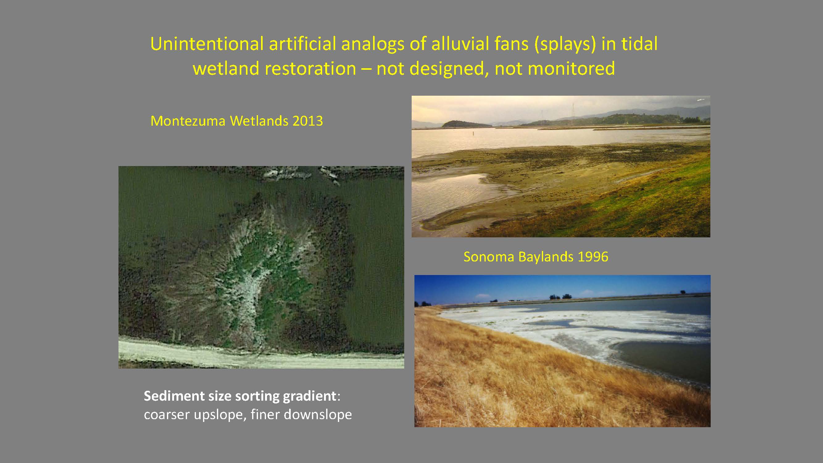
“Almost every project that uses dredge material, the goal is to spread the material out within limits of tolerance and not to exceed those tolerances, not to fall short, and use it as a platform on which natural processes build the final marsh; that’s been the standard for decades,” Dr. Baye said. “The unintended consequences of Muzzi Marsh that sort of escaped monitoring the first time, then generated the next generation of marsh design. The Sonoma Baylands is considered the second generation flagship for the new 90s restoration style … both at Sonoma Baylands and at Montezuma where you have point discharges from the dredge pipes, you develop as you might expect the coarse sediments, the silts, the coarser silts and the sands would drop out and form these deltaic splays where sediment stands. It made these high elevation splays that were not to spec. Engineers did not like them because they exceeded the tolerances of the elevation. Again, the goal was to make a marsh plain platform on which channels would stay and it ended at the levee.”
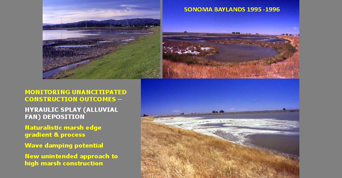 “Now we can look back at this and think okay, high marsh transition zones, super tidal transition zones, raw gently sloping areas with dense vegetation dissipating wave energy, species diversity in those transition zones – These are things we actually can make use of now. After 20 years of restoration at Sonoma Baylands and the construction period of Montezuma, we have absolutely no data on this,” Dr. Baye said. “Again, off spec, off brand, no data. But these were huge assets. They are in some ways ecological capital for the challenges of restoration in the next decade but unfortunately we have no monitoring basis to learn from how they evolved other than reconstructing their evolution from aerial photographs. But it was pretty clear that these were emulating natural processes and structures.”
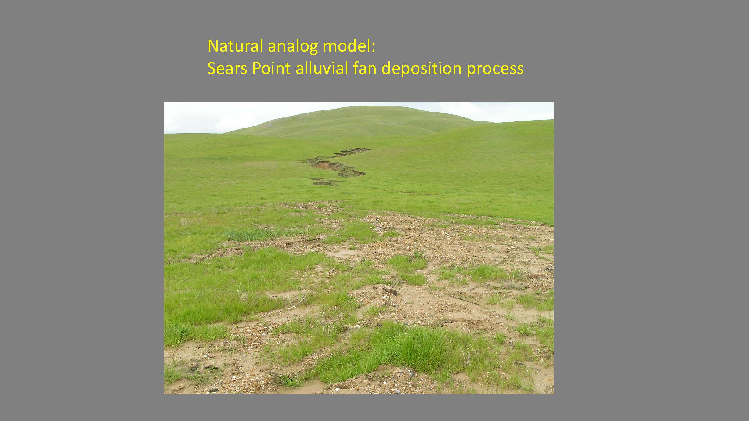 He then presented a picture of an alluvial fan that is located right behind Sonoma Baylands, and is one of the only active alluvial fans connecting right to the Baylands in the whole estuary. “It was doing an almost perfect imitation of this process, which is the 2006 El Nino. These stands would normally deposit the platforms for high margin transition zones at the back of the marsh ahead of sea level. The highest tides don’t deposit much suspended sediment but terrestrial processes have no trouble providing these gentle gradients. So we have no data on this.”
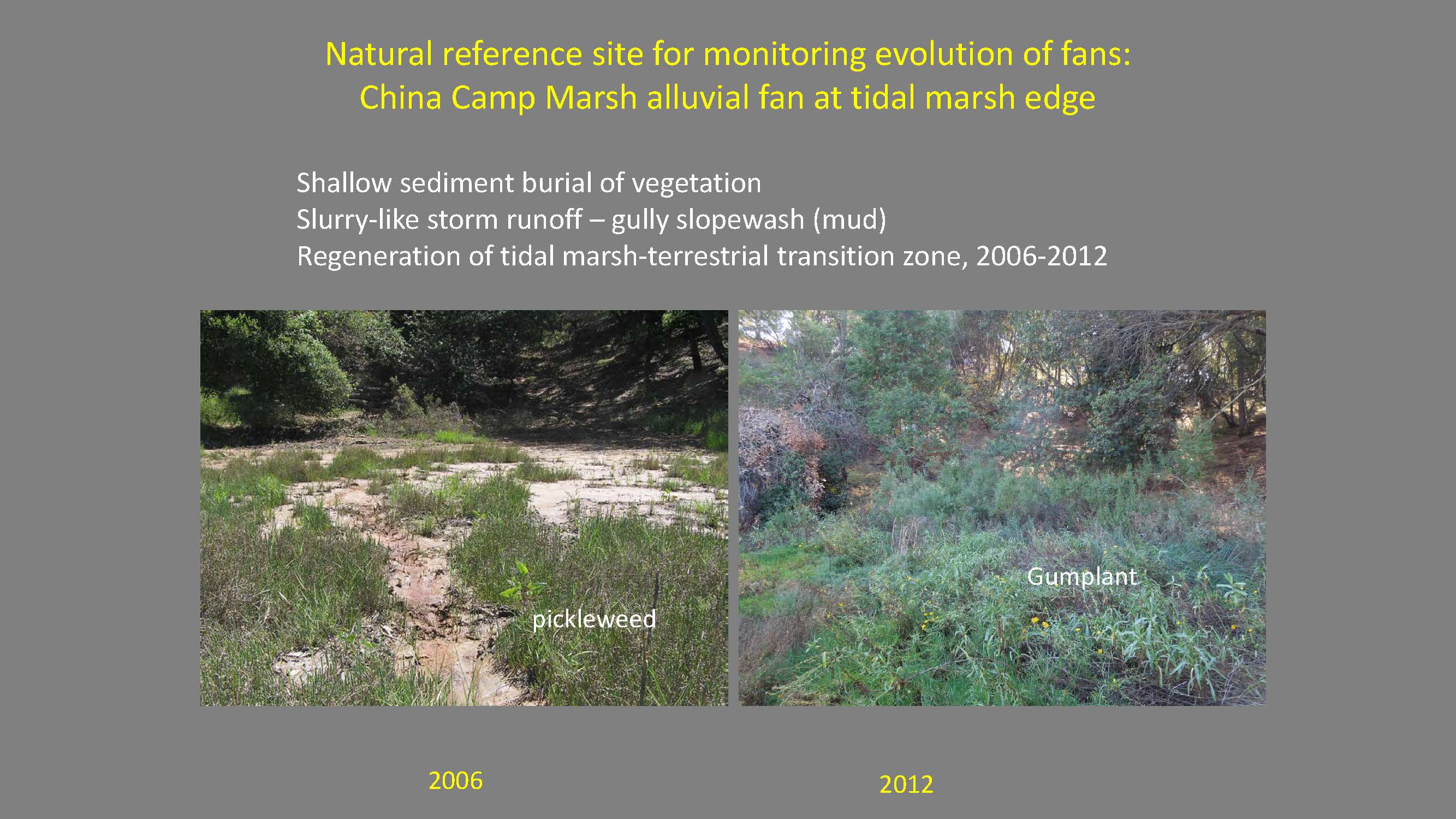 He next presented a picture of China Camp, probably one of the most studied marshes in the area, but he noted that no one was studying the terrestrial sedimentation process which we know now is really critical for making these restoration projects survive sea level rise, he said.


“Here’s the long-term evolution,” he said. “Ten years later, there are massive areas of gum plant grading down to pickle weed grading down to cord grass. At the time, all the shallow, open water for other reasons Sonoma Baylands was kind of stalled. It had sort of arrested development for a period. So most of the highest order objectives were being achieved right on these non-spec features where we have a monitoring blackout. They really were pretty spectacular. They produced the only really extensive high marsh terrestrial ecotone in the project site and the largest expansions of gum plant.”
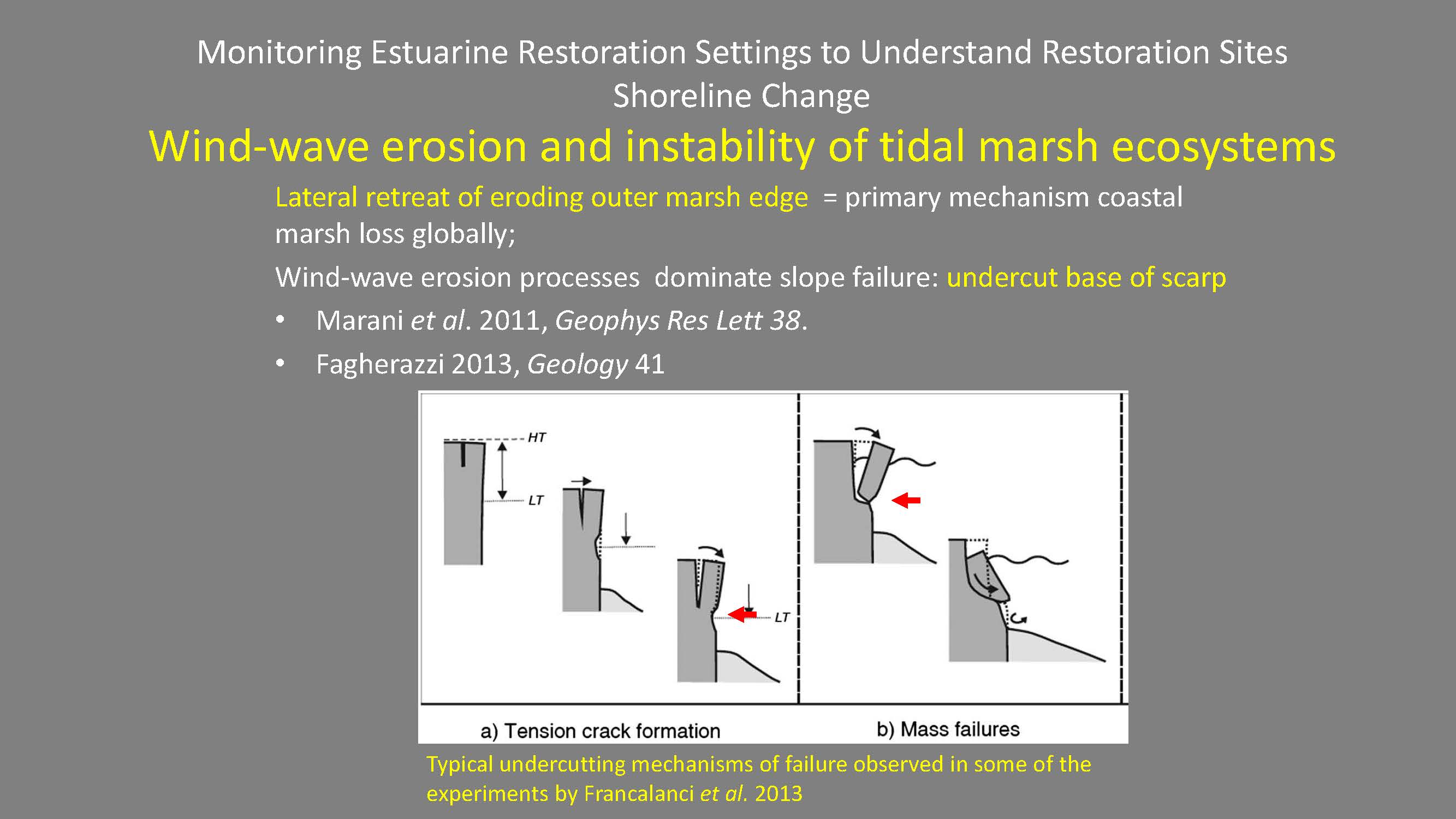 Dr. Baye then said another thing that is not being monitored is wind wave erosion and instability of tidal marsh edges. Globally there’s been a lot of recent evidence suggesting that it’s not vertical instability such as falling behind in sea level and drowning the low marsh that’s an issue, but worldwide, it’s the horizontal instability and lateral retreat of marshes that is a larger source of salt marsh loss, he said.
Back in 1979, a study estimated net erosion on different parts of the bay. “A lot of the bay is not retreating; in the North Bay, there were pockets of marsh expansion. Maybe that’s an important thing for selecting restoration sites, but this is ignored,” he said.


Recently, researchers went back and compared the historic patterns of marsh shoreline change for the period from 1855-1993. There was a lot of net change progradation and pure erosion hot spots where old marshes are cropping out into the bay making headlands. “Most of the bay looks fine and this is where most of our restoration projects were planned. No one would monitor the outside of a restoration project because you take it for granted that it’s safe.”
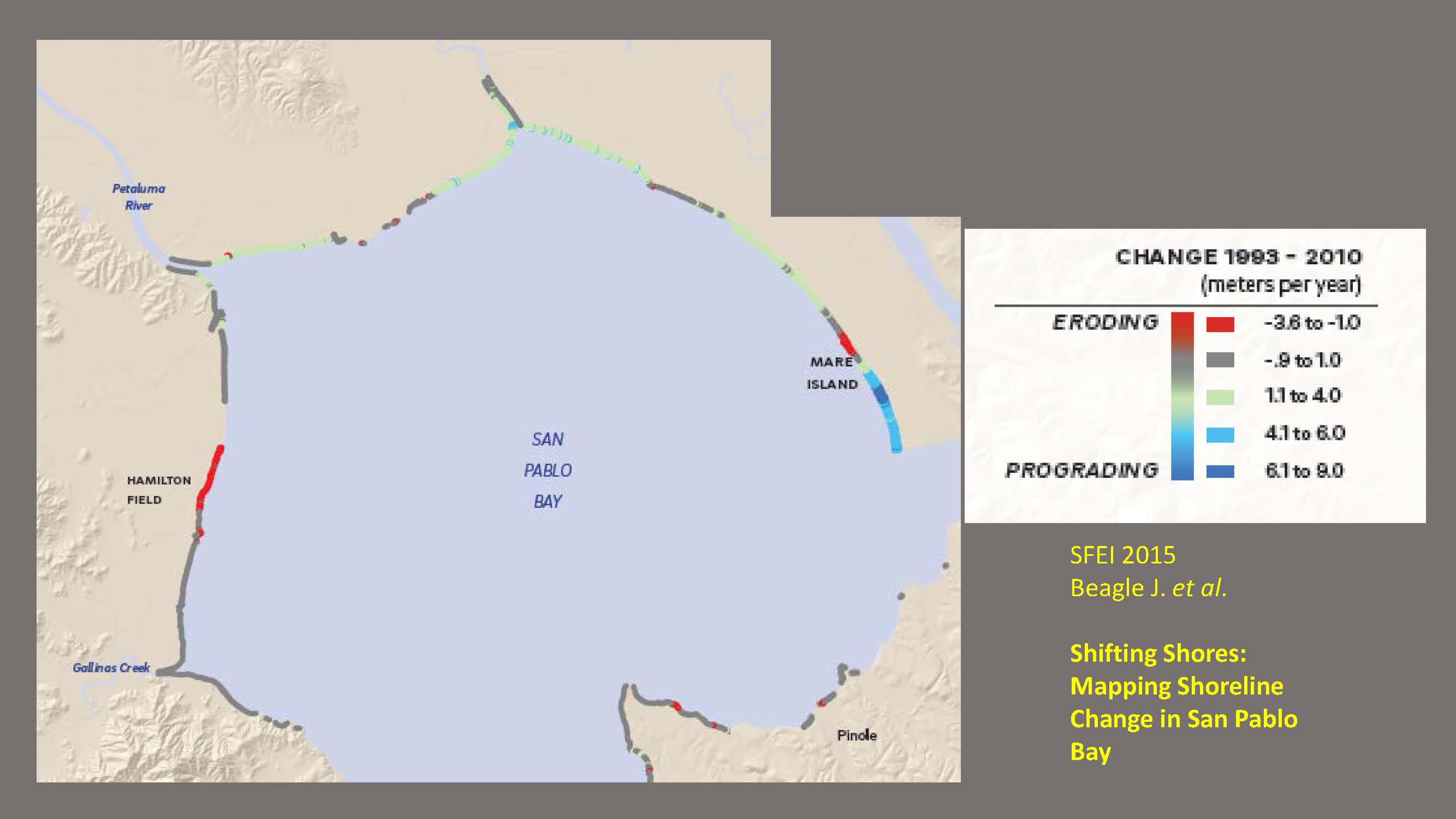 He then presented a map of the shoreline change from 1993-2010, after the Baylands Goals project began. “There is complete reversion; only the tip of Mare Island is showing strong net progradation change. There’s actually a little bit of some progradation spots but it’s slowing down. Most of the exterior marshes are undergoing now rapid retreat. The environmental setting dictates the way project sites work. Our old 70s, 80s, 90s habit of only monitoring within your site is something that may come back to bite us. Again, the worst it could result in the reactive armoring of shorelines to keep things the same when you see change or it could also be used as a guide to where we put our resources.”
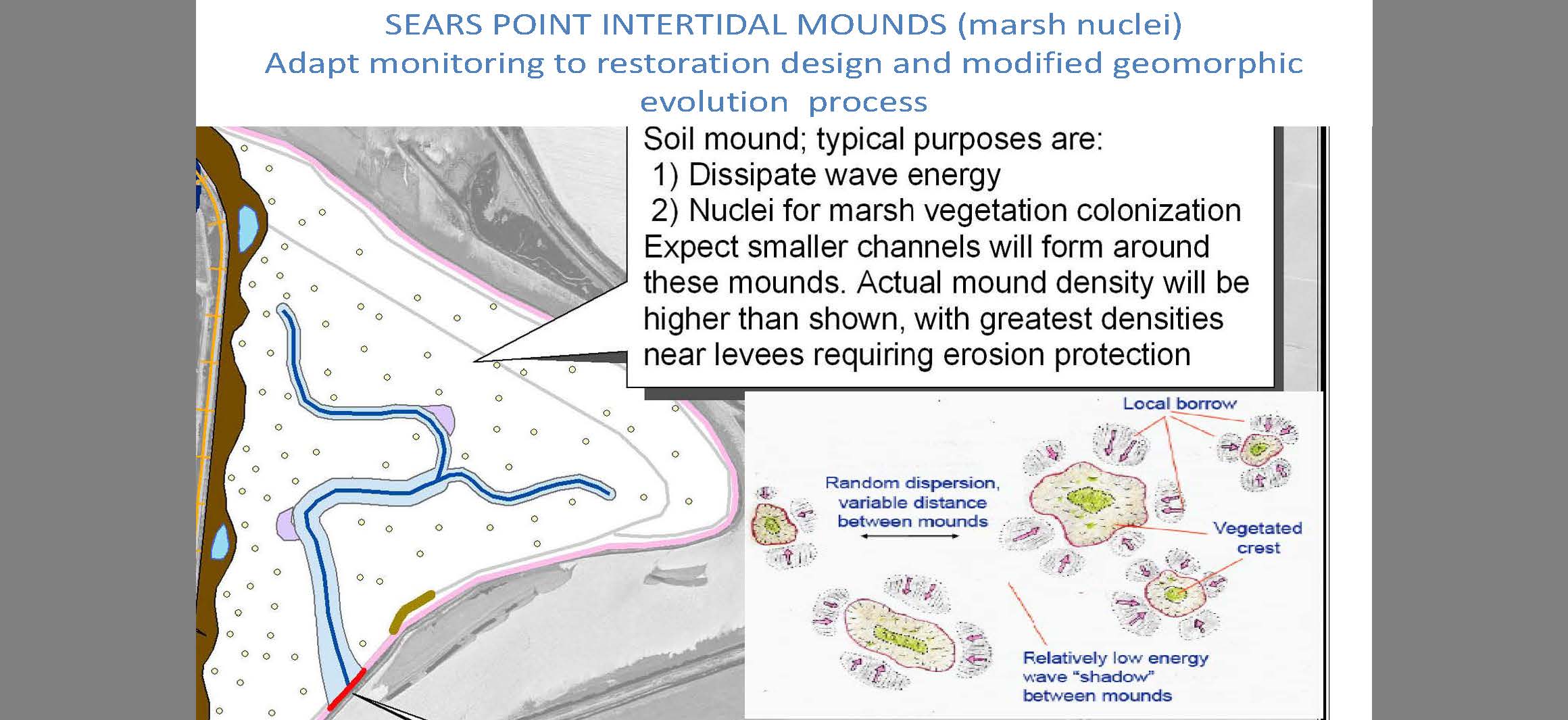 He presented a diagram of the Sears Point project near the mouth of the Petaluma River. “We have always sort of looked at monitoring vegetation change on marsh platforms as sort of a homogenous process; you just measure net cover, but not the pattern of colonization or the patterns of coalescence, or what initiates marsh or where it initiates,” he said. “In this case we’ve created new designs and tried to nucleate points where marshes are established by creating rough high spots and expecting the colonial growth patterns to spread out. That suggests we’re engineering a new pattern of colonization and suggests a new way of requiring data going from transects … to more comprehensive aerial photo analysis of marsh spread rates.”


The design itself indicates what the monitoring should be, he said. “The marsh progradation, rhyzome elongation rates and distribution of these points, are we getting colonization between these elevated mounds that are designed as celling nurseries. Is all of the marsh restoration occurring only at these mounds? If that’s the case, that suggests that this kind of design, this speckled marsh mound design at Sears Point.”
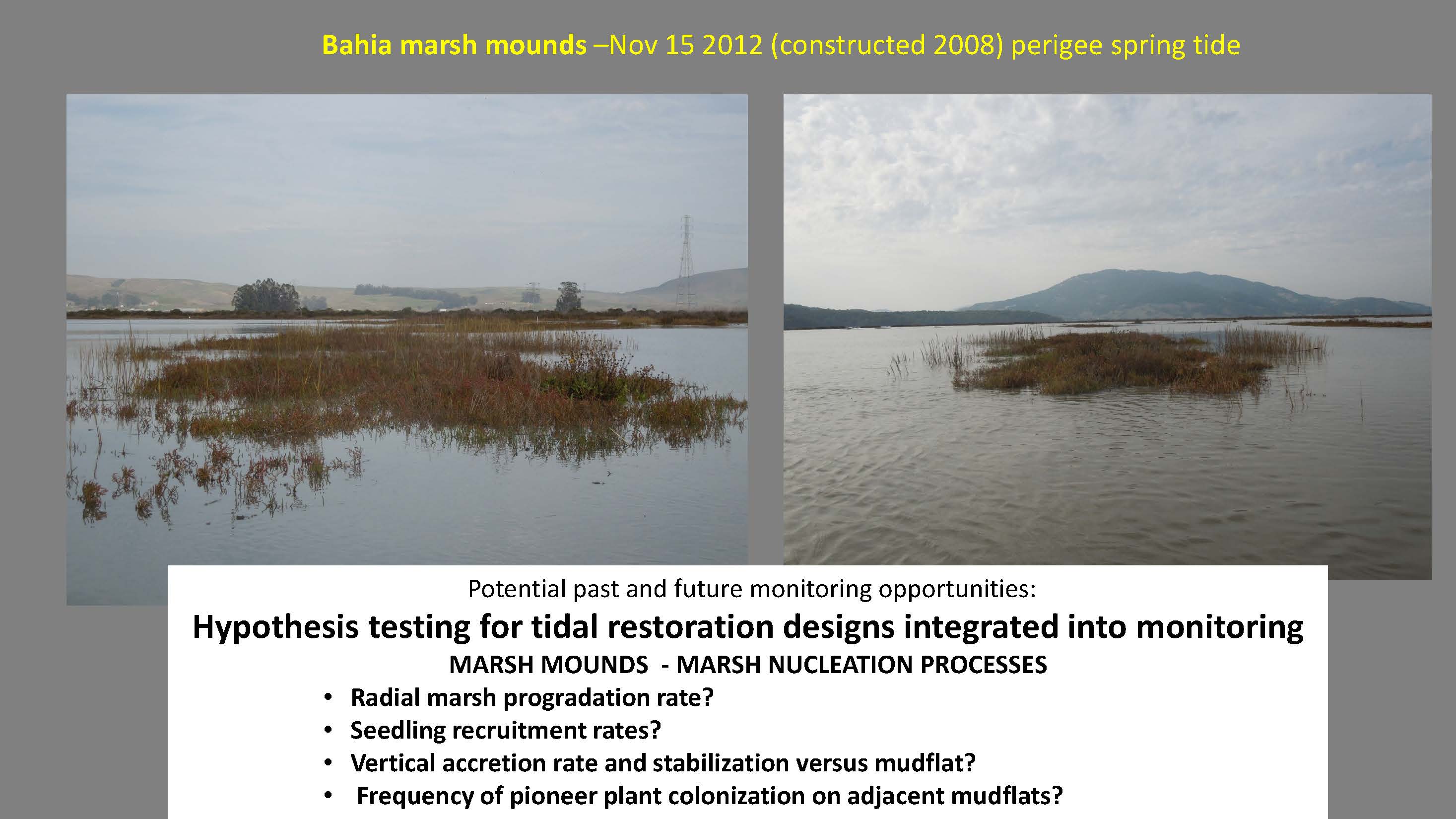 The Bahia wetlands were not actively vegetated, but it did what was predicted. “The only place in the marsh interior where there is marsh radial progradation spreading into the adjacent mudflats is along the fringes and on these marsh mounds,” he said. “This may be a way of triggering marsh evolutionary processes rather than just waiting for it to happen. So one thing you could do is develop testable hypothesis and build the monitoring around those hypotheses so you get conclusive data as opposed to sort of dealing with trend data or performance evaluation.”
 He then gave one last unexpected outcome, presenting a map of the Sonoma Baylands, which was clapper rail habitat, Ridgway rails, and salt marsh harvest mouse habitat. “We wanted to maximize marsh, minimize mudflats, and get it done as fast as possible,” he said. “There was tidal choking and for the first five years or so it became a micro tidal lagoon. It was flooded at all tidal stages. That was not the goal. There was no monitoring of anything other than mudflat and marsh because that was the model. But what happened to it, we developed a couple hundred acres of submerged aquatic habitat … The Army Corps and [others] were expecting a rapid shore bird invasion in mudflats. What they got were pintail numbers that would be the envy of any Suisun Duck Club. … We had hundreds of acres of essentially a new ecosystem, an alternate state of that tidal marsh. Zero data, no measurement. This is what the surface looked like, could not miss it.”
“Here’s the significance for Suisun,” he said. “We have a lot breached basins that are subsided. If there’s an accidental breach, their initial state would probably be probably be SAV habitat while at the same time the estuary’s background condition is clearing. We’re getting a sudden clearing of estuaries; suspended sentiments are dropping and they are not coming back.”
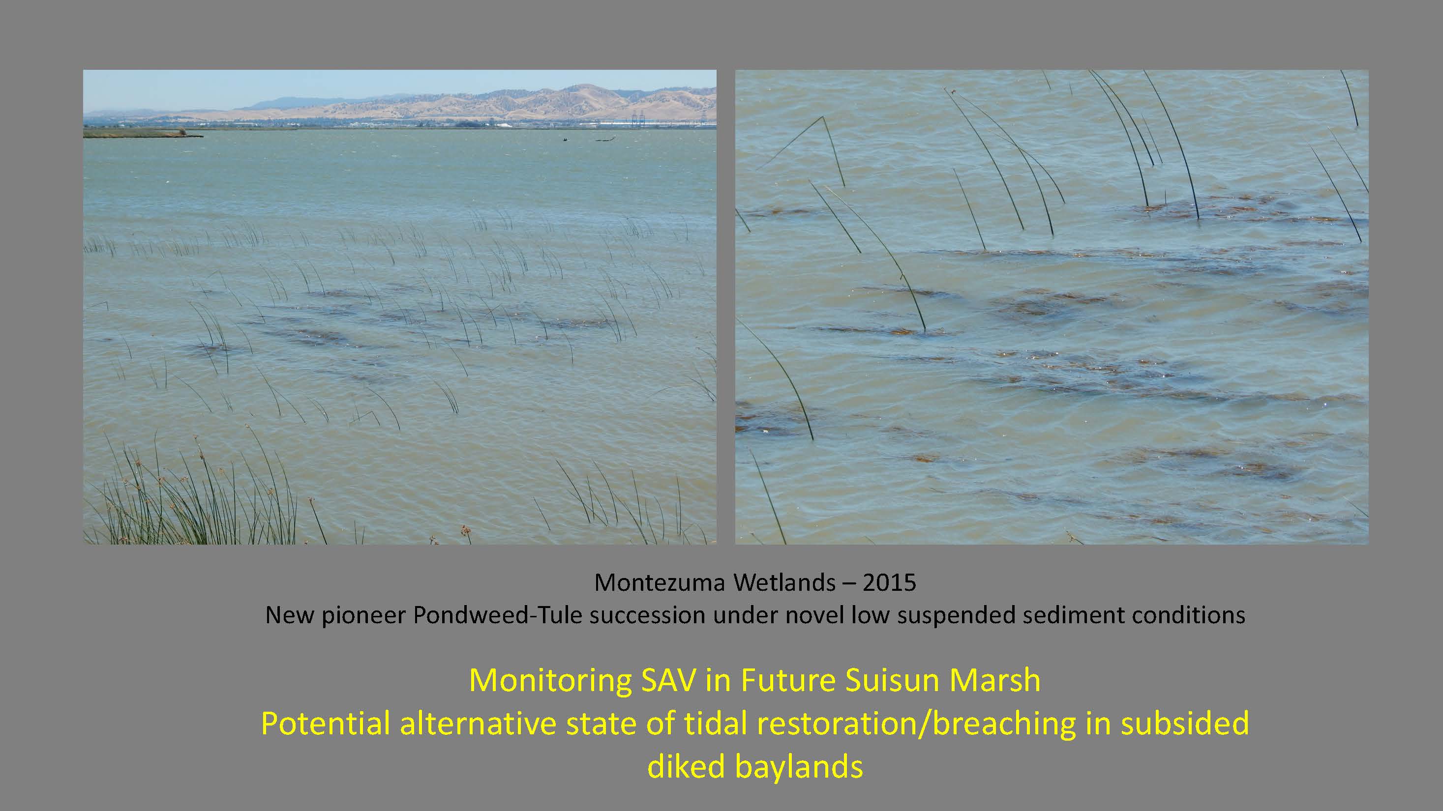 What we’re seeing now is a new kind of marsh succession, Dr. Baye said. “The tidal areas, we expect mudflats, tule succession, more tule, higher marsh. What’s happening now is tules are co-dominant with a species of stuchenia, a native one. This is probably like a giant fluvial phenotype of sego pond weed; it grows 15 feet long massive wave tolerance and it’s colonizing these low areas. This is something that if something is not restorable as the tidal marsh, it may be very valuable ecosystem function … but we have no monitoring for it.”
And being out of time, Dr. Baye’s presentation was then finished.
FOR MORE INFORMATION …
- Click here to watch the webinar.
- Click here for Dr. Baye’s full power point presentation.
- Click here for more brown bag seminars covered on Maven’s Notebook.
