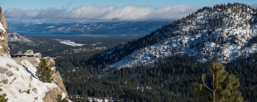
A look at Lake Tahoe, Calif. from Hwy 50 on the morning of the first snow survey for the 2015/2016 season.
From the Department of Water Resources:
The Department of Water Resources (DWR) conducted the winter’s first media-oriented manual snow survey today, and despite the higher-than-average water content for the statewide snowpack, officials said snowfall during the remainder of the winter will largely determine whether California’s drought will be entrenched for a fifth year.
DWR Director Mark Cowin said the heavy snowfall so far during Water Year 2016 “has been a reasonable start, but another three or four months of surveys will indicate whether the snowpack’s runoff will be sufficient to replenish California’s reservoirs by this summer.” Each water year begins on October 1 and ends on the following September 30.
DWR conducts five media-oriented snow surveys in the Sierra Nevada each winter – near the first of January, February, March, April and May – at the Phillips Station plot (elevation 6,800 feet) just off Highway 50 near Sierra-at-Tahoe Road 90 miles east of Sacramento.
Frank Gehrke, chief of the California Cooperative Snow Surveys Program, said more than four years of drought have left a water deficit around the state that may be difficult to overcome in just one winter season.
“Clearly, this is much better that it was last year at this time, but we haven’t had the full effect of the El Niño yet,” Gehrke said. “If we believe the forecasts, then El Niño is supposed to kick in as we move through the rest of the winter. That will be critical when it comes to looking at reservoir storage.”
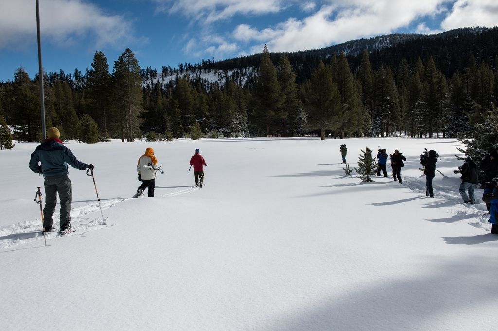
A group of news media follow the Department of Water Resources along with the United States Geological Survey for the first media snow survey for the 2015/2016 season.
The state’s largest six reservoirs currently hold between 22 percent (New Melones) and 53 percent (Don Pedro) of their historical averages in late December. Storage in Lake Shasta, California’s largest surface reservoir, is 51 percent of its December 30 average.
Today’s manual survey found a snow depth of 54.7 inches – 16 inches more than the average depth measured there since 1965 – and 16.3 inches of water content, 136 percent of the January 1 average for that site.
More telling than a survey at a single location, however, are DWR’s electronic readings today from 99 stations scattered throughout the Sierra Nevada. Measurements indicate the water content of the northern Sierra snowpack is 11 inches, 108 percent of the multi-decade average for the date. The central and southern Sierra readings were 12.1 inches (116 percent of average) and 7 inches (86 percent) respectively. Statewide, the snowpack held 10.2 inches of water equivalent, or 105 percent of the December 30 average.
One year ago, the north, central, south and statewide readings respectively were 5.8 inches (57 percent of average), 4.7 inches (45 percent), 4.0 inches (48 percent) and 4.8 inches (50 percent).
In normal years, the snowpack supplies about 30 percent of California’s water needs as it melts in the spring and early summer. The greater the snowpack water content, the greater the likelihood California’s reservoirs will receive ample runoff as the snowpack melts to meet the state’s water demand in the summer and fall.
Results of today’s manual readings by DWR near Echo Summit are as follows:
Location
Elevation
Snow Depth
Water Content
% of Long-Term Average
Alpha
7,600 feet
Unavailable
Phillips Station
6,800 feet
54.7 inches
16.3 inches
136
Lyons Creek
6,700 feet
58 inches
14 inches
120
Tamarack Flat
6,500 feet
Unavailable
Despite snowpack readings that are higher than last year, the major water reservoirs are storing far less water this year than their late-December historical averages. Lake Oroville in Butte County, the State Water Project’s (SWP) principal reservoir, now holds 1 million acre feet (MAF), 29 percent of its 3.5 million acre-foot capacity and 47 percent of its historical average on December 30. One year ago today, Oroville’s numbers were 1.3 MAF, which was 62 percent of its December 30 average.
Lake Shasta north of Redding and the federal Central Valley Project’s (CVP) largest reservoir now holds 1.4 MAF, 31 percent of its 4.55 million acre-foot capacity and 51 percent of its historical average. One year ago today, Shasta held 1.9 MAF, which was 41 percent of its total capacity and 66 percent of the December 30 average.
San Luis Reservoir, a critical south-of-Delta pool for both the SWP and CVP, reflects the same trend of lower reservoir storage this year. San Luis currently holds 20 percent of its 2 million AF capacity, 30 percent of normal for the date.
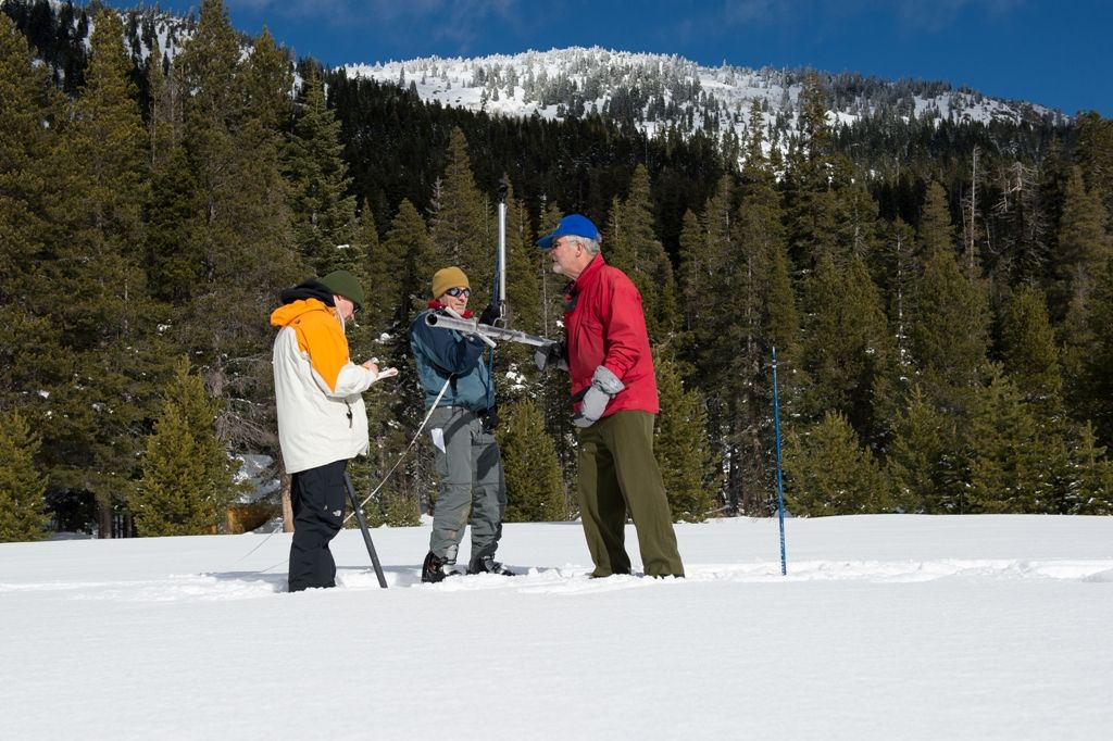
Frank Gehrke, Chief Snow Surveyor for the Department of Water Resources, along with John King, center, with DWR Snow Survey and Frank Anderson with the United States Geological Survey, left, at the first media snow survey for the 2015/2016 season.
Governor Edmund G. Brown Jr. declared a drought State of Emergency on January 17, 2014 and directed state officials to take all necessary actions to prepare for water shortages. On April 1, 2015, when the statewide snowpack’s water content was historically low at 5 percent of that date’s average, Governor Brown mandated a 25-percent reduction in water use across the state. Californians have largely complied with the mandate; from June through October, water consumption was down 27.1 percent statewide compared to the same period in 2013, according to the State Water Resources Control Board.
Conservation – the wise, sparing use of water – remains California’s most reliable drought management tool. Each individual act of conservation, such as letting the lawn go brown or replacing a washer in a faucet to stop a leak, makes a difference over time.
Californians can learn easy ways to save water every day by visiting SaveOurWater.com. California’s efforts to deal with the effects of the drought can be found at drought.ca.gov.
This slideshow requires JavaScript.
Electronic snowpack readings are available on the Internet at: http://cdec.water.ca.gov/cdecapp/snowapp/sweq.action For earlier readings, click the calendar icon below the map, select a date, then Refresh Data.
Water Year 2016 precipitation can be found at the following link; look in the right-hand column for the Northern Sierra 8-station index for updated rainfall readings in the critical northern portion of the state, as well as the San Joaquin 5-station and Tulare Basin 6-station links: http://cdec.water.ca.gov/snow_rain.html
For a broader snapshot of current and historical weather conditions, see DWR’s “Water Conditions” and “Drought” pages:
Visit SaveOurWater.com to find out how everyone can do their part, and visit http://drought.ca.govto learn more about how California is dealing with the effects of the drought. The Department of Water Resources operates and maintains the State Water Project, provides dam safety and flood control and inspection services, assists local water districts in water management and water conservation planning, and plans for future statewide water needs.
Sign up for daily email service and you’ll always be one of the first to know!
Sign up for daily emails and get all the Notebook’s aggregated and original water news content delivered to your email box by 9AM. Breaking news alerts like this one, too. Sign me up!
Maven’s Notebook constantly watching over the world of California water


The Department of Water Resources (DWR) conducted the winter’s first media-oriented manual snow survey today, and despite the higher-than-average water content for the statewide snowpack, officials said snowfall during the remainder of the winter will largely determine whether California’s drought will be entrenched for a fifth year.
 Maven’s Notebook