

 DWR update provides an overview of GSA formation to date and a preview of new tools to aid GSAs in developing their groundwater sustainability plans

At the April meeting of the California Water Commission, Trevor Joseph and Steven Springhorn with the Department of Water Resources Sustainable Groundwater Management program gave a high-level overview of how groundwater sustainability agency formation is going so far, along with a preview of new data tools that the Department is working on to provide information to the groundwater sustainability agencies as they are developing their groundwater sustainability plans.
Trevor Joseph began with an update on the status of the Department’s important projects and activities related to implementation of the Sustainable Groundwater Management Act.
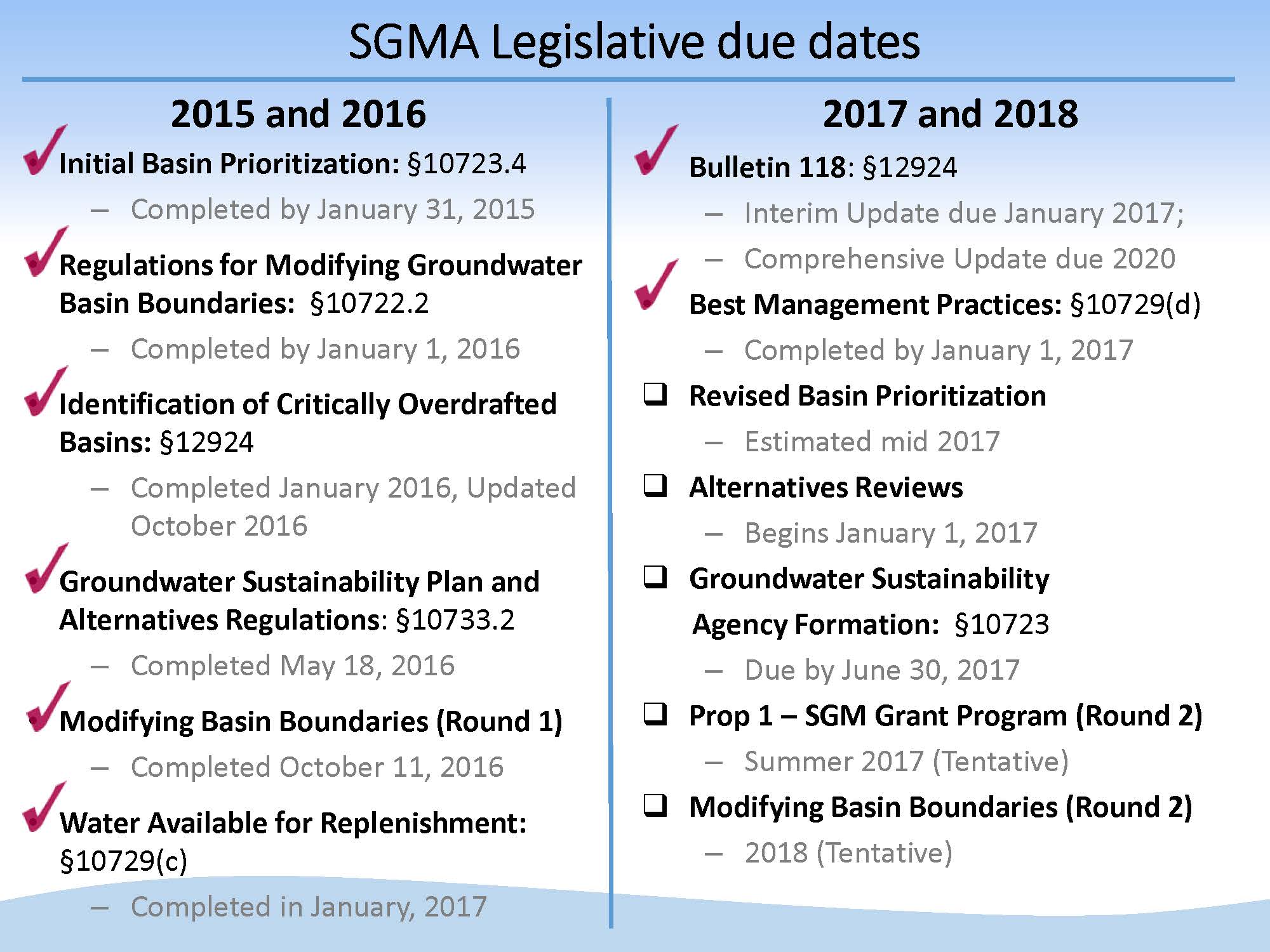 Since the Sustainable Groundwater Management Act passed in September 2014, many activities related to implementation have been completed. Mr. Joseph noted that there has already been one round of basin boundary modifications, which was completed in 2016. Another round is anticipated in early 2018; the Department is required to provide a summary and overview of those draft basin boundary change recommendations and receive feedback from the public and the Commission before the modifications are approved.
GROUNDWATER SUSTAINABILITY AGENCY FORMATION
The Sustainable Groundwater Management Act requires local agencies who want to be the Groundwater Sustainability Agency (GSA) for their groundwater basin submit notification to the Department in order to potentially avoid State Water Resources Control Board intervention; it is also a signal to the state that these local agencies intend to prepare groundwater sustainability plans (GSPs).
The Sustainable Groundwater Management Act applies to high- and medium- priority groundwater basins throughout the state; 127 out of the state’s 517 groundwater basins are considered high and medium priority. “That means that local agencies, if they choose to, need to cover these high and medium priority basins, and ultimately prepare Groundwater Sustainability Plans, an alternative, or be covered by an adjudication to avoid intervention by the State Water Resources Control Board.”
Mr. Joseph pointed out that although 127 out of 517 groundwater basins sounds like a low number, it in fact actually represents the vast majority of the groundwater pumping throughout the state. “96% of groundwater pumping overlying groundwater basins throughout the state actually occurs in high and medium priority basins,” he said. “In addition to that, the population of these high and medium priority basins in terms of the total population of all the basins is 88%, so these high and medium priority basins are just that for a reason. There is a high percent of statewide population and groundwater use in these applicable basins for SGMA.”
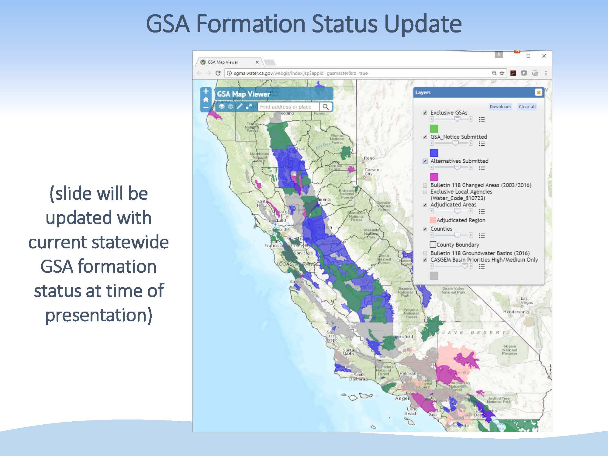 Mr. Joseph then presented a map showing the 127 high and medium priority basins, noting that GSA formation is a dynamic and ongoing activity, and it’s hard to report specific numbers because they are constantly changing. The basins shown in blue indicate those for which the Department has received GSA formation notifications. Those shown in purple are where two or more different GSAs or local agencies have submitted notifications for the same area; overlaps do need to be resolved by July 1, 2017 in order for that local agency or group of agencies to continue to be the GSA for the purposes of pulling together groundwater sustainability plans.
Mr. Joseph noted that there’s a lot of blue on the map, meaning a lot of local agencies have come together especially in the last few months and have worked out the details to submit GSA formation notifications to the Department. “This is a really good sign,” he said. “The gray area is areas outside of GSA formation notifications, and that doesn’t mean by the deadline of July 1st, those gray areas won’t be filled with other local agency submissions. In fact, we’re out talking with local agencies and counties and we anticipate a very large percent of the high and medium priority basins will be covered by the legislative deadline, so again we think this is a really good sign of success. I will caveat that with we don’t know, there’s still things that could blow up at the 11th hour and some overlap could not get resolved, so that’s the challenge of explaining how successful we are to date, because it’s still an evolving process.”
Besides forming a groundwater sustainability agency, local agencies also have the opportunity to submit an alternative to the Department; those basins are shown in the darker pink.
Adjudicated areas, shown in light pink, are exempt from most aspects of SGMA; they have a reporting requirement and had to submit some initial information to the Department. Those, in some cases, cover portions or all of high and medium priority basins. So again, that’s more coverage, kind of like the alternatives.
“When you put this all together, there’s starting to be some gray which is potentially unmanaged areas, and there’s a low percent of the high and medium basins that to date is not covered by either an alternative, an adjudication, or a GSA submittal,” Mr. Joseph said. “Again, the point is that we’re starting to see a lot of success from our perspective that the local agencies are really taking this to heart and coming to the state with these formation notifications, the next step being then to develop GSPs. There are a couple more months before the July 1st deadline, but it appears really positive.”
SUBMISSION OF ALTERNATIVES
Alternatives were an opportunity for a local agency to submit some information to the Department in lieu of preparing a groundwater sustainability plan. There were three types of alternatives: an existing groundwater management plan or a law authorizing groundwater management, an adjudication, or an analysis that a basin or subbasin has been operated to a sustainable yield for a period of ten years. The basins submitting an alternative groundwater management plan or analysis of operation to a sustainable yield were required to submit those by January 1, 2017; those basins are shown in blue.


SGMA and the GSP regulations allow for the public to comment on the alternatives. The public comment period was 60 days from January 1st, and was extended at the public’s request to April 1st. “By April 1st, we had received 150 public comments on these alternatives,” Mr. Joseph said. “The bar chart indicates the amount of comments received for each of the alternatives. A lot of these comments are pretty detailed public comment letters. I should mention the alternatives are also very detailed documents, highly scientific. Averaging at least 300 to 500 pages. A lot of information to process as well as the public comments.”
The nature of the public comments range from support to disapproval of specific alternatives; many of the public comments focused on surface-groundwater interaction. The alternatives and the public comments received are available on the website.
 There were a number of questions about how the Department will be evaluating the alternatives; Mr. Joseph said it’s no different than the evaluation process for the Groundwater Sustainability Plans.
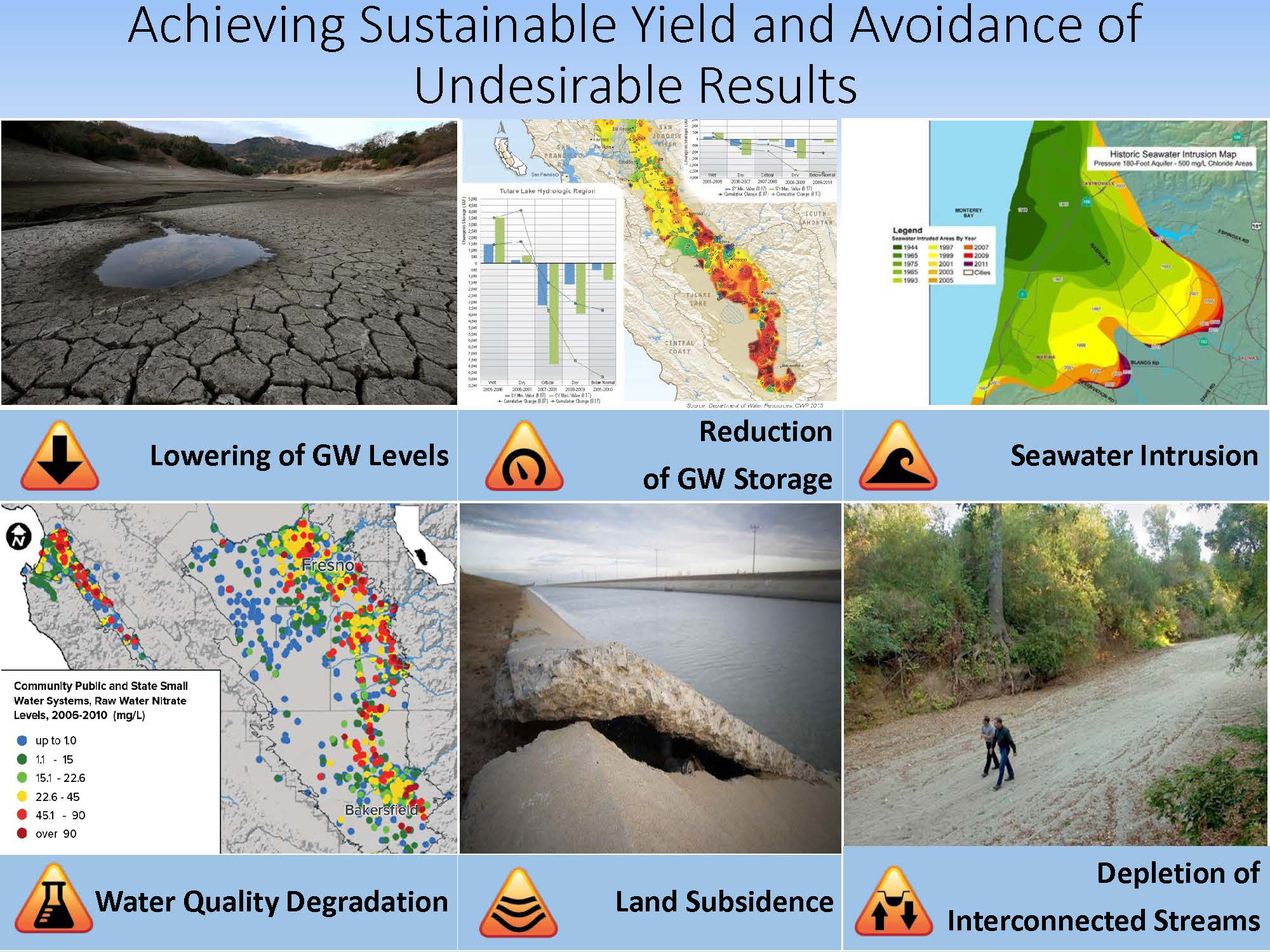
“At the highest level, an alternative is no different than a groundwater sustainability plan, meaning they have to achieve a sustainability goal as it is defined in the Sustainable Groundwater Management Act, which can be boiled down (but not completely) to the avoidance of these undesirable results,” he said. “Remember they are undesirable only when they are at significant and unreasonable levels, which is a key term. The undesirable results include lowering of groundwater levels, reduction of storage, sea water intrusion, water quality degradation, land subsidence, and depletions of interconnected surface water and groundwater.”
Mr. Joseph said that he’s often asked about the timeline for the Department to evaluate the alternatives and make a determination. “This is a new process for us. It’s a new regulation, this is the first implementation of these regulations,” he said. “We didn’t know how many we were going to receive and how many comments. In the statute we have two years to review groundwater sustainability plans. We don’t think it’s going to take quite that long for alternatives. But it is taking some time. We’re going through it methodically, we anticipate very late this year or early next year, we hope to have some information out on the status of these alternatives.”
TECHNICAL ASSISTANCE
Steven Springhorn, Senior Engineering Geologist with the Department’s Sustainable Groundwater Management Program, then updated the Commission on the work that the Department has been doing to provide technical assistance to the newly forming GSAs and their efforts to develop groundwater sustainability plans.
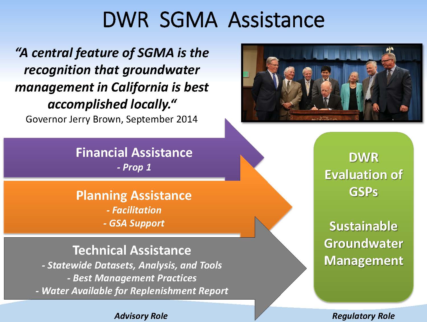 “Groundwater is best managed locally, and that has been a guiding principle for us in the development of this program,” said Mr. Springhorn. “But we are also hearing and fully expect that locals also need help and assistance through this, so the assistance is what we’re developing now.”
Mr. Springhorn’s presentation was focused more on statewide tools, analysis, and data sets, but there are other additional areas that the Department is working on. About $1.6 million has been spent on providing facilitation support to around 40 basins across the state; they plan to continue supporting and engaging with GSAs throughout SGMA implementation. Another key piece is financial assistance, as in the early years of SGMA implementation, GSAs will need funding to get things going while their funding streams are developing.
“This is our advisory role or our engagement role with SGMA and all for the goal of putting the tools and the information into the hands of the GSAs so they can successfully complete a GSP by the deadline and we can achieve our statewide goal of Sustainable Groundwater Management. And that’s where we have our regulatory role, which is relative new for us at the Department, and we have to be evaluating these GSPs.”
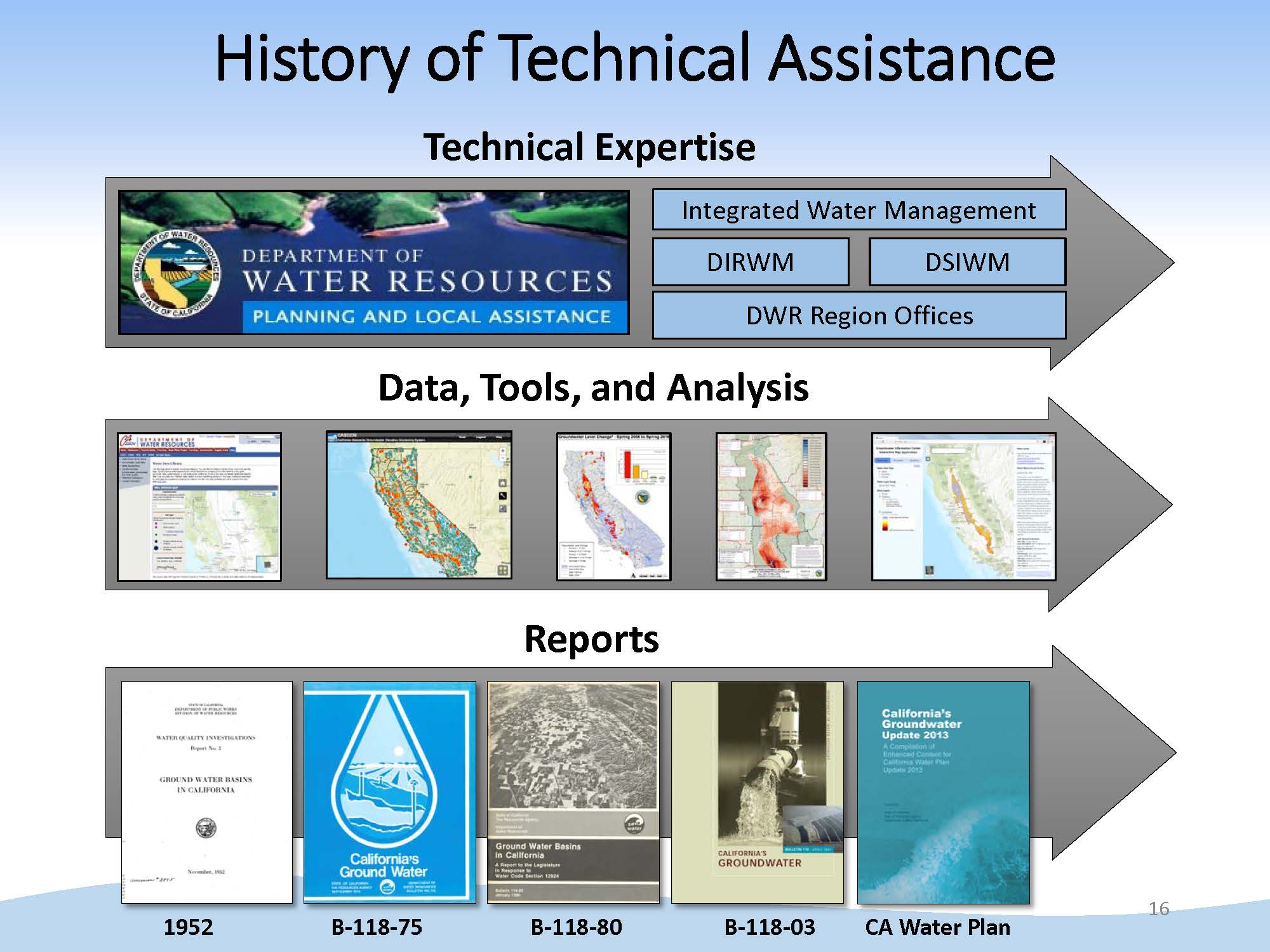 Mr. Springhorn noted that for many decades, the Department has provided technical assistance to local agencies throughout the state, and so their organizational structure is well suited for this. In addition to the staff in Sacramento, there are regional offices throughout the state that have geologists and engineers that are very well versed in the conditions and the variability within the basins in their area. The Department has also established many partnerships with the local agencies throughout the years in other efforts.
“We’ve been providing data, tools, and analysis, the CASGEM program, which is a key piece for groundwater level information; there are different maps and different reports that we’ve done throughout the years,” he said. “There is existing information out there now for GSAs to use if they are on a fast track trying to develop their GSP now … so what we want to try to do is take all the existing information that’s out there and try and focus that on the requirements and the needs of SGMA.”
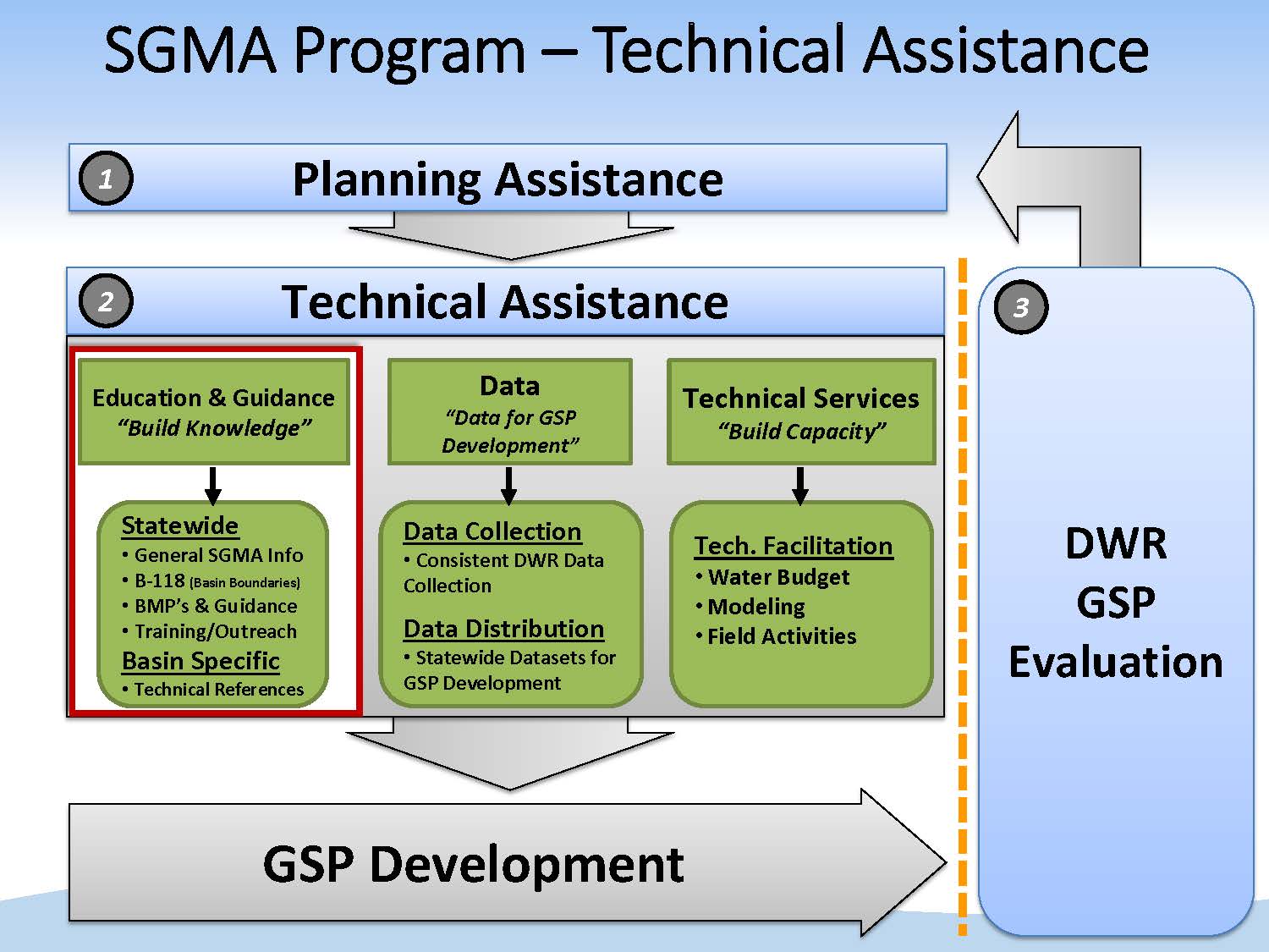 He then presented the overall framework for the technical assistance program. It starts with that planning assistance; once those GSAs are formed and have a governance structure, they will quickly turn to developing their GSP.
Technical assistance is organized into three categories:
- Education and guidance: Building the knowledge or common understanding of what the SGMA regulations are and the requirements are. This includes documents, such as the Bests Management Practices.
- Data collection and distribution: Collecting data and making informed decisions.
- Technical services: Tools and analysis needed to take the information and turn them into components of the plan, such as the water budget.
The last step, the arrow showing the cycle repeating, is important because SGMA is a long-term planning process, he said. “It’s a 20 year planning process with annual report requirements and 5 year updates of GSPs, so this is a type of assistance we plan to do into the future.”
EDUCATION AND GUIDANCE
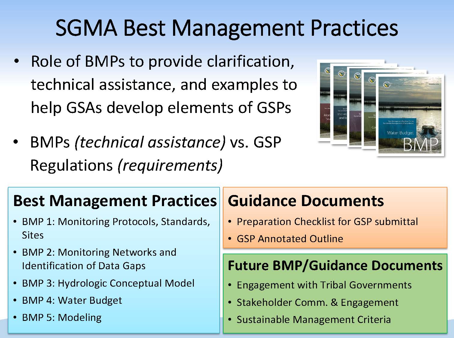 Best Management Practices are now available to provide technical assistance and point to resources for GSAs to help them comply with the regulation requirements.
“The first set of BMPs focused on monitoring, modeling, water budget, and other key pieces of groundwater sustainability plans,” he said. “There are a few additional BMP or guidance documents that we’re working on; one focusing on engagement with tribal governments, and a document on stakeholder communication and engagement. Also, the Department is working on a document on sustainable management criteria and how to set those key parameters in the plans that define sustainability and how sustainability is going to be tracked through time.”
The guidance documents on engagement with tribal governments and stakeholder communications are anticipated to be released in the near future.
DATA
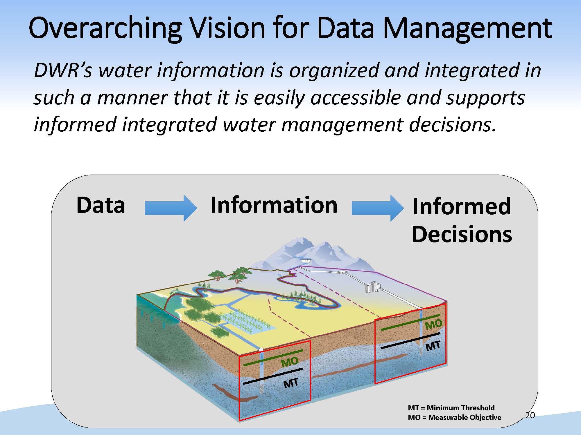 The Department has been doing some strategic thinking on how to move data management forward with these big programs coming online. “To boil it down, it is making data easily accessible, and that sounds really simple, but it’s a challenge,” Mr. Springhorn said. “Essentially, we’re trying to make the data available and give that to the GSAs so they can turn it into information and into informed decisions. SGMA puts an emphasis or premium on having informed decisions over this long planning horizon.”
Mr. Springhorn noted that there are a lot of requirements to compile data in SGMA and the GSPs, but that data is distributed in a number of areas and different websites within our agency and other state and federal agencies. “For example, at the Department we have a number of programs where relevant data resides as well as our sister agency, the State Board, and the variety of datasets that they have on water quality and other programs, and then our other state and federal partners, so there’s a lot of information out there. It’s a matter of trying to make it easily accessible.”
To that end, the Department is working on developing a clearinghouse of information. Currently, the Department’s Groundwater Information Center website is focused on mostly groundwater levels now, but they are working to enhance the available information. The platform does allow for users to download data.


Another key component of SGMA is the performance metrics of the sustainability indicators, so the Department is working to align the platform to the requirements of SGMA. Groundwater levels and change in storage is already available on the website. Later this year, the Department plans to release an online tool that allows people to download well completion reports for their basin. “This is a specific GSP requirement, and so the idea is a GSA could take this and put it right into their plan,” Mr. Springhorn said.
For water quality, the Department has been discussing with the State Water Resources Control Board, which has an existing online system for water quality data, on how to best coordinate to get that information into the hands of the GSAs.
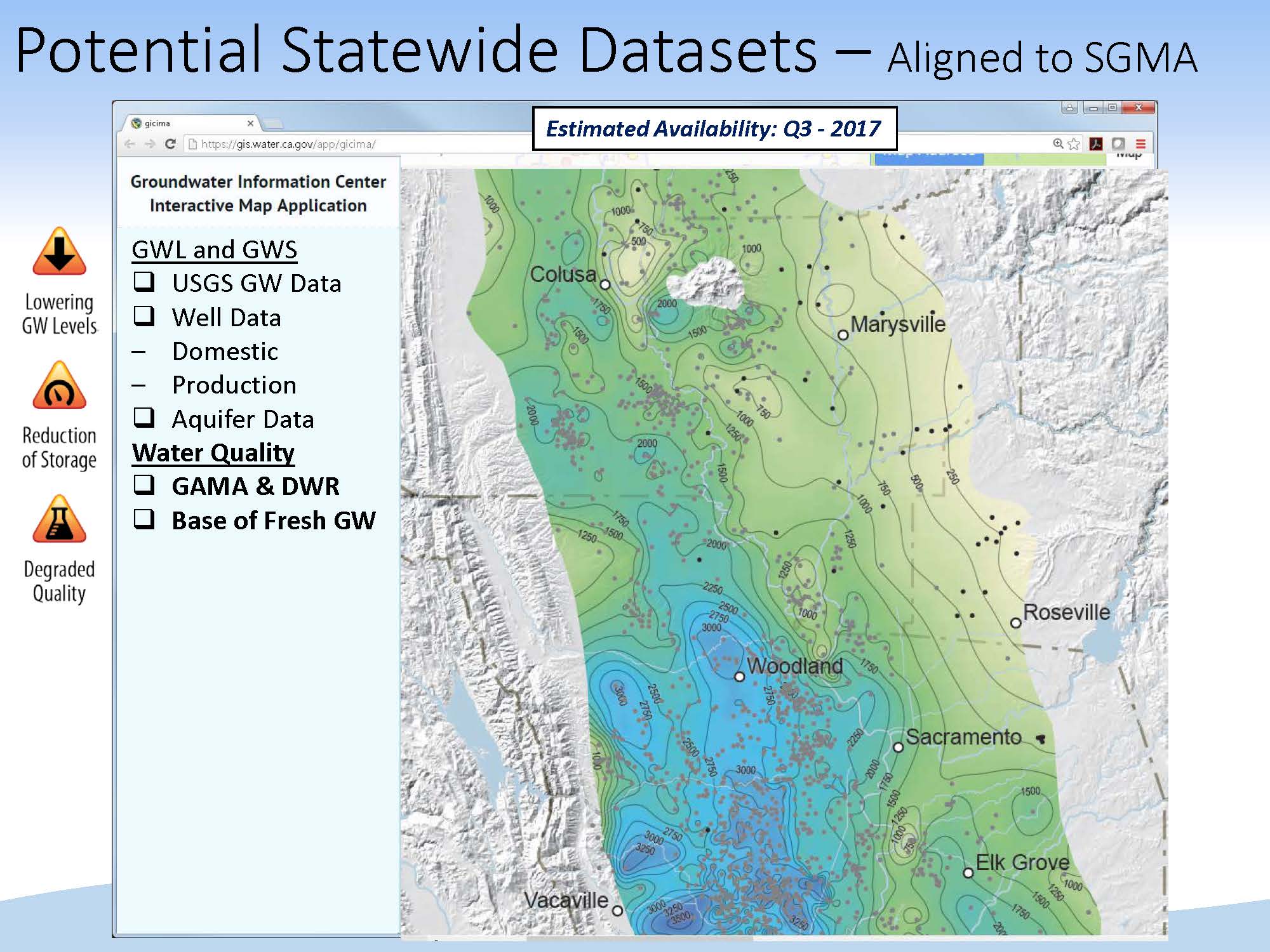 The Department is also developing a base of freshwater map for the entire Central Valley; this is expected to be available third quarter 2017. “The online map of the base of fresh groundwater will be an important piece of a GSA defining their basin and the aquifer system within their basin,” Mr. Springhorn said.
In terms of subsidence, there are two ways to monitor it: on the ground monitoring stations such as extensometers and continuous GPS sites, or by using remote sense data, such as InSAR or satellite based imagery that shows the change in land surface over time. The Department has partnered with the USGS and NASA to make the data available; it gives GSAs an idea of where and what the current or historical rates of subsidence have been in certain basins throughout the state.
There is another effort currently getting underway to resurvey hundreds of GPS monuments in the Sacramento Valley; it is a collaborative effort with counties and surveyors; this information will be a key input for some of these GSAs in the area to use in their GSPs.
They have also been coordinating with the Department of Fish and Wildlife and the Nature Conservancy on a map that displays potential groundwater ecosystems. It is another requirement in the GSP to have a map of groundwater-dependent ecosystems in their basin, so the map could be used to fulfill that GSP requirement.


Lastly, the water budget is an important part of the groundwater sustainability plan, and the Department is working on a number of datasets related to the water budget. One of those efforts is to acquire statewide land use information. “This is a highly anticipated dataset that will have statewide land use,” said Mr. Springhorn. “It’s very impressive; a field-level land use for the whole state at the same time. We plan to release that in the coming months, and we’ll roll that out publicly and have an interactive ap where people can download that information.”
TECHNICAL SERVICES
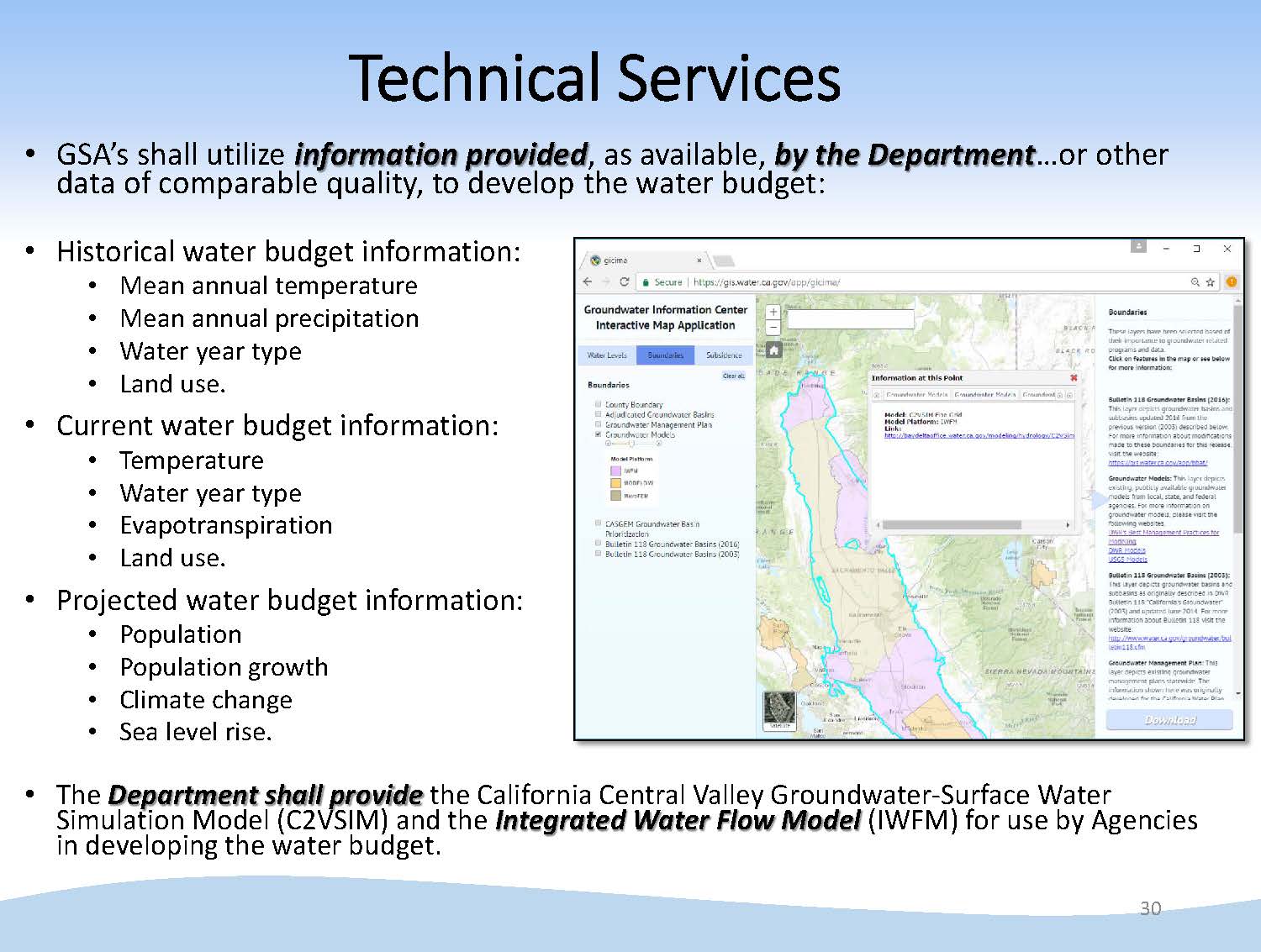 The third component is technical services. “There are a number of data requirements in the water budget, and we plan to provide the tools necessary to complete those requirements, such as models throughout the state,” Mr. Springhorn said. “We’ve partnered with the USGS to provide the model footprints for the publicly available models. You can click and get information on what the details of that model are and how you might use them for SGMA implementation.”
NEXT STEPS
“For the next steps, we want to continue to develop the scope, capacity, and maintain or build partnerships with our state and federal partners,” Mr. Springhorn said. “We want to engage. We’re going to be kicking off a series of meetings, engaging practitioners and stakeholders to see what their needs are in the basin throughout the state, which will help us prioritize the datasets and tools we move to the front of the order and get out first. Then we want to build and expand this capability and this program overtime.”
“Finally an important piece is maintenance,” he continued. “We want to make sure we continue to maintain the data collection and the distribution of that data because a monitoring well or a stream gauge is only as good as it’s period of record, and so what we’ve talked about today with the emphasis on information and data driven decision under SGMA, we need to have those long-term periods of record for people to rely on moving forward.”
IN CONCLUSION
Trevor Joseph then concluded the presentation by noting that now that the legislative requirements are mostly behind them, the Department is really focused on providing the financial planning and technical assistance moving forward so that local agencies can complete their plans on time, either by 2020 or 2022. “It seems like a long time out, but 2020 is now just around the corner, and 2022 not too far behind it, so a lot of work to get done between now and then. Obviously the local agencies have the tough life right now, but we’re doing what we can to help them meet those requirements.”
DISCUSSION
Commissioner Orth asked Mr. Springhorn to elaborate on the map of the base of fresh groundwater.
“It’s for the Central Valley,” he said. “What we did is we looked at a number of water resource wells and our monitoring wells, where we had either geophysical logs or water quality information for the aquifer system; we picked a value of Total Dissolved Solids of 1000 TDS to differentiate between freshwater and brackish water. We also used several thousand Division of Oil and Gas and Geothermal DOGGR well logs to do that, so it was an investigation throughout the Central Valley that tried to pick where that base of freshwater is that differentiates freshwater from brackish water. It’s more for trying to understand where you might expect that. We didn’t have information water quality samples from those depths, so it’s more of an approximation, but it gives a sense of where to install wells, because you don’t want to install wells into that brackish water for a number of reasons, or how to manage your basin in a way to not bring up saltwater, so there are different areas where this information can be useful for GSP planning.”
For more information …
 Sign up for daily email service and you’ll never miss a post!
Sign up for daily emails and get all the Notebook’s aggregated and original water news content delivered to your email box by 9AM. Breaking news alerts, too. Sign me up!
