

 Modification of the Delta’s landscape has fundamentally changed hydrodynamic and transport processes in the Delta. In this presentation, Jon Burau, Project Chief for the USGS, compares the transport processes in the historical and contemporary Delta based on insights gained from field experiments and numerical model results.
Jon Burau began by noting that the predevelopment Delta was a dendritic system, which is a sequence or tree-like system of dead end channels that created a lot of gradients in water quality and other variables and supported a diversity of pelagic habitats. “That’s a really big deal, because when we look at our dead-end systems up in Liberty Island, the extent of the tidal excursion into these channels is where we see the big change in gradients, so when we have a system of necking down of dead end systems, we get a lot of gradients and we think this is particularly good for the ecosystem,” he said.
The contemporary Delta is a web of conveyance canals that is fundamentally a ‘flow through conveyance system’; virtually every single channel is engaged in moving the river flows and exports through the system. Mr. Burau noted that he uses the term ‘canal’ because the Delta channels are functionally much closer in relation to the All American Canal then they are a river system. It “They are leveed, they are deep, and they have rocks and so forth,” he said.
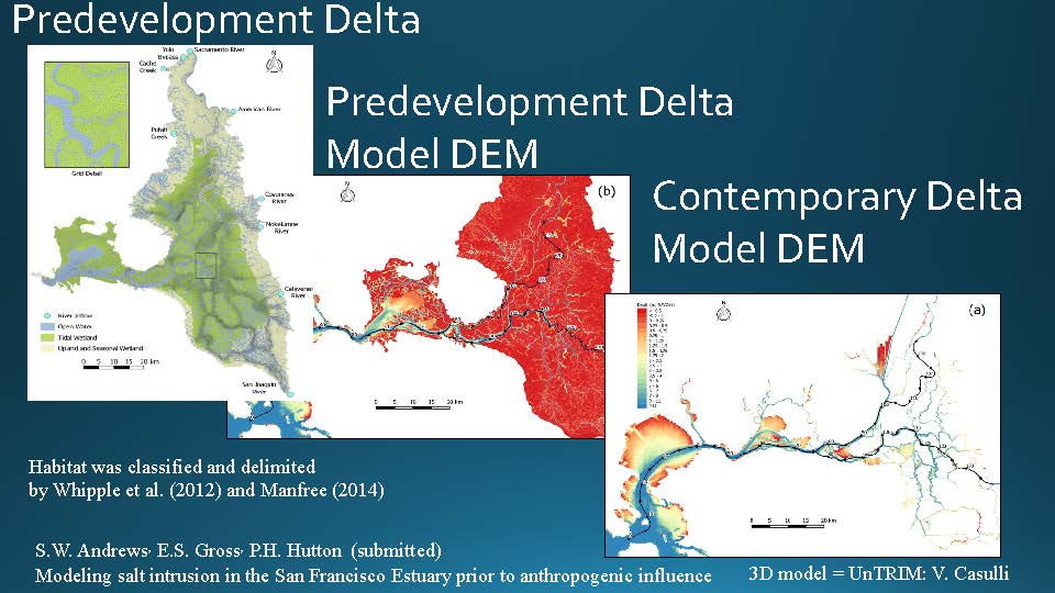 A lot of work has gone into this subject; there is the work from the San Francisco Estuary Institute, and the DEM by John DeGeorge’s group and UC Davis. Mr. Burau pointed out that the tidal marshes are represented in red in the DEM; the slide showing the contemporary Delta has much less.
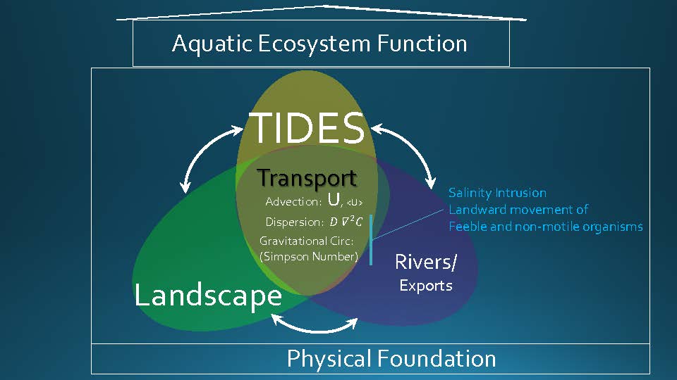 Mr. Burau then gave some basic information about transport in the Delta. He said he would be talking primarily about the tides because the change in the landscape primarily impacted the tides and did so in a very big way.
“The tides are a really big deal as this is primarily a tidal system, except when we have the big outflow events,” he said. “It’s the interaction of these three things – the tides, the changes in the landscape which is a little bit smaller than the tides but not much, and then the rivers and exports are even smaller in terms of their impact on transport in the entire system. Clearly when you’re up in the upper watersheds or near the pumps, these are a big deal, but when we’re thinking about the Delta as a whole, tides are the big guys, and it’s really that simple.”
These are three things that interact; Mr. Burau acknowledged that he is ignoring salinity for the purposes of this discussion, but salinity is also important. “These three things interact, and they provide this thing called transport. There’s advection which is the moving of things around by currents, the tides, and the net flows in the rivers … the difference between the pre-development and contemporary systems is really in that.”
There’s a lot of things he could be talking about with regard to the interaction of these three things, but for the purposes of this presentation, he will be focusing on two aspects of it.
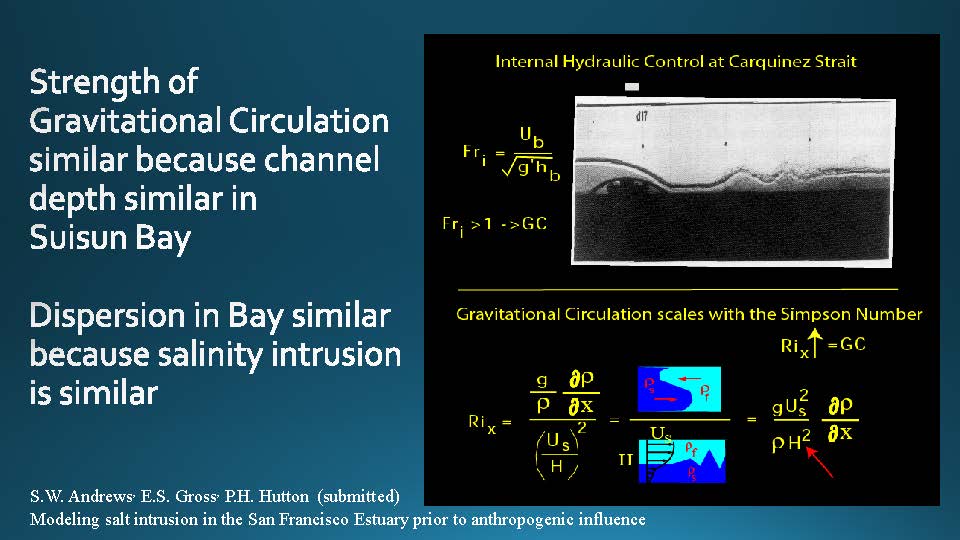 “We think there’s an internal hydraulic control in Carquinez Strait, and what that does is it mediates in some ways the amount of salinity that can get into the system, so that’s important,” Mr. Burau said. “And when I talk to the folks that did the DEM, the depth is Suisun Bay are roughly similar we think to what they were in the pre-development Delta, and so based on those two things, if you look at these figures, it turns out that because the depths are relatively the same. The amount of discharge coming in Carquinez Strait is almost exactly the same between the pre-development contemporary Delta so the velocities are about the same.”
The strength of gravitational circulation is similar because channel depth is similar in Suisun Bay, and dispersion in the Bay is similar because salinity intrusion is similar. “The Army Corps has done some salinity monitoring, they have a paper submitted, and they find that X2 varies about the same now as it did; it’s probably because of these scalings and some of the other things. So in terms of salinity intrusion and the way the Bay functions, things are pretty similar between the contemporary and pre-development Delta.”
The idea of the massive exchange of water from the channels onto the floodplain is another really key component for the comparison between the two systems, he said. “Basically the tidal energy between the pre-development Delta and the contemporary Delta is the same because Carquinez Strait is probably not only internally hydraulic controlled for salinity, it’s also most likely a surface water hydraulic control. What that means is the amount of energy that’s coming into the system is about the same, no matter what we do on the Delta side of things; so we have a finite amount of tidal energy and that’s because the cross section in Carquinez Strait is pretty firm ground.”
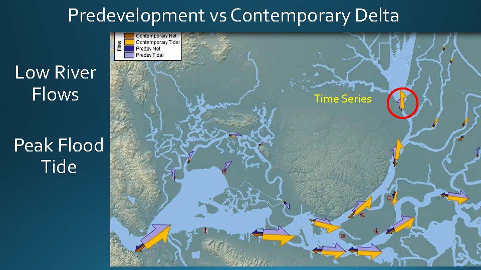
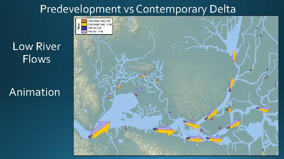 Mr. Burau said he, John DeGeorge and others have spent a lot of time looking at the tidal prism. He presented a diagram noting that the purple arrow is the predevelopment Delta and the yellow arrows are the contemporary Delta. He noted that the tidal flows going in and out of the Carquinez Strait are the same. There is a change of about 20% of tidal discharge between the predevelopment and contemporary Delta; if you look at the flood tide, the change in the San Joaquin River is relatively minor, and the change up the Sacramento is actually quite extensive.”
 Mr. Burau then presented a time series of the tides at Carquinez Straits, noting that certainly on the peak tides, they are almost identical. “On these weaker tides, there’s a little bit of a difference, but we wouldn’t expect the hydraulic control to work on the weaker tides, so pretty much, the tidal energy coming into the system predevelopment and contemporary is roughly the same.”
The take home message here is that there’s a finite amount of tidal energy coming into the system, and the tides are lazy – they go where the least path of resistance is. The distribution of tides in the Delta involves a minimization of system-wide impedance. “That means if we open up places for the tides to go, if they are near Carquinez Strait, they are going to go in there. If they are way in the back, they might not go in there, so this is really important for thinking about restoration,” Mr. Burau said. “The combination of these two things suggests that anytime we change the landscape, like we have historically or like we plan to, there’s going to be a redistribution of that tidal energy.”
The combination of the hydraulic control at Carquinez Straits and tides are lazy suggest the largest changes in transport involved the redistribution of tides in response to changes in the landscape. There are two big changes in the landscapes that can be seen in the numerical models: the massive dredging of Cache Slough in the Western Delta for taking care of the flood waters, and the effect of the loss of the tidal marshes.
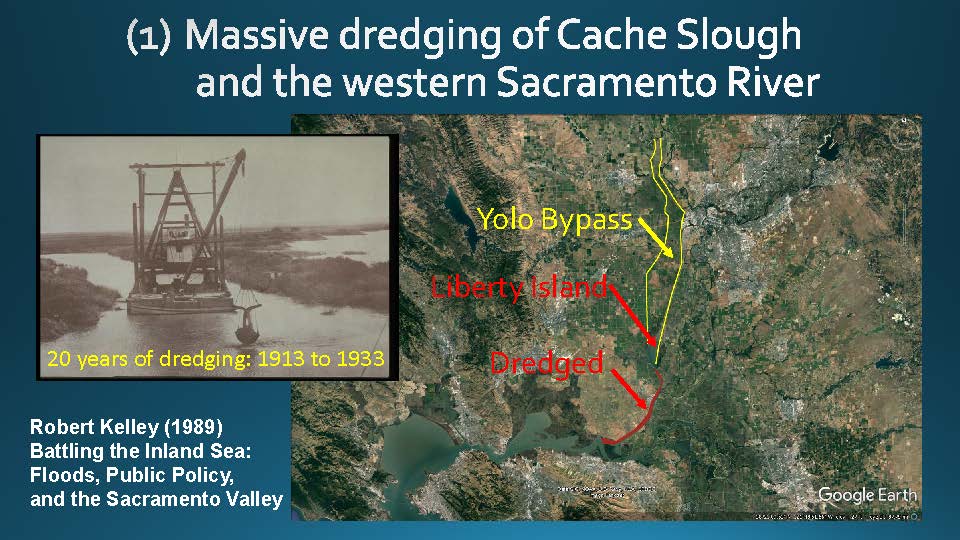 Mr. Burau reminded that for 20 years, there were dredges running 24/7, 365 days a year. “They removed more material than the Panama Canal, and the reason we did this is because of the amazing Yolo Bypass and Sutter Bypass, and in order to have the City of Sacramento and Davis, they felt they needed to open up Cache Slough and the western Sacramento River to be able to carry the capacities. So we dredged the heck out of this, made it wider and deeper and so forth, so that we could get these floods out of the Yolo Bypass and out of the Central Valley so we could keep our farms and cities. That’s a big deal. We talk about the landscape being changed, and certainly getting rid of the marshes is a big deal, but this is a big deal when you look at the model results.”
 He presented a slide from the model showing the differences between predevelopment and contemporary Delta, noting the big difference that exists primarily on the Sacramento River system. “This is Columbia River-scale river in a system that didn’t support that historically,” Mr. Burau said. “There is this big conveyance and this big amount of tidal prism, and so there’s a ton of water going through this particular system. If you look at the San Joaquin, it’s relatively the same. So this, in terms of the model results, is a big deal and it makes sense in terms of how much we modified the system.”
 He then presented a time series showing the flow patterns at Cache Slough and Ryer Island compared to the predevelopment. “Almost double,” he said. “This is a big deal. Now what’s cool about this is that we’re planning on restoring up in Cache Slough; the great thing is we have a conveyance system to get the tides up there. The bummer is the tides are lazy, and if one of the islands pops, the tides could go in there, so we need to be really careful when we think about restoration because the tides are finite, so it’s going to mean a redistribution.”
“So when we talk about the integrated effect on the entire system of the loss of tidal marsh, there is a big spring neap variability in the amount of inundation in the system, which means a redistribution of tidal energy,” he continued. “In the predevelopment system, this redistribution occurs at the spring neap time scale because the tides are lazy. On the big tides, it goes more into Suisun Marsh, because it’s right there and the overtopping of those little levees is the easiest place for it to go, so it goes there.”
Mr. Burau then turned to the idea of there being a spring neap variation in the pelagic and marsh habitat coupling,. “During the neap tides, there is some inundation of the marsh plains, but at the higher tides, there’s a lot more of it; there’s a lot more exchange between the pelagic and marsh habitats.”
Mr. Burau and Chris Enright did an experiment where they put an instrument in at first Mallard Branch in the Suisun Marsh as well as Sheldrake Slough which has the same tidal prism and the same tidal forcing. “This is one of those really lucky experiments and of course the important thing here is it’s is all leveed off and has this little natural marsh plain, which is right about at mean high or high water. So when we have our big spring tides and we go above that, all of a sudden the water in the channel has access to the marsh plain, and we get a big difference in the hydrodynamics.”
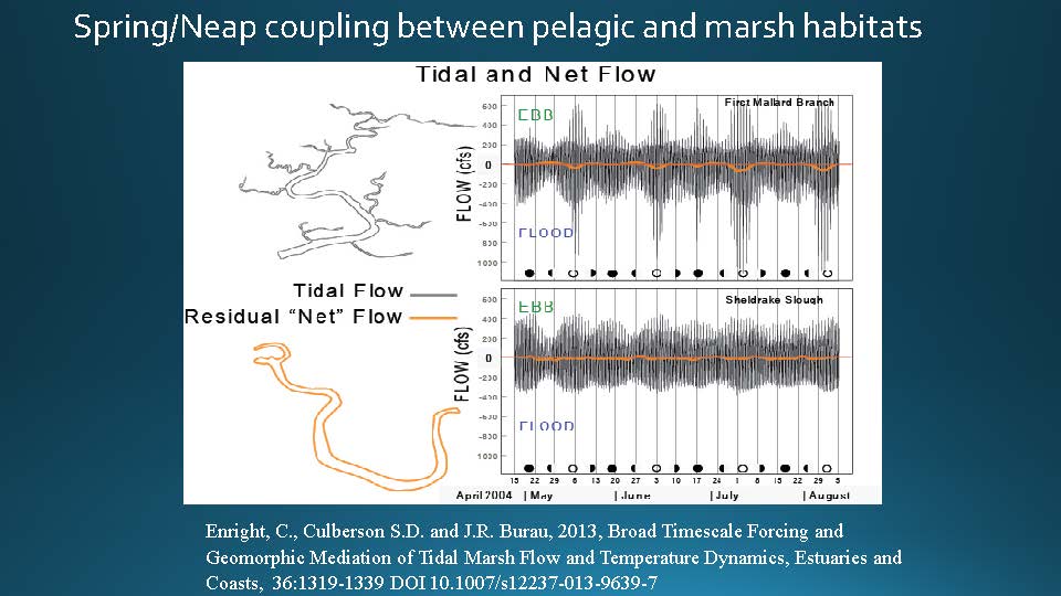 Mr. Burau presented a slide of the time series they collected at First Mallard Branch and Sheldrake Slough. “We have during these new and full moons, we have these almost doubling of the tides as the water flows out onto the marsh plains,” he said. “So when I first saw this, I called up Chris Enright, and said, something’s wrong with the equipment. I’ve looked at a lot of time series and I have never seen a time series anywhere else in the system where you see a doubling of discharge at spring tides or neap tides.”
In the contemporary Delta with all the levees, the pelagic and terrestrial habitats are always disconnected due to the levees; there is some spring neap variability, but nothing like a doubling, he said. “Seriously, you will not find a time series like this probably anywhere in the system now. Wildlands has a little bit, the restoration effort they did up in Liberty, but you’ll not find a series almost anywhere else in the system like this.”


Mr. Burau said that even though functionally it looks like a great place to be, the fact that it’s the only dendritic marsh out there without any other similar marshes next to it doing the same thing, means that when the tides go above mean high or high water, the tides go overwhelm the system and go everywhere.
In the historic Delta, aquatic and terrestrial habitats decoupled during neap tides, and coupled for four to six days during spring tides, so the pelagic ecosystem developed on the neap tides and fully advected into the marsh on spring tides. But in this case, the pelagic environment that was created here during the neap tides is completely blown into the marsh because these tides are so extreme. “So even though this looks like a great place, because there isn’t a bunch of marshes next to it that are sucking up the tides, it may not be functionally and probably isn’t going to be functionally the same as what we’ve got when we had the historical marsh.”
 Mr. Burau also pointed out that the large tidal exchanges at spring tides don’t occur uniformly throughout the Delta because again the tides are lazy. “If you look at the inundation regime at the spring tide, it’s really a lot in the Suisun Marsh,” he said. “Why? It goes into here first before it goes into the rest of the system. If you look at neap tides, it’s the same kind of thing, so the spring neap tidal variability near to this control is more than farther east in the Delta because the tides are lazy.”
He then presented a diagram done by John DeGeorge, noting that there’s a 20% reduction in the amount of exchange between the predevelopment and the contemporary. “What John did for me is he went into the model and he added up these exchanges here and did a comparison,” he said. “If you look at the predevelopment flow, tons of water is going into Suisun Marsh; if you look at the contemporary Delta, quite a bit little.


Mr. Burau also noted there is spring-neap variability. “On a spring-neap timescale, Suisun Marsh is doing its thing much more so than the rest of the system,” he said. “Now the rest of the system is doing this inundation, but not to the extent that Suisun Marsh is and not to the extent to the spring neap variability that Suisun Marsh is.”
To conclude, Mr. Burau said there are two things to know. “The tides are lazy and we only have a certain amount of it, so when we think about changing the landscape in a significant way, it’s going to mean a redistribution.”
 Sign up for daily email service and you’ll never miss a post!
Sign up for daily emails and get all the Notebook’s aggregated and original water news content delivered to your email box by 9AM. Breaking news alerts, too. Sign me up!
