

 Although the concept of ‘reconciliation ecology’ was articulated by Michael Rosenzweig in the early 2000s, the idea of coming together to resolve the challenges of human development and ecosystem health at the edges of the San Francisco Bay has been in play since the 1990s. The Baylands Ecosystem Habitat Goals project created a regional vision for the restoration of 100,000 acres of habitat, and since the report was completed in 1999, 8,000 acres restored to tidal action, and another are in the 30,000 acres in the planning stages. Currently, the Baylands Goals project is being updated, taking into account the possibility of a two to five foot rise in sea level by the end of the century.
In this installment of the 2014 California Water Policy Seminar Series, presented by the UC Davis Center for Watershed Sciences and the law school’s California Environmental Law & Policy Center, Letitia Grenier, project coordinator for the Baylands Goals update project, and Joe LaClair, Chief Planning Officer for the Bay Conservation Development Commission, shared how the Bay Area is preparing to meet the challenge of sea level rise while simultaneously protecting critical human infrastructure and restoring and protecting healthy ecosystems.
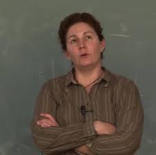
Letitia Grenier, Project Coordinator, Baylands Goals update
 Letitia Grenier began by saying that the Baylands Ecosystem Habitat Goals is a unique project, certainly in the US and possibly around the world, in that they have been collaboratively working on reconciliation ecology for a few decades now.
In the late 90s, a group of scientists got together and came up with a plan for the inter-tidal habitats in the San Francisco Bay, she said. “Even back in the late ’90s, San Francisco Bay Area was highly urbanized, and that urbanization meant that trying to do any restoration or enhancement of those inter-tidal or Baylands habitats was essentially reconciliation ecology,” she said. “Everything we’re doing is within a ring of people, and that ring of people essentially dumps all their trash and all their effluents and a lot of different things into the Bay, so those inter-tidal Baylands between the Bay and the upland are very much impacted by the people around it.”
“The Baylands Ecosystem Habitat Goals was this huge, collaborative, scientific report done in conjunction with the agencies that are responsible for permitting what happens along these areas around the edges of the Bay, and a lot of what I will be talking to you about is not just the science, but how do you take that science and make it effective? This is a really big piece of reconciliation ecology,” she said.
Scientists can end up talking to ourselves about science, but that doesn’t work for conservation biology, she said. “Somehow those messages have to get to the people that are making decisions on the land about what should be done or how should we source if we manage water, the land, wildlife, whatever it may be. And so I think one of the really interesting things about this project is that it’s a model for how you can do that,” she said.
Since it was first completed in 1999, we can now look back and see if it was effective and what we have learned, and decide where we want to go with it, she said, noting that the report is currently being updated with climate change considerations. “I’ll be leading you through a fair amount of detail about how it’s structured, what it is, and whether it was successful so that you can see that translation of science into management, which is one of the key features of this report and why we think it was effective.”
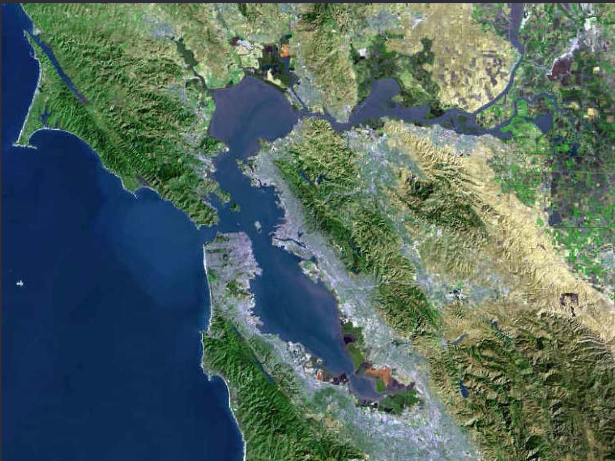 She then presented a slide of a satellite image of the San Francisco Bay Area, pointing out how the southern and central portions of the Bay are literally ringed by high-density development.
The 1999 report was very collaborative, she said. “Everybody who wanted to be a part of it was invited to be a part of it, and that means it’s a little bit slower and there’s a little bit more conflict,” she said. “But we ended up with more than 100 people working together to come up with this vision of what should we do with the Baylands,” she said, explaining these are the intertidal habitats, such as tidal marsh, beaches, and mudflats that exist around the edges of the Bay. She noted that it much like what was in the Delta historically, although there were some differences.
When the first Baylands Goals report was being prepared, she was in grad school at the time, but back then they tried not to let politics influence the outcome. “The idea was to say, “What is the best thing we could come up with from science, in terms of how we should manage these habitats?“,” she said. “The goal was ecosystem health, which is a little bit of a fuzzy term, but it was essentially supporting native wildlife species and communities so they could continue to evolve into the future. I think that is in keeping reconciliation ecology.”
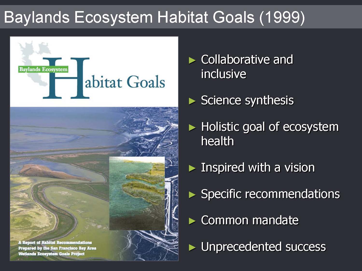 “One of the reasons I think it worked is that it provided a positive vision of the future,” said Ms. Grenier. “It said, ‘Here’s where we should go. This is the target we want to hit.’. And that was a lot easier for people than hearing, ‘Here are the problems, here are some things we might do, but I’m not sure which one.’ It said, ‘We have all gotten together and done this really kind of long and difficult process, and here’s the target we should hit.’ And that made it easier for people to go out and say, ‘My project is in keeping with this target, so you should give me money.’ And that seemed to actually work for many of the agencies that wanted to put restoration projects in the ground.”
The report also had specific recommendations. “It said, ‘If you’re on the north side of Suisun Marsh, here’s some areas you might want to think about restoring to these kinds of habitats,’ and that was helpful for people,” she said. “One of the reasons that it came into being was because there was conflict among the scientists. When you have some scientists saying you should make more managed ponds and some scientists saying we need to restore tidal marsh, then it’s very hard for anybody to do anything. But when the scientists have a common mandate and say this is the plan, we’re not arguing anymore, then that’s out of the way and it’s easier to go out there and get money and get permits to get things done. And it was an unprecedented success certainly for the Bay Area, but also for many, just in terms of any definition.”
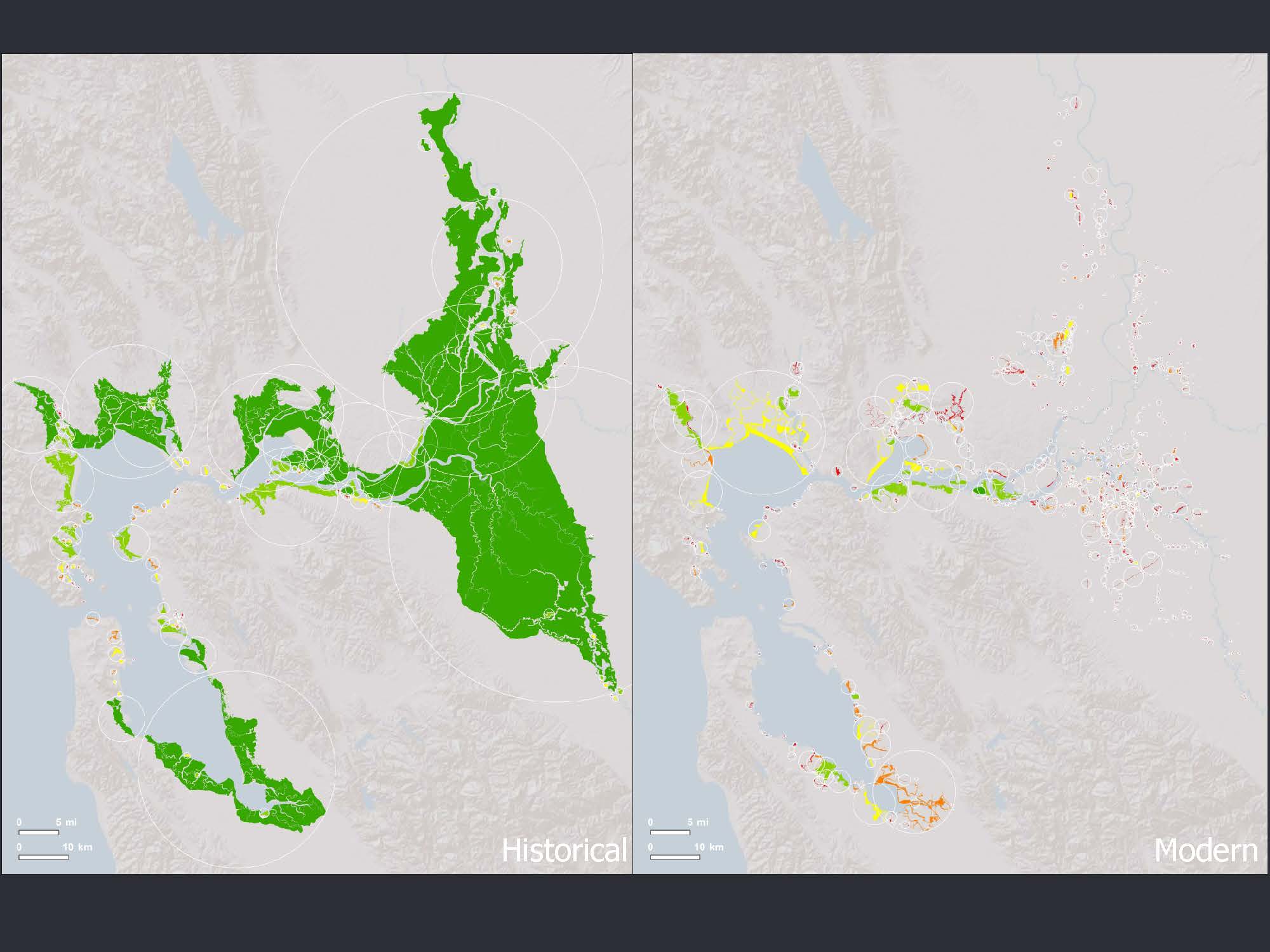
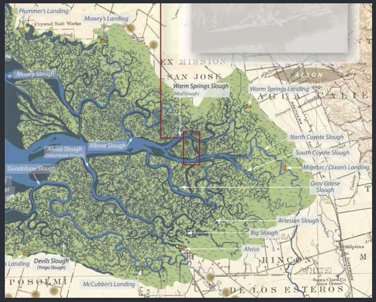 She then presented a historical map of the South Bay marshes where the Silicon Valley is now, noting that the green color represents tidal marsh that was present in 1800, which now is mostly gone. “These marshes had channels and dendritic networks of sloughs that were beautiful and full of wildlife,” she said. “One of the things the Baylands Goals did was detail some of those descriptions of what was actually going on in these places. … It’s the visioning and getting people’s hearts and minds entrapped in the ideas of what the potential is for this place. This is what it used to be, what do we want it to be in the future?”
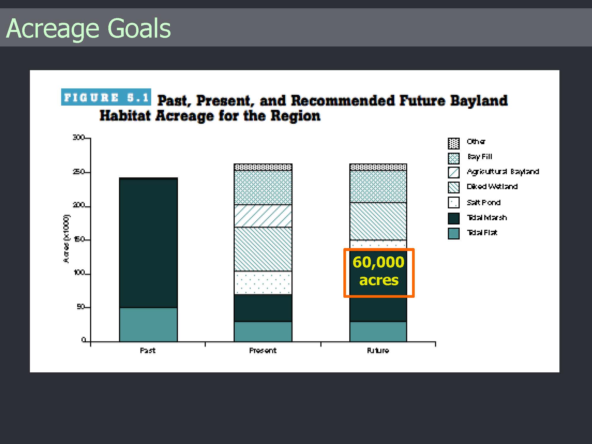 Another outcome of the report was to determine acreage goals, she said, displaying a slide titled, Past, Present and Future Bayland Habitat Acreage for the Region. She explained that they were able to use the recent historical ecology report to determine the historical acreage of different types of habitats, and satellite imagery to detail the acreage of the different habitat types present today; then they could decide what they wanted to do for the future. “And those were the Baylands goals which were how do we want to change the acreage?”
“The outcome of this essentially was to create 60,000 acres of restored tidal marsh,” Ms. Grenier said. “And that number was just astronomically large compared to what anybody had really thought of before, but it was based on trying to understand what did the native wildlife populations need to be self-sustaining and able to evolve into the future. A lot of that acreage was to come from reducing the number of managed ponds, which at that time were salt ponds that were largely owned by Cargill, and then also by reducing the ag land, mostly in North Bay.”
“So how did it actually work? It wasn’t really fast. It was slow,” she said. “There was a lot of conflict, because as you probably already know, there’s plenty to argue about in science, and so people were trying to work out some of those real conflicts about what do we do.”
She said there still a conflict between tidal marshes and ponds, explaining that there used to be a lot of wetlands in the Delta and Central Valley, but when those went away, they birds started to use the managed ponds which were created habitats in San Francisco Bay. Those populations became very reliant on these artificial habitats in San Francisco Bay which themselves were once tidal marsh. “So if we want to restore San Francisco Bay to tidal marsh, what happens to all those water birds that are now relying on those managed ponds? This is a real problem that is still being worked out, but at least the Baylands Goals came up with a framework that said, ‘This much for marsh, this much for pond, we can keep working this out, but let’s not let that hold up actual restoration projects going into the ground.’”
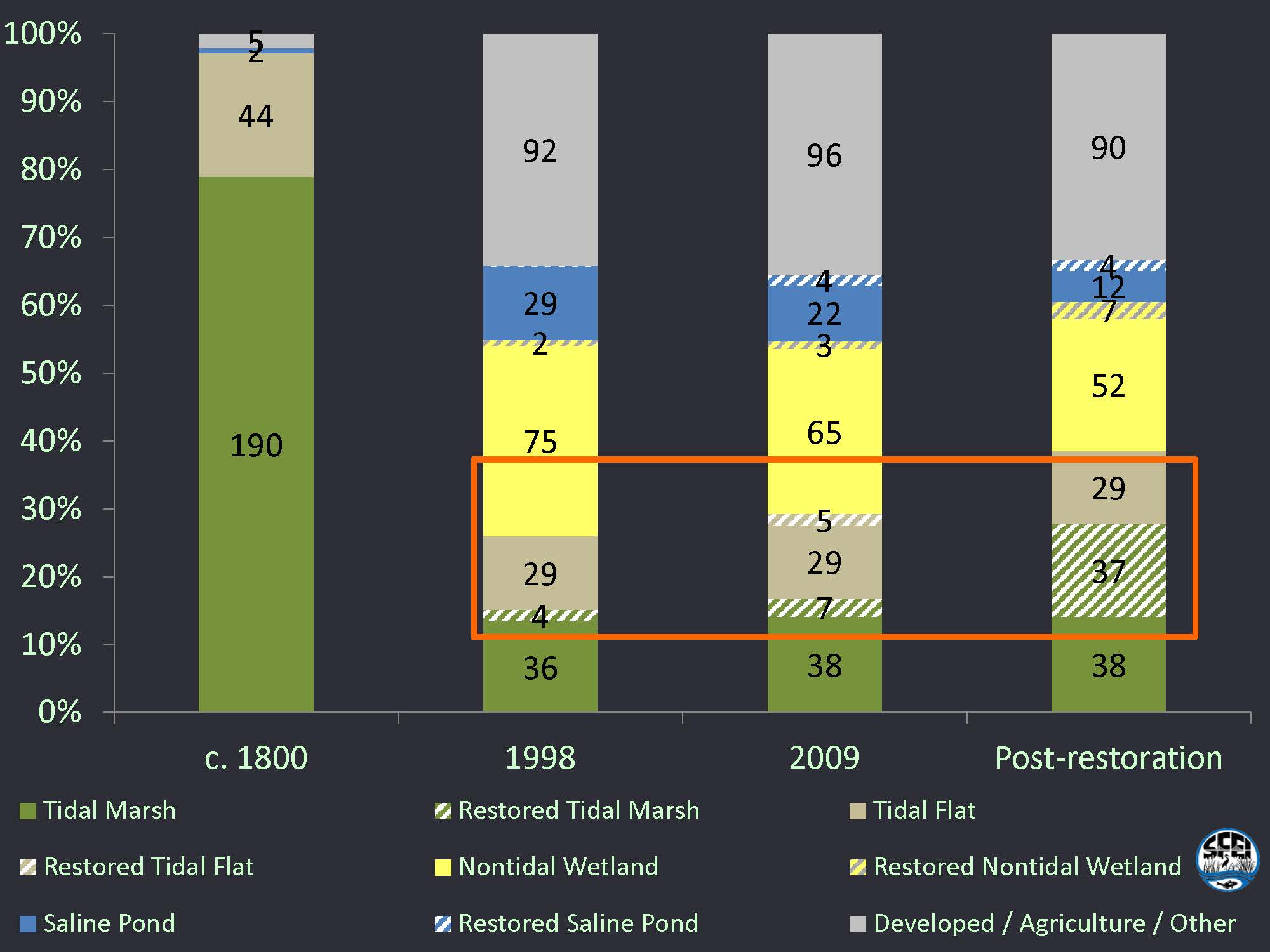 Ms. Grenier then presented a bar graph that depicted how much restoration had taken place to date, noting that the first bar show the historical acreage of different types of habitats, what habitats were there in 1998, what was existing in 2009, and then post restoration, which is they will have achieved if everything currently planned goes into the ground. She noted that there definitely is some estimation here, and it doesn’t include climate change which is going to be a big factor. “If you include the tidal flat restoration which will then evolve into marshes eventually, about 7,000 acres of tidal marsh restoration have already occurred in the past 15 years, and there’s about another 30,000 that will happen. So essentially we’re going to be more than halfway done with just the projects that have been planned in 15 years since that report.”
That amount of wetland restoration accomplished – so quickly planned, acquired, and done, was really unprecedented, she said. “The largest restoration project before the Baylands Goals was 350 acres; then it became 15,000 acres. So essentially the thought was that this process is what helped get Dianne Feinstein and other folks involved in getting real federal money to buy the South Bay salt ponds, and in also encouraging Cargill to sit down and have that negotiation. That’s the 15,000 acre South Bay Salt Pond Restoration project.”
“As scientists, we wanted to ‘fiddle’ with the goals, but the steering committee – the folks in charge of this project – said, ‘No way, you can’t change these. We have laws in DC that have these numbers written into them,” she said. “So this report was so important that it was written into policy even at the federal level and now we’re fairly well locked into it. It’s an interesting lesson in terms of climate change. You may not want to do acreage goals as you do this for the Delta, but it did seem to take hold,” noting that there’s been an increase in funding through various routes, and it’s also inspired other goals projects for both the watershed and for the sub-tidal parts of the Bay.”
In 1999, people were aware of climate change, but we didn’t have all the models and projections that we have now, she said. “Now what we have are models that have their own limitations, but they tell us, given what we know about how marshes evolve and accrete sediment, and given what we know about sea level rise and other changes in sediment supply in particular, what we think is going to happen with the amount of marshes that we have into the future, if we change nothing else, if we just let everything evolve.”
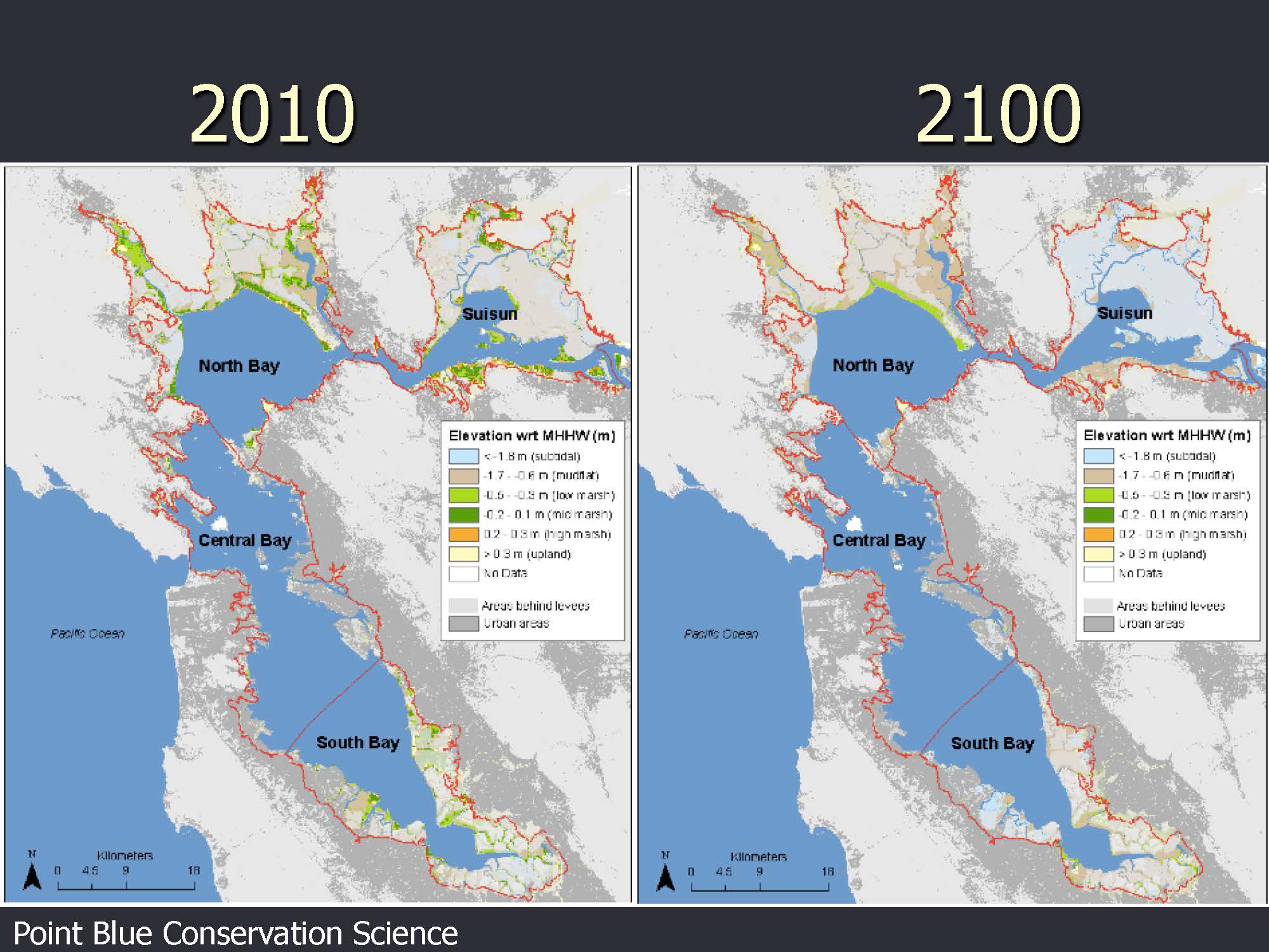 She then presented a slide which showed the bay area in both 2010 and 2100, depicting tidal marsh acreage that could be lost under projected sea level rise. “It basically shows that we’re going to lose a lot of our marshes over the next 100 years, according to this model.”
“Other groups have made other projections, and they all essentially get to the same idea,” she said. “The sea level rise curve is kind of flat right now. It’s going up, but it’s kind of flat, but it really starts to accelerate around 2060, 2070. And after that happens, it gets harder and harder for marshes to keep up. And so what that means is they end up getting lower in the tidal frame, becoming mudflats and then perhaps being gone altogether eventually.”
“That begs the legitimate question of why would we be bothering to do all these restoration and spending all these public money if these marshes are going to be gone in the end?,” she said. “So part of what we’re doing as scientists in this collaborative project is trying to answer that question, trying to understand what our options are and trying to decide. Is there evidence that we could actually avoid this future and come up with alternative futures that are more positive for ecology?”
The new report is called “The Baylands and Climate Change: What We Can Do” to emphasize that we think we can avoid the future that is projected by the model, Ms. Grenier said. “Part of being in an urbanized estuary is that we’re controlling how much sediment is coming out of these watersheds and where sediment that is dredged gets deposited, and how much water is coming in through different sources and what the salinity is in some of these areas,” she said. “We can really turn some knobs… Not everything we like to turn, but there is some management changes we could make that could affect what happens into the future.”
The report is going to present the state of science and also provide recommendations about what should be done, she said. “It’s very much focused on the effect of future change, especially climate change. And we’re talking a lot about habitat and about these processes and functions that are necessary to maintain the habitats,” she said. “A key aspect of sustainability in the long run obviously is resilience. What are the processes and functions inside these land forms and these watersheds and these Baylands that actually allows them to persist? So, for example, marshes have this process where they can accrete, but they have to have the right amount of sediment supply or they have to have the right amount of fresh water, whatever it is to be able accrete fast enough to keep up with sea level rise. So maybe we can affect that process by changing some of our management of sediment supply or water and then change the equation of how they keep up.”
Part of why we think this is an effective approach is that we have the right people looking over our shoulders, she said. “I can say this as a scientist. It’s really good that the folks who are on our steering committee are very knowledgeable about science, but most of them are agency people that are involved as stakeholders in how to manage the land, more than actually doing the basic research on the land,” she said. “Our steering committee are basically the users of this report, rather than the authors of the report. And so the users of the report are telling us how to structure it, what should be in it, some things that we can and can’t say, and that is an interesting tension between science and management – trying to get out the messages in the right way.”
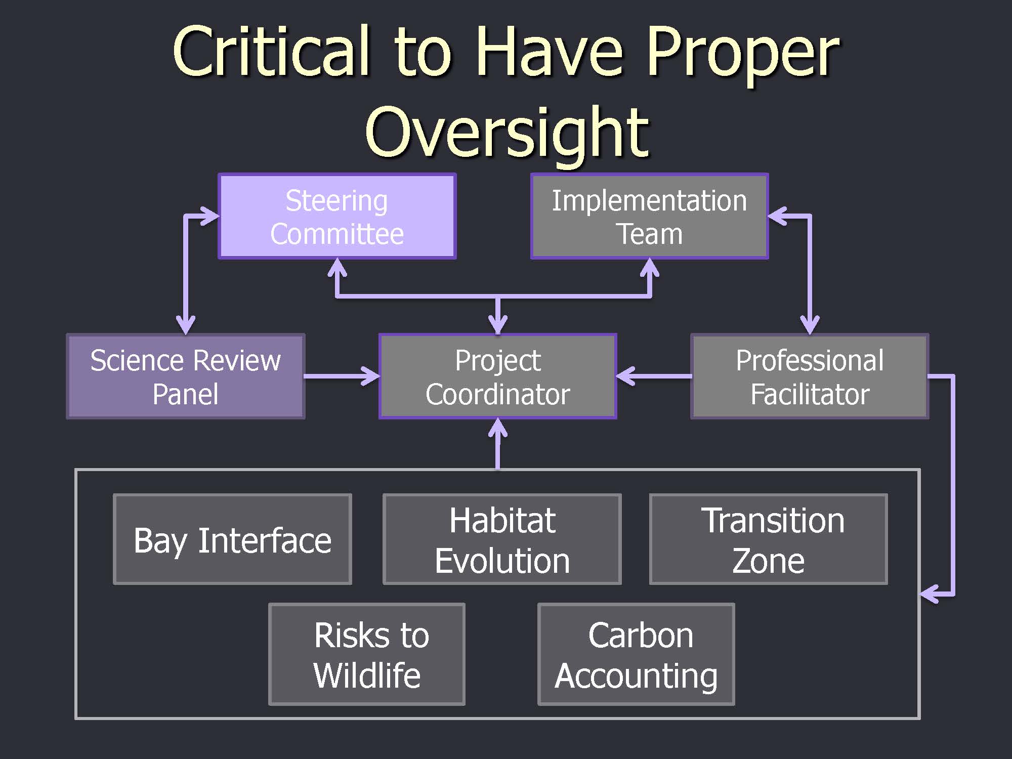 She then presented an organizational chart for the development of the report, noting that her position as project coordinator is in the middle. She said there is a Science Review Panel comprised of independent national level scientists that check up on what we’re doing, read the report at the different stages of development, and tell us where we’re not measuring up, she said. “That’s been really good. It’s really forced us to step up the quality of what’s in there,” she said.
It’s the people inside the box that are the actual engine of the report, she said. There are between 100 and 150 scientists on any given day contributing pieces of their work, editing drafts, and creating science chapters for the report, she said. They are involved with how the habitats will evolve over time, the interfaces between the inter-tidal Baylands and the Bay, and how the Bay and upland will also be changed by climate change, she said. “It’s a machine with a lot of moving parts, trying to figure out what’s going to happen.”
The upland area will become more important as the inter-tidal zone migrates up, because as sea level rises, what was once the upland area becomes inter-tidal, she said. “It’s a very important area, and it’s going to be a big issue with how levees are built. Who owns the land? How it’s managed? Can wildlife get out of the inter-tidal zone during these big floods that we’re expecting? Do they have any refuge area with plants? Are they up against a housing development with a sea wall?”
Another group is assessing risks to wildlife and trying to think about the biological processes and interactions and is mostly focused on physical processes, and there is a Carbon Accounting Group which is trying to see if wetlands can be used as a mechanism for getting more money to do wetlands restoration, she said. “This is really great because this might be a way that we can get the research done to find out how fast can we actually accrete peat, a big deal in the Delta where there are subsided lands.”
The steering committee is comprised of 26 people, which is a lot of people to answer to, she said. “It ends up being a really good balance, hearing a lot of different voices and coming up with the right product,” she said. “The Science Review Panel members are selected from experts in the different aspects of the report that we’re writing. so we figured out what we were going to be focusing on and then we went and found them and asked them to participate.”
The chapters are laid out and the report is structured into layers, with summaries of 50 pages to boil things down but also a lot of detail and evidence in the report as well.
Here’s another interesting point about the process and how to deliver scientific information in a way that people find useful, she said. “We’re offering the recommendations. What should you do about the Baylands in each part of the Bay for the next century? We’re offering them at several different scales. And here again, as scientists, we wanted to tinker with this and say, ‘We want to offer it at a watershed scale, and it would make more sense scientifically to do this by ecosystem or whatever,’ and the Steering Committee said, ‘No. We are organized around these sub-regions of the Bay and these segments of the Bay, and you need to tell us the science in a way that works for us, which is this way.’ And so that’s a really, another good example of the interplay between the information we want to get across as scientists and how it will actually be used.”
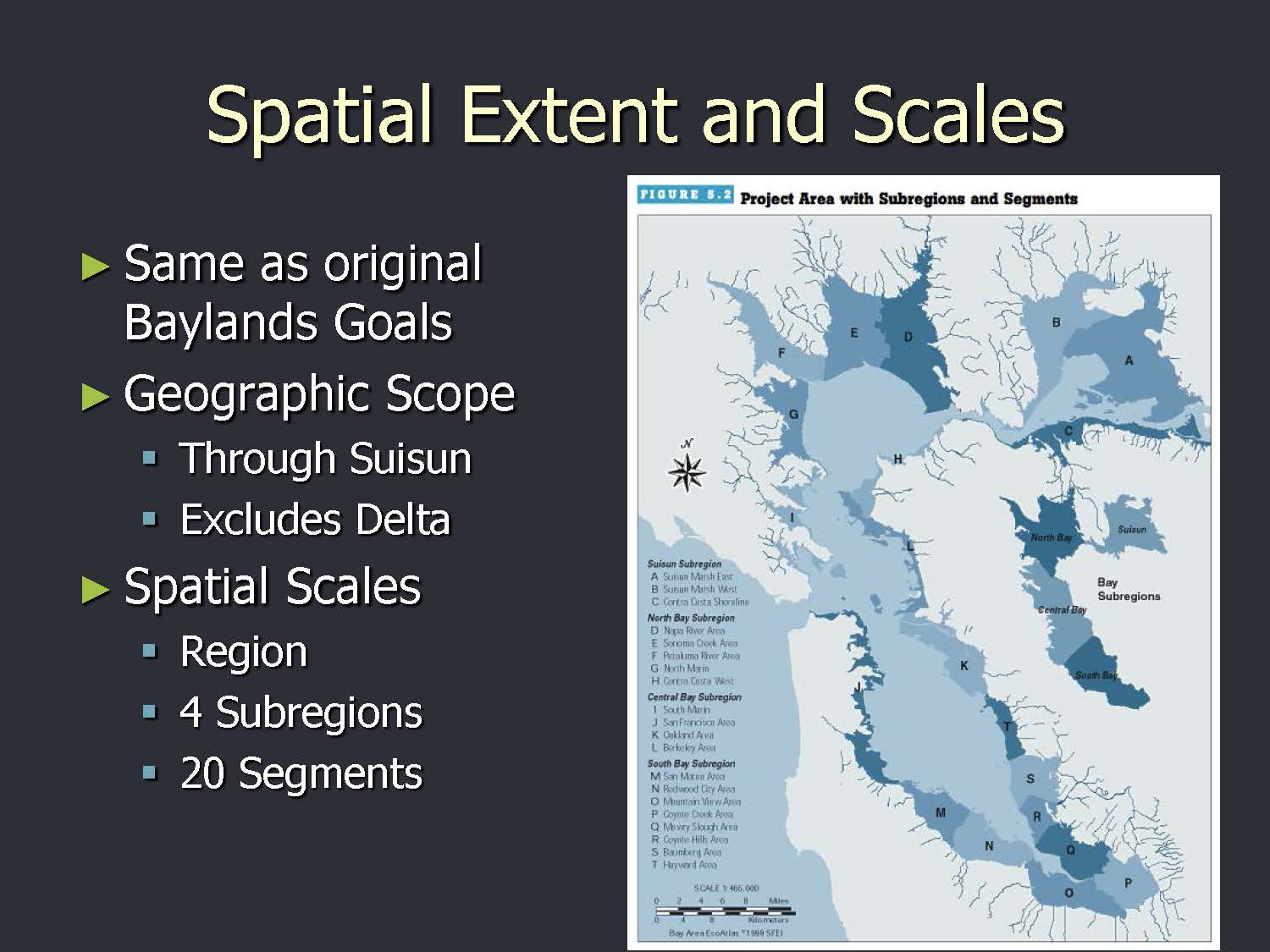 So there are regional level recommendations as well as overarching recommendations that are bigger than that, she said. There are four sub-regions: Suisun, North Bay, Central, and South Bay, as well as 20 segments that get right down to different reaches of the shoreline, she said. What are the different opportunities and constraints in each area?
The Suisun Marsh is kind of like the Western States in the U.S., she said. “We’re the last frontier. Everybody’s going to be looking to that land to reach their restoration goals.”
The report is mostly about drivers of change, she said. “What are the really key ones that we think are affecting the Baylands? Sea level rise is huge, and we’re trying to recognize it’s not just this little bit of change everyday, there’s a lot more complexity to how it’s going to change, when it’s going to change, and how fast it’s going to change. Temperature, precipitation. Some of these are more certain, like temperature. Some of them are less certain, like precipitation. And we’re trying to factor in the uncertainty as we think about this.”
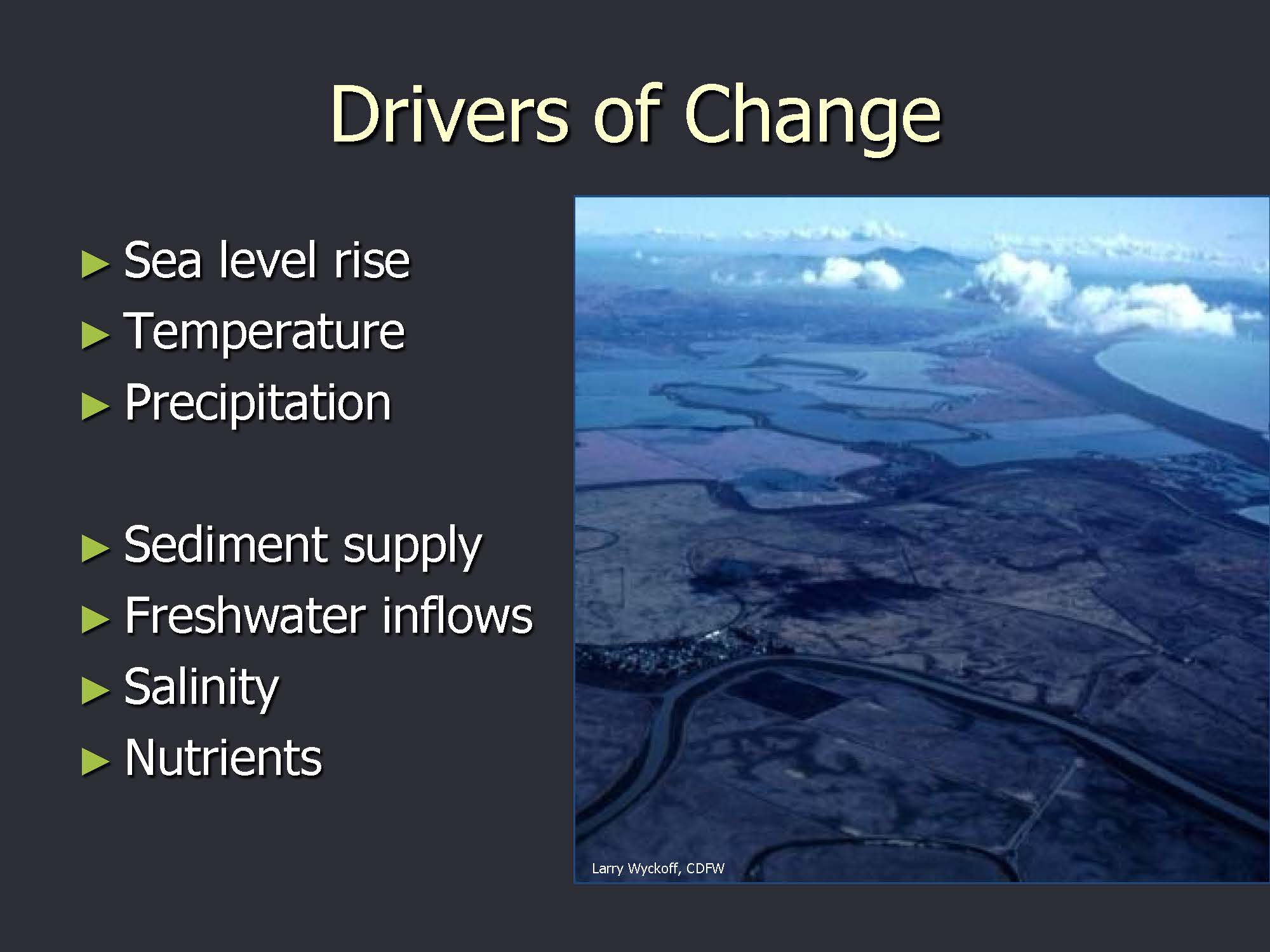 Sediment supply is a big deal and we have evidence from USGS that there’s less sediment now than there has been for several decades, she said. “But is that going to continue? Can we learn to take advantage of local sediment supply instead of being so reliant on the Delta? When the Delta Restoration Projects actually happen, will they suck up all the sediment and suddenly we’ll be getting a lot less coming into the Bay than we used to? These are really important issues coming up here with the drivers of change,” she said, noting that other drivers of change include freshwater inflows, salinity, and nutrients.
There’s an interaction between sediment supply and nutrients, she said. “As you lose your sediment supply, the water becomes clearer and you can have effects from eutrophication that you didn’t have before because suddenly they’re not as light-limited as they used to be. … So, there’s a lot of moving parts that we’re trying to think through as we envision the future.”
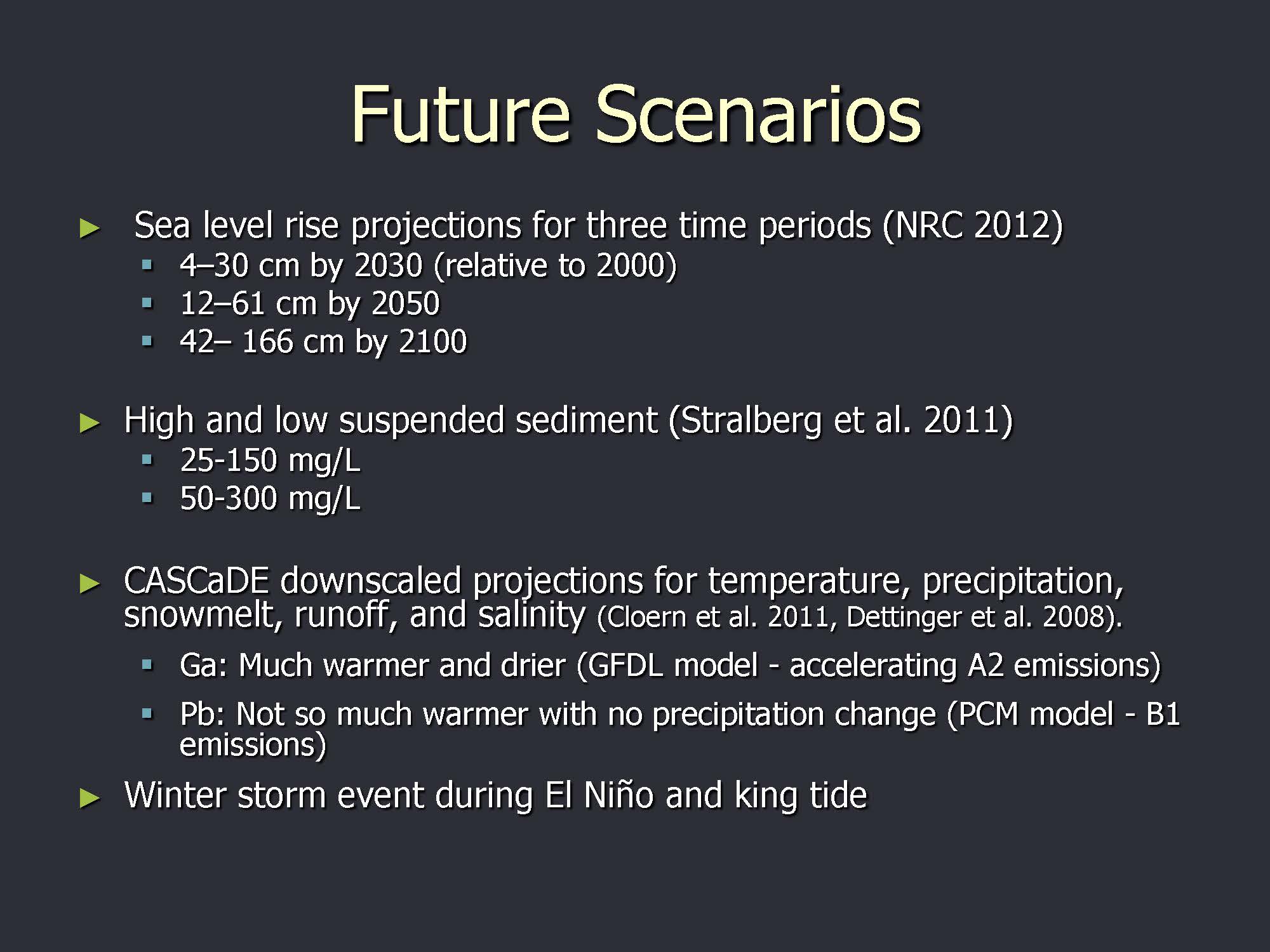 “Getting into the details of what future scenarios you want to think through is a really big job, probably more than we realize when we bit this off, and it’s very helpful,” she said. Five scenarios are being evaluated using both CASCADE projections from the USGS as well as some of the NRC projections for sea-level rise that the state agencies are required to use. “We’re really trying to use the best science and also be in keeping with what agency staff are going to be required to use as they make their choices, but it’s very complex and tricky, and it requires resources to get down to the details.” For example, for a storm scenario, what would be flooded, how long and how high has to be determined, but getting down to that level of modeling with the resources we have is essentially impossible, so there’s a lot of best professional judgment, she said.
We’re looking at sea-level rise and climate change and how that will affect habitat, but we’re also looking at event based scenarios, such as a big flood and what changes we would see in terms of population or geomorphology, she said. “The long-term scenario thinking is can we change that outcome?”
 In addition to habitats, we’re also thinking about processes and functions, she said. “The original Baylands Goals nodded to process and function, but it had goals that were habitat acreages,” she said. “If we had our way as scientists we would have actually gotten rid of those habitat acreages and said, ‘what we want is goals or processes and functions that can be measured by certain indicators.’. Unfortunately, we’re not able to go all the way there, but what we are trying to do is instead of seeing these as static land forms that are just there, understanding what is it that created this land form and how would you manage the land to make that sustaining to the future or to change it back.”
She gave the example of barrier beaches. “We’ve lost a lot of barrier beaches, so are there things we can do to restore the processes that allow sand to move through the Bay and create these barrier beaches? And the answer to that one is probably not, but maybe we can just plop the sand back there and then how long would it stay? We’re really trying to be innovative and go beyond where we were 15 years ago, and really use the best available science which means we have a lot of uncertainty.”
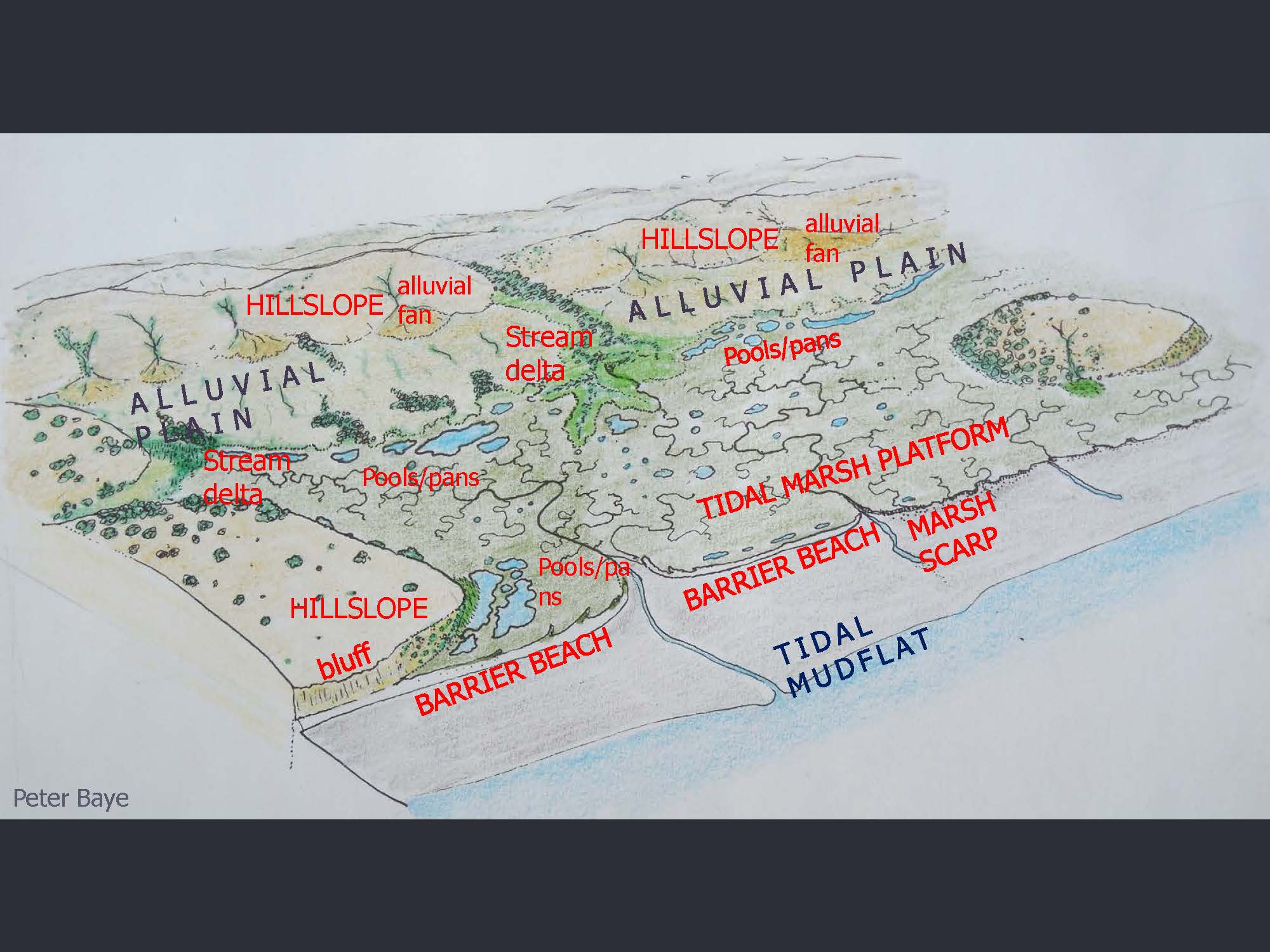
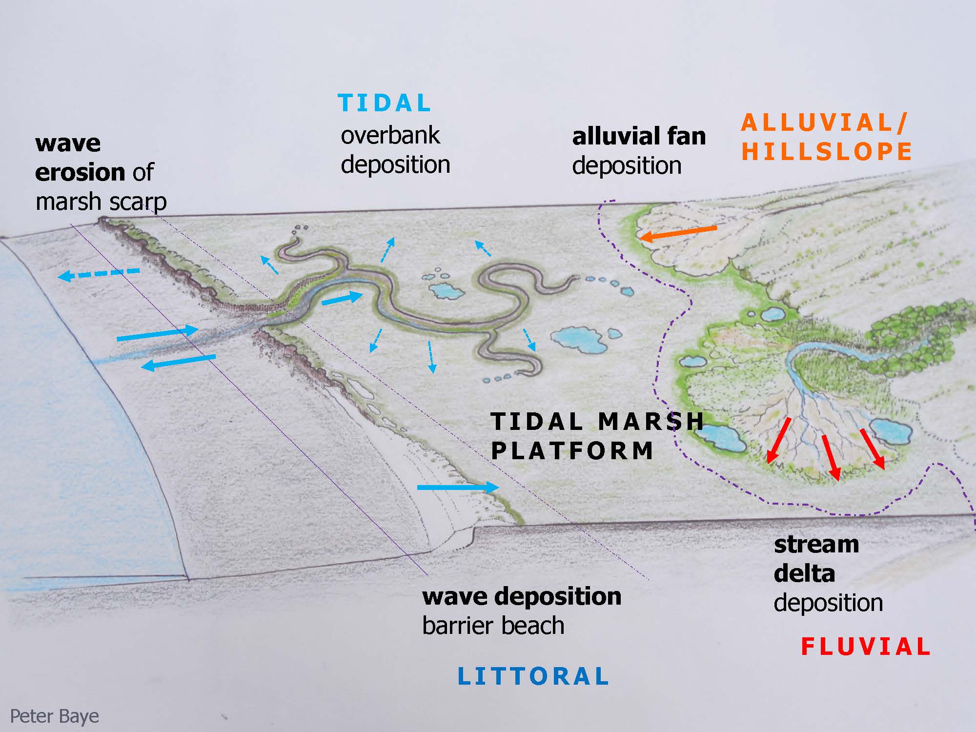 She then presented another slide, noting that it is a similar view of the same area in the previous slide. “Getting away from habitat all together and just thinking about what is it that makes these Baylands happen, you have deposition from stream deltas, and you have deposition from the wave – it’s not just one tidal marsh platform that you can think of all as sort of the same thing everywhere. You’re going to have to think of all these processes to consider how you can maintain it and how you can allow it to be resilient via the way it sort of wants to work naturally.”
Trying to do cutting edge science with brand new challenges from climate change is a hard thing to do, she said. “We are not ready for this policy-wise and, in some ways science-wise – we don’t know everything we’d like to know,” she said. “We have these recommendations that are going to say you should do things that you’ve never tried before. You should spend public money on experimenting with thin-layer deposition to allow marshes to accrete more quickly. It’s a fine line to walk between best professional judgment and sort of crossing that line between what’s too new to be acceptable.”
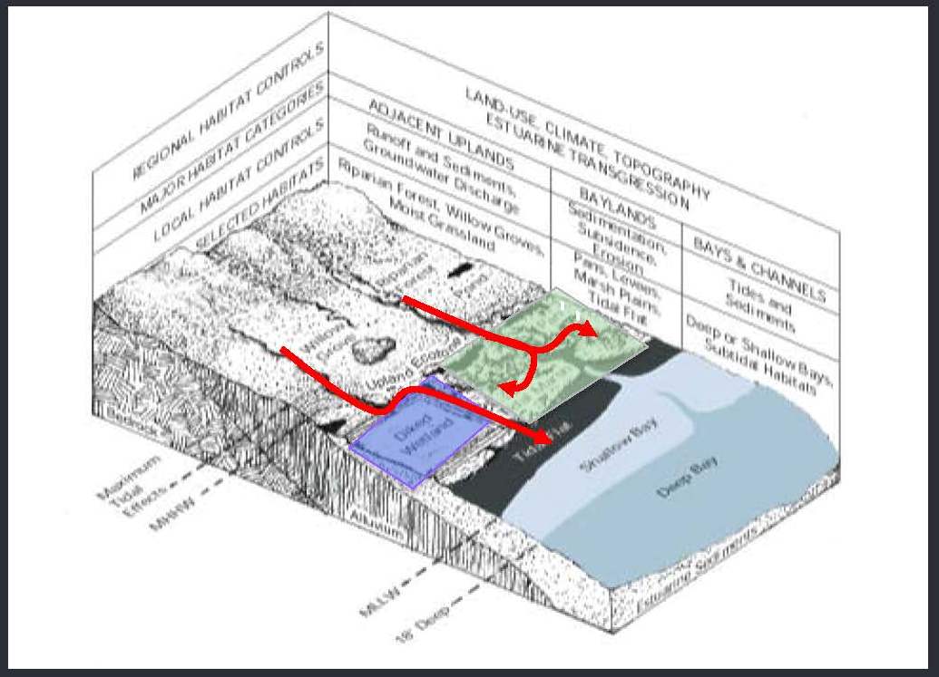 Ms. Grenier then presented a slide of a cutaway of the Baylands, from the deep Bay to the adjacent uplands, noting the tidal marsh area in green and the diked wetlands or managed ponds in purple. “What we’ve done with the water that comes off the watersheds, a lot of it’s somewhat contaminated nowadays unfortunately, but what we’ve done with it is just shunt it between levees and it just goes straight onto the Bay, and that’s a good solution for water quality because it gets diluted immediately into the Bay. It doesn’t go into the back of a wetland where then it could create problems if it’s not the cleanest water.”
“What we think we actually need to do now is restore that more historic condition of having our watershed water, even if it’s storm water or waste water treatment plant water, whatever that water is, when it’s ready to go out into the Bay, to have it come into the back of marshes where it can create gradients from freshwater marsh to brackish marsh to salt marsh like we used to have,” she said. “You get more rapid accumulation of peat and you get this potential refuge area where animals can get out of salt marsh and into other kinds of marsh and up to slightly higher elevations if they need to, rather than having your marshes backed up against the levee. The key thing is that you’re getting the sediment that’s coming out of the water and your watershed, and you’re using it to nourish your marsh instead of dumping it straight on to the Bay.”
As a historical condition, it makes a lot of sense, but since the watershed has been modified so much, the hydrology and quality of the water can be problematic, she said. “This ends up actually being a really big deal, trying to figure out how to do something that was the natural condition. Even just getting permits to do that is really hard. So, in this interesting position of trying to kind of figure out how to engineer the Baylands, in some ways, back into a more natural state so that they can be resilient, it involves a lot of new challenges.”
 Ms. Grenier then said she wanted to show some of the differences between the Baylands or the Bay, and the Delta. Historically, the Delta was a bigger marsh area than the Bay; the Bay was much more of a mix of open water and mudflats, but it was the Delta that had more marsh, she said. in terms of patch size, they were bigger patches than the Bay. The nearest neighbor distances were smaller, so it was much bigger and more connected, and it even had more core area, she said. “But there’s so little of it left now that we have no reference to work from about what this place used to be like,” said Ms. Grenier. “We have all these wildlife that evolved here. Even if it’s only for 3,000 years, there’s a lot of evolution that can happen during that time. So how do we reconcile this landscape with the wildlife that evolved here?”
“I’ll leave you with a couple of ideas about how to do that,” she said. “Build your science communication for the users; don’t build it for yourself. If you’re trying to get it to those users, you have to actually ask them for what they want. Inspire people with something positive,so they have something hopeful to work toward. Collaborate to create a science mandate, so that the scientists aren’t arguing with each other, because that just creates complete gridlock and nobody moves forward.”
“A couple of ideas that we are working on for our next steps is to try to implement the recommendations of the Baylands goals through infrastructure updates. Also partner with stakeholder agencies, which means partnering with people who have the money. So, the flood control agencies have some money. The waste water agencies have even more money. Because we’re not going to do this on the back of the Nature Conservancy and the World Wildlife Fund. We have to look outside of some of the conservation biology folks. And thank you to those who supported the project.”
Joe LaClair, Chief Planning Officer for the Bay Conservation and Development Commission
 Joe LaClair with the San Francisco Bay Conservation and Development Commission (BCDC) then took floor. He began by explaining that the BCDC is the first coastal management agency that was created in the United States, and it was formed because of the haphazard filling of San Francisco Bay in the 1960s. “Three women convinced the legislature to pass a bill to create this agency that manages San Francisco Bay as an ecological unit,” he said. “We also have a responsibility to promote wise development around the edge of the Bay, so for ports, airports and other marinas, and all kinds of things that need to be or can be on the Bay, our job is to issue permits for that kind of development.”
 When the BCDC was created in the 1960s, there was this concept that you could have a permanent shoreline, because no one really understood at the time that it was a dynamic bay that was changing, based on historic sea level rise rates, he said. “We all thought that you could just build the shoreline, and it would stay there,” said Mr. LaClair. “We’ve learned otherwise that it’s actually a growing Bay, despite the fact that what’s been put in place is to deal with a shrinking Bay. Because of sea level rise, we’re going to have flooding issues in San Francisco Bay, including areas that aren’t now inundated are going to become inundated; those that are infrequently inundated are going to be experiencing more frequent inundations, and some of those will become permanently inundated areas. We’re going to have longer lasting floods and stronger storms… There’s gonna be a variety of things that are going to happen in the Bay. We need to prepare for that through planning.”
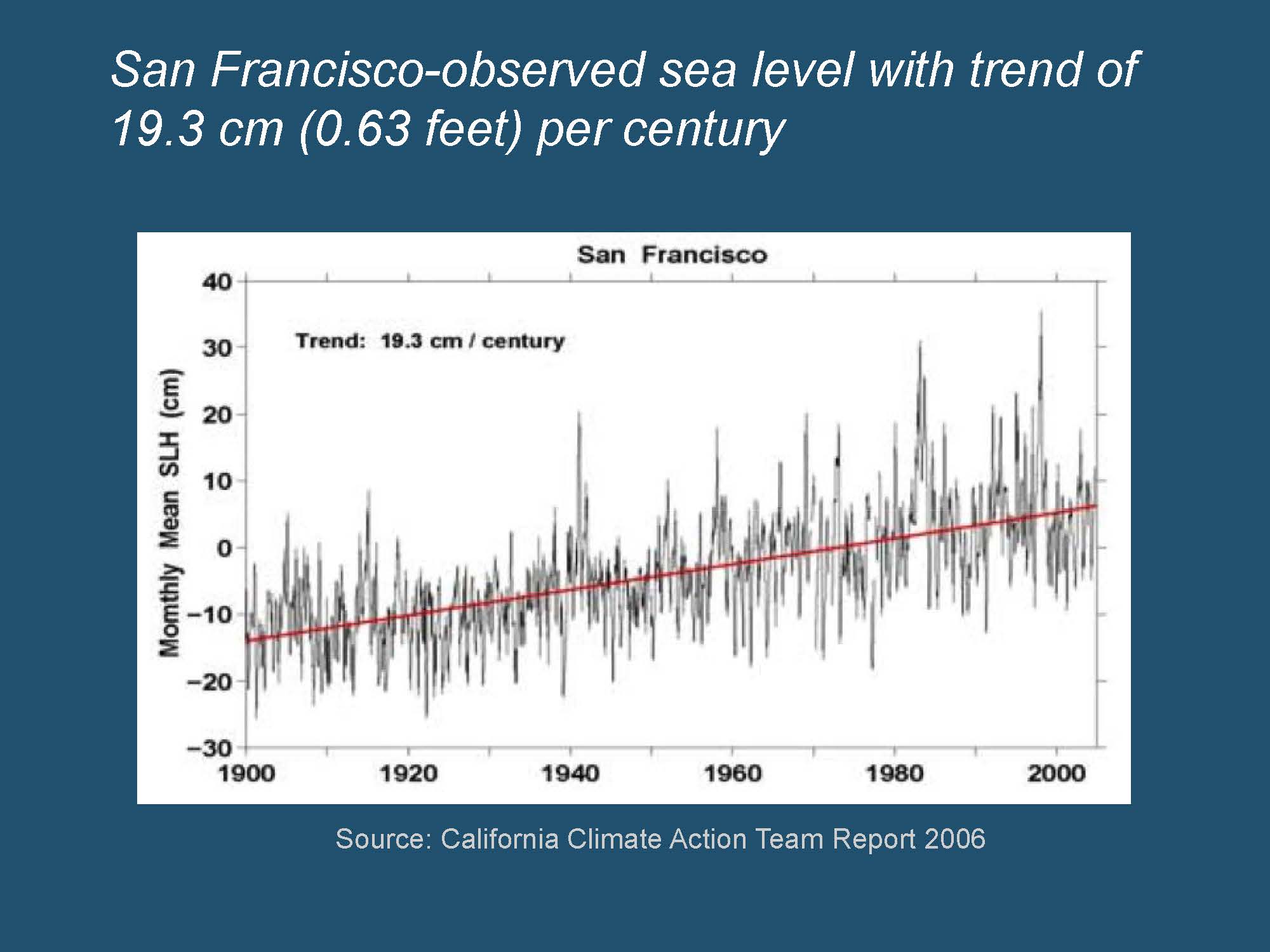 “The interesting thing about this graph is that it shows sea level rise, but it’s not a projection; it’s history,” he said, presenting a graph of sea level rise from 1900 – 2000. “We know that sea level’s been rising in San Francisco Bay, because there is a tide gauge at the Golden Gate, and it has measured about eight inches of sea level rise over the last 100 years.”
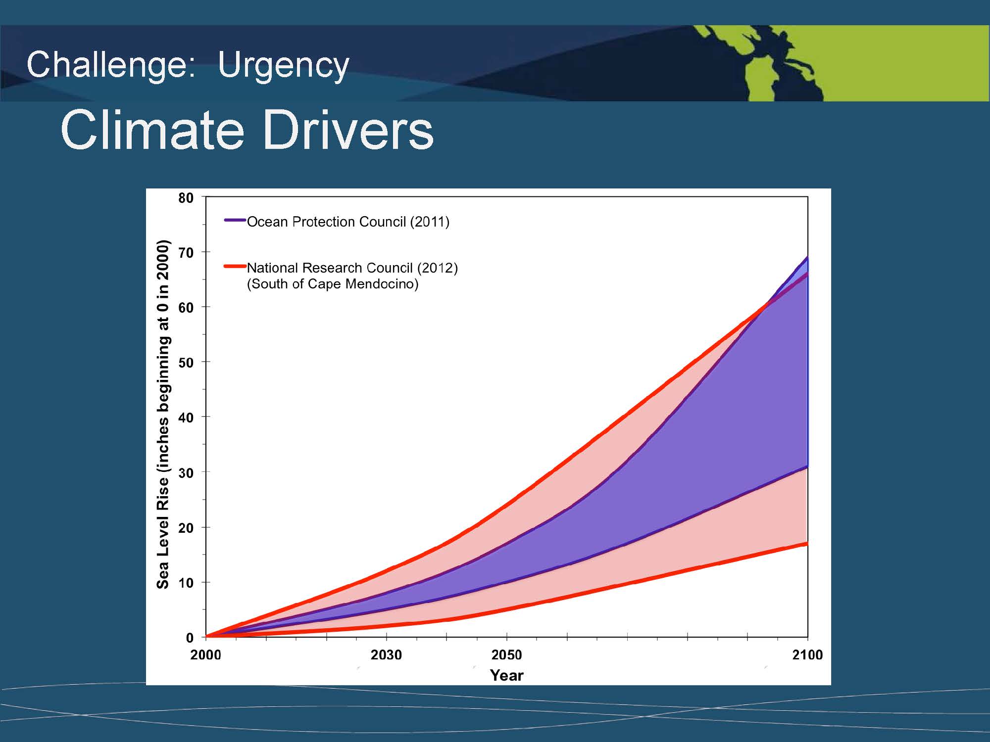 He then presented a graph of projected sea level rise, showing the Ocean Protection Council’s projections in purple and the National Research Council’s broader projections in orange. He noted that most recently, the IPCC’s report projected a meter of sea level rise by the end of the century. “Although many scientists feel that’s conservative and it doesn’t take into account the variability that we’re likely to experience, it’s the kind of number that people can wrap their head around. And about a meter, it’s about the size of a door, something that people can really understand.”
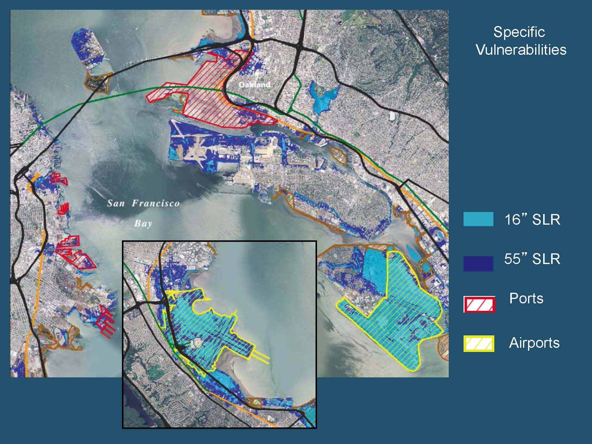 Adaptation is the kind of work we’ve been doing at BCDC, he said. “We used 16 inches and 55 inches of sea level rise as mid and end of century projections to look at the impacts that might occur in San Francisco Bay in the urbanized area, what I call the dry side of the levee,” he said. “What we learned was that there was about 280 square miles of land, pretty much the land we filled over the last 150 years that is vulnerable to sea level rise. It’s $62 billion worth of development and it affects things like our airports, Oakland and San Francisco, our seaports, almost all of our freeways and rail lines, neighborhoods, you name it – it will be affected by sea level rise in San Francisco Bay.”
“To address sea level rise, our commission voted a little over two years ago to amend the Bay plan, to update its sea level rise policies, and to require that projects, including wetland restoration projects, have a strategy,” he said. “First, that they do a risk assessment to assess what the risks to the project might be from projected, science-based sea level rise projection from mid-century. So, they have to design to mid-century, and then they have to have an adaptive management strategy for a science-based projection of sea level rise for the end of century. That was a big change for folks in the Bay area in terms of the kinds of planning that they had to do for implementing large projects around San Francisco Bay.”
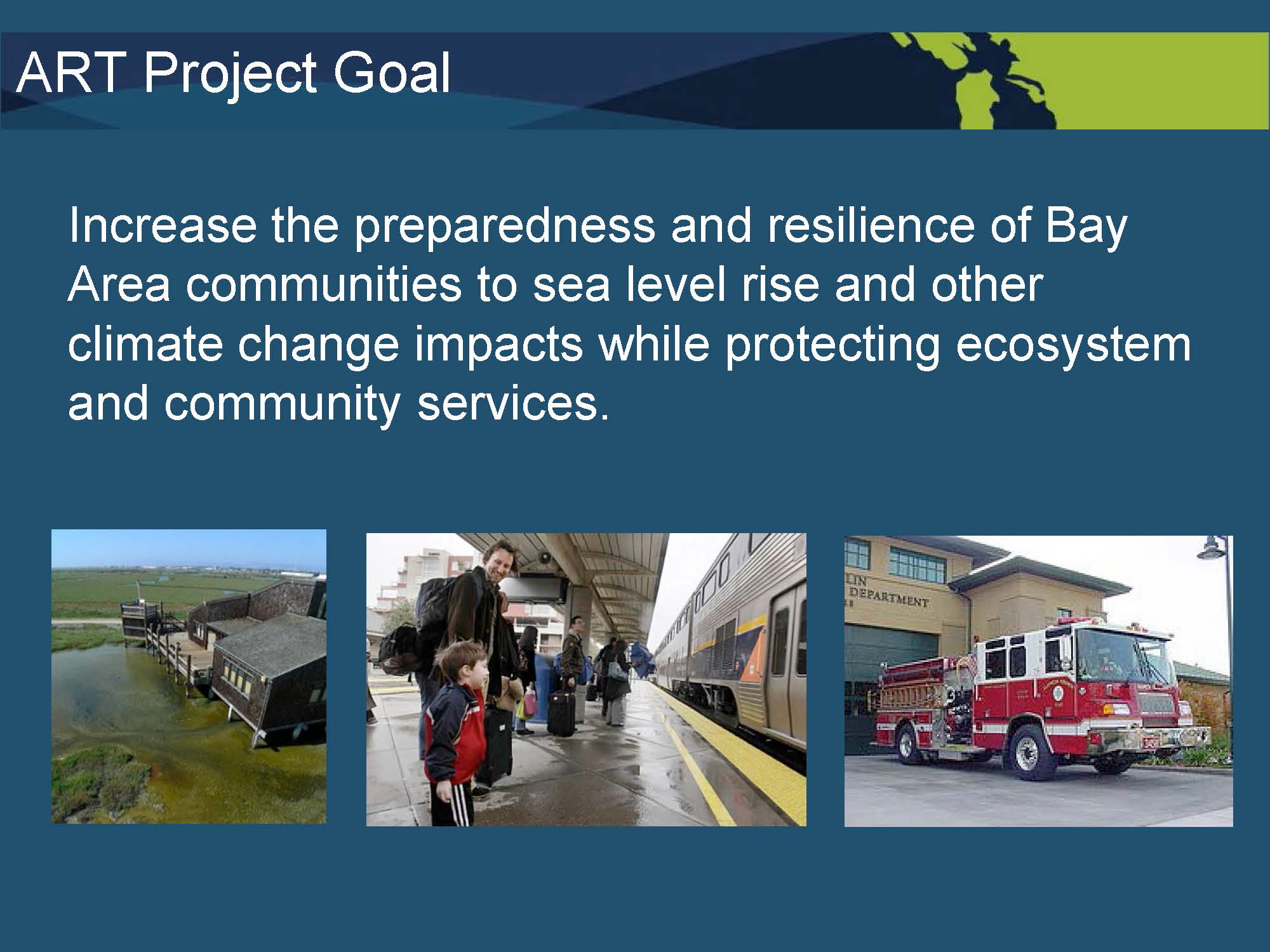
“While we were finishing this policy project, we spun up an adaptation planning project to build the tools that would be needed in order to conduct adaptation planning around the Bay,” he said. “It’s not something that we knew how to do or that local governments in the region knew how to do. So, the goal of the project was to increase the preparedness and resiliency of Bay area communities to sea level rise and other climate change impacts while protecting the ecosystem and community services. So, how can we address both, what I call the wet and dry sides of the levee together, so that we keep our ecosystem whole and at the same time protect communities?”
 The project is called the Adapting to Rising Tides or the ART project. Mr. LaClair explained that the project focused on a particular area with vulnerabilities to sea level rise, and then came up with viable adaptation strategies to address those vulnerabilities. “But we also wanted to come up with a recipe, a replicable process, that could be used by others both in the Bay area and around the country to conduct this kind of work because it’s new, it’s different, and people haven’t done it before. We needed to have a proven system for doing it. So, that was an important part of the project, and of course, to work with our stakeholders in the area to make sure that whatever we came up with reflected their interests.”
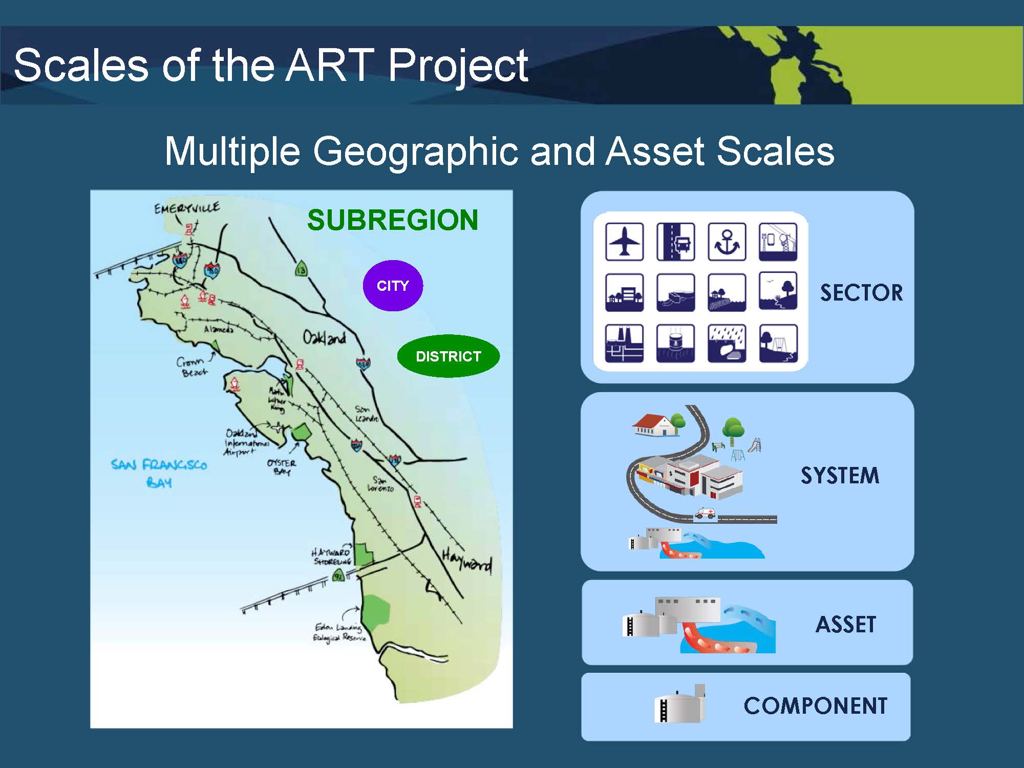 The project focused on the shoreline area from Emeryville in the north to Union City in the south, spanning six cities and a number of special districts, he said. We worked in a variety of scales within the sub-regions and we looked at sectors – we had to look at all those different scales in order to understand vulnerability, he said. The assets we looked at included airports, seaports, community land use areas, parks and recreation, natural areas, energy and transportation infrastructure, contaminated lands and hazardous materials, as well as stormwater and wastewater. “Our stakeholder group asked us to look at all of these,” he said. “I was opposed to it because it turned out to be a ton of work, but this is really the complexity that you have to grapple with if you’re going to do resilience planning where, at the end of the day, all these different kinds of things are affected… Everything from your wetlands and shoreline protection like levees and sea walls to sewage treatment plants and schools and hospitals and everything.”
The project had many partners, including the NOAA, all of the cities and special districts and other experts that helped us with the work we needed to do, he said. We used a planning model developed by ICLEI For Sustainable Communities, an NGO that focuses on resilience planning, he said.
In applying the model, we learned we needed to add a defined step that was the transition between understanding or identifying what the vulnerabilities were and how you develop adaptation strategy, he explained. “It was a kind of a classification and categorization process for characterizing the vulnerabilities, so that you could more easily step into strategies that would actually address them.”
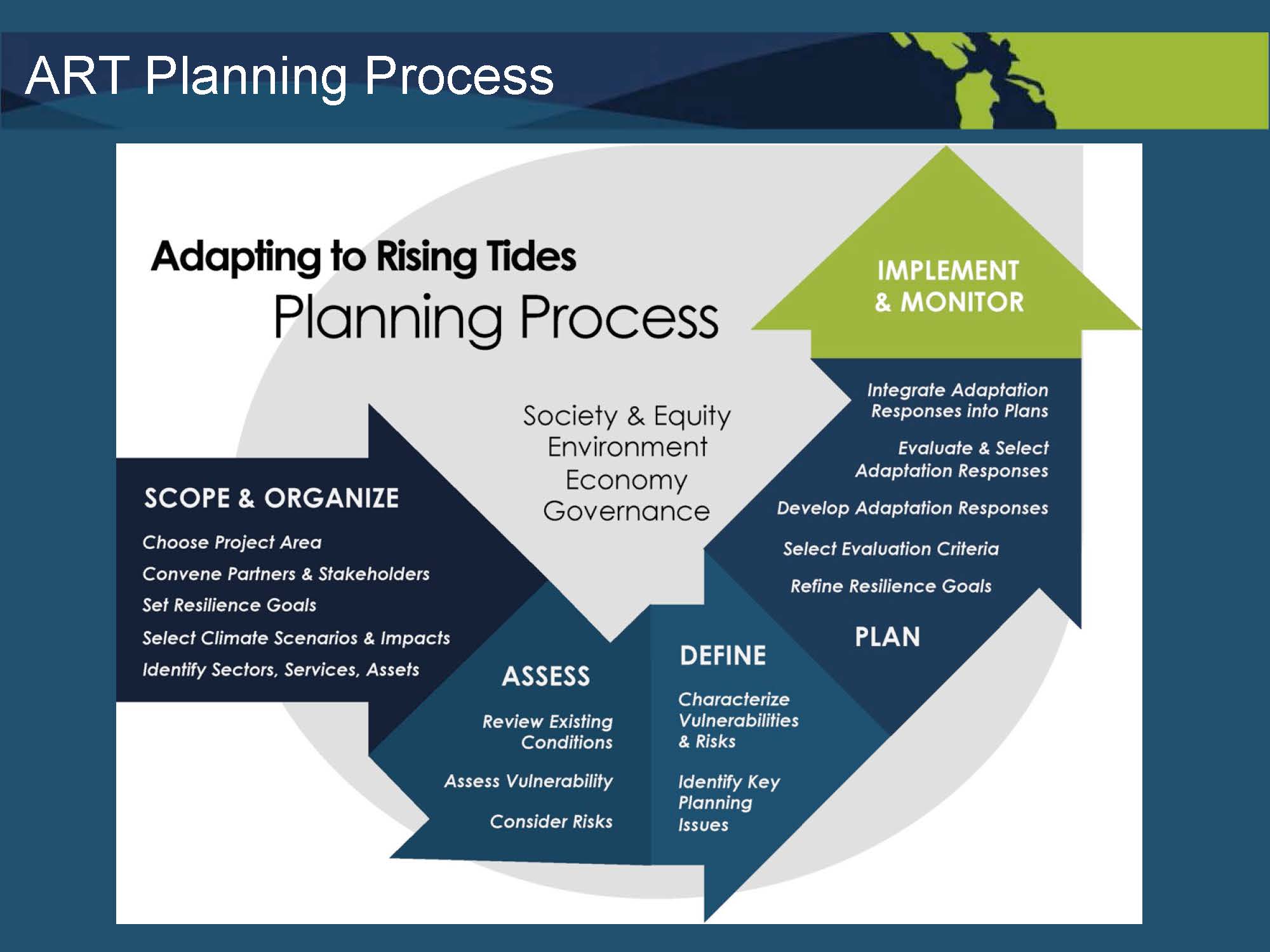 The planning process had four steps. “The first step is to scope and organize; that’s to pull together your team,” he said. “Who are your experts? Who are the stakeholders that you need to work with, and what data do you need to conduct this work? Defining data is one of the hardest things that you will encounter in the course of trying to conduct this work, so it’s really critical that you have an approach that enables you to get the information that you need.”
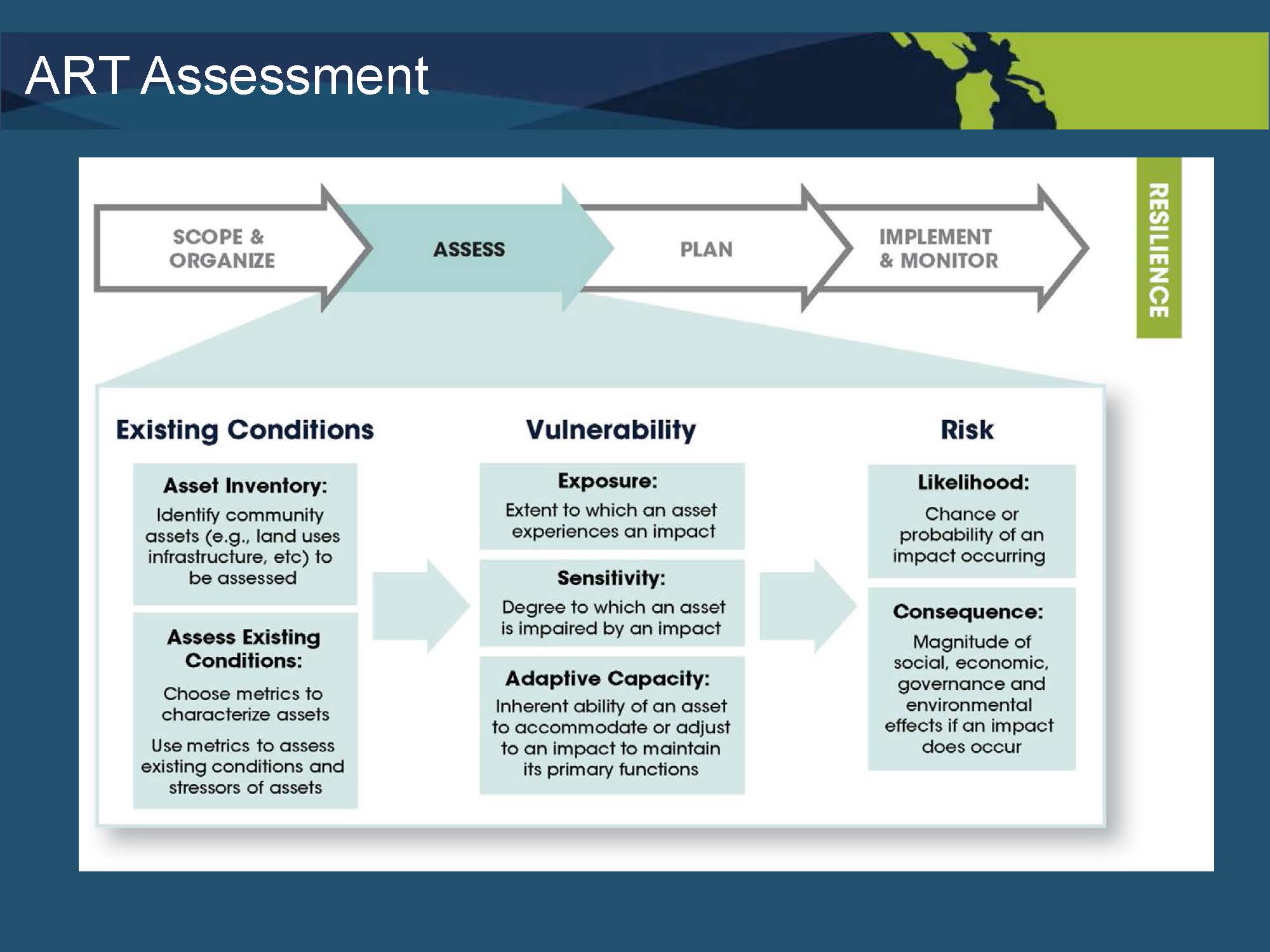
The second step is assessment. “In conducting the assessment, the first thing we did was look at the existing condition of all the assets and try to understand their adaptive capacity and sensitivity based on their exposure to sea level rise,” he said. “We mapped areas based on six scenarios and determined what assets are exposed, and out of that came this 200-page Existing Conditions and Stressors Report that looked at all the different asset categories. Out of that, we did an analysis to understand then what the vulnerabilities were for each of those based on the adaptive capacity and their exposure and sensitivity. And the vulnerabilities are summarized in the Vulnerability Assessment Report. We also identified key planning issues in the sub-region.”
He noted that they considered the consequences to the community for things such as if the hospital goes down, if BART doesn’t work, the freeway can’t be used, or if an endangered species habitat is eliminated to gain a sense of the importance of the different vulnerabilities. “So we’ve prepared this report and developed metrics to assess function and condition.”
 “In addition to looking at fundamental sea level rise issues, we analyzed everything through four frames: Ecology, Environment, Economy, and Governance, because these were all issues that if we didn’t solve for all four of them we would not come up with solutions that worked,” said Mr. LaClair. “Because any one of the interests behind one of those four could thwart your consensus and could prevent you from moving forward. … We didn’t know a lot about social equity, so we wrote a white paper on social equity to look at it in the context of sea level rise planning. We didn’t have a lot of good information about governance, and so we wrote a white paper about governance in the context of sea level rise planning. And it was really helpful to us in terms of beginning to think about what kinds of collaborative structures are needed in order to effectively implement adaptation strategies.”
“A big part of our solution is going to be wetland restoration and resilience,” he said. “But you also have to do the same work on the other side of the levee to really bring people together – eventually you have to bring both of those universes together to come up with solutions because they’re going to be really expensive, and people are going to struggle to pay for them.”
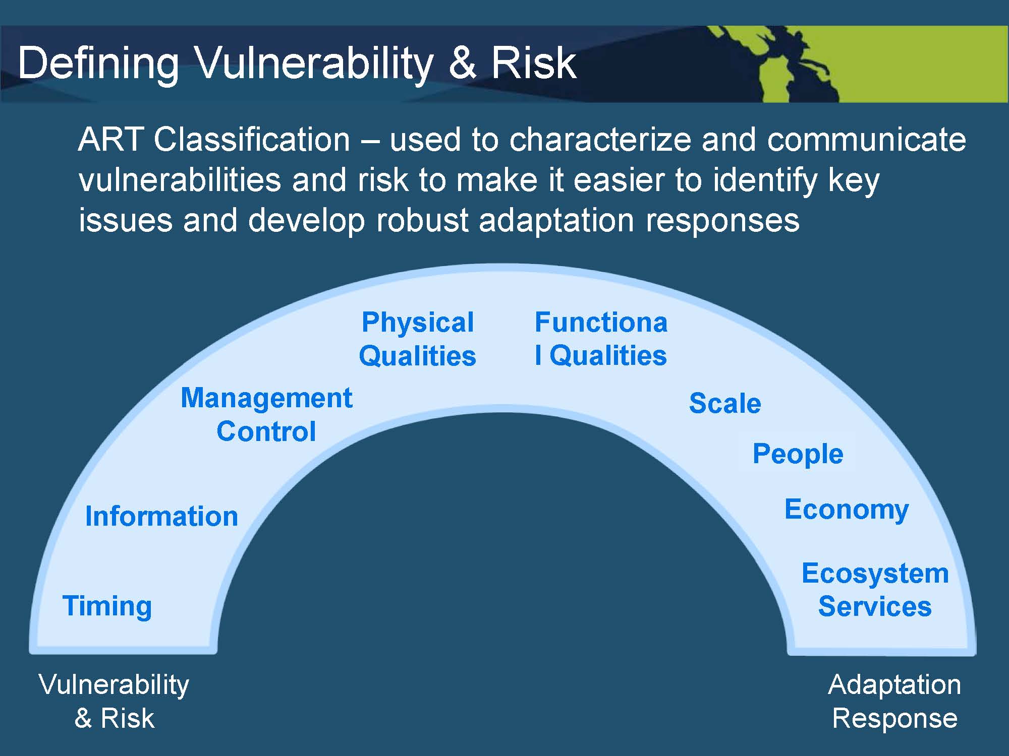 “We built this bridge of classifications of the different kinds of vulnerabilities to help understand how you formulate successful and viable adaptation strategies,” he said. “Issues like timing, when do you do it? Management control, who are the necessary players in order to implement a strategy? Who owns it? Who has permitting authority? Functional qualities, scale, what are the impacts on people and the economy? These were all factors that led to how we structured and articulated the adaptation strategies.”
This allowed us to synthesize the vulnerabilities and risks into a strategy that will work, and there’s a report on our website that explains exactly how we did that, he said. “The goal is to connect actions directly to the assessment outcomes,” he said. “In other words, what we did was identify vulnerabilities and present a number of possible response options, so it’s not just a “one size fits all” because that never works.”
We also characterized actions by type, priority, and implementation and scale, he said. “For example, some of the strategies are what are called unlocking strategies, strategies that you have to do first in order to open up a range of other strategies that wouldn’t even be possible without that first step. – those are the kinds of strategies that we came up with,” he said. “We stayed at the high level. We didn’t get down into the weeds to say build this levee here and that sea wall there and restore this wetland because we’re not at that stage yet.”
Other high level strategies include developing a regional sediment management strategy for the San Francisco Bay, including a collaboration underway in Washington to make it easier for the Corps to allow sediment from dredging to be beneficially used for wetland construction, he said. We’re also considering ways to protect the transit tunnels and other systems that could take the transit system down in the event of a flood or an earthquake, he said. “We also considered vulnerable populations, noting that different populations have different sensitivities or vulnerabilities to sea level rise, some greater than others.”
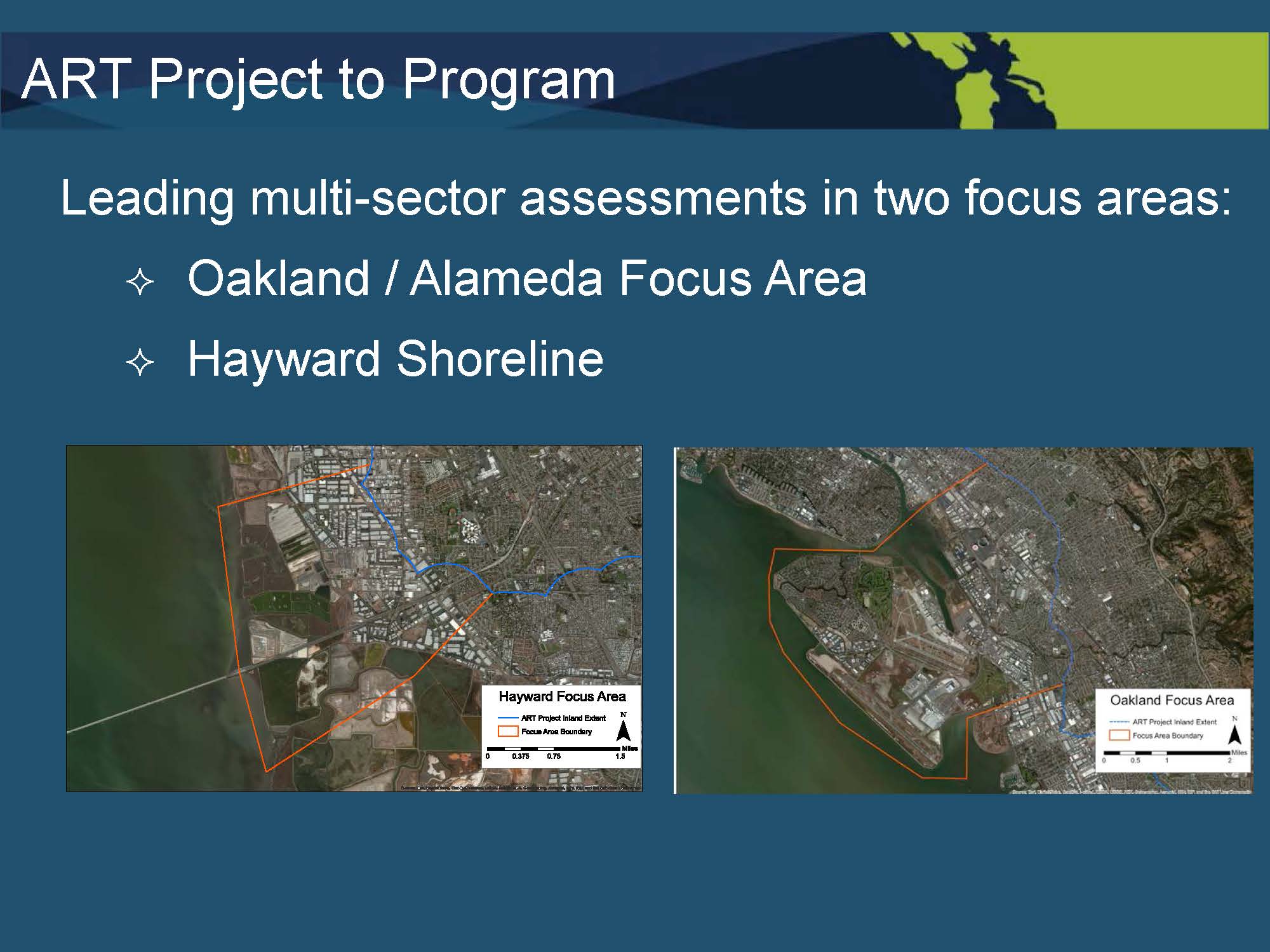 It took three years to finish this project, and now we’re moving into the ART program, which is the more detailed sub-region work from Emeryville down to Union City, he said. “Here are two of the focus areas we’re working, one around the Oakland Airport and Bay Farm Island in Alameda, and the Coliseum area in Oakland. That’s one large focus area that we’re conducting more detailed studies to come up with more detailed adaptation strategies. Similarly, in Hayward, we’re doing the same thing working with East Bay Park District, city of Hayward, Hayward Area Recreation District, and both of these will involve wetland resilience strategies. … We have a NOAA fellow who’s working exclusively with East Bay Regional Park District on crafting strategies for all their shoreline parks in Alameda County and Contra Costa County where they have a number of shoreline units that are going to need some strategies to deal with.”
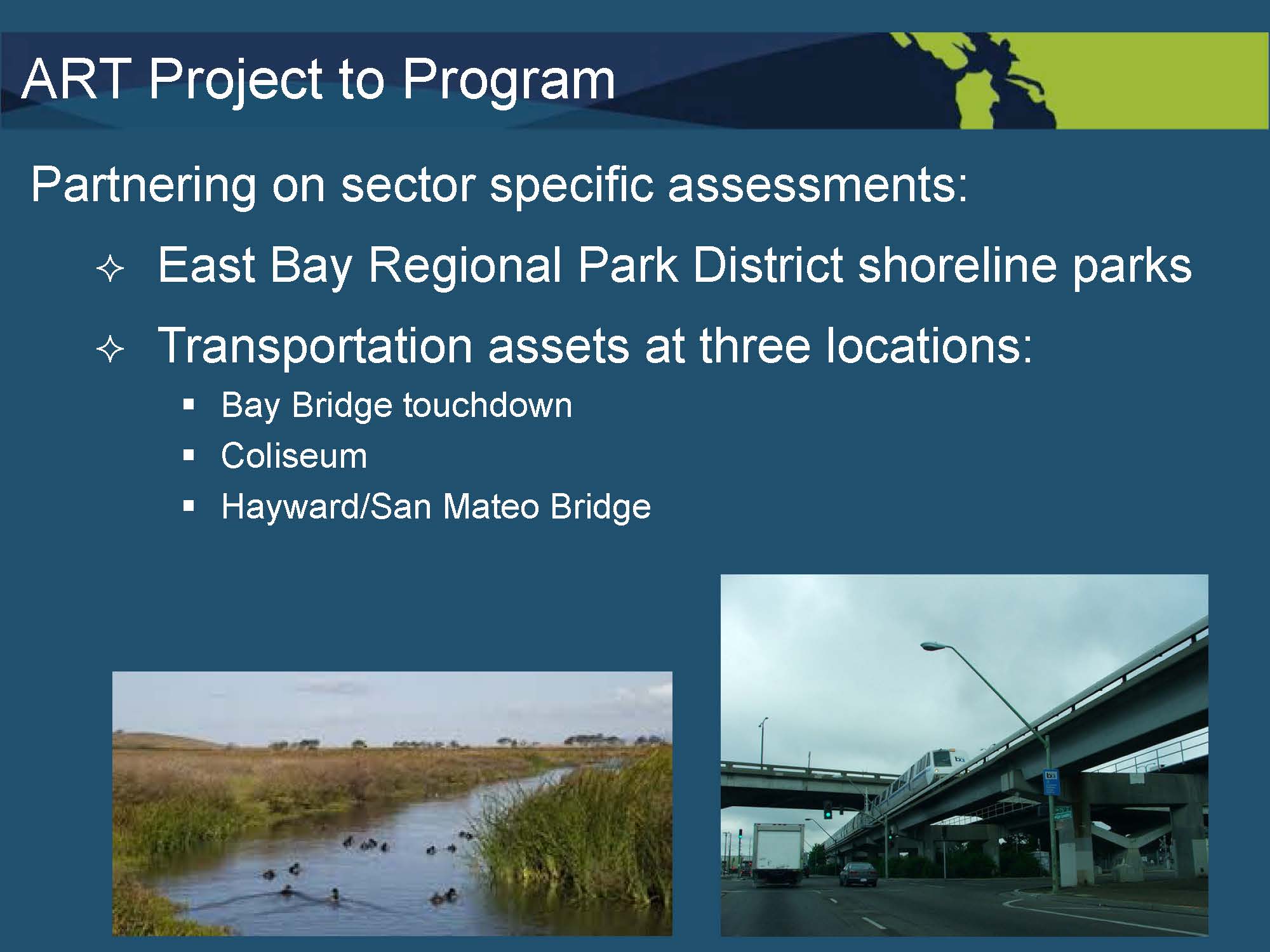 “We’re also looking at doing specific work with BART, Cal-Trans and the Metropolitan Transportation Commission to come up with specific strategies to deal with the Bay Bridge takeoff area, the Coliseum area, and the Hayward San Mateo Bridge,” he said. “In addition, we’re providing assistance to a project in Southern Marin County, San Francisco’s Mission Bay neighborhood near the Giants Ball Park, and Capital Quarter Rail hotspots. … all of them involve wetlands in some way, because they’re all on the shoreline. “
Our objective was to create a replicable process, so the idea is to create print and web-based materials that others can use to replicate this work in their community, in their region, or someplace else, he said, maybe even Vietnam.
“In addition to that, we’re working with ABAG to try and bring earthquake into the mix because we live in earthquake country and much of the vulnerable land is filled land and it’s very liquifiable,” he said. “If you want to build protection on that liquifiable soil, you damn well better know what’s going to happen with that.” He noted that rising groundwater is another concern as hydrostatic pressure in the Bay grows.
 “We’re working with ABAG on understanding what housing risk is in the region both to earthquake and sea level rise, and we have a regional strategy that we’re developing with them and the Coastal Conservancy,” he said. “The Resilient Shorelines Initiative is a project to try and take the ART Project and apply those lessons learned around the region and develop a regional approach. So, we didn’t know how to do it. Now we do, and our next steps are to try this in other places and perfect it and try to figure out what are the regional issues that need to be solved at the regional scale.”
Our first task is to continue this work and feed that into our 2017 Sustainable Community Strategy, and we hope by 2021, we will have the regional strategy in place, he said, adding that they are hoping to obtain funding to get it done faster. We’re also involved with the Bay Area Ecosystem Climate Change Consortium, a group of federal agencies, state agencies, and NGOs that are trying to promote nature-based solutions to make sure that in our rush to protect developed areas, we don’t forget about our wetlands, and that we integrate these nature-based solutions into our flood protection approach, he said.
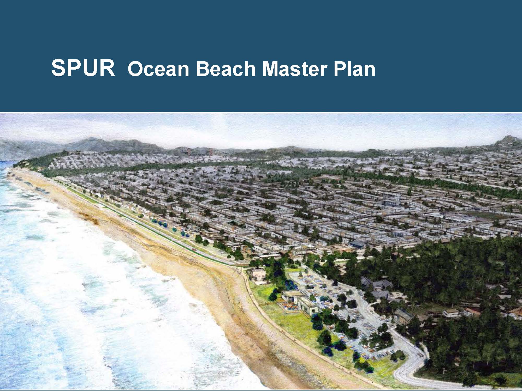 The City of San Francisco had an erosion problem at Ocean Beach that was taking out the Great Highway at times and threatening a sewage treatment plant, he said. “They came up with a strategy working with the San Francisco Planning and Urban Research that rerouted the roadway in the long term. … It creates a little bit more room for the coast, recognizing that the West Coast may not be able to keep pace with sea level rising and sustain all our beaches at the level that they are now.”
Another project underway is called “Our Coast, Our Future” being led by the Gulf of the Farallones National Marine Sanctuary, the San Francisco Bay National Estuarine Research Reserve, and NOAA, and others. “The key player is USGS, because they’re the ones who are developing a hydrodynamic model that will be the basis of a planning tool that folks can use around the Bay, and the neat thing is that we’ll have a hydrodynamic model to model storms and other kinds of conditions that we can’t now, so it’s a really exciting development.”
Discussion highlights
An audience member asked about the concept of resilience. The ‘word resilience’ is much like the word ‘reconciliation’, and is something that a lot of people will get behind, but there can be many different definitions … I’m just sort of curious what resilience means to each of you and maybe how you would measure it?
“In the Baylands Goals, and you’re right this is a totally key term,” responded Letitia Grenier. “What we’re trying to do is create resilient Baylands. Ultimately we want the populations of wildlife to be there; that’s our ultimate goal. But what’s measurable in the amount of resources that are actually out there is, do we have the habitats on the landscape that we want to have in the configuration we want to have? … By resilience, we define it as the ability to persist over time and continue to function … being able to function and provide some of the ecosystem services we want over time despite perturbations.”
“How we measure it is the interesting thing,” she said. “We originally wanted to measure a static quantity of certain kinds of habitats, but now we’d like to be able to change that measurement to, can we have functioning native populations of wildlife over time or sustainable native populations of wildlife over time? And that’s actually our goal, but I don’t think we’re ever going to honestly be able to measure that. So I think we’re going to end up measuring habitat, but how it changes over time.”
“The definition we’ve been working with is the ability to withstand an impact and resume function within a short period of time without significant outside help,” replied Joe LaClair. “That means that if you sustain a flood, you don’t need FEMA to come marching in with trailers and wheelbarrows full of money in order to get your community back up and running. In a nutshell, that’s how we define it.”
Other interesting quotes …
Letitia Grenier: “A lot of projects are happening without a regional vision and they kind of end up going each their own way. It doesn’t add up to as much value as if you have all these projects plugging into one coherent plan that will get you where you want to go. So for the Baylands goals, once you have your historical picture, you have some understanding of how this landscape used to work in the past, and you’ve got whatever remnant wildlife populations you have left that you’re trying to restore or maintain, then you can come at it from both of those ends … this is what we think we need, in terms of habitat, to have these resilient sustainable wildlife populations.”
Joe LaClair: “One of Letitia’s colleagues, Josh Collins, said, we remodeled our watersheds without a plan, and we don’t even know how they work now, and so now we have to figure out how these urban watersheds work. But I think where the interplay comes is identifying areas where the Bay can migrate upland first. Let’s find those undeveloped areas, buy them and save them for that purpose, so that we can have upland transgression which is a normal ecosystem function. There’s going to be some areas that are developed now that we can’t afford to protect. It’s going to take us a while – it’ll probably take us 25 years to come to that realization, but when we do, then maybe we can find a way to get out at some of those areas and allow the Bay to transgress in those areas.”
Joe LaClair: “There are going to be places where we’re going to build sea walls to protect and pump storm water because the value of the real estate is too great. We’re going to have to learn how to live with water. We’re going to have to adjust our expectations. So I think it’s, as Letitia said, it’s getting everybody in a room, sharing the information with them, getting the policy makers up to speed so that they can make the tough choices.”
For more information …
- Click here to watch the presentation on YouTube.
- Click here for Letitia Grenier’s power point.
- Click here for Joe LaClair’s power point.
- Click here for the Baylands Ecosystem Habitat Goals report (1999)
- Click here to visit the San Francisco Bay Conservation and Development Commission website.
- Click here to visit ICLEI: Local Governments for Sustainability USA website.
For even more information …
- Building Resilient Baylands, article from Estuary News
- Click here for more speeches in the California Water Policy Seminar Series.
